www.humantechnology.jyu.fi Volume 9(1), May 2013, 92–108
92
EFFECTS OF POSITIONING AIDS ON UNDERSTANDING
THE RELATIONSHIP BETWEEN A MOBILE MAP
AND THE ENVIRONMENT
Abstract: Positioning technologies such as GPS enable mobile map applications to display a symbol representing an estimation of a user’s location on a mobile map, therefore acting as a positioning aid. Previous research on the cognitive processes involved in map reading suggests that map readers need at least two map–environment points (objects that are visualized on the map and perceived in the environment) for determining their location on a map. Hence, the positioning aid alone does not provide enough information for self-location. Using a field experiment, we assessed the effect of
representing the user’s location on a map on the cognitive processes involved in
self-location. The results show that positioning aids guide the search for map–environment points and narrow the area on the map that must be scanned for self-location.
Keywords:mobile, landmark, spatial cognition, hiking, navigation, GPS.
INTRODUCTION
Imagine yourself strolling in a forest with only a mobile map to guide your navigation. You notice a small pond and boulders on your right. You look at your mobile map and search for the cartographic symbols representing the pond and the boulders. After finding the symbols, you locate yourself on the map.
Recently, topographic maps, the type of map typically used by hikers, have been integrated into mobile applications. Topographic maps symbolically depict landforms and other physical
© 2013 Juho Kässi, Christina M. Krause, Janne Kovanen, & L. Tiina Sarjakoski, and the Agora Center, University of Jyväskylä
DOI: http://dx.doi.org/10.17011/ht/urn.201305211724
Juho Kässi
Cognitive Science Unit Institute of Behavioural Sciences
University of Helsinki Finland
Christina M. Krause
Cognitive Science Unit Institute of Behavioural Sciences
University of Helsinki Finland
Janne Kovanen
Department of
Geoinformatics and Cartography Finnish Geodetic Institute
Finland
L. Tiina Sarjakoski
Department of
Geoinformatics and Cartography Finnish Geodetic Institute
93
objects that can be recognized in the terrain. Today, most mobile devices include integrated positioning devices, such as GPS (Global Positioning System) receivers, that enable applications to plot the user’s location on the map (Raper, Gartner, Karimi, & Rizos, 2007). In the present study, any technologies that enable the plotting of a user’s estimated location on a mobile map are referred to as positioning aids.
Self-location on a map is a process by which a map reader determines his or her own location in relation to the symbols on a map (Blades & Spencer, 1987). Orientation is an important part of self-location on a map because organisms necessarily have a location and an orientation in space (see Klatzky, 1998). In the present study, the concept of self-location on a map refers to the process by which the user determines both his or her location and orientation on a map.
Further, self-location on a map requires the map reader to recognize at least two objects in the environment and their corresponding referring symbols on the map (Aretz & Wickens, 1992; Levine, Jankovic, & Palij, 1982; Levine, Marchon, & Hanley, 1984; Liben & Downs, 1993; Oulasvirta, Estlander, & Nurminen, 2009). However, map applications typically only present one symbol indicating the user’s location on the map. The symbol has a single relation to the environment; hence, representing the approximate location of the user on the map does not provide a sufficient amount of information for self-location.
The nature of landmarks used in map reading and navigation has been studied mainly in urban environments (Denis, Pazzaglia, Cornoldi, & Bertolo, 1999; May, Ross, Bayer, & Tarkiainen, 2003). A study by Brosset, Claramunt, and Saux (2008) showed that the ability to read topographic maps and city maps are based on the recognition of different kinds of objects in the environment. According to Lynch (1960), the uniformity of urban environments affects map legibility and ease of navigation. Conversely, in nature environments, users often must rely on recognizing ambiguous landmarks (L. T. Sarjakoski et al., 2012). The search for map– environment points on topographic maps of rural areas, as compared to on maps of densely built-up environments, may be more demanding because the density of distinctive map objects is lower. Pick et al. (1995) stated that topographic maps are useful when the environment is not artificially structured with routes connecting locations.
The research presented in this paper studies the effect of positioning aids (which enable the representation of the user’s location on a mobile map) on the process of self-location. The paper, based on Kässi’s previous work (2011), presents an experiment employing a combination of the pointing paradigm (Oulasvirta et al., 2009; Thorndyke & Hayes-Roth, 1982) and protocol analysis (Boren & Ramey, 2000; Ericsson & Simon, 1984, 1993).
PREVIOUS STUDIES
Several studies have recognized that determining one’s location on a map is a prerequisite for other map-based tasks (Bluestein & Acredolo, 1979; Ishikawa, Fujiwara, Imai, & Okabe, 2008; Liben & Downs, 1993; Lobben, 2004). Only after the map reader has a conception of his or her own location on the map may he or she proceed to other tasks, such as planning a route to a destination, monitoring whether or not he or she is lost, and deducing the directions to locations displayed on the map (Blades & Spencer, 1987; Board, 1978).
94
1993; Oulasvirta et al., 2009). According to Oulasvirta et al., solving the mapping problem is a prerequisite for self-location on a map. The mapping problem refers to the process whereby the user has to recognize the correspondence between a symbol on the map (e.g., symbol referring to a rock) and its referent in the environment (e.g., a rock in the environment). In the present study, the objects that are recognizable in the environment and on the map are called map– environment points.
However, one map–environment point alone does not provide enough information for self-location. According to the two-point theorem, the map reader needs at least two map– environment points for self-location (Levine et al., 1982; Levine et al., 1984) and for being able to determine the direction towards any third point. Bluestein and Acredolo (1979) have stated that a directional symbol along with one map–environment point may provide the minimal amount of information needed for self-location. The two-point theorem suggests that although a satellite navigation system makes it possible to add a symbol on the map that indicates the user’s location, the symbol alone does not provide enough information for self-location. Even if the user is able to treat the point given by the positioning aid as a map–environment point, additional information is needed for self-location.
The process of recognizing map–environment points consists of two elements: the visual search (Wolfe, 1994) for symbols on the map and the evaluation of their relevance for the self-location process. In map reading, the visual search on the map refers to the ability to identify relevant symbols on the map. The relevance of a symbol is defined either by the user’s ability to recognize the symbol’s referent objects in the environment from a certain position or by the user’s memory of landmarks that he or she has recognized earlier. Because the map reader’s position and memory of the environment influence how the symbol’s relevance for map reading is determined, the map reader’s location in the space affects the problem input (Newell & Simon, 1972) for the self-location task. Figure 1 represents an abstraction of the process of searching relevant map– environment points for the purpose of self-location.
The three-component model of self-location proposed by Liben and Downs (1993) allows for analyzing the prerequisites for solving the mapping problem (Oulasvirta et al., 2009). Liben and Downs (1993) determined that self-location on a map requires understanding three kinds of relations. First, the map reader has to understand the person–space relation (i.e., the map reader’s
Figure 1. An abstraction of the process of finding the relevant map–environment points for self-location, where the user searches the symbols on the map and identifies corresponding landmarks in the environment. The relevance of the symbols on the map is determined by the map reader’s ability to match
95
own location in the environment and in relation to objects in the environment). Second, the map reader has to establish the map–space relation (i.e., understand the correspondences between the map and the environment represented on it). Only after the map reader has a conception of the person–space relation and the map–space relation may the map reader proceed to the person–map relation (i.e., understanding the map reader’s location on a map). The person–map relation includes processes called projection (Bluestein & Acredolo, 1979) and structure matching (Levine et al., 1982). In the process of projection, the map reader has to transform the vertical view of the map into the horizontal view from which he or she is looking at the environment. In structure matching, the map reader connects objects in the environment to the corresponding symbols on the map (Levine et al., 1982; Oulasvirta et al., 2009). As a result of structure matching, the map reader has a set of map–environment points.
The three relations (i.e., person–space, map–space, and person–map) allow for analyzing the possible effects of the use of a positioning aid on the map-reading process (see Table 1 for a summary of the possible effects). The person–space relation covers only the cognitive processes involved in searching and recognizing the objects and landmarks in the environment. Because representing the user’s location on the map only adds information to the map (and no information to the environment), the person–space component of the self-location process remains uninfluenced by use of a positioning aid. Furthermore, the map–space relation refers only to the semantic content of the cartographic symbols on the map and their relation to the objects and landmarks in the environment. By plotting the user’s approximate location on the map, the user receives only one additional symbol that has a relation to the surrounding environment. The most significant effect of the use of a positioning aid may be on the third component of the map reading process, the person–map relation. Because representing the user’s location adds information to the mobile map, it may influence the search for map– environment points. More specifically, the user’s location may either improve or impair two of the elements involved in searching for map– environment points: the visual search for symbols on the map and determining their relevance for self-location.
Table 1. Effects of Plotting User’s Location on a Map on Self-location.
Person–space
relation Map–space relation Person–map relation
Essential features of the components of the
self-location process
Map-reader’s location in relation to the objects in the
environment.
Semantic interpretation: Understanding the referential relation of the
map and environment.
Mapping problem: Understanding the relation
between an object in the environment (point X) and a symbol on the map (point X’).
Effect of representing the map-readers location on the map on
the component of the self-location process
No effect. Representing the location of the map reader adds one symbol
to the mobile map that has a relation to the
environment.
Representing the location of the map reader may improve
or impair the search for symbols on the map and the
evaluation of their relevance for self-location.
Note. The table summarizes the three-component model of self-location on a map (Liben & Downs, 1993)
96
GOAL OF THE RESEARCH AND RESEARCH QUESTIONS
This study is part of an ongoing research project. The goal of the UbiMap project is to develop new knowledge and research methodology related to ubiquitous spatial communication. The focus is the interactive map that is explored as a user interface through which the user is able to interact with the surrounding environment. The case studies of the project focus on hiking in the wild.
The aim of the present study is to assess the effect of representing the user’s location on the map on the cognitive processes involved in self-location. Earlier research found that searching for map–environment points is an essential element of the process of determining one’s location on a mobile map (Liben & Downs, 1993; Oulasvirta et al., 2009). To investigate whether representing the user’s location on the map impairs or improves the search for map– environment points, three research questions were formulated:
Does representing the user’s location influence the time needed to locate oneself on a map? If plotting the user’s approximate location on the map impairs the search for map–environment points, the time needed to determine one’s location on a map will be increased. However, if representing the user’s location improves the search for map–environment points, the time needed for self-location will be reduced. Does representing the user’s location on the map influence the number of map–
environment points needed for self-location? If the user is unable to exploit the information provided by the positioning aid, representing the user’s location with a symbol will not influence the number of map–environment points needed in self-location. On the contrary, if a user benefits from the positioning aid, the number of map–environment points needed in self-location will be reduced.
Does representing the user’s location on the map change the way map–environment points are identified? The search process involved in finding the relevant map– environment points for self-location may be either improved or impaired by use of the positioning aid.
It may be concluded that the information provided by the positioning aid does not influence the search for map–environment points if the time needed to perform self-location and the number of map–environment points needed for self-location is unaffected. However, if the positioning aid use decreases the time needed for self-location and affects the number of map–environment points being sought, it may be concluded that knowing one’s approximate current location on the map guides the search for map–environment points.
METHODS
97
protocols obtained from the participants were used to analyze the mental processes involved in the self-location process.
We organized the present study in a nature environment and used a mobile map application to display topographic maps covering the experimentation area. In half of the tasks, we configured the application to give a location estimate and, in the other half, the positioning aid was not used.
Experiment Site and Participants
Twelve individuals participated in the study. The subjects were, on average, 24 years old, and eight of them were female. Most subjects estimated that their map-reading skill was good (i.e., on scale of 1 to 5, where 4 indicated good map-reading skills). Three individuals reported that they use a smart phone daily, eight reported that they have never used a smart phone, and one reported that she uses a smart phone only rarely. All subjects spoke Finnish as their native language, and the verbal data recorded in the experiment was in Finnish.
The subjects were recruited from the e-mail list of a university student scouting organization. Because the map application used in the study lacked a legend that would have explained the meaning of the symbols and features on the map, only hikers who had experience in reading topographic maps were recruited.
The experiment was conducted near Lake Halkolampi in Nuuksio National Park, located within the capital region of Finland. The park is approximately 30 kilometers northwest of the center of Helsinki.
Map Application and Navigational Aids
We used an early prototype version of the Terrain Navigation mobile map application as a research platform in the study. The application was developed at the Finnish Geodetic Institute as part of the UbiMap project. The Terrain Navigator runs on Apple iPhone mobile devices (Kovanen, L. T. Sarjakoski, & Sarjakoski, 2009).
The map views are manipulated by using the touchscreen. For instance, the map is scrolled by moving a finger along the screen and rotated by placing two fingers on the screen and making a rotating movement with the fingers. Double tapping the screen with one finger zooms the map in, and touching the screen with two fingers at the same time zooms the map out. The application can display maps at six different design scale levels. The scales at the latitude of the test area were 1:2362 (where one centimeter on the map corresponds to approximately 23.62 meters in the environments), 1:4724, 1:9449, 1:18898, 1:37795, and 1:75591.
98
test circumstances. Our test area was more challenging because the satellite geometry was poorer as a result of the surrounding terrain.
Because some hikers typically use a compass as an important navigational aid while hiking, the subjects were also provided with a Suunto A30 scout compass. However, the subjects were not instructed to use the compass.
Pointing Tasks
In the pointing tasks, subjects were shown a target on a map and asked to indicate the direction to the target. They then were instructed to think aloud while performing the task. In all the pointing tasks, the target was marked on the map with a green symbol. To be sure that the subjects had recognized the target and located themselves accurately on the map, they were asked to report the cardinal direction (north, east, south, west) or intercardinal direction (northeast, southeast, southwest, northwest) to the target. The experiment was a 2 × 2 within-subject design, with the following conditions:
Distance to the target. Half of the pointing tasks were proximate and half remote. In the proximate pointing tasks, the target was visible from the site where the task was performed. In the remote pointing tasks, the target was not visible from the task site. Positioning aid usage condition. Half of the pointing tasks used a positioning aid,
and half did not. In the task with positioning on, the map reader’s location was displayed on the map. Otherwise, the location was not plotted.
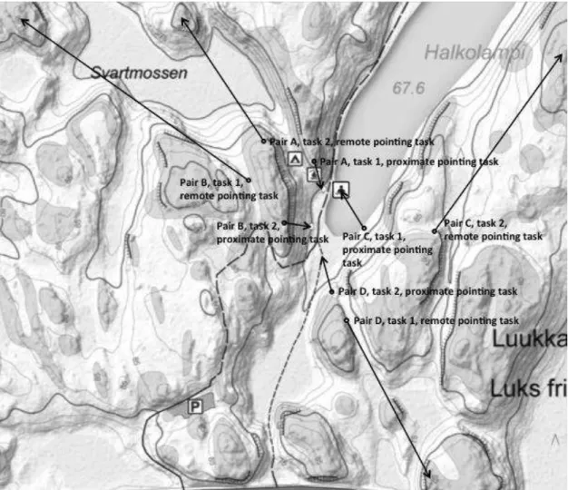
In Figure 2, the circles represent the actual sites where the pointing tasks were performed within the experiment area. The arrowheads indicate the locations of the targets that were shown to the subjects on the mobile map.
To control the order of the tasks, the pointing tasks were divided into four pairs (pairs A, B, C, and D; Figure 2). Each pair contained one proximate pointing task and one remote pointing task. In pairs A and C, the subjects performed the proximate pointing tasks before the remote pointing tasks, and in pairs B and D, subjects performed the remote pointing tasks before the proximate pointing tasks.
The order of the pairs was balanced using the following manipulations:
Five subjects performed pairs A and B with the positioning aid on and pairs C and D without positioning aid; seven subjects performed pairs A and B without the positioning aid and pairs C and D with the positioning aid. Our initial goal was to recruit eight participants to both conditions, but we settled for five and seven after several cancellations.
Six subjects performed the pointing tasks in Pair A before those in Pair B; and six performed the pointing tasks in Pair B before those in Pair A.
Six subjects performed the pointing tasks in Pair C before those in Pair D; and six performed the pointing tasks in Pair D before those in Pair C.
99
Figure 2. The actual sites where the pointing tasks were performed are marked with circles. The arrows point to the targets’ locations. The pointing tasks were divided into four pairs.
Procedure
Subjects carried out the tasks individually with one experimenter guiding them. Before the actual pointing tasks, the subjects performed two practice tasks: one proximate pointing task with the positioning aid switched on and one remote pointing task without the positioning aid. The aim of these tasks was to familiarize the subjects with the Terrain Navigator and to allow them to practice the thinking aloud method described by Boren and Ramey (2000) and Ericsson and Simon (1984, 1993). During the actual test, data were recorded using a digital voice recorder and a video camera. A microphone connected to the recorder was placed close to the subject’s mouth to capture the think-aloud data. The experimenter video recorded the subject’s movements during the pointing tasks.
100
manipulate the map view by zooming and scrolling. However, before each pointing task was started, the map on the mobile application was reset to the scale 1:37795, centered over Lake Halkolampi, and oriented so that north was displayed on the top of the screen.
Because the experiment focused on analyzing the subjects’ mental representations, subjects were instructed to focus their thoughts on verbalizing rather than on completing the tasks as quickly as possible. If subjects were silent for longer than 20 seconds, the experimenter reminded them to start thinking aloud again. No feedback on how well the subjects performed was given during the experiment. During the trials, the experimenter only answered questions concerning the pointing task instructions and how the map view could be manipulated.
Preprocessing the Data
We transcribed the subjects’ audio recordings verbatim. As is often the case in field experiments, loss of data occurred. Specifically, the first three subjects were not recorded on the digital voice recorder due to technical problems. However, in these cases, we transcribed the think-aloud audio from the video recordings. Moreover, after viewing the video recording, we eliminated the audio scripts of 11 tasks (seven no-positioning; four positioning on) from our data, due to the subject having moved significantly away from the chosen site for the pointing task.
We compared the direction from the actual site to the target with the directions reported by the subjects. If subjects reported the direction ambiguously (e.g., “somewhere southeast or south”) the reported direction was deemed correct if either direction was correct. We excluded tasks (three no-positioning) in which the reported direction was deemed incorrect.
With the above eliminations, we analyzed 82 tasks (38positioning on; 44 no-positioning). The compass was used in just 28 tasks (16 positioning on; 12 no-positioning).
DATA ANALYSIS
Data from the pointing tasks consisted of two measures: the time needed to perform the task and the number of map–environment points mentioned while completing the task. We calculated the time needed to perform each task as the time from the subject’s first word (after the experimenter gave the mobile device to the subject) until the subject’s last word. In addition, we used the qualitative data from the think-aloud recordings to analyze how use of the positioning aid changed the strategies used to solve the pointing tasks. We further analyzed the qualitative data by counting the number of map–environment points mentioned by the subjects while they performed each pointing task. This approach follows the quantifying qualitative data technique introduced by Chi (1997).
101
Table 2. Summary of the Map–Environment Points Identified from the Protocols.
Category Terms used by subjects
Roads and paths Road, parking lot, path, trail, intersection, and fork in the road
Buildings and related features
Cooking shelter, shelter, shed, hut, building, woodhouse, outhouse, table, tent site, and fireplace
Lakes and related concepts
Lake, pond, bay, shore, shoreline, beach, opposite shore, water, and pier, or the proper names for these features
Hills and elevation Boulder, ridge, crag, cliff top, cliff, hill, mound, valley, slope, hillside, wall, and mountain
Vegetation Rock, forest, swamps, or the proper names for these features
Other concepts GPS and compass
Note. The table summarizes the map–environment points identified from the think-aloud data. The
categories correspond to the features plotted on topographic maps. Terms were spoken by the native Finnish subjects in Finnish and translated into English here by the researchers.
In addressing a quantitative aspect of the data analysis, we looked at the effect of two factors and one covariate on the time needed to perform the pointing task and on the number of map– environment points mentioned. The three factors explored involved
positioning condition, referring to the experimental conditions in which the user’s location was either plotted on the map (positioning on) or not (no positioning);
distance to the target, referring to the experimental conditions in which the target is either visible (proximate pointing task) or out of sight (remote pointing task) from the actual site where the pointing task is performed; and
verbosity, referring to the total number of words uttered by the subject while completing the task. Because the subjects might vary regarding how much they tend to speak during the tasks, the verbosity was used as a covariate in the analyses.
The data from the experiment involved several trials from each subject, and, thus, the trials from each subject cannot be considered to be independent from each other. To treat the correlation between the observations, statistical analyses were performed using a linear mixed model (LMM), which includes a fixed effect part and random effects part. The fixed effect part of the LMM accounts for the influence of the independent variable data (positioning condition, distance to target, verbosity), whereas the random effects part of the LMM accounts for subject-to-subject variation. The LMM permits the inclusion of multiple measurements from one subject and for missing data, thereby increasing statistical power while controlling for within-individual variation.
The dependent variable data, the time needed to perform the tasks and the number of map– environment points mentioned during the tasks, were entered into an LMM. In these analyses, the factors positioning condition (two levels: no-positioning and positioning on), distance to the target (two levels: proximate pointing and remote pointing), and the covariate verbosity were assessed.
102
the way the pointing tasks were performed, the following statistical analysis was computed: the effect of the positioning condition (two levels), distance to the target (two levels), verbosity, and the interactions between these variables on the number of used map–environment points.
RESULTS
The analysis indicated that the positioning aid reduced the time needed to perform the tasks. The analysis of the number of map–environment points showed that there were qualitative differences in the process between the positioning conditions.
There is a positive, and statistically significant, association between verbosity and the time needed to perform the pointing task, F(1, 39) = 11.377, p = .002. This result shows that the more subjects spoke during a task, the more time they needed to perform the task. Furthermore, the main effect for the factor positioning condition on the time needed to perform the task almost reached the level of statistical significance, F(1, 65) = 3.470, p = .067. The mean time needed to perform the pointing task was shorter in the positioning on condition (M = 69.7 s) than in the no-positioning condition (M = 80.5 s). No other main effects or interactions reached the level of statistical significance on the time needed to perform the task. The statistical tests of the effects of verbosity, positioning condition, distance to the target, and their interactions to the time needed to perform the tasks are summarized in Table 3.
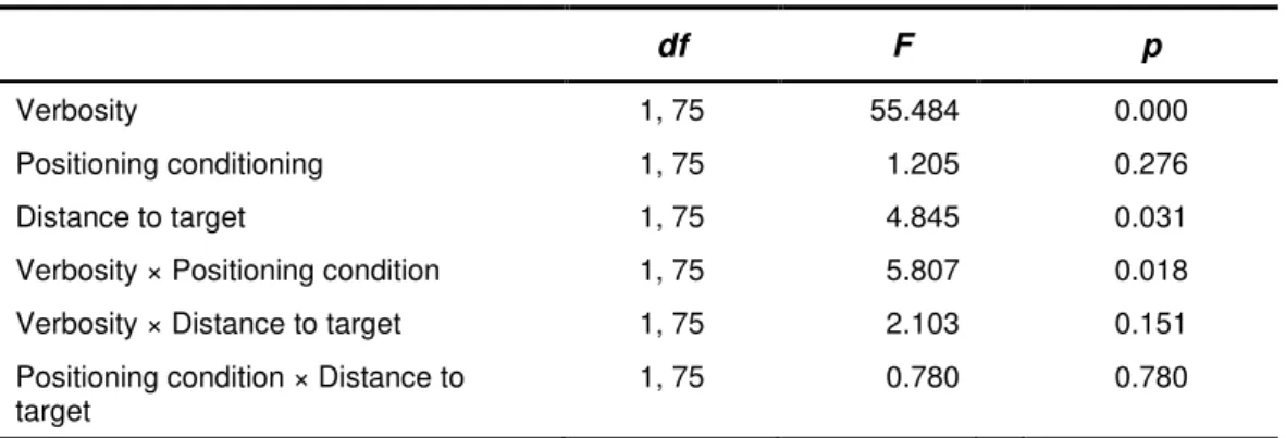
Further, the main effect in the LMM for the factor verbosity reached the level of statistical significance on the number of map–environment points mentioned, F(1, 75) = 55.484, p < .001. The result shows that the more subjects spoke during a trial, the more points they mentioned. The factor distance to the target had a statistically significant effect on the number of map–environment points mentioned, F(1, 75) = 4.845, p = .031. The subjects mentioned, on average, fewer landmarks in the remote pointing tasks (M = 4.8) than in the proximate pointing tasks (M = 5.9). The interaction between the factor positioning condition and the covariate verbosity reached the level of statistical significance on the number of map– environment points mentioned, F(1, 75) = 5.806, p = .018. The statistical tests of the effects of verbosity, positioning condition, distance to the target, and their interactions to the number of map–environment points mentioned during the tasks are summarized in Table 4.
Table 3. Linear Mixed Model of the Main Effects and their Interactions on the Time Needed to Perform the Pointing Tasks.
df F p
Verbosity 1, 39 11.377 0.002
Positioning conditioning 1, 65 3.470 0.067
Distance to target 1, 70 1.208 0.276
Verbosity × Positioning condition 1, 66 1.419 0.238
Verbosity × Distance to target 1, 69 0.970 0.328
Positioning condition × Distance to target 1, 63 0.434 0.512
Note. Significance levels in the linear mixed models were .1%, 1%, 5%, and 10% (i.e., p <.001, <.01,
103
Table 4. Linear Mixed Model of the Main Effects and their Interactions on the Number of Map–Environment Points Mentioned in the Pointing Tasks.
df F p
Verbosity 1, 75 55.484 0.000
Positioning conditioning 1, 75 1.205 0.276
Distance to target 1, 75 4.845 0.031
Verbosity × Positioning condition 1, 75 5.807 0.018
Verbosity × Distance to target 1, 75 2.103 0.151
Positioning condition × Distance to target
1, 75 0.780 0.780
Note. Significance levels in the linear mixed models were .1%, 1%, 5%, and 10% (i.e., p <.001, <.01,
<.05, and <0.1).
Figure 3 displays the linear dependency between the number of points mentioned in the task and the verbosity in the conditions with and without the positioning aid. In addition to the linear model, Figure 3 depicts the mean number of map–environment points in the no-positioning and no-positioning on conditions at four points of the verbosity data (61, 81, 102, 404). These data points correspond to the 25th, 50th, 75th, and 100th percentiles of the verbosity values. No other main effect or interactions reached the level of statistical significance on the number of map–environment points mentioned during the tasks.
DISCUSSION
The present study was conducted to assess the effect of GPS-supported plotting of a user’s location on a digital map on the cognitive processes of self-location in a mobile map context. The study is based on the view that determining one’s location on a map requires the user to recognize points in the environment with respect to the map.
The results indicate that the positioning aid decreases the time needed to perform the pointing tasks. If the pointing task is considered to consist of two phases (self-location and deducing the direction), the positioning aid affects only the self-locating phase of the task.
The interaction between verbosity and the positioning condition has a significant effect on the number of map–environment points accessed. In most cases (more than 75% of the usable data), the number of map–environment points mentioned was lower in the positioning on conditions than in the no-positioning conditions. This difference suggests that the positioning aid reduces the number of points needed for self-location.
104
Figure 3. A linear model of the number of map–environment points mentioned (y-axis 0 - 25) as a function of the verbosity data and positioning conditions. The error bars display the standard error in the mean of the data points. The regression line is based on the linear mixed model (LMM). The standard errors of the means
are computed by comparing the estimations derived from the LMM to the data from the experiment.
The present study indicates that adding a symbol showing the user’s location on a map improves performance in the self-location tasks in nature environments and reduces the number of map–environment points accessed. These findings confirm that the positioning aid helps the user in solving the mapping problem (Oulasvirta et al., 2009) and in understanding the person–map relation (Liben & Downs, 1993). The effects may be mediated by the positioning aid improving the search for additional map–environment points and the evaluation of their relevance.
More specifically, the results from the present study suggest that the positioning aid guides the search for map–environment points and narrows the search area on the map. This theory is in line with the study by Schofield and Kirby (1994). In their study, subjects were shown a location on a miniature model of a landscape, and they were asked to show the location of a target on a topographic map. The reaction time was reduced when the search area on the map was reduced. According to a study by Willis, Hölscher, Wilbertz, and Li (2009), mobile map reading leads to a more fragmented and regionalized knowledge of the space than what can be achieved by reading a traditional paper map. Willis et al. suggested that the small screens of mobile devices might be one of the factors causing the “local” focus
5 10 15 20 25
0 100 200 300 400
Number of map– environment points mentioned
Verbosity
GPS - no positioning
105
of attention during mobile map reading. The present study also suggests that the use of the positioning aid might strengthen the local focus of attention in mobile map reading.
Furthermore, in the present study, subjects mentioned on average more than two landmarks while performing a pointing task. This finding, together with the findings by Aretz and Wickens (1992), signify that the two-point theorem should be considered as expressing the minimal computational principles that govern the process of self-location on a map rather than be a psychologically realistic description of how self-location is carried out. In their study, subjects were shown pseudo-maps displaying arbitrary symbols instead of landmarks and a view of an artificial environment. Subjects were able to connect the view to the pseudo-map fastest when only a few symbols were displayed on the map. As the number of displayed symbols increased, the more the reaction time increased.
The idea that the positioning aid narrows the search area on a map has implications for the design of mobile map applications. According to the present study, self-location on a map requires the user to search cartographic symbols located near the symbol plotting the subject’s location on the map and relate them to the corresponding objects in the environment. However, in real-world map reading tasks, the user may need to switch quickly between multiple tasks (e.g., self-location and route planning). When the information requirements for the different tasks change, the user has to zoom and scroll the map to find the relevant information for each task. The manipulation of the map may cause an increased cognitive load to the user, especially when the maps are displayed on the small screen of a mobile device. Extrapolating, then, the present study suggests that combining large-scale and small-scale maps may help to reduce the cognitive load caused by the different map-based tasks. These kinds of approaches for mobile map applications have been implemented, for example, in the wired fisheye-lens map interface (Carswell et al., 2009) and in the variable-scale approach for small-display cartography (Harrie, L. T. Sarjakoski, & Lehto, 2002).
106
CONCLUSIONS
The paper showed that even with the additional information provided by the positioning aid, the self-location process is governed by the search for map–environment points. The present study disproved the assumptions that the positioning aid either would not affect or would impair the map reading process. Furthermore, the study suggested that the positioning aid might guide the search for map–environment points and help users to determine their relevance for location. This effect may be especially significant in nature environments, where self-location is based on recognizing ambiguous landmarks (L. T. Sarjakoski et al., 2012).
The narrowed-search theory can be seen to have implications for the design of mobile map applications. For instance, because users concentrate more on the area displayed around the symbol representing the user’s location, this area should be plotted in more detail than the remaining map area. However, because the field of human–computer interaction research on mobile map reading is still emerging, the present study and the implications drawn from it may serve merely as an initial step towards integrating cognitive research concerning map reading and the design of mobile map applications.
REFERENCES
Aretz, A. J., & Wickens, C. D. (1992). The mental rotation of map displays. Human Performance, 5(4), 303–328.
Blades, M., & Spencer, C. (1987). How do people use maps to navigate through the world? Cartographica:The International Journal for Geographic Information and Geovisualization, 24(3), 64–75.
Bluestein, N., & Acredolo L. (1979). Developmental changes in map-reading skills. Child Development, 50(3),
691–697.
Board, C. (1978). Map reading tasks appropriate in experimental studies in cartographic communication.
Cartographica: The International Journal for Geographic Information and Geovisualization, 15(1), 1–12.
Boren, M. T., & Ramey, J. (2000). Thinking aloud: Reconciling theory and practice. IEEE Transactions on Professional Communication, 43(3), 261–78.
Brosset, D., Claramunt, C., & Saux, E. (2008). Wayfinding in natural and urban environments: A comparative study.
Cartographica: The International Journal for Geographic Information and Geovisualization, 43(1), 21–30.
Carswell, J., Fotheringham, A., McArdle, G., Yamamoto, D., Ozeki, S., & Takahashi, N. (2009). Wired fisheye lens: A motion-based improved fisheye interface for mobile web map services. In J. D. Carswell, A. S. Fotheringham, & G. McArdle (Eds.), Web and wireless geographical information systems (pp. 153–170).
Berlin, Germany: Springer.
Chi, M. T. H. (1997). Quantifying qualitative analyses of verbal data: A practical guide. Journal of the Learning Sciences, 6(3), 271–315.
Denis, M., Pazzaglia, F., Cornoldi, C., & Bertolo, L. (1999). Spatial discourse and navigation: An analysis of route directions in the city of Venice. Applied Cognitive Psychology, 13(2), 145–174.
Ericsson, K. A., & Simon, H. A. (1984). Protocol analysis: Verbal reports as data. Cambridge, MA, USA: MIT Press.
Ericsson, K. A., & Simon, H. A. (1993). Protocol analysis: Verbal reports as data (Rev. ed.). Cambridge, MA,
USA: MIT Press.
Harrie, L., Sarjakoski, L. T., & Lehto, L. (2002). A mapping function for variable-scale maps in small-display cartography. Journal of Geospatial Engineering, 4(2), 111–123.
107
Kässi, J. V. (2011). Effect of GPS on understanding relationship between mobile map and environment: A field experiment (Master’s thesis, University of Helsinki). Available at
http://urn.fi/URN:NBN:fi-fe201108101998
Klatzky, R. (1998). Allocentric and egocentric spatial representations: Definitions, distinctions, and interconnections. In C. Freksa, C. Habel, & K. F. Wender (Eds.), Spatial cognition (pp. 1–17), Berlin,
Germany: Springer.
Kovanen, J., Sarjakoski, L. T., & Sarjakoski, T. (2009, September). Studying iPhone as a media for context-aware map-based mobile services. Paper presented at the 6th International Symposium on LBS &
TeleCartography, University of Nottingham, UK.
Levine, M., Jankovic, I. N., & Palij, M. (1982). Principles of spatial problem solving. Journal of Experimental Psychology: General, 111(2), 157–175.
Levine, M., Marchon, I., & Hanley, G. (1984). The placement and misplacement of you-are-here maps.
Environment and Behavior, 16(2), 139–157.
Liben, L. S., & Downs, R. M. (1993). Understanding person–space–map relations: Cartographic and developmental perspectives. Developmental Psychology, 29(4), 739–752.
Lobben, A. K. (2004). Tasks, strategies, and cognitive processes associated with navigational map reading: A review perspective. Professional Geographer, 56(2), 270–281.
Lynch, K. (1960). The image of the city. Cambridge, MA, USA: MIT Press.
May, A., Ross, T., Bayer, S., & Tarkiainen, M. (2003). Pedestrian navigation aids: Information requirements and design implications. Personal and Ubiquitous Computing, 7(6), 331–338.
Newell, A., & Simon, H. A. (1972). Human problem solving. Englewood Cliffs, NJ, USA: Prentice-Hall.
Oulasvirta, A., Estlander, S., & Nurminen, A. (2009). Embodied interaction with a 3D versus 2D mobile map.
Personal and Ubiquitous Computing, 13(4), 303–320.
Pick, H. L., Heinrichs, M. R., Montello, D. R., Smith, K., Sullivan, C. N., & Thompson, W. B. (1995). Topographic map reading. In P. A. Hancock, J. M. Flach, J. Caird, & K. J. Vicente (Eds.), Local applications of the ecological approach to human–machine systems (pp. 255–284). New York, NY, USA, Erlbaum. Raper, J., Gartner, G., Karimi, H., & Rizos, C. (2007). A critical evaluation of location based services and their
potential. Journal of Location Based Services, 1(1), 5–45.
Sarjakoski, L. T., Kettunen, P., Flink, H.-M., Laakso, M., Rönneberg, M., & Sarjakoski, T. (2012). Analysis of verbal route descriptions and landmarks for hiking. Personal and Ubiquitous Computing, 16(8), 1001–1011.
Schofield, N. J., & Kirby, J. R. (1994). Position location and topographical maps: Effects of task factors, training, and strategies. Cognition and Instruction, 12, 35–60.
Shepard, R. N., & Hurwitz, S. (1984). Upward direction, mental rotation, and discrimination of left and right turns in maps. Cognition, 18(1–3), 161–193.
Thorndyke, P. W., & Hayes-Roth, B. (1982). Differences in spatial knowledge acquired from maps and navigation. Cognitive Psychology, 14(4), 560–589.
Willis, K. S., Hölscher, C., Wilbertz, G., & Li, C. (2009). A comparison of spatial knowledge acquisition with maps and mobile maps. Computers, Environment and Urban Systems, 33(2), 100–110.
Wolfe, J. M. (1994). Guided search 2.0: A revised model of visual search. Psychonomic Bulletin & Review, 1(2), 202–238.
108 Authors’ Note
This survey is a part of the UbiMap project funded by the Academy of Finland Motive program and is carried out in cooperation with the Finnish Geodetic Institute, Department of Geoinformatics and Cartography, and the University of Helsinki, Cognitive Science Unit.
All correspondence should be addressed to Tiina Sarjakoski
Finnish Geodetic Institute P.O. Box 15
FIN-02431 Masala, Finland Tiina.Sarjakoski@fgi.fi
Human Technology: An Interdisciplinary Journal on Humans in ICT Environments ISSN 1795-6889