26
© Author(s) 2007. This work is licensed under a Creative Commons License.
Development of catchment research, with particular attention to
Plynlimon and its forerunner, the East African catchments
J.R. Blackie
1and M. Robinson
2131 Grahame Close, Blewbury, Didcot, Oxon. OX11 9QE, UK 2Centre for Ecology and Hydrology, Wallingford, Oxon. OX10 8BB, UK
Email for corresponding author: [email protected]
Abstract
Dr J.S.G. McCulloch was deeply involved in the establishment of research catchments in East Africa and subsequently in the UK to investigate the hydrological consequences of changes in land use. Comparison of these studies provides an insight into how influential his inputs and direction have been in the progressive development of the philosophy, the instrumentation and the analytical techniques now employed in catchment research. There were great contrasts in the environments: tropical highland (high radiation, intense rainfall) vs. temperate maritime (low radiation and frontal storms), contrasting soils and vegetation types, as well as the differing social and economic pressures in developing and developed nations. Nevertheless, the underlying scientific philosophy was common to both, although techniques had to be modified according to local conditions. As specialised instrumentation and analytical techniques were developed for the UK catchments many were also integrated into the East African studies. Many lessons were learned in the course of these studies and from the experiences of other studies around the world. Overall, a rigorous scientific approach was developed with widespread applicability. Beyond the basics of catchment selection and the quantification of the main components of the catchment water balance, this involved initiating parallel process studies to provide information on specific aspects of catchment behaviour. This information could then form the basis for models capable of extrapolation from the observed time series to other periods/hydrological events and, ultimately, the capability of predicting the consequences of changes in catchment land management to other areas in a range of climates.
Keywords: catchments, evaporation, land use, East Africa, Plynlimon, water balance
Introduction
In the mid-20th century increasing concerns were arising in the developed world about the ability of water supplies to meet the increasing demands of industry and rising population (Meadows et al., 1972). In the UK, the impact of land management in the catchment areas of the major water supply reservoirs was of particular concern. The Institute of Hydrology (IH) was established in the mid-1960s, charged with determining, on a catchment scale, the effects on water resources of a land-use change from grazing to coniferous plantation forestry. Dr J.S.G. McCulloch, who had been appointed as Director of this new Institute, had relevant experience through having been part of a team which, in the late 1950s, had initiated an ambitious series of catchment-scale studies of the hydrological effects of land-use changes in important stream source areas in East Africa.
27
Objectives of the East African and UK
catchment studies
Both studies had practical objectives arising from conflicting views on the optimum land use in specific areas but also had the potential to provide information of more general applicability. Both were designed to produce accurate quantitative information on the hydrological effects of the competing land uses, but also attempted to tackle the more difficult task of developing the means to extrapolate spatially and temporally the results obtained under the contrasting conditions of tropical and temperate environments.
In East Africa (the modern countries of Kenya, Uganda and Tanzania) in the 1950s, there was intense economic pressure to develop the few high rainfall areas that are the source of the regions perennial rivers. These relatively small areas (< 5% of East Africa) were at high altitude (>2000 m) and the deep, relatively stable soils weathered in situ from volcanic lavas or ash deposits supported indigenous evergreen montane rainforest or bamboo. From them emerged perennial streams which provided the water supplies on which agriculture and the human and animal populations on the dryer lower slopes and the semi-desert plains beyond depended, particularly in the dry seasons. The forestry departments, charged with conserving these stream source areas, also had a duty to increase supplies of timber and yet were under constant political pressure to release more of this land for agricultural development and settlement. On the extensive semi-arid savannah areas where nomadic pastoralists grazed their herds, overgrazing was resulting in accelerating land degradation as denuded soils increased storm runoff and erosion.
In the UK, government policy was to reduce dependence on timber imports, so the Forestry Commission was acquiring large tracts of hill grazing land for conversion to softwood plantations. This was viewed with alarm by the water supply industry which utilised much of these high rainfall upland areas as the supply catchments for its reservoirs; they feared that this land-use change would increase sediment inputs and, particularly after the publication of the results of a lysimeter study by Frank Law (Law, 1956), could substantially reduce water inflows.
THE EAST AFRICAN STUDIES
In Kenya, the forest department had found that it was possible to produce a mature timber crop from such softwood species as Pinus patula and Pinus radiata in the bamboo forest zone of the Aberdare Mountains on the eastern edge of the Great Rift Valley north-west of Nairobi. The agriculture department had also expressed interest in
establishing high density sheep grazing in this zone. These proposed developments were vigorously opposed by downstream users of the rivers emerging from the area. These included the rapidly growing city of Nairobi for which this was the main water supply area, the coffee industry (then Kenyas principal export industry) which relied on these rivers for water for processing the crop and for dry season irrigation, and not least the dense population of small farmers on the lower slopes. All feared that the proposed developments would increase wet season stormflow and sediment loadings and, in particular, decrease dry season flow thereafter.
Also in Kenya, a highly productive tea industry had become established on the lower slopes of the South West Mau escarpment and the companies were pressing for excision from forest reserve of higher forest areas for further development of tea plantations. These proposals caused concern because of their effects on the quantity, quality and time distribution of streamflow available to the downstream users.
In southern Tanganyika, now Tanzania, political pressure for more forest land to be made available for settlement was rising and the forest department was seeking independent evidence to justify the maintenance of conservation status on sensitive headwater areas.
In north-east Uganda, the problem of overgrazing was particularly severe in the Karamoja district, where a combination of circumstances had led to a rapid increase in human and animal populations. Overgrazing of the savannah grassland was causing increases in storm runoff and erosion resulting in degradation to bare soil and thorn scrub.
In the mid-1950s the East African Agriculture and Forestry Research Organization (EAAFRO), whose remit covered the area of the present countries of Kenya, Uganda and Tanzania, was charged with obtaining quantitative information on the effects of these land-use changes on water resources. The deputy Director of EAAFRO and Head of the Soil Physics Division, Dr Charles Pereira, thought to study the changes by catchment experiments. He recruited two young scientists in 1956 to oversee this work, Dr Jim McCulloch and Dr Matthew Dagg. After much survey work and discussion, four catchment studies were proposed to and agreed by the relevant government departments; with their active cooperation and that of relevant private sector companies, the following themes were investigated.
28
agriculture and to Nairobi city. For this study three small adjacent catchments in the bamboo zone of the southern Aberdare range near Kimakia village (altitude 2438 m, latitude 0o
48´S, longitude 36o
45´E) were identified and instrumented (Plate 1).
(2) The effect of replacing indigenous evergreen montane rain forest by tea plantations in the South West Mau
Plate 1. Kimakia land use, (a) Pines, (b) Bamboo
Plate 2. Kericho land use, (a) Montane rain forest, (b) Tea estate.
(a)
(a)
area of Western Kenya on water supplies to the large rural population downstream. For this study, the headwaters of two parallel streams in the forest area above the existing tea estates south of Kericho township (altitude 2200 m, latitude 0o
21S, longitude 35o 20´E) were chosen (Plate 2).
(3) The effects on streamflow and sediment yields of
(b)
29
Plate 3. Mbeya land use, (a) seasonal cultivation, (b) on steep slopes.
Plate 4. Atumatak land use, (a) Overgrazed savannah, (b) Restored. subsistence cultivation on steep volcanic ash derived soil slopes as compared to that of the indigenous montane rainforest cover in the Mbeya region of southern Tanzania. For this study two small parallel catchments on the north-western side of Mbeya peak (altitude 2428 m, latitude 8o
50S, longitude 33o 28´E) were identified, one of which had recently been cut off from the forest and clear-felled whilst the other remained under forest (Plate 3).
(4) The effects of introducing bush clearing and grazing control on storm runoff, flow duration and erosion as a means of rehabilitating overgrazed semi-arid rangeland in the Karamoja district of northern Uganda. For this study two adjacent parallel small valleys similar in area,
altitude range and degree of degradation, some 30 miles south of Moroto township at a place known as Atumatak (altitude 1574 m, latitude 2o
14´N, longitude 34o
39´E) were chosen (Plate 4).
Details of all these catchments, their initial instrumentation and preliminary results from them are given in Pereira et al.
(a)
(a)
(b)
(1962). The research catchments were operated until 1974 by which time over 130 station-years of data had been collected. Thereafter, the stream gauges at Kimakia and Kericho continued to be maintained as part of Kenyas national hydrometric network.
THE UK STUDIES
The forestry vs grazing vs water supply conflict in UK was particularly acute in the Welsh uplands where a concentration of reservoirs supplied water to the English industrial midlands, either directly or indirectly, through controlling the flow in the rivers to optimise abstraction downstream. After extensive surveys IH chose two adjacent catchments on the Plynlimon massif (4o
45´W, 52o
28´N) in mid-Wales for the study. These were the headwaters of the Wye and Severn rivers, the former devoted entirely to grazing and the latter having the lower 70% of its area under plantation softwoods, mainly fast growing Norway and Sitka spruce.
To supplement the Plynlimon study a small headwater catchment of the river Irthing in Cumbria, the Coalburn (2o
37W, 55o
0N), was selected and instrumented to study the progressive changes in hydrological response as the land use was changed from moorland grazing to plantation forestry. To cover later developments in planting methods on upland moorland, a further pair of catchments on Llanbrynmair Moor (3o
37´W, 52o
40´N), some 20 km NE of Plynlimon was instrumented and, at a later stage, the studies were extended to include the effects of afforesting upland heather-clad moorland, a situation more common in Highland Scotland than the upland grazing addressed in the earlier catchments. For this study two catchments in the Balquhidder area of Perthshire (4o
25´W, 55o
55´N) were selected, one under heather moorland and the other under
Plate 5. Plynlimon land use, (a) Upland grazing, (b) Conifer plantation.
softwood plantation approaching maturity. These catchments also offered the opportunity to monitor the changes occurring as one was progressively felled and replanted and the other was planted for the first time.
Detailed descriptions of the establishment phases and initial results from these studies were given for Plynlimon by Painter et al., 1972, Clarke and Newson, 1978; for Coalburn by Robinson (1980, 1986); for Llanbrynmair by Hudson et al. (1997) and for Balquhidder by Blackie (1987, 1993).
GENERAL APPROACH TO CATCHMENT STUDIES
The first true catchment study often cited (Keller, 1988), was the comparison of two small catchments (~60 ha) established in 1900 in the Emmental region of Switzerland. One was almost completely forest-covered and the other was mainly (70%) pasture. The forested catchment had 10% lower annual streamflow, but a less extreme range with lower peak flows and higher baseflows. Penman (1963) questioned the findings on the basis of his re-examination of the water balances and his own estimates of likely evaporation rates. There was the possibility that the catchments were not watertight, and also the suggestion that the land-use differences were not random but reflected physical differences between the catchments, particularly in their soils.
The first paired catchment experiment, with a deliberate change in vegetation cover whilst keeping other factors constant, was that of Wagon Wheel Gap, USA (Bates and Henry, 1928). Two small (< 1 km2
) forested catchments were instrumented and a close relation between their flows was observed over an eight-year calibration period. The forest was then removed from one basin and the relative increase in streamflows was observed and quantified.
There then followed numerous catchment studies of
forestry effects such as those at Coweeta in USA (Swank et al., 1968) and at the Jonkershoek and Cathedral Peak basins in South Africa (Wicht, 1966). Unfortunately, many experiments were not well designed so that it was not possible to extrapolate their results to other areas. For example, there was often a failure to distinguish between the effects of logging and of a complete change in land cover. Many of the effects observed were more the result of soil compaction and logging roads than of the removal of the forest biomass. Such shortcomings led to a great deal of criticism of catchment research (e.g. Ackermann, 1966).
These criticisms of traditional paired catchment studies included:
(a) length of time required to provide reasonably precise between-catchment relationships in both calibration and treatment mode;
(b) poor estimation of catchment average precipitation; (c) lack of understanding of the causes of any differences
between catchments. Catchment studies generally found a difference but there was no knowledge of why. This resulted in an inability to extrapolate to other areas with confidence
Despite their limitations, catchment studies are the only way to demonstrate the effect of a change in land use at the catchment scale, in a way that plot studies and mathematical models fail to do. In East Africa, Pereira and his team were conversant with the American, European and South African forest hydrology studies and of the criticisms they had attracted. Hence, care was taken to adopt a rigorous scientific approach and to embed process studies within the catchment framework, initially in East Africa and subsequently at Plynlimon. Without a knowledge and understanding of the processes taking place and of the way these are related to the climatic environment, the results of catchment experiments are difficult, or impossible, to extrapolate elsewhere; so the observations and conclusions are applicable only where the same set of processes are operating in the same environment.
Because of the urgent need to acquire guidance on the pressing land-use problems, it was considered inappropriate to follow the classical paired catchment approach in which statistical relationships between streamflows or between rainfall and streamflow from the catchments under the same land use are determined over a decade or so, with due allowance for any minor differences in rainfall; departures from these relationships following the land-use change in one catchment provide a means of quantifying the hydrological effects of the change.
Instead, an approach was developed based on quantifying the water balance of each catchment and relating the calculated water use to the potential evaporation rate in the area, as estimated from meteorological measurements by the Penman equation (Penman, 1948). This powerful combination of water and energy balances offered the opportunity, not only of obtaining results on a timescale more relevant to the needs of the user community, but also of providing a possible means of extrapolating the results beyond the immediate area and time.
Assuming that a catchment is watertight, a simple water balance may be represented as:
AE = P Q DS
Where, AE = catchment water use, P = precipitation input, Q = streamflow from the basin and DS = storage change within and beyond the vegetation root range.
This approach requires accurate and reliable measurements of catchment area and of all the main elements of water balance, including soil moisture and groundwater change. An independent estimate of the potential evaporation, EO, such as that provided by the Penman (1948) open water equation, can set an upper limit to the catchment losses. If AE as calculated above exceeds this by a significant or highly variable amount over successive water years in well-watered catchments, then errors in the measurements and/or catchment leakage are indicated. Computation of a water balance over successive short intervals within the water year using the AE/EO ratio to estimate AE provides estimates of catchment mean soil moisture at each interval. Comparison of these with the estimates obtained from field measurements provides a further check on the validity of the catchment and the data. This choice of approach owed much to the considerable influence exerted on EAAFRO at this time by its close contacts with the Rothamsted Agricultural Research Station in the UK. Many of the EAAFRO senior staff, including Dr Pereira and Dr McCulloch were Rothamsted graduates; from his Rothamsted physics laboratory, Dr Howard L. Penman whose energy balance approach to evaporation estimation had so revolutionised crop water use philosophy took a close and continuing interest in the East African studies.
INSTRUMENT DEVELOPMENT FOR A RIGOROUS
SCIENTIFIC APPROACH
The hydrological instrumentation available in the 1950s was primitive by todays standards. Storage raingauges, clockwork chart recorders for streamflow, manually read meteorological instrumentation and soil moisture measured by laborious manual gravimetric sampling and oven drying were the methods used. The most sophisticated instruments used initially on the East African catchments were the Gunn Bellani radiation integrators (Pereira, 1959) for solar radiation inputs to the Penman equation and gypsum blocks (Pereira, 1951) for monitoring soil moisture profile trends between sampling dates. The quality of the data collected was dependent on network design and regular instrument inspection and maintenance; since the catchments were 110, 240, 1400 and 640 kilometres away from EAAFRO laboratories, the success of the project was largely dependent on the training and dedication of the local field observers. Data processing, storage and analysis were entirely paper based, with all computation done using mechanical calculators.
By the time the UK catchments were first instrumented in the late 1960s, relatively little had changed. The need to develop instrumentation capable of reliable operation in remote, inhospitable field conditions was recognised as a priority and a programme of instrument development was initiated. The production of design concepts and prototypes which were then developed by private sector companies led to much of the array of field instrumentation taken for granted today, such as automatic weather stations (Strangeways and McCulloch, 1965; Strangeways, 1972) and neutron soil moisture meters (Bell and McCulloch, 1969), and to the adoption of solar powered solid state loggers as standard data collection platforms. As they were proven, these developments were incorporated in the Plynlimon networks. Except for the data loggers which became available too late for the East African studies, they were also used alongside the existing networks in the two Kenya catchment groups to provide checks on the quality and extend the sampling frequency and spatial coverage of data collection.
Comparisons and contrasts between
East Africa and Plynlimon
PRECIPITATION MEASUREMENT
Precipitation on the East African catchments was predominantly convective, giving high intensities and large drop sizes. This, together with low wind speeds, meant that
rainfall measurement was relatively straightforward. To ensure that catchment rainfall was estimated adequately, stratified random sampling networks were designed (McCulloch, 1962). To minimise disturbance of the vegetation covers where no natural clearings were available, the network raingauges were mounted at canopy level in each vegetation type using either tree platforms, extending towers or posts. This technique was used subsequently in the forested area of the Plynlimon catchments.
Precipitation measurement presented much greater problems on the Plynlimon catchments which, whilst receiving annual totals similar to those in the East African high rainfall catchments on similar numbers of rain days, did so in very different ways. In the UK, low intensity, small drop size frontal rainfall and high wind speeds prevailed and a small but significant percentage was received as snow. In these conditions, rainfall measurement using standard gauges with apertures 30 cm above ground on open hillsides is prone to undercatch by 510% or more, and snow measurement is very problematic. For the accurate measurement of rainfall to provide a catch equivalent to that if the gauge had not been present on the grassland areas of Plynlimon required a different approach. Ground level gauges had been used experimentally for many years and found to give higher catches (Rodda, 1967a, b). These gauges had not been widely adopted in the UK because the 2%5% higher catch, even in standard exposure conditions, would have created a discontinuity in long-term meteorological series. Ground level gauges are also more difficult to maintain and they are worse than standard height gauges in snow. Nevertheless, a simplified version capable of installation parallel to the local land slope was developed and installed on the grassland sites in the Plynlimon networks. Due to the importance of wind, the stratified random sampling network design at Plynlimon incorporated slope and aspect as well as altitude. To cope with the snow problem, a sub-network of standard gauges was mounted conventionally and read after each snow event.
STREAMFLOW
On both the East African and UK catchments, the siting of the streamflow structures was based on detailed geological and hydraulic surveys to avoid bypassing. The original structures were designed, installed and calibrated by the relevant government department in each East African country and by the Hydraulics Research Station in the UK, with subsequent work on checking and refining the calibrations being carried out in-house.
very low storm runoff responses (generally in the range 1
3% even in the most intense storms of 100 mm h
¹ or more on these deep, porous volcanic soils) and sediment loads. By contrast, the measurement of the intermittent, silt laden torrent flows from the eroded basement complex soils at Atumatak presented difficulties which were never fully overcome (Edwards, 1979).The compound critical depth flumes installed there were designed to be self-cleaning and may have achieved this on the rising limb of the hydrograph but deposition on the falling limb caused changes in bed profile and blocked the float well access pipes. Field checks on the calibrations in this situation of very erratic rainfall and short-lived flows at this remote location were almost impossible.
At Plynlimon, intensive field checks on the structures led to progressive refinements of the calibrations and ultimately to a high degree of confidence in the accuracy of the flow data.
One of the main contrasts between the East African high rainfall catchments and Plynlimon lay in the difference in the proportion of the annual precipitation input emerging as streamflow. For these East African catchments, it was in the range 3045% as compared to 7580% at Plynlimon. Thus, a percentage error of 12% in streamflow estimation was much less significant in the water balance determination of water use than a similar error at Plynlimon.
SOIL MOISTURE
The volcanic soils in the Kenya catchments in East Africa were stone free and remarkably uniform in physical structure spatially and to depths of 5 metres or more. Roots of the indigenous forest penetrated to and beyond these depths but the bulk of the active root system was in the top 3 m. Laboratory analysis of profile volume cores to this depth from three representative sites per catchment gave values of field capacity, wilting point and bulk density at 0.3 m intervals. Initially, gravimetric samples taken close to these sites were used to provide monthly estimates of catchment soil moisture storage change. The advent of the newly developed neutron probe in 1968 made possible more frequent estimates on denser networks and to greater depths. Sampling in the layered, ash-derived soils overlying gneiss in the Mbeya catchment proved more problematic due to a stone layer across much of the catchments at an average depth of 1.1 m. Sampling to this depth was adequate for the moisture abstraction by the seasonal crops grown on the cleared and cultivated catchment, but the forest root systems exploited the profile to much greater depths and sampling had to be supplemented by gypsum block profiles in the forested control catchment.
Regular sampling in the complex heavily eroded soils of the Atumatak catchments was not feasible. Instead, gypsum block profiles were installed under each main vegetation type and read at 10-day intervals to give qualitative information on profile depletion and recharge.
At Plynlimon, the generally shallow, but complex, soils overlying fractured bedrock (Bell, 2005) posed much greater problems in attempting to obtain estimates of catchment mean soil moisture storage than had the deep, physically uniform volcanic soils in Kenya. The advent of the neutron probe and, much later, the capacitance probe, made for simpler and quicker field observations but interpretation of the data in terms of catchment mean values was very difficult. However, the fact that the vegetative types present rarely extracted moisture from deeper than 0.9 m meant that the maximum possible deficits represented less than 10% of annual streamflow (Clarke and Newson, 1978), compared with up to 70% in the E. African catchments (Pereira et al., 1962). With a suitable choice of water year, soil moisture change could be ignored in the determination of annual water use.
POTENTIAL EVAPORATION
By the late 1950s, the Penman estimate of open water evaporation (EO) was becoming the accepted reference with which crop water use was compared in East Africa, whereas the UK adopted Et , the potential water use of short grass, a concept having little meaning in East Africa. Both required meteorological inputs of net radiation, saturation deficit and windspeed and tedious manual computation in pre-computer days. Since no instrument suitable for field operation was then available, net radiation in East Africa was estimated from solar radiation which in turn was estimated from measured sunshine hours (Glover and McCulloch, 1958) or was measured using the simple Gunn Bellani instrument (Pereira, 1959). The tables developed by McCulloch (1965) incorporated the pressure corrections required for the wide altitude range encountered in East Africa and simplified the computations. Considerations of security and the area required for acceptable exposure restricted the East African studies to one meteorological site, read twice daily, per catchment.
simplified and speeded up the computation of potential evaporation at Plynlimon and Balquhidder. These networks identified significant gradients in Et with altitude and exposure.
PROCESS STUDIES AND MODELLING
Although the expression process studies had not come into common parlance when the East African studies were initiated, studies of crop water use, of its relationship to soil moisture deficit, of the effects of agricultural practices on infiltration, storm runoff and erosion and of the micrometeorology of the crop environment were all part of the ongoing programme of the Soil Physics Division of EAAFRO. It was natural, therefore, that every attempt was made to apply this existing expertise to the soils, vegetation and land-use practices on the catchment studies to obtain a greater understanding of the key factors controlling the transformation of rainfall and energy inputs into evaporation, streamflow and sediment outputs. However, the very limited resourcesand the unsuitability for use on remote sites of such instrumentation as was available placed severe constraints on such activities. Bad luck and political pressures also played a part, as when a parallel study of forest interception of rainfall and mist had to be closed abruptly when the newly instrumented forest area was excised for peasant agriculture. Nevertheless, useful work was done on storm runoff and sediment load changes brought about by the land-use changes on each catchment (Dagg and Pratt, 1962), on comparison of soil moisture depletion rates under each vegetation type (Eeles, 1979) and on the measurement of the water use of tea using the EAAFRO design of hydraulic weighing lysimeter (Dagg, 1970; Wangati and Blackie, 1971). The gypsum block profiles under each vegetation type provided information on the timing and profile pattern of moisture extraction from the root ranges. This was particularly valuable on the Mbeya andAtumatak catchments where soil sampling was limited or absent and it was not possible to deploy neutron probes. After IH became involved, process studies were undertaken, mainly on the tea areas at Kericho where the depth and simplicity of the soils and the uniformity of the canopy structure provided ideal conditions for a sophisticated micrometeorological study of water use (Callander and Woodhead, 1979) and an intensive soil moisture study (Cooper, 1979), both of which produced short-term estimates of crop water use in broad agreement with the catchment scale results and the lysimeter figures.
In the UK, it could be said that a process study was most influential in the sequence of events that led, initially, to the creation by DSIR of the Hydrological Research Unit, the
forerunner of IH, and eventually to the Plynlimon catchments. A water engineer, Frank Law, was so concerned that the water use by young forest growing vigorously in the gathering grounds of his reservoir was decreasing the water yield that he established an experimental study of the water balance of a natural lysimeter (0.045 ha) within a Sitka spruce forest at Stocks reservoir in NW England (Law, 1956, 1957).Total water loss from the forest was found to be some 50% greater than the calculated Penman potential evaporation for short grass. This finding that the water lost to the atmosphere from the forest was so much greater than that from grassland was treated with some scepticism and criticism. especially from foresters. The view that a full scale catchment study was necessary to resolve the issue was a factor in the establishment of the Plynlimon study.
IH considered that, while catchment studies were a necessary part of the approach to the problem, it was essential also to explore the reasons for any differences that the catchment study might reveal. To this end, studies of what were considered to be the key processes involved in the transformation of precipitation and energy inputs to streamflow and evapotranspiration outputs were initiated. These included a comprehensive micrometeorological and soil moisture study of energy and moisture fluxes in the extensive Thetford forest in East Anglia (Stewart, 1977) and a forest lysimeter study within the catchments at Plynlimon (Calder, 1976) as well as detailed studies of soil moisture depletion under grassland and forest rainfall interception. Results from these, combined with the work of Monteith (1965) in his theoretical development of the Penman equation, provided a much clearer understanding of the reasons for the higher evaporative losses from the forested Severn catchment than from the grassland Wye which became evident from the early catchment data. At a later stage, forest interception studies (Johnson, 1990) and weighing lysimeters, used to study the evaporative losses from heather (Hall, 1987) and high altitude grassland (Wright and Harding, 1993), provided a means of interpreting the between-catchment differences observed in the Balquhidder study.
catchment and parameters derived from process studies. All
require inputs of catchment precipitation and meteorological data, from multiple points over the catchment grid in the case of the distributed models, and the quality of these inevitably dictates the quality of the forecasts. They also require high quality catchment output flow data against which the forecasts can be verified.
When forecasts disagree with observed catchment outputs, the question arises as to whether this is due to poor data quality or model inadequacy. Such periods of creative tension force both modellers and data collection teams to reassess the situation and lead to improvements in the quality of the data as well as in the process representation in the model.
WATER CHEMISTRY
When the Plynlimon study began there was little or no consideration of water chemistry since these upland waters were considered to be pristine. One of the big developments over the last 20 years at Plynlimon has been the addition of water quality studies. This began in the 1970s with concerns about nutrient loss from fertiliser application to forestry and improved upland grassland causing problems of eutrophication of surface reservoirs and increased water treatment costs (Roberts et al., 1984). Subsequently, there were concerns about acid rain and the acidification of upland waters (UKAWRG, 1988) with implications both for drinking water (e.g. aluminium toxicity) and as a part of the wider recognition of its importance for ecology. It also became increasing apparent that water quality can be an important indicator of subsurface flow processes and water provenance.
The Plynlimon catchments were considered to be water-tight since they are underlain by impervious Lower Palaeozoic bedrocks. There is a limited amount of shallow groundwater within the catchments within the upper fractured zone of regolith and glacial deposits (Bell, 2005). Water from this shallow store helps to sustain stream baseflows and there is evidence of artesian pressures in shallow boreholes at the lower end of hillslopes. The greatest significance of these waters (Neal et al., 1997) is their impact on water chemistry.
In many storm periods, while the rainfall produces a response in the stream, much of the stream flow is derived not from the rain itself but from old water water displaced from within the catchment. This is shown by the high damping in the streams of rainfall input tracers such as chloride and stable isotopes of water (Neal and Rosier, 1990).
Results and their practical relevance
EAST AFRICAN STUDIES
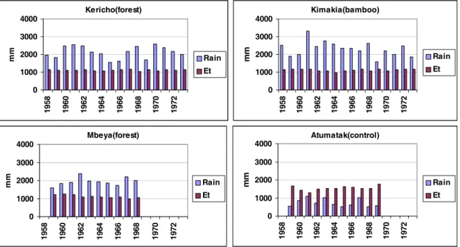
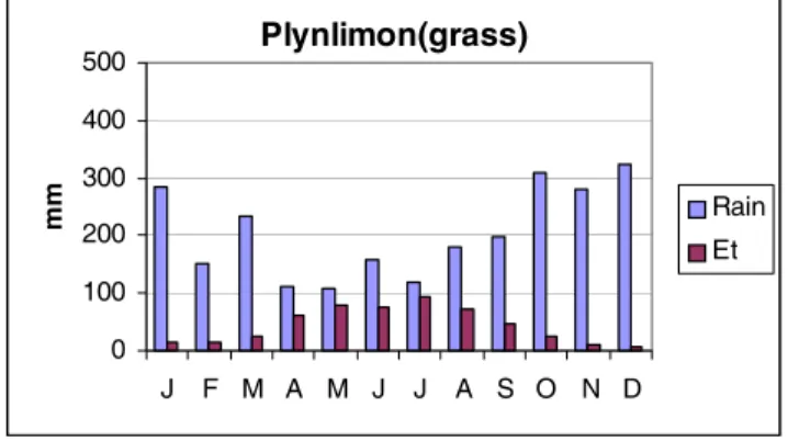
The final results from these studies were described in detail in Blackie et al., (1979) and summarised in Edwards and Blackie (1981). For comparison with UK results, the EO figures in the original papers have been replaced in this paper by Et values calculated from the same meteorological data. The relationship between them depends on the relative importance of the net radiation to the other terms in the equation and for the East African catchments was in the range: 0.8EO > Et > 0.7EO. The range of annual totals of rainfall and Penman Et and their seasonal variability are illustrated in Figs. 1 and 2. These show that rainfall exceeded Et for an average of ten months in the year at Kericho and Kimakia but for only six months at Mbeya. On the semi-arid Atumatak, rainfall rarely approached the potential evaporation level. For comparison, the seasonal pattern of rainfall and Penman Et at Plynlimon is illustrated in Fig. 3. In Table 1, mean AE/Et ratios are compared for each of the high rainfall series during the land-use changes and after they had stabilised. At each stage, the water use of the treated catchment is also expressed as a percentage of that of the control catchment.
The most clear-cut results were obtained from the Kimakia study. There, water use was reduced during the establishment period of the pine plantation but, from canopy closure onwards, there was no significant difference in water use between the pine forest and the bamboo control, with both using water at a mean annual value slightly above Penman potential rate. A small increase in sediment yield occurred during the forest establishment phase but, thereafter, water quality and storm runoff were comparable to those of the bamboo control. Unfortunately, funding did not permit the study to continue through the felling and re-planting phases. Nevertheless, this result was assessed by the forest department as a vindication of their plans for further planting in this environment.
The parallel study of conversion to high density sheep grazing was dogged by delays. Analysis of the early data from the catchment originally chosen for this showed that it was not watertight and delays in clearing and implementing controlled grazing on its replacement meant that only a short run of data from a partially (33%) grazed catchment were obtained. These showed a 10% reduction in water use compared to the bamboo control, but insufficient evidence had been obtained to judge the viability of this land use.
Fig. 1. Annual rainfall and Penman EO for the East African catchments.
Fig. 2. Mean seasonal distribution of rainfall and Penman EO in the East African catchments.
rainforest, 27% mixed forest and bamboo and a small marsh area. Preliminary figures (Pereira et al., 1962) suggested that water use by both catchments in the initial stages (1957 61) was at or above the open water rate. It later became apparent that this was a considerable overestimate. This was at the end of a prolonged drought period in Western Kenya
when Lake Victoria reached a historic low level; ground water storage in the catchments, as indicated by baseflow levels, was then lower than at any time in the following 13 years of the study. Thus, part of what was interpreted as water use in these early years was in fact groundwater recharge (Blackie, 1979). From then on through the clearing, Kericho(forest) 0 1000 2000 3000 4000 19 58 19 60 19 62 19 64 19 66 19 68 19 70 19 72 mm Rain Et Kimakia(bamboo) 0 1000 2000 3000 4000 19 58 19 60 19 62 19 64 19 66 19 68 19 70 19 72 mm Rain Et Mbeya(forest) 0 1000 2000 3000 4000 1
958 1960 1962 1964 1966 1968 1970 1972
mm Rain Et Atumatak(control) 0 1000 2000 3000 4000 1
958 1960 1962 1964 1966 1968 1970 1972
mm Rain Et Kericho(forest) 0 100 200 300 400 500
J F M A M J J A S O N D
mm Rain Et Kimakia(bamboo) 0 100 200 300 400 500
J F M A M J J A S O N D
mm Rain Et Mbeya(forest) 0 100 200 300 400 500
J F M A M J J A S O N D
mm Rain Et Atumatak(control) 0 100 200 300 400 500
J F M A M J J A S O N D
mm
Rain
Table 1. Water use, AE, of E. African catchments expressed as a fraction of Penman Et and as a percentage of the control catchment AE.
For comparison, Plynlimon figures are also included.
Period Control Treated catchment
AE/Et AE/Et AE/Et AE treated as
% AE control
KERICHO
Forest 55% Tea Bamboo sub-catchment
1960-63 1.33 Progressive clearing 1.11 1.18 84%
and planting of 55%
1964-67 1.09 Establishment 1.11 1.12 102%
1968-73 1.27 Mature tea estate 1.13 1.16 89%
KIMAKIA
Bamboo Pines
1958-60 0.95 Seedlings with 0.8 85%
vegetable intercrops
1961-66 1.1 Rapid growth to 1.03 94%
canopy closure
1967-73 1.02 Stabilised canopy 1.02 100%
MBEYA
Forest Cultivation
1958-68 1.22 Seasonal crops 0.86 69%
(maize, beans)
PLYNLIMON
Grassland Conifers
1972-76 0.81 67% forest 1.27 155%
peak growth
1977-82 0.92 Approaching 1.2 131%
maturity
planting and establishment phases till 1967 and on through the full cover period to 1973, the annual water use of the treated catchment remained remarkably constant, with a mean of 111% of Penman Et as shown in Table 1. A sub-catchment within the treated sub-catchment containing most of the mixed bamboo/forest area and a small area of tea was monitored and found to have a similar pattern of water use, with a mean annual value only marginally higher at 115% of Et. By contrast, the forested control catchment mean water use was significantly higher at 125% of Et but showed much greater year on year variation, dropping below that of the treated catchment during the driest years.
The relatively high water use during the early planting
Fig. 3. Plynlimon seasonal rainfall and Et .
Plynlimon(grass)
0 100 200 300 400 500
J F M A M J J A S O N D
mm Rain
phases reflected the progressive nature of the operation. Clearing, installation of cut-off drains and contour terracing of each block was followed immediately by planting and sowing of a crop of oats to maintain ground cover in the early growth stages. Whilst the oats provided an effective soil conservation measure their attractiveness to the local elephant population caused problems! A marginal increase in runoff above the 12% observed pre-clearing could be attributed to the access roads and the staff living area within the catchment; overall, it was a tribute to the efficiency of the soil and water conservation measures adopted.
The variability of the forest water use in the control catchment was difficult to explain, but the contrast between its deep, aerodynamically rough canopy and the flat dense plucking surface of the tea was an immediate suspect. Whilst it was noted that the lowest forest AE/Et values coincided with the lowest rainfall period (Fig. 1), resources did not permit studies of the interception, evaporation and transpiration processes in its canopy as well as those of the tea.
Despite the uncertainties, the overall conclusion from this study was that, perhaps because of the strict soil conservation measures, the conversion of montane rainforest to tea estates in this environment did not affect the water supply emerging in volume, in seasonal distribution or in quality. Sadly, this result proved to be largely of academic interest. The company found that tea yields failed to meet expectations due to factors including hail damage, low night temperatures and occasional dry season frost damage at this high altitude. Furthermore, the political emphasis at this time was changing from production from large well-managed tea estates to small plot production as a cash crop on peasant farms.
The Mbeya study produced 10 years of data which yielded results (Edwards, 1979) that have to be hedged with qualifications regarding their applicability outside the
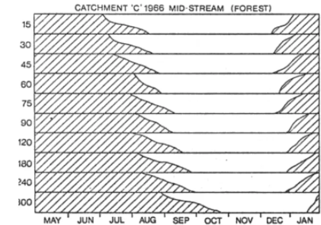
particular environment of the Mbeya Range with its unimodal rainfall pattern, six-month dry season and volcanic ash-derived soils. Unsurprisingly, the evergreen rainforest was found to use significantly more water (122% Et) than the seasonal maize, sorghum and beans grown by the peasant farmers (86% Et). As shown by the gypsum block profiles in Fig. 4, moisture extraction in the cultivated catchment did not occur much beyond 120 cm and had effectively ceased by September in 1966 whereas the forest continued to extract water from depths to 300 cm and beyond throughout the year. It had been anticipated that the combination of steep slopes (up to 30°) and minimal soil conservation measures would result in very high storm runoff and erosion rates, particularly during the first rains after the dry season. In fact, the storm runoff was only marginally higher than that from the forested catchment, reaching a mere 3.5% of rainfall at intensities of 60 mm h1
; soil losses, though much higher than those from the forested catchment, were not unusual at less than eight tonnes ha
¹ yr
¹. Because the infiltration to the soil profile was only fractionally less than that under the forest, the shallow root range of the seasonal crops ensured that the input to recharge the groundwater was greater, resulting in dry season baseflow that was significantly higher than that from the forested catchment. This unexpected result is attributable to the high porosity and remarkable stability of these ash-derived soils and could not be expected to apply on similar slopes elsewhere. That the annual water use of the forested catchment was comparable to that of the forest at Kericho, despite receiving negligible rainfall for seven months each year, suggested a moisture storage capacity of at least 600 mm within the forest root range.
Whilst this result did nothing to strengthen the forest departments case for conservation of the indigenous forest on the basis of protecting water resources, after ten years of cultivation with only crop residues as fertiliser the yields
39 from the experimental catchment had fallen so low that the
farmers were seeking to abandon the area. In retrospect, the incorporation of systematic monitoring of nutrient status would have been a valuable addition to the study.
The Atumatak study of rangeland restoration yielded relatively little in terms of quantitative hydrological results because of the problems with the streamflow structures. As Figs. 1 and 2 indicate, water use was limited by the sparse rainfall and high potential demand. Nevertheless, the gypsum block profiles demonstrated a recovery in infiltration rates after cattle exclusion and bush clearance. This encouraged the rapid re-colonisation of the soils by grasses and herbs which in turn further improved the infiltration rates. As a result, storm flood peaks and sediment loads were reduced significantly. No conclusive evidence of the continuation of this trend under the imposed controlled grazing scheme was obtained in the short time before the study had to close, mainly as a result of the local penchant for cattle theft and tribal skirmishes.
Very soon thereafter a breakdown of law and order in Northern Uganda made the exercise somewhat academic. Local tribes and their herds were devastated by war and diseases and, perversely, much of the savannah became green again.
In some cases, these East African studies produced results of practical relevance to the area of concern whilst, in others, social, political or economic events had overtaken the original objectives. Scientifically, all the studies produced some valuable data and information but, inevitably, left many questions unanswered. Had the resources been available, present day expertise in instrumentation and process studies would have enhanced their contribution to the general understanding of land use hydrology.
UK STUDIES
Taken together, the results of the UK studies of afforestation effects can be summarised thus:
(1) Upland grassland uses water at the Penman Et rate except during very dry summer periods when sufficiently large soil moisture deficits develop to curtail transpiration, or during winter periods when temperatures drop low enough for the grass to become dormant.
(2) Closed canopy conifer forest will use water at a rate in excess of Penman Et because the depth and aerodynamic roughness of the canopy results in significant interception of incoming rainfall and its rapid evaporation back to the atmosphere. The energy and water vapour exchange mechanisms work much more
efficiently than over relatively smooth grassland especially in high windspeed conditions and result in considerable additional water loss. The high annual rainfall and long duration low intensity storms at Plynlimon mean that the forest canopy is wet for much of the time, providing ideal conditions for evaporation of intercepted water. Overall, forest evaporation during the closed canopy, peak growth period was found to be about 1.82.0 times that from grassland (Marc and Robinson, 2007). For the 67% forested catchment during this period, the AE/Et ratio was 1.27 (Table 1).
(3) Young forest will use water at some intermediate rate between that of the preceding vegetation and closed canopy forest. No definitive process results have yet been published on the rates of transition from one to the other. The Coalburn catchment results, however, seem to indicate that the water use remains well below the closed canopy rate for at least the first 15 years, at UK upland growth rates (Robinson, 1986).
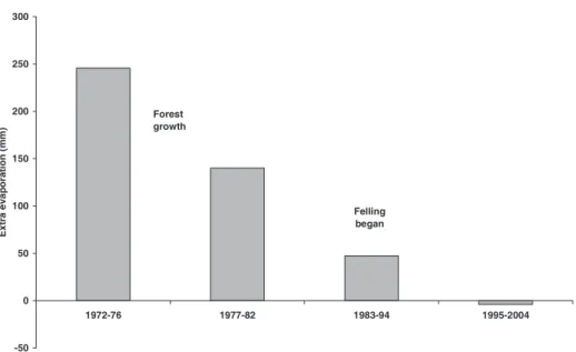
(4) From full canopy closure there is a period of peak water use but, as the forest approaches maturity, the overall water use appears to decrease (Marc and Robinson, 2007) as shown in Fig. 5 and Table 1. This conclusion from the catchment studies is consistent with recent process studies which have reported that increasing tree age leads to reductions in leaf area index and stomatal and canopy conductances (e.g. Ryan et al., 2000).
(5) The other major type of upland vegetation in the UK is heather. Process studies have found that the water use of heather can be either higher or lower than Penman Et. The basic transpiration rate is 0.50.6 Et, and the interception loss rate is higher than grass but lower than that from forest (Hall, 1987).
The knowledge obtained from the process studies has enabled a wide variety of mathematical models to be developed and tested on the catchment data to simulate the effects of afforestation on water use and on streamflow and hence on water resources. These ranged from the relatively simple techniques typified by the Calder and Newson (1979) annual water use approach to the much more comprehensive process-based daily water use models developed by Hall and Harding (1993).
water use by the forest in the early growth stages of the first rotation crop, far from being greater than Et, may be significantly lower depending on the pre-planting ground preparation; the latest results from Plynlimon show a marked decline in water use in the later stages of forest growth. In a large catchment over complete cropping cycles, whether this will result in a net increase or a decrease in streamflow will depend on the spread of crop ages. Continuation of the catchment monitoring at Plynlimon, Coalburn and Balquhidder, together with some process studies on both first and second rotation crops at the intermediate growth stages, should shed further light on this aspect of water use.
PRINCIPAL FINDINGS
The East African and UK catchments provided a number of physical contrasts in terms of climate, soils ad vegetation. They also differed in the direction of change; in East Africa indigenous forest was cleared for cultivation whilst in the UK grazing land was being turned over to commercial forestry.
At Kericho, mature indigenous forest was replaced over a number of years by tea plantations. The clearance and planting of 55% of the treated basin resulted in a reduction in evaporation of over 15% compared with the control forest catchment. Subsequently, the evaporation from established tea estate was about 10% lower than that from forest, which was not unexpected given the very smooth canopy of the clipped tea plants. (see Plate 2).
At Kimakia, the control catchment comprised mountain bamboo which although classified botanically as a grass,
can grow to a dense forest 15 m or higher and with stems up to 15 cm diameter, comparable in size to small trees. Evaporation from the pine seedlings, initially intercropped with vegetables, was at least 10% lower than the bamboo but increased as the pines grew and eventually became equivalent to that of the bamboo.
At Mbeya, seasonal cultivation with a long dry season fallow period gave substantially lower evaporation than the native evergreen forest. At all three sites the land-use changes did not result in any significant changes in storm runoff and sediment yields on the stable, highly porous volcanic soils.
The overall conclusions from these East African catchments were therefore that the alternative land uses did not pose a water resource problem for downstream users.
In the UK studies, there was concern that afforestation would increase water use and so reduce recharge to groundwater and river flows. Observations at Plynlimon showed that evaporation losses from the forested catchment were more than 50% higher during the period of peak growth although rates reduced somewhat over time as the trees approached maturity. Work at Plynlimon, and notably at Thetford, showed conclusively that the higher evaporation from the forest was a result of the greater canopy roughness and air turbulence which led to a much higher rate of evaporation of rainwater intercepted by the tree canopy. The enhancement of forest evaporation (compared with Penman determinations) is much greater from conifers at a temperate site, such as Plynlimon, than that from an East African conifer forest where wind speeds are lower and rainfall is more concentrated in short, sharp showers. Felling of the -50
0 50 100 150 200 250 300
1972-76 1977-82 1983-94 1995-2004
Ex
tr
a
e
v
a
p
or
a
ti
on
(m
m
)
Felling began Forest
growth
forest at Plynlimon resulted in reduced evaporation and a large proportional increase in stream baseflow but had a negligible impact on peak flows.
The overall conclusions from the UK catchments are therefore that afforestation did potentially lead to a reduction in water resources and, as a consequence, restrictions have been placed on the large-scale planting of trees in sensitive areas, including the gathering grounds of reservoirs.
The UK results led to the development of a number of physically-based evaporation models to represent the water use of different vegetation types. These models have also been applied successfully to data from other areas including the East African catchments (Roberts and Harding, 1996). The East African data have also been used in the testing and development of a rainfall-runoff model (Littlewood, 2002).
Lessons for future studies
Catchment studies need to have a purpose or goal not just idle curiosity. In comparing the Plynlimon study with the development of a complex hydrological model, Clarke (2005) considers the former to have been highly successful and having a lasting influence on hydrological research whilst the latter was less successful. He attributes its success to the fact that the scientific issue addressed namely the comparative water use of forest and pasture is a real practical concern about the consequences for the national economy of too little water.
Scientists need to have close links to relevant stakeholders and institutions to ensure that the objectives and methodology actually tackle the questions posed so that the results are taken up. The high rainfall East African studies would not have been possible without the active participation of the relevant government departments and, at Kericho, the relevant commercial sector. At Atumatak, the failure of the agriculture department to obtain the trust and cooperation of the local tribes was a factor in the limited success of the study. Similarly in the UK, the active participation of the Forestry Commission, the river authorities and, at Plynlimon and Balquhidder, the local farmers, was essential for the success of the studies.
For long-term catchment studies that are planned to run for 20 years or more, the socio-economic conditions that gave rise to them may change considerably. In Kenya the change in emphasis in tea production from large-scale estates to small farm cash cropping has rendered the Kericho results largely academic. In the case of Plynlimon, the greater water use of commercial forestry in the uplands was generally accepted and quantified within limits by the end of 1970s and attention then turned to aspects of water quality
(including long-term acidification and to nutrient pulses due to felling). There is now a greater awareness of the need for an integrated and holistic approach including agricultural production and environmental/ecological considerations.
These studies have highlighted the importance of studying and understanding what happens immediately after a land-use change and before the new cover stabilises. Thus, in the case of the forest clearance at Kericho, water use was depressed only marginally. Clearance of the evergreen montane rainforest was carried out block by block, followed immediately by tea planting and sowing of oat crops as soil protection in the early stages of tea growth. In contrast, at Kimakia, after the bamboo was cleared, there was a large increase in flows as the whole area to be planted was clean weeded and seasonal vegetables were grown for the first three years among the young pines. At Coalburn in UK, planting was preceded by the cutting of a dense network of drainage furrows and ditches. The high percentage area of bare soil exposed and the de-watering effect of the ditches resulted in a large apparent reduction in water use until regeneration and tree growth restored ground cover and the water table stabilised at a lower level.
Quality control of data and field checking of instrumentation performance must be continuous, ongoing operations running in parallel with analysis and modelling. As the data run lengthens, it becomes progressively easier to identify trends or discontinuities and trace the reasons for them. As examples, an apparent downward trend in water use of the bamboo catchment at Kimakia was eventually traced to the sinking, by a few mms, of the reference level against which the water level recorder was checked and set whilst discontinuities in the Penman estimates at Kericho were traced to minor differences in the mountings of successive Gunn Bellani radiation instruments. Similarly, many problems with streamflows and with the precipitation data at Plynlimon were identified, traced and corrected.
It is essential to run a study for long enough to detect changes in response with time. This applies particularly where the crop of interest is an even aged monoculture. As is becoming apparent at Plynlimon, there can be significant changes in water use not just in the early stages of growth but also in the final run up to maturity.
as they deserved. In contrast, papers on the Plynlimon study have been published widely in the international literature, have attracted much useful comment and led to changes in forestry practices.
FUTURE CATCHMENT WORK
Catchments have been studiedextensively because at the outlet they provide an integration of all the inputs to the area and the processes that have occurred. Water and chemical balances can be quntified for watertight basins. Only at the catchment scale can changes in streamflow regimes be observed. At the time of the inception of the East African and Plynlimon catchments there was no way to measure evaporation areally. It had to be estimated as the residual from a catchment water balance, and the only check possible was comparison with potential evaporation estimated from meteorological variables. Increasingly, developments in micrometeorological techniques such as eddy covariance (e.g. Marc and Robinson, 2007) and scintillometry (e.g. de Bruin et al., 2002) are enabling hydrologists to break free from the constraints of catchments and to consider individual hillslopes or whole landscapes.
Acknowledgements
The guiding hand in the planning, implementation, expansion and continuation of these studies has been that of Jim McCulloch. As has been indicated in the text, the studies could not have been carried out without the backing and active involvement of a wide range of government departments and landowners in both East Africa and the UK. The unsung heroes however are the field observers without whose dedication to their tasks in remote locations and often difficult weather and security conditions nothing would have been achieved.
References
Ackermann, W. S., 1966. Guidelines for research on the hydrology of small watersheds. Office of Water Resources, US Dept. of Interior, Washington DC, USA. 26pp.
Bates, C.G. and Henry A.J., 1928. Forest and streamflow experiment at Wagon Wheel Gap, Colorado. Monthly Weather Review, Supplement 30, U.S. Dept. Agriculture, Weather Bureau. 79pp.
Bell, J.P., 2005. Soil hydrology of the Plynlimon catchments. Institute of Hydrology Report No 8. (Revised). Centre for Ecology and Hydrology. Wallingford. UK. 50pp.
Bell, J.P. and McCulloch, J.S.G., 1969. Soil moisture estimation by the neutron method in Britain. J. Hydrol., 7, 425433. Blackie, J.R., 1979. The water balance of the Kericho catchments.
E. Afr. Agr.. Forest. J., 43, Special Issue, 5584.
Blackie, J.R., 1987. The Balquhidder catchments, Scotland: the first four years. Trans. Roy. Soc. Edinburgh, Earth Sci., 78, 227 239.
Blackie, J.R., 1993. The water balance of the Balquhidder catchments. J. Hydrol., 145, 239257.
Blackie, J.R., Edwards, K.A. and Clarke, R.T., 1979. Hydrological Research in East Africa. E. Afr. Agr. Forest. J., 43, Special Issue, 313pp.
Calder, I.R., 1976. The measurement of water losses from a forested area using a natural lysimeter. J. Hydrol., 30, 311 325.
Calder, I.R. and Newson, M.D., 1979. Land use and upland water resources - a strategic look. Water Resour. Bull. 16, 16281639. Callander, B.A. and Woodhead, T., 1979. Eddy correlation measurements of convective heat flux and estimation of evaporative heat flux over growing tea. E. Afr. Agr. Forest. J.,
43, Special Issue, 85101.
Clarke, R.T., 2005. The PUB decade: how should it evolve?
Hydrol. Process. J., 19, 28652889.
Clarke, R.T. and Newson, M.D., 1978. Some detailed water balance studies of research catchments. Phil. Trans. Roy. Soc. Lond., A 363, 2142.
Cooper, J.D., 1979. Water use of a tea estate from soil moisture measurements. E. Afr. Agr. Forest. J., 43, Special Issue, 102 121.
Dagg, M., 1970. A study of the water use of tea in East Africa using a hydraulic lysimeter. Agr. Meteorol., 7, 303320. Dagg, M. and Pratt, M.A.C., 1962. Relation of stormflow to
incident rainfall. E. Afr. Agr. Forest. J., 27, Special Issue, 313. Edwards, K.A., 1979. The water balance of the Mbeya experimental catchments. E. Afr. Agr. Forest. J., 43, Special Issue, 231247.
Edwards, K.A. and Blackie, J.R., 1981. Results of the East African catchment experiments, 1958-74. In: Tropical Agricultural Hydrology, R. Lal and E.W.Russell (Eds.), Wiley, New York, USA. 163188.
Eeles, C.W.O. 1979. Soil moisture deficits under montane rain forest and tea. E. Afr. Agr. Forest. J., 43, Special Issue, 128 138.
Glover, J. and McCulloch J.S.G., 1958. The empirical relationship between solar radiation and hours of bright sunshine in the high altitude tropics. Quart. J. Roy. Meteorol. Soc., 84, 5660. Hall, R.L., 1987. Processes of evaporation from vegetation of the
uplands of Scotland. Trans. Roy. Soc. Edinburgh, Earth Sci.,
78, 327334.
Hall, R.L. and Harding, R.J., 1993. The water use of the Balquhidder catchments: a process approach. J. Hydrol., 145, 285314.
Hudson, J.A., Crane, S.B. and Robinson, M., 1997. The impact of the growth of new plantation forestry on evaporation and streamflow in the Llanbrynmair catchments. Hydrol. Earth Syst. Sci., 1, 463475.
Johnson, R.C., 1990. The interception, throughfall and stemflow in a forest in highland Scotland and the comparison with other upland forests in the UK. J. Hydrol., 118, 281287.
Keller, H.M., 1988. European experiences in long term forest hydrology research. In: Forest Hydrology and Ecology at Coweeta, W.T.Swank and D.A.Crossley (Eds.), Ecological Studies No 66, Springer-Verlag, New York. 407459. Law, F., 1956. The effect of afforestation upon the yield of water
catchment areas. J. Brit. Waterworks Assoc., 38, 484494. Law, F., 1957. Measurement of rainfall, interception and
evaporation losses in a plantation of Sitka Spruce trees. IAHS Publication no.44, 397411.
McCulloch, J.S.G., 1962. Measurements of rainfall and evaporation. E. Afr. Agr.. Forest. J., 27, Special Issue, 8892. McCulloch, J.S.G., 1965. Tables for the rapid computation of the
Penman estimate of evaporation. E. Afr. Agr. Forest. J., 30, 286 295.
McCulloch, J.S.G., 1970. Catchment area research. Proc. Inst. Civil Eng., 47, 461463.
Marc, V. and Robinson M. 2007. Assessing the long-term water balance of upland grassland and forestry at Plynlimon, mid-Wales. Hydrol. Earth Syst.Sci., 11, 4460.
Meadows, D.H., Meadows, D.L., Randers, J. and Behrens III, W.W., 1972. The Limits to Growth, Universe Books, New York, USA. 208pp.
Monteith, J.L., 1965. Evaporation and environment. Symp. Soc. Exp. Biol., 19, 205234.
Neal, C. and Rosier, P., 1990. Chemical studies of chloride and stable oxygen isotopes in two conifer afforested and moorland sites in the British uplands. J. Hydrol., 115, 269283. Neal, C., Robson, A.J., Shand, P., Edmunds, W.M., Dixon, A.J.,
Buckley, D.K., Hill, S., Harrow, M.L., Neal, M. and Reynolds, B., 1997. The occurrence of groundwater in the Lower Palaeozoic rocks of upland Central Wales. Hydrol. Earth Syst. Sci., 1, 318.
Painter, R.B., Rodda, J.C. and Smart, J.D.G., 1972. Hydrological research and the planner. Surveyor, 140, 2225.
Penman, H.L., 1948. Natural evaporation from bare soil, water and grass. Proc. Roy. Soc. Lond., A 193, 120145.
Penman, H.L. 1963. Vegetation and Hydrology. Tech. Comm. 53, Commonwealth Bureau of Soils, Harpenden, UK. 124 pp. Pereira, H.C., 1951. A cylindrical gypsum block for moisture
studies in deep soils. J. Soil Sci., 2, 212223.
Pereira, H.C., 1959. Practical field instruments for the estimation of radiation and of evaporation. Quart. J. Roy. Meteorol. Soc.,
85, 253261.
Pereira, H.C. et al., 1962. Hydrological effects of changes in land use in some East African catchment areas. E. Afr. Agr. Forest.
J. 27. Special Issue, 131pp.
Roberts, G. and Harding, R.J., 1996. The use of simple process based model in estimate of water balalnces for mixed land use catchments in East Africa. J. Hydrol., 180, 251266.
Roberts, G., Hudson, J.A. and Blackie, J.R., 1984. Nutrient inputs and outputs in a forested and a grassland catchment at Plynlimon, mid-Wales. Agr. Water Manage., 9, 177191.
Robinson, M., 1980. The effect of pre-afforestation drainage on the streamflow and water quality of a small upland catchment.
Institute of Hydrology Report No. 73, Wallingford, UK. 69pp. Robinson, M., 1986. Changes in catchment runoff following
drainage and afforestation. J. Hydrol., 86, 7184.
Rodda, J.C., 1967a. The rainfall measurement problem. IAHS Publication No. 78, 215231.
Rodda, J.C., 1967b. The systematic error in rainfall measurement.
J. Inst. Water. Eng,. 21, 173177.
Ryan, M.G., Bond, B.J., Law, B.E., Hubbard, R.M., Woodruff, D., Cienciala, E. and Kucera, J., 2000. Transpiration and whole-tree conductance in ponderosa pine whole-trees of different heights.
Oecologia, 124, 553560.
Stewart, J.B., 1977. Evaporation from the wet canopy of a pine forest. Water Resour. Res. 13, 915921.
Strangeways, I.C., 1972. Automatic weather stations for network operation. Weather, 27, 403408.
Strangeways, I.C. and McCulloch, J.S.G., 1965. A low priced automatic hydrometeorological station. IAHS Bull., 10, 5762. Swank, W.T. and Crossley, D.A. (Eds.), 1988. Forest Hydrology and Ecology at Coweeta. Ecological Studies No 66. Springer-Verlag, New York. 469pp.
Wangati, F.J. and Blackie, J.R., 1971. A comparison between lysimeter and catchment water balance estimates of evapotranspiration from a tea crop. In: Water and the Tea Plant, M.V.K. Carr and S. Carr(Eds.), Tea Research Inst. of East Africa, Kericho, Kenya. 920.
UKAWRG, 1988. Acidity in the United Kingdom fresh waters. Second report. UK Acid Waters Review Group. HMSO. London. 61pp.
Wicht, C.L., 1966. Trends in forest hydrological research. S. Afr. Forest. J., 57, 1725.