19 http://biology.num.edu.mn
http://mjbs.100zero.org/ Volume 11(1-2), 2013
Mongolian Journal of Biological
Sciences
ISSN 2225-4994 (online edition)
MJBS
Original Ar• cle
Creating a Ruggedness Layer for Use in Habitat
Suitability Modeling for Ikh Nart Nature Reserve,
Mongolia
Nanette Bragin
1, Navinder J. Singh
2and Richard P. Reading
11Department of Conservation Biology, Denver Zoological Foundation, 2300 Steele Street, Denver, CO 80205
USA E-mail: [email protected]; [email protected]. FAX: 720-337-4801
2Department of Wildlife, Fish and Environmental Studies, Swedish University of Agricultural Sciences,
Umeå, Sweden, 90183. E-mail: [email protected]
Abstract
Key words: ruggedness, habitat modeling, Ikh Nart, SARI, aspect, slope, GIS
Article information:
Received: 13 Jul. 2013 Accepted: 15 Jan. 2014 Published: 20 Apr. 2014
Correspondence: [email protected] Cite this paper as:
Spatially-explicit wildlife habitat models are increasingly used to study optimal habitat for species of conservation focus. A ruggedness layer, that summarizes aspect and slope, provides a useful tool for analyses conducted in a Geographic Information System (GIS), such as developing a habitat suitability index model to measure species habitat use. Ruggedness layers prove especially useful in areas where topography represents a key habitat component. We created a ruggedness layer for the Ikh Nart Nature Reserve and surrounding areas in northern Dornogobi Aimag (province), Mongolia. Using a 90 m Shuttle Radar Topography Mission (SRTM) digital elevation model (DEM) and ArcGIS 10 spatial analyst, we created 9 categories for ruggedness. When combined with other thematic layers such as vegetation, the ruggedness layer becomes a powerful tool for analyzing habitat use by individual animals. The results of such analyses may inform decision makers in protected area planning and conservation of endangered species.
Bragin, N., Singh, N. J. & Reading, R. P., 2013. Creating a ruggedness layer for use in habitat suitability modeling for Ikh Nart Nature Reserve, Mongolia. Mong. J. Biol. Sci., 11(1-2): 19-23.
Introduction
Spatially-explicit wildlife habitat models are important tools for conservation planning. Models can determine habitat conservation priorities, determine suitability of habitat for reintroduction of endangered species, understand the impact of land management decisions, and identify potential risks to species (Yamada et al., 2003). Using a Geographic Information System (GIS), a model can spatially examine the interactions between a species and its environment. Widely used in habitat modeling, a Habitat Suitability Index Model (HSIM) uses an index scale to rate appropriate and inappropriate habitat for a species (Yamada et al., 2003).
Topography can represent an important
variable in analyzing habitat use. Slope, aspect, deposition of snow and patterns generated, rainfall and watersheds, vegetation growth, and cover from predators depend on the topography of an area (Nellemann & Fry, 1995). Many species that inhabit rugged and mountainous terrain depend on the topography of the landscape to fi nd food and cover from predators. In such areas, ruggedness becomes an important topographic variable. The presence of rocky outcrops, steep cliffs, and rolling hills may characterize the ruggedness of an area. However, such characteristics are diffi cult to map and measure.
interest to create a set of classes ranging from the least to most rugged. Such a layer often proves useful in developing a HSIM. We created a ruggedness index to help us assess habitat use and create HSIMs for the wildlife of Ikh Nart Nature Reserve.
Study Area
The Mongolian government established Ikh Nart Nature Reserve (hereafter Ikh Nart) in 1996 to protect about 66,760 ha of northwestern Dornogobi Aimag (N45.723°, E108.645°, Fig. 1). Ikh Nart includes steppe and desert-steppe habitats, with a strongly continental and arid climate (Reading et al., 2011). Temperatures
range from -40°C to 43°C. Strong winds in the spring may reach 25 mps. Low humidity and precipitation typify the region, with most rain falling in the summer (<100 mm/year) (Bragin, 2010). Water draining the reserve provides a few, permanent, cold water springs. Ephemeral drainages and creek beds, alkaline pools, and ponds also occur in the reserve (Wingard, 2005; Reading et al., 2007; Jackson et al., 2006). Our study site encompassed the northern portion of Ikh Nart Reserve and immediately surrounding area (Fig. 2). The study site, bounded by latitude of N45.83°-N45.54°; E108.48°-E108.73°, comprises 72,937 ha. We based the extent on a previous study for vegetative habitat classifi cation
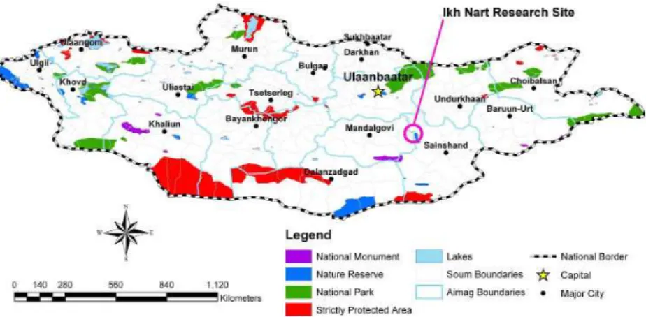
Figure 1. Map of Mongolia’s Reserves and indicator for the Ikh Nart Reserve.
Figure 2. Study site, Ikh Nart Reserve, and core zone.
in Ikh Nart and the surrounding areas (Jackson et al., 2006).
Methods
with a value of 3 map values (1 map value = 1 cell = 81 m) to match the habitat choice made by mountain ungulates occurring in the study area at the feeding patch scale within the landscape
(Sappington et al., 2007). A moving window averages elevation values to create a continuum of ruggedness (Danks & Klein, 2002).
We created the slope aspect ruggedness index (SARI) using Spatial Analyst, Math Algebra, Raster calculator, and based the calculation for terrain ruggedness on a modifi ed version of Nellemann and Fry 1995 (Nielsen et al., 2001; Singh et al., 2009):
SARI=(STDEV Slope) x Variety of Aspect/ (STDEV Slope) + Variety of Aspect.
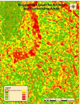
The resulting layer produced ruggedness values ranging from 1 = least rugged to 9 = most rugged (Fig. 6).
Results
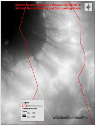
Moderate terrain ruggedness (SARI=5) is most prevalent in the study area comprising twenty percent. SARI classes fi t a relatively normal distribution with least rugged classes (1-4) and most rugged classes (6-9) dropping in percent area occupancy. Even though there is a uniform drop in area occupied, the more rugged classes occupy relatively less area than least rugged, 4.29 % for SARI classes 8 and 9; 11.49% for SARI classes 1 and 2 (Table 1). Further, the most rugged classes 6-9 occupy 33.69% while the least rugged SARI Figure 3. Shuttle Radar Topography Mission (SRTM)
90 m digital elevation model of study area
Figure 4. Derived slope layer from SRTM
classes 1-4 occupy 45.53% of the landscape. As we expected, the most rugged areas occurred at the edge of the uplifted region of the reserve, where it falls to far more level areas surrounding the uplift, but especially to the relatively fl at basin in the northwest. As we travel south, the reserve becomes fl at entering the core of the Gobi desert with fewer rocky outcrops. This coincides with the higher percentage of less rugged areas in our map.
Discussion
Ruggedness measures the slope and aspect of an area and infl uences species habitat preference (Nellemann & Fry, 1995). The Slope and Aspect Ruggedness Index (SARI) measures the steepness (fl uctuation in elevation) of terrain combined with the total number of fl uctuations in aspect, undulations, or “uphills” and “downhills” (Nellemann & Reynolds, 1997). The most rugged terrain refl ects many changes in relief, steeper slopes, and considerable fl uctuations in aspect. Ruggedness infl uences temperature, water drainage, soil composition, and vegetation. Ruggedness may provide hollows for denning and protection from climate and predators. For example, an area with high variability in slope and aspect may produce microclimates with a higher biomass for foraging. In addition, windblown bluffs, hill tops and ridges allow greater access to snow covered forage than densely snow covered plains.
Some our main species focus in Ikh Nart include Argali sheep (Ovis ammon),and Siberian ibex (Capra sibirica). Our efforts in understanding their ecology use many tools. For example, we have thousands of location data and have analyzed home range area. But, our next step encompasses overlaying vegetation, ruggedness, and home range layers to fully understand how argali and ibex utilize the landscapes they inhabit. We can use ruggedness with other variables to conduct more complete studies of species’ habitat use. Vegetation, home range area, prey and predator base, and behavior profi les combined with ruggedness provide a more complete indication Figure 6. Ruggedness layer of Ikh Nart and
Surrounding areas. Aspect and slope were combined to create an index from 1=least rugged to 9=most
rugged
Table 1. Table of Slope Aspect Ruggedness Index (SARI) values. SARI = index of ruggedness values from 1-9 with 1 = least rugged and 9 = most rugged. Cell Count = number of cells with a SARI value. Area = sum of area
of the cells of a SARI value. % = percent of areas covered by a SARI value.
SARI Cell Count Area (ha) %
1 285 1142.32 1.50
2 1357 7590.20 9.99
3 3415 11912.10 15.67
4 4714 13962.31 18.37
5 4660 15762.53 20.74
6 3544 13626.23 17.93
7 1765 8717.18 11.47
8 585 2532.05 3.33
of species’ habitat preference. Once completed, a profi le overlaid in other areas of Mongolia may inform decision makers of the best habitat in similar ecosystems for preservation. We further recommend replicating this work for populations inhabiting other ecosystems of Mongolia, such as the high Altai Mountains. We can also use these methods for other species in Ikh Nart.
Scale and resolution produce different results when analyzing spatial data. Nelleman and Fry (1995) found that fi ne-scale analyses using maps with 10-20 m contours showed a relationship between potential feeding locations and ruggedness, whereas contours of 30-110 m maps did not. When digital terrain maps (DTMs) become available at 20 m resolution or higher, a combination of terrain ruggedness, vegetation, and DTM layers can automatically analyze habitat use and the infl uence of ruggedness through advanced software. Analyzing rugged terrain at a fi ne scale and resolution can detect micro-climates and ecosystems that previously remained unapparent. Also, this method detects subtle differences in relatively smooth terrains such as plains. But, depending on the objective, large scale and coarse resolution layers have been used to determine landscape eco-tones that assist in focusing on priority ecosystems (Eide et al., 2001). Fine scale classifi cations of ruggedness may confound analysis. When a species exhibits a preference for a large range of ruggedness values, it may be useful to lump several classes together.
Understanding optimal habitat for wild fl ora and fauna can inform planners and managers on park health in a protected area system. One tool useful in determining optimal habitat is a Habitat Suitability Index Model. Combining useful layers, such as vegetation and ruggedness, in a spatial model can create a HSIM to help discover if designated protected areas are designed appropriately, offering wildlife species optimal habitat.
References
Bragin, N. 2010. Creating a Habitat Suitability Index model for Argali sheep (Ovis ammon), and Siberian ibex (Capra sibirica) in Ikh Nartin Reserve, Mongolia. Master Thesis, Denver University, pp. 1-57.
Danks, F. S. & Klein, D. R. 2002. Using GIS to predict potential wildlife habitat: a case study of muskoxen in Northern Alaska. J. Remote
Sensing, 23(21): 4611-4632.
Eide Nina, E., Nellemann, C. & Prestrud, P. 2001. Terrain structure and selection of denning areas by arctic foxes on Svalbard. Polar Biology, 23: 132-138.
Jackson, D. S., Murdoch, J. & Mandakh, B. 2006. Habitat classifi cation using Landsat 7ETM+ imagery of the Ikh Nart nature reserve and surrounding areas in Dornogobi and Dundgobi Aimags, Mongolia. Mongolian Journal of Biological Sciences,4: 33-40.
Nellemann, C. & Fry, G. 1995. Quantitative analysis of terrain ruggedness in reindeer winter grounds. Arctic, 48: 172-176.
Nellemann, C. & Reynolds, P. E. 1997. Predicting late winter distribution of muskoxen using an index of terrain ruggedness. Arctic and Alpine Research, 29:334-338.
Nielsen, S. E., Herrero, S., Boyce, M. S., Mace, R. D., Benn, B., Gibeau, M. L. & Jevons, S. 2004. Modelling the spatial distribution of human-caused grizzly bear mortalities in the Central Rockies ecosystem of Canada. Biological Conservation, 120: 101-113.
Reading, R. P., Amgalanbaatar, S., Kenny, D., DeNicola, A. & Tuguldur, E. 2007. Siberian Ibex (Capra [ibex] sibirica) home ranges in Ikh Nart nature reserve, Mongolia: Preliminary fi ndings. Mongolian Journal of Biological Sciences, 5(1-2):29-37.
Reading, R. P., Kenny, D. & Steinhauer-Burkhart, B. 2011. Ikh Nature Reserve Nature Guide No. 4 Mongolia. ECO Nature Edition, Steinhauer-Burkart OHG., pp. 1-64.
Sappington, M. J., Longshore, D. K. & Thompson, D. B. 2007. Quantifying landscape ruggedness for animal habitat analysis: a case study using bighorn sheep in the Mojave Desert. The Journal of Wildlife Management, 71: 1419-1426.
Singh, N. J., Yoccoz, N. G., Bhatnagar, Y. V. & Fox, J. L. 2009. Using habitat suitability models to sample rare species in high-altitude ecosystems: a case study with Tibetan argali. Biodivers. Conserv., 18: 2893-2908.
Wingard, G. J. 2005. Dietary overlap between Argali sheep and domestic livestock in Mongolia. Master Thesis, University of Montana, 1-64.