21
Methane distribution in Holocene marine sediments in
the Bornholm Basin, southern Scandinavia
Jørn Bo Jensen and Rudolf Endler
The Baltic Sea is an ideal natural laboratory to study the methane cycle in the framework of diagenetic processes. In this paper we present preliminary geological mapping results from project Baltic Gas, a research project with the overall aim to contribute to the development of a scientific basis for long term sustainable use and protection of the Baltic Sea ecosystem. The Baltic Sea is a marginal sea with a strong permanent haline stratification, which leads to oxygen-poor bottom waters, and which is sometimes interrupted by oxy-gen-rich saltwater flowing in from the North Sea. The histo-ry of the Baltic Sea has resulted in deposition of organic-rich Holocene marine sediments that overlie glacial, late-glacial and early Holocene organic-poor sediments.
The aims of Baltic Gas, a project within the BONUS-169 Joint Baltic Sea Research Programme running from 2009 to 2011, were (1) to map the occurrence of free shallow gas in Holocene sediments, (2) to quantify methane fluxes through the sediments and into the water column and the atmosphere, and (3) to investigate the processes and parameters governing methane generation and consumption. The contribution by the Geological Survey of Denmark and Greenland, reported here, was to map the thickness and structure of organic-rich marine deposits and the distribution of gas-bearing
sediments in co-operation with partners. The authors have also compiled acoustic data which were used to select sites for a comprehensive coring programme. The sediment cores were used for physical characterisation of the gas-bearing sediments and for biogeochemical analyses. These included measurements of the concentrations of methane, sulphide, sulphate, iron and other elements and compounds. Here we present data from the Bornholm Basin, one of several key study areas (Fig. 1).
Methods
On shallow seismic profiles, the acoustic return signal is re-duced in areas rich in gas-bearing sediments. The most pro-nounced reduction is seen when the frequency used during the seismic survey is near the resonance of the gas bubbles. Their size controls the resonance frequency, and multi-fre-quency data from the project show maximum bubble reso-nance close to 4.2 kHz, which indicates gas bubbles with a radius of 0.5–2 mm. Many of the acoustic/gas relationships were established by Anderson & Hampton (1980a, b).
Acoustic data acquired during the project comprised swath bathymetry data, multibeam backscatter data,
multi-Fig. 1. Map of the Baltic Sea region showing the location of the project Baltic Gas in the Bornholm Basin (red rectangle) and the location of other place names mentioned in the text. 1: Eckernförder Bucht, 2:
Mecklen-burger Bucht, 3: Arkona Basin.
Fig. 2. Map of the Bornholm Basin showing the distribution of shallow seismic lines and deep faults. The location of the seismic profile of Fig. 5 is shown in green.
Baltic Sea
Sweden Norway
Denmark
500 km Poland
North Sea
1 2
3
10 km 15°E
55°10´N Seismic line Profile in Fig. 5 Fault
22 22
frequency single beam data (5–100 kHz), echo sounder data as well as high frequency seismic data. Sediment acoustic work using a 5–100 kHz signal was mainly carried out in areas known to be rich in gas at shallow depths in Mecklen-burger Bucht, the Arkona Basin and the Bornholm Basin in the western Baltic. Data from Parasound and an Innomar sediment echo sounder were acquired simultaneously for all acoustic lines. Extensive seismic data were acquired from the gas-rich part of the Bornholm Basin (Figs 1, 2). The sedi-ment acoustic records were used to select places for collec-tion of water-column data and bottom sediments during the cruises. The simultaneous recording with different devices allowed comparison of the different responses to the occur-rence of gas at shallow depths.
The new seismic field data collected during project Baltic Gas was loaded onto a seismic work station and combined with seismic archive data from the same area. The seismic dataset was interpreted and combined with physical charac-teristics of the sediments plus additional seabed data to com-pile a map of the gas distribution in the Baltic Sea. Multi-sensor core logging of 6–12 m long gravity cores were used for estimating the basic physical properties of sediments with and without gas bubbles. Split cores were used for core de-scription, sub-sampling and sedimentological analyses.
Gas distribution mapping in the
Bornholm Basin
As stated in the introduction, the main aim of the project was to produce a map of the seabed gas distribution in the Fig. 3. Model of syn-sedimentary infill in a half-graben.
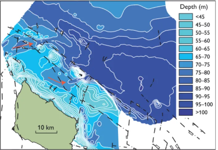
Fig.4. Map of the Bornholm Basin showing the bathymetry and deep faults (black stippled lines). The red arrows show inflow channels.
10 m
Glacial deposits
Bedrock
SW NE
Free gas
5 km Littorina Sea mud
Ancylus Lake clay Yoldia Sea clay Baltic Ice Lake clay
Fig 5. Seismic profile 2005-06222 obtained by an Innomar sediment echo sounder (10 kHz). The profile crosses the Bornholm Basin (for location see Fig. 2). Deposits from the Baltic Ice Lake, the Yoldia Sea and the Ancylus Lake drape the glacial basin surface whereas mud from the Littorina Sea shows asym-metrical infill. Acoustic blanking due to free gas occurs where the thickness of the organic-rich Littorina mud exceeds 6–8 m.
Bottom of basin Basin
Footwall uplift
Border fault
Rivers
Edge of basin
Sediment layers Fault scarp
>100 95–100 90–95 85–90 80–85 75–80 70–75 65–70 60–65 55–60 50–55 45–50 <45
Depth (m)
23
Baltic Sea. Such a map shows only the general pattern, so in order to understand the mechanism of gas production below the seabed it was necessary to make detailed studies in a few key areas. The Bornholm Basin was selected as one of these key areas, because it is well known for gas-rich sediments and because seismic data from previous surveys together with the new data made it possible to get a full coverage of the basin with limited supplementary work during the cruises (Fig. 2).
The Bornholm Basin is located north-east of the island of Bornholm in an area that has been influenced by block faulting. It is possible that faulting continued into the Holo-cene. The Bornholm Basin is bounded by major faults and has been interpreted as a half-graben (Fig. 3; Vejbæk 1985; Wannäs & Flodén 1994; Sviridov et al. 1995) in which thick packages of late glacial and Holocene sediments have been deposited. In spite of the post-half-graben sedimentation his-tory, the present bathymetry clearly reflects the deeper struc-tures (Fig. 4). Two inflow channels are found in the south-eastern part of the basin.
It is a characteristic feature of the basin that late glacial and early Holocene clay deposits drape the glacial surface, whereas the marine Holocene mud sediments form a wedge-like sediment body (Fig. 5). This difference reflects different sedimentation mechanisms, from vertical settling of sedi-ment particles to settling influenced by inflowing currents during the marine Littorina Sea stage.
A map showing the thickness of the Holocene marine mud based on the depth of the seabed and the bottom of the Holo-cene marine mud is shown in Fig. 6. A clear connection be-tween the thickness of the mud and the down-faulted blocks is seen; the mud reaches a thickness of more than 12 m in the vicinity of the fault scarp of the half-graben, but only a few metres in the deepest, central part of the Bornholm Basin.
Acoustic blanking is seen in many seismic profiles. This is caused by scattering due to gas bubbles in the sediment. A gas distribution map has been compiled showing the depth from the seabed to the top of the acoustic gas front (Fig. 7). Experi-ence tells us that a critical thickness of organic-rich Holocene marine mud must be reached before free gas bubbles form. In the Bornholm Basin where water depths in the order of 90 m are found, acoustic blanking starts where the Holocene organic-rich mud reaches a thickness of 6–8 m. The depth from the seabed to the top of the acoustic gas front is an im-portant parameter in modelling methane fluxes. Our study shows that in the Bornholm Basin the gas front is located less than 0.5 m below the seabed, in areas with the highest sedimentation rates of organic-rich mud.
Acoustic properties and physical
characteristics of gas-charged sediments
The data acquired from multi-sensor core logging and sedi-mentological analyses were used for geo-acoustic models and interpretation of the seismo-acoustic records. The physical properties and the geo-acoustical data were used to investi-gate the influence of gas bubbles on the acoustic properties and the strength of the muddy sediments.
The acoustic properties such as sound velocity and attenu-ation are strongly influenced by gas bubbles in the sediments, as illustrated in the sediment echo sounder and seismic re-cords (Fig. 5). The behaviour of acoustic signals is very com-plex and controlled by environmental parameters includ-ing pressure and temperature, the sound frequency and the physical properties of the different sedimentary components (solid grains, water and gas bubbles). The physical proper-ties determined on sediment cores or samples from sediment
Fig. 6. Map of the Bormholm Basin showing the thickness of Holocene marine mud. Deeper structures are represented by the faults (black stip-pled lines).
4.5–5.0 4.0–4.5 3.5–4.0 3.0–3.5 2.5–3.0 2.0–2.5 1.5–2.0 1.0–1.5 0.5–1.0 0.0–0.5
Depth (m)
>5
10 km
Fig. 7. Mapped areas with acoustic blanks caused by scattering due to gas bubbles in the sediment. The depth from the seabed to the top of the acoustic gas front is shown.
>12 10–12 8–10 6–8 4–6 2–4 0–2
Thickness (m)
24 24
samples (wet bulk density, porosity, gravimetric bulk water content, loss on ignition and vane shear strength) showed no significant differences between gas-charged and gas-free mud. The reason may be that gas bubbles only constitute a small part of the sediment and hence do not change the bulk properties significantly. Similar results were reported by Wilkens & Richardson (1998) for Eckernförder Bucht where the gas volume ranged from 0 to 2%, with bubble diameters of 0.6–1 mm.
Concluding remarks
Ma pping of the methane distribution in the Baltic Sea sur-face sediments and sediment analyses have led to a number of conclusions:
1. Acoustic blanking in seismic proi les is caused by scat-tering due to gas bubbles in the sediment. h e bubble size controls the resonance frequency, and the results indicate a maximum bubble resonance close to 4.2 kHz, corresponding to bubble diameters in the order of 1–4 mm.
2. Accumulations of near-surface gas in the Baltic Sea in general are restricted to near-shore archipelagos and geologically controlled sediment traps with high sedi-mentation rates.
3. A direct link between the occurrence of near-surface gas and a minimum thickness of Holocene marine organic-rich sediments is seen. A characteristic feature for the Bornholm Basin is that acoustic blanks are seen where the organic-rich mud reaches a thickness of more than 6–8 m.
4. h e acoustic properties of gas-free and gas-charged sediments are very dif erent, as demonstrated by sound-velocity changes and attenuation in the seismic records. h e behaviour of acoustic signals is extremely complex and inl uenced by environmental parameters such as pressure and temperature.
5. Comparisons of gas-charged and gas-free mud show no signii cant dif erence in bulk properties of various basic physical parameters determined in the sediment. h is may rel ect that gas bubbles only constitute 0–5% of the Holocene muddy sediments.
Acknowledgement
Project Baltic Gas was funded by The Baltic Organisations Network
(BONUS).
References
Anderson, A.L. & Hampton, L.D. 1980a: Acoustics of gas-bearing
sedi-ments I. Background. Journal of the Acoustical Society of America 67,
1865–1889.
Anderson, A.L. & Hampton, L.D. 1980b: Acoustics of gas-bearing sedi-ments II. Measuresedi-ments and models. Journal of the Acoustical Society
of America 67, 1890–1903.
Sviridov, N.I., Frandsen, J.V., Larsen, T.H., Friis-Christensen, V., Madsen, K.E. & Lykke-Andersen, H. 1995: The geology of Bornholm Basin.
Aarhus Geoscience 5, 15–35.
Vejbæk, O.V. 1985: Seismic stratigraphy and tectonics of sedimentary ba-sins around Bornholm southern Baltic. Danmarks Geologiske
Under-søgelse, Serie A 8, 30 pp.
Wannäs, K.O. & Flodén, T. 1994: Tectonic framework of the Hanö Bay area, southern Baltic Sea. Technical Report: Svensk Kärnbränslehante
ring AB, 1994, 50 pp., http://www.skb.se/upload/publications/pdf/
TR94-09webb.pdf
Wilkens, R.H. & Richardson, M.D. 1998: The influence of gas bubbles on sediment acoustic properties: in situ, laboratory, and theoretical
re-sults from Eckernförde Bay, Baltic sea. Continental Shelf Research 18,
1859–1892.
Authors’ addresses
J.B.J., Geological Survey of Denmark and Greenland, Øster Voldgade 10, DK-1350 Copenhagen K, Denmark. E-mail: [email protected]