The European Journal of Spatial Development is published by Nordregio, Nordic Centre for Spatial Development and OTB Research Institute, Delft University of Technology
ISSN 1650-9544
Publication details, including instructions for authors: www.nordregio.se/EJSD
The Limits of Polycentrism at the City-regional Scale:
The case of Luxembourg
Online publication date: 2014-02-19
To cite this article: Decoville, Antoine & Olivier Klein, The Limits of Polycentrism at the City-regional Scale: The case of Luxembourg. Refereed article No. 54, February, 2014, European Journal of Spatial Development.
The Limits of Polycentrism at the City-regional Scale:
The case of Luxembourg
Antoine Decoville and Olivier Klein
Author information
Antoine Decoville, Centre for the Study of Population, Poverty and Socio-Economic Policies (CEPS/INSTEAD), 3, Avenue de la Fonte, L-4364 Esch/Alzette, Luxembourg. E-mail: [email protected]. Phone: 58 58 55 305
Olivier Klein, Centre for the Study of Population, Poverty and Socio-Economic Policies (CEPS/INSTEAD), 3, Avenue de la Fonte, L-4364 Esch/Alzette, Luxembourg. E-mail: [email protected]. Phone: 58 58 55 309
Abstract
Over the last fifteen years, promoters of the European spatial planning policy have presented polycentrism as the most promising strategy for answering the challenge of a more even spatial development. However, there is still no empirical evidence proving that this conceptual tool is adaptable to all scales. In this paper, we propose two different approaches of urban hierarchy with regards to its capacity to structure spatial development at a city-regional scale: the Grand Duchy of Luxembourg. The first one depicts a classical urban hierarchy based on the location of urban amenities. The second one, which takes into account the accessibility to these amenities, shows the polycentric model in a more nuanced manner. Our results underline the differences between these two models and call for caution with respect to the adoption of the polycentric model at this spatial scale, since it could potentially lead to an increase in urban sprawl.
1. Introduction
Although the European Union has not established any binding regulatory framework that can be applied in the field of spatial planning, it strongly inspires the various territorial strategies developed by several national governments. This is especially true since the adoption of the European Spatial Development Perspective (ESDP), which promotes certain concepts and models of spatial development (European Commission, 1999). Among the latter, the polycentric model occupies a key position. It is one of the cornerstones of the European spatial policy on urban development (Shaw & Sykes, 2004; Waterhout et al., 2005) since it is perceived as being able to "deliver social cohesion and environmental sustainability by avoiding the damaging effects of concentrations of economic activity" (Dühr, Colomb & Nadin, 2010, p. 18).
Reinforcing secondary urban centres is, consequently, thought to be an adequate
response to the strong concentration of economic performance, which is seen as creating large regional disparities (EU, 2007). This excessive concentration is described in the European spatial planning rhetoric as being incompatible with the environmental, social and economic objectives of its policy of cohesion. This is the reason why the European commission has clearly promoted a polycentric strategy and mentioned the objective of reinforcing the small and medium sized cities by the "improvement of public transport services and provision of a minimum level of service" (European Commission, 1999, p. 29). The objective is to enable these small and medium sized cities to locally structure their hinterland and contribute to a better distribution of spatial development dynamics within a given territory.
However, if the theoretical virtues of the polycentric model seem well-adapted to the challenges that European territories have to face, the lack of precision regarding its implementation calls for caution. It is therefore necessary, beyond the normative
approach of European Union’s planning discourse, to question the relevance of
polycentrism at different spatial scales. This article seeks to question the suitability of polycentrism at the scale of a functional urban area. Such a spatial configuration is primarily polarized by a single urban core, usually organized in different concentric circles, and extends along principal axes, albeit with discontinuities relative to land prices, accessibility, regulatory constraints, etc. What might be the consequences of fostering the attractiveness of secondary urban centres at this spatial scale? Is there not a higher risk that a multi-polarization of space disrupts the forces of agglomeration and therefore encourages urban sprawl? Such a phenomenon would go against the aim of the polycentric model as supported by the EU, which is supposed to lead to a more sustainable development.
This article aims to contribute to answering these questions by addressing the issue of accessibility to amenities, such as services, shopping and public facilities1 in
1
Luxembourg, a country which can be considered as a functional urban area entirely under the influence of its capital (Decoville & Sohn, 2012). Our underlying assumption is that the dynamics of spatial development are largely influenced by the degree and quality of accessibility to facilities, following the idea of Haugen that it facilitates everyday life (Haugen, 2011). However, by going beyond an analysis of the spatial distribution of amenities – a classic vision of spatial planning – we propose a complementary approach that analyses the accessibility to these amenities based on access time by car.
Our assumption is that in today’s Luxembourgish society, which is dominated by
individual motorised transportation, this approach appears to be more appropriate. The next part of this paper will briefly evoke how polycentrism established itself in the European rhetoric of spatial planning and how it is interlinked with the policy of cohesion, which aims at overcoming the paradox of simultaneously promoting inter-regional competitiveness and solidarity. We will then present the case study of Luxembourg, with its specific geographical settings and its recent spatial planning policy. A description of the methodology adopted will follow, firstly to depict the urban hierarchy in the country according to the distribution of amenities and, secondly, to measure the accessibility to these amenities in Luxembourg from each municipality. Finally, the comparison between these two approaches will highlight the need for a more nuanced position towards the polycentric model applied at the scale of a single functional urban area.
2. Polycentrism: a suitable strategy for European cohesion?
Polycentrism, understood as a political objective, relies on the assumption thatmetropolitan areas drive the economic development of Europe (Shaw & Sykes, 2004). Consequently, at a regional level, the idea is that territories which do not have important cities should combine, in a complementary way, the strengths of their different urban centers in order to be more competitive on a global scale. The concept of polycentricity is no longer thought of as a simple analytic model (Zonneveld, 2005), but as a tool for strategic reflection, or even as a normative agenda (Davoudi, 2003). Vandermotten et al.
(2008) even distinguish the term “polycentricity”, which relates to the descriptive
approach of the European urban system from “polycentrism”, which has became a
normative concept. When considered as a spatial strategy, polycentrism aims to promote more balanced spatial development dynamics while ensuring that citizens have good access to basic goods and services, as well as to infrastructure and knowledge, with an emphasis on accessibility to services of general economic interest (EU, 2007).
The reinforcement of the secondary urban centres should enable them to reach a critical mass and to play the role of focal points for regional development (EC, 1999, p. 24). As a consequence, polycentrism should also be seen as an attempt to counter the
development of the principal urban centres, thereby avoiding the undesirable effects of a strong polarization of economic performance (EU, 2007: 7), with the associated
concentrating the dynamics of spatial development within existing urban centres. At country-wide level, the concept of polycentrism is also based on a better linkage between the different urban centres which should lead to more synergistic effects between cities.
From a conceptual perspective, polycentrism is not a new concern. It is in line with the European spatial planning policies that have been implemented over several decades in different countries and which aimed at decreasing the inequalities of development
between their regions. This was the case with the "métropole d’équilibre" in France, the
"Dezentrale Konzentration" (Decentralised concentration) in Germany (Arndt et al., 2000) or the spatial planning policies followed in Denmark (Galland & Enemark, 2013) and Switzerland (Newman & Thornley, 1996). Polycentrism is also profoundly linked to the challenge of spatial equity, and the accessibility of everyone to all amenities. The pioneering works carried out by Christaller (1933) and Lösch (1940) already
highlighted the interest of a polycentric urban configuration for the accessibility to these centres at a macro-scale. However, the concept of polycentric development remains fuzzy (Meijers et al., 2007), and there is a lack of clarity with respect to its scale of application. This can be applied to cities as well as to regions (Kloosterman & Musterd, 2001a), to member states or even to Europe as a whole (Meijers, 2008). Some scholars also challenge the assumption that polycentrism could increase both economic
efficiency and spatial equity (Vanolo, 2010; Vandermotten et al., 2008).
Despite these questions raised by the academic community, the political and normative approach of the concept remains very consensual among policymakers. Since the ESDP, the objective of a more balanced development of the territory has gained legitimacy and has profoundly moulded the evolution of European spatial rhetoric, especially
concerning its new paradigm: territorial cohesion. In the first Territorial Agenda tabled, polycentrism was meant to ensure social cohesion, all the while reinforcing secondary
centres “to offer appropriate access to services and particularly health care, education, sustainable energy, broadband internet access, reliable connections to energy networks and strong links between business and research centres” (EU, 2007, p. 7). In the latest Territorial Agenda, the issue of accessibility is once again presented as a major factor in
The Union recognises and respects access to services of general economic interest as provided for in national laws and practices, in accordance with the Treaties, in order to promote the social and territorial cohesion of the Union. (European Parliament, 2010, p. 399).
Polycentrism and territorial cohesion can therefore be seen as resulting from the same conceptual developments, and the latter even reinforces the legitimacy of the former. According to Davoudi (2005), the rationale behind the concept of territorial cohesion is that “people should not be disadvantaged by wherever they happen to live” and,
accordingly, that “territorial cohesion is about a just distribution of opportunities in
space” (Faludi, 2007, p. 568). The promotion of a polycentric urban framework appears to be more likely to reduce spatial disparities than a monocentric urban framework. However, there is no clear and shared definition of the concept of territorial cohesion (Evers, 2008, p. 304; Waterhout, 2008), nor any consensus regarding its possible implementation in public policies. In addition, there is a lack of empirical evidence showing any causal effect between the degree of polycentricity and the level of
territorial cohesion. In addition, territorial cohesion (as well as polycentrism), appears to be complex to implement at a local or regional level (Gualini, 2008).
Notwithstanding these reservations, polycentrism remains a leitmotiv concerning spatial development on the roadmap of the EU and several countries have built their spatial strategies on this concept. The Grand-Duchy of Luxembourg, which will be analyzed in this paper, is one of them. It has adopted polycentrism in order to tackle the negative externalities of an excessive spatial concentration in its capital: Luxembourg City.
3. The grand-duchy of Luxembourg: a small territory with a
recent planning policy
In Luxembourg, the entire area of the country (2,586 square kilometres) is included in
its capital’s area of influence (Decoville & Sohn, 2012). Consequently, the
implementation of the polycentric model in this country can provide interesting insights for territories which have similar sizes, such as a small French département, a large German Landkreis, or an English county.
Luxembourg City is the only city in Luxembourg which can be considered as having a real international dimension (Taylor, 2000). The country itself faces strong economic and demographic growth dynamics. The resident population presents the highest growth rate in the European Union between 2003 and 2013 (see
http://epp.eurostat.ec.europa.eu/). However, employment and population growth occur in very different places within the territory. Employment is concentrated in the
To achieve a better distribution of these growth dynamics across the country, as well as to decongest the capital and support the emergence of new urban centres, the
government adopted a spatial planning management programme in 2003 based on the
concept of polycentrism. This strategy is called “concentrated-deconcentration” (MIAT, 2003). Its aim is to decrease the tendency towards an excessive concentration of people and activities within the capital by reinforcing the attractiveness of secondary urban centres. For this, some public facilities have been strategically located to answer the population needs as well as to increase the centrality of a few selected communes. This incentive strategy is applied most of all to two main urban development projects within
secondary centres: “Esch-Belval” in the South and the “Nordstad” in the North of the country. Currently, the State focuses mainly on Esch-Belval, with more than one billion euros of public funds already invested in the building of the University of Luxembourg as well as in the relocation of research centres and other public institutions. This strategy relies on the assumption that heavy public investments will create a virtuous circle which will attract private investors. The development of these two secondary centres should promote a better structuring of the southern and the northern parts of the
country. In parallel, twelve other cities, called “development and attraction centres”,
have been designated to act as relay centres of amenities for their surrounding areas. The spatial planning policy in Luxembourg is therefore perfectly in line with the
strategies defined at the European level relative to territorial cohesion and polycentrism. This can be explained by the active participation of the Grand-Duchy in the elaboration of these planning strategies, and, in particular, with the presentation of a European draft outline prepared by the Luxembourg delegation during the 1988 conference in Lausanne (De Boe, Hanquet & Maréchal, 2010), and published without substantial changes by the European Council (CEMAT, 1991).
But can we consider that the spatial strategy followed by Luxembourg has provided concrete and fruitful results so far? In other words, is the public intervention in favour of the development of a more polycentric urban system efficient, and does it lead to a more balanced and sustainable spatial organization of the territory? We can evaluate the efficiency of the spatial planning policy by comparing at the local level the objectives related to demographic growth that have been formulated in 2002 in the strategic spatial plan (Innenministerium, 2004) with the observed data for the year 2010. This
good accessibility to one or several urban centres. Indeed, these municipalities often offer, in addition to their good accessibility, large plots for building at prices that are significantly lower than in urban areas. Preliminary work done in Luxembourg on average real estate prices show a strong decrease in relation to the time-distance from the capital-city. The average price for housing is 4,755 € per m² in Luxembourg City for a house, and it decreases by 29 € on average (2013), for each additional minute of distance to the capital by car (see http://observatoire.ceps.lu). Moreover, the suburban areas often fit better with the wishes of the population in terms of lifestyle (Kaplan & Austin, 2004). Following our hypothesis, the development of a polycentric structure could paradoxically lead, at the scale of a single urban functional area, to a stronger growth dynamic in suburban and rural areas which offer a good accessibility to one or several urban centres. Of course, such a tendency would be in stark contrast with the original purpose of polycentrism.
In order to verify this hypothesis, a two-step approach has been developed. First, we draw a map at a local scale to show the degree of urban centrality based on the number of amenities that can be found in each municipality. Then, in a second step, we measure the accessibility to the same amenities from each municipality in a defined time-frame. The objective is to switch from a representation of the spatial distribution of urban amenities in the territory to an approach based on accessibility to these amenities.
4. Considering urban hierarchy through the offer of amenities
It is rare to find studies which have defined urban hierarchies based on a comprehensive data collection of amenities at a municipal level for the whole country, primarily for reasons of data availability. As a consequence demography is often used as a proxy for evaluating urban centrality. Our study is based on a collection of twenty different and various types of amenities, which contribute to define the degree of urban centrality. This collection covered the following themes:
education (primary schools, secondary schools, higher education institutes); shops and services (supermarkets, pharmacies, banks and cash machines); restaurant and leisure (cafés and restaurants, swimming pools, sports centres); administrative and community services (post offices, police stations, fire
stations, employment agencies, social security centres);
health care and social services (welfare centres, medical and social centres, hospitals, day care centres for the elderly, nurseries)
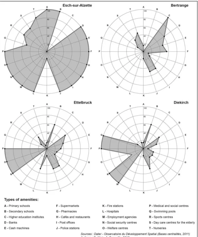
In a first step, it is possible to represent the country’s urban framework in a detailed
amenity through its shape (Figure 1). Each axis is represented by an index which ranges from 0 to 100, where 0 indicates the absence of the considered amenity in the
municipality and 100 is determined by the second municipality in which the number of amenities is the highest2. Such a descriptive model, based on a visual analysis of forms, leads to a comparative reasoning (Reymond, 1968).
Figure 1. Four examples of municipal profiles
2
Figure 1 shows four types of rather different municipalities. First, Esch-sur-Alzette, which is the second largest city in the country, presents the highest values (with the exception of Luxembourg City) for fourteen types of amenities. It should be added that the new location of the University of Luxembourg in Esch-Belval within the
municipality of Esch-sur-Alzette (foreseen in 2015), will further reinforce its centrality. The second municipality represented here, Bertrange (6,400 inhabitants), is close to Luxembourg City and has a substantially less comprehensive profile. This municipality hosts numerous enterprises, businesses and restaurants, but has relatively few public amenities due to the proximity of Luxembourg City. The two others municipalities which are represented are Diekirch (6,500 inhabitants) and Ettelbruck (8,000
inhabitants). They are supposed to constitute a structuring bi-polar metropolis for the northern part of the country according to the national spatial development strategy. A deeper analysis of their profiles shows interesting complementarities. Diekirch hosts an employment agency and a swimming pool whereas Ettelbruck is endowed with a hospital, a welfare centre and a day care centre for the elderly.
Thus, these profiles are useful for visualising the diversity of amenities within municipalities, and especially for identifying the urban hierarchies. However, these descriptive models, based on a visual comparison of forms, are difficult to implement when the number of profiles is too large. This is why it is necessary, in a second step, to gather and compute this information into a unique index which allows to identify the different levels within the urban hierarchy. The creation of a single index leads to a reduction of information in favor of a single classification. In the French literature,
which has largely influenced Luxembourg’s spatial policies, urban hierarchy is often
defined by the type of amenities available within a centre and their degrees of rarity (Haumont, 1968; Rochefort, 2002). Based on this conceptual perspective, we developed a measure of the rarity of a type of amenity within a municipality with the following formula:
Equation 1
with : absence or presence of a type of amenity a in the municipality i
n : number of municipalities
: measure of the rarity of the amenity a in the municipality i
In the case study of Luxembourg, the values range theoretically between 1 (all the amenities are concentrated in one municipality) and 0.0086 (1 divided by 116, expressing that each of the 116 municipality hosts one or several amenities). The
selected amenities can then be calculated for each municipality. This index takes into account the level of rarity of each type of amenity. Its formula reads:
Equation 2
with m : number of types of amenity taken into account
: index of urban centrality of the municipality i standardized by the highest value (basis
100= Luxembourg-city).
The results provide a unique but synthetic map of the urban hierarchy based on the diversity of amenities within the municipalities (Map 1). The resulting map is relatively conventional. It visualises the hierarchy of centres and highlights superior urban centres. In most cases, this representation confirms the view of the national planning policy as well as the fact that the urban centres which present higher degrees of urban centrality
are the “development and attraction centres” identified by the national authorities.
The most populated areas are also, in most cases, those which have the highest
centrality indexes (Luxembourg, Esch-sur-Alzette). This result is obvious considering that amenities which are rare are primarily located at the heart of population centres. The development and attraction centres, which are prioritised by the spatial planning policy in the Grand-Duchy, have a larger diversity of amenities and are also likely to fulfil the expectations of the surrounding municipalities with regards to consumer goods and services at different levels (national, regional, local). However, the municipalities located in the urban periphery around the capital also present relatively high urban centrality values, even equal to those of certain development and attraction centres. This is true for Bertrange or Walferdange. These municipalities host activities that are
closely linked to their proximity to the capital. They are often located in the areas surrounding Luxembourg City because of land availability and more affordable land prices.
In summary, these findings on Luxembourg’s urban framework confirm the dominant
5. Towards an approach of accessibility to amenities
There are few studies which approached urban hierarchy with a measure of the accessibility to a range of different amenities. In this paper, accessibility to amenities can be defined as the ease with which people have access to amenities by using the available modes of transport. A research project financed by ESPON and named INTERCO (ESPON, 2011) was carried out in order to provide indicators, at theEuropean level, for a better evaluation of the quality of access to major public amenities such as hospitals or secondary schools, and the population potentially served by them as well. However, in this study at a different scale, accessibility only refers to one type of amenity at a time. Formerly, results had been obtained within the framework of other ESPON studies on all the member states, relative to accessibility, by calculating the total population or the volume of GDP accessible within a given period of time
(ESPON, 2006), yet without directly addressing the issue of accessibility to amenities. At the scale of a whole country, Vandenbulcke et al. (2009) mapped out the degree of accessibility to cities in Belgium by differentiating situations during peak and off-peak hours. This approach highlighted the highly unequal distribution of accessibility to cities within a country that is nonetheless densely populated. Nevertheless, accessibility to amenities was not integrated in this approach, which focused rather on accessibility to population centres. Still at the country-wide level, other studies have analysed accessibility to public amenities, but often in a piecemeal way, by targeting only one particular amenity (Langford, 2010). These studies were not conceived to provide territorial diagnostic tools allowing the evaluation of accessibility to all amenities within a territory. Furthermore, the study of Apparicio and Seguin (2006) on the accessibility to a range of amenities evaluates accessibility with a metric distance (and not time distance). Lastly, Caubel (2006) studied the accessibility to a range of specific goods and services in Lyon, but without defining a hierarchy of places concerning their
accessibility to urban amenities. The assumption which guided our approach is that each individual needs multiple amenities which vary depending on his age, health, income and mobility.
To analyse the potential accessibility to all amenities, we used a road traffic model that calculates time distances between origins and destinations (Klein et al., 2011). We decided to base our study on the accessibility by car (and not by public transport) knowing that it largely prevails in Luxembourg. Indeed, 76 % of the daily commuter journeys within Luxembourg are done by car (Carpentier & Gerber, 2009), despite all the attempts to promote public transport. Thus, it is clearly this type of accessibility which is favoured by the residents in their choice of location and which contributes to the structuring of spatial development at the expense of the objectives of a more sustainable development and alternative mobility. The outcomes were then combined with the previous indicator of urban centrality. As a consequence, we obtained another picture of centrality which expresses accessibility to urban amenities based on the time-distance needed to reach a range of them. Due to the lack of a reliable National
at 20 minutes, corresponds approximately to the mean duration of a trip in Belgium (Hubert & Toint, 2002) and in France (CGDD, 2010). The second threshold is at 10 minutes, which is the median duration of a trip in Belgium, according to the same authors. We decided to adopt two thresholds because of the great variability of the trips durations, depending on their purpose. For instance, the mean duration of a trip for shopping purposes is 13 minutes in France (Rallet & Torre, 2007). The inclusion of these time thresholds is shown in equation 1. The parameter Sa,i is adjusted as follows:
: absence or presence of a type of amenity a within an access time lower than
t minutes from the municipality i (origin)
t = 10 minutes for map 2a and t = 20 minutes for map 2b
The degree of rarity of the different urban amenities is taken into account, since the less widespread an amenity is in different municipalities, the higher the score of a
municipality located within a time frame of 10 to 20 minutes from another municipality which hosts such an amenity. This point is important to take into consideration since the psychologically tolerated distance needed to reach an amenity grows proportionally with the rarity of this amenity. Of course, this model is not free of criticisms and limits. For instance, it is only based on the presence or absence of an amenity within a
municipality and it does not take into account the overall number of amenities of one type that can be found within a single municipality. Moreover, the differences of quality concerning the amenities of each type, but also their use frequencies have not been taken into account, and such differences can heavily impact the polarizing effect of the different municipalities. Nevertheless, we believe that it contributes to depict the issue of the potential general accessibility to urban amenities.
Significant differences can be observed between the synthetic centrality map (Map 1) and the maps of the accessibility to amenities (map 2). Admittedly, the extremes values in the urban hierarchy do not change. Unsurprisingly, the capital city retains its primary position and the isolated rural villages, such as those in the north of the country, still show the lowest potential accessibilities to amenities3. In contrast, significant
differences appear in Luxembourg City's periphery. In this area, municipalities benefit from good access to all the amenities of the country. Some even have index values that are higher than those of medium-sized urban centres. This means that even if these suburban municipalities have only limited amenities within their territories, they offer, in terms of time distance, a decent access by car to a large diversity of amenities. For instance, according to our model, Kopstal or Reckange-sur-Mess, which are small-sized municipalities, have better car accessibility indexes than municipalities which are more populated and better equipped, such as Ettelbruck, Diekirch, Wiltz or Echternach, since they are located near the capital city. This first insight seems quite logical. But more surprisingly, small municipalities located between different urban centres benefit from the proximity and complementarity of these centres and show values that are much higher than expected in these kinds of locations. This is the case of numerous municipalities (like Erpeldange, Eschweiler, Mondercange or Lorentzweiler) which draw, all together, a hierarchy of urban centrality which is considerably different from the first map. As a consequence, it seems that our model validates our assumption. Indeed, a polycentric urban framework at the scale of a territory like Luxembourg can potentially contribute to disrupting the structuring role of the urban centres and fostering urban sprawl in suburban and rural municipalities.
3
6. Conclusion
In this paper, we compared two different approaches of urban hierarchy related to the offer of amenities: one based on a conventional spatial proximity approach, and the other one based on access time. This first approach provides a good picture of the direct accessibility of people to the amenities located within their municipality of residence. Such a representation, based on a proximity paradigm, can be useful since it highlights the densities of amenities and, therefore, urban centralities. The second approach depicts and compares the accessibility to a wide range of amenities starting from each
municipality of origin. These second maps do not represent the urban hierarchy as such, but they provide a ranking of the municipalities according to the criterion of
accessibility to amenities in 10 or 20 minutes. Whereas the first map is a representation of an urban hierarchy, the second set of maps indirectly highlights the forces which drive spatial development in Luxembourg according to networks and flow paradigms.
The comparison between these two approaches shows differences in the territorial structures and raises questions. Indeed, if the first map gives a clear image of the very well-known urban hierarchy, the second set of maps shows the polarization of space by a network of urban centres and provides a more nuanced picture of the urban hierarchy. Numerous municipalities that are relatively poorly equipped seem to offer,
paradoxically, a good level of accessibility to amenities, due to their proximity to one or several urban centres. This finding challenges the positions held by central planners in Luxembourg, which are based on the hypothesis that a more balanced territorial
structure, favoured by a better provision of amenities in secondary urban centres, would lead to a more sustainable and concentrated dynamic of spatial development within existing urban centres. Using our approach, we have been able to foreground the fact that suburban municipalities can benefit from their intermediate position between different urban centres by offering a good accessibility to amenities by car. As a consequence, fostering a polycentric development in such a spatial context can
potentially increase the attractiveness of these suburban municipalities. Such a process would go diametrically against the objectives of the national spatial planning policy. Of course, both analytical approaches presented here have their advantages and
disadvantages, and none of them can perfectly explain the behaviours of agents who do not always follow a clear rationale when they choose a location. Location choices are based on complex arbitrations which involve land prices, housing preferences, but also the accessibility to amenities. They are often a mix between contradictory objectives: presence of urban amenities versus proximity to nature, urban centrality versus large land plots, good accessibility versus low prices, and so on.
In this paper, we aimed at showing that planning strategies should consider both approaches and rationales in order to grasp, in a more comprehensive way, the complexity of the driving forces that make urban centres play a role in spatial
being supported by binding regulations towards the possibilities for building in
suburban or rural municipalities. Otherwise, a polycentric strategy pursued at the scale of a functional urban area can potentially lead to undesirable effects. Twenty years ago, Peter Hall already highlighted these potentially negative effects: "Polycentric urban regions may, therefore, encourage cross-commuting by car" (Hall, 1993, p. 888). Nevertheless, it is important to emphasise that we have only tested our approach for the case-study of the Grand-Duchy of Luxembourg, with its quite specific settings, such as a small country with only one major city, an important demographic growth and a high car dependency. It has not been proven to be valid in a larger region in which there is no important daily commuting between the centres, due to their distance. It would therefore appear that promoting polycentricity in spatial planning can have very different impacts depending on the spatial scale to which the spatial strategy is applied. As Kloosterman and Musterd argued:"Processes do not automatically have to repeat themselves in the same way at different levels of aggregation" (2001, p. 626).
References
Adams, J. (1999). The social implications of hypermobility. OECD Env. Directorate, Unclassified ENV/EPOC/PPC/T (99) 3/FINAL/REV1.
Apparicio, P. & Séguin, A.M. (2006). Measuring the accessibility of services and facilities for residents of public housing in Montréal. Urban Studies, 43(1), 187-211.
Arndt, M., Gawron, T. & Jähnke, P. (2000). Regional policy through co-operation: from urban forum to urban network. Urban Studies, 37 (11), 1903-1923.
Carpentier, S. & Gerber, P. (2009). Les déplacements domicile-travail : en voiture, en train ou à pied ? [Home to work commuting: by car, by train or by foot?]. Vivre au Luxembourg, 53, 2 p.
Caubel, D. (2006). An increase of public transport and accessibility to urban amenities, some limited results: The case of the Lyons conurbation. WIT Transactions on the Built Environment, 89, 507-516.
Cauvin, C., Escobar, F. & Serradj, A. (2010). Cartography and the Impact of the Quantitative Revolution. ISTE - Wiley & Sons.
CEMAT (1991). Schéma européen du développement du territoire [European pattern of
Spatial Development]. Conseil de l’Europe, Service de l’édition et de la
documentation, Strasbourg.
CGDD (2010). La mobilité des Français. Panorama issu de l'enquête nationale transports et déplacements 2008 [The mobility of the French. Overview of the transport and travel national survey]. Paris: Revue du CGDD, Service de l'observation et des statistiques, Ministère de l'Ecologie, du Développement durable, des Transports et du Logement.
southern Germany: An economic-geographic study of the legality of the spread and development of the settlements with urban functions]. Jena, Gustav Fischer. Davoudi, S. (2003). Polycentricity in European Spatial Planning: From an analytical
tool to a normative agenda. European Planning Studies, 11(8), 979-999 Davoudi, S. (2005). Understanding territorial cohesion, Planning Practice and
Research, 20(4), 433-441.
De Boe, P., Hanquet, T. & Maréchal, L. (2010). Territoires wallons [Walloon territories]. SDER. Retrieved July 18, 2012, from
http://cpdt.wallonie.be/old/Data/publications/territoire%28s%29wallon%28s%2 9/TW5/4AtE.pdf
Decoville, A. & Feltgen, V. (2012). La centralité urbaine au Luxembourg : analyse et perspective. [Urban centrality in Luxembourg: analysis and perspective]. Luxembourg : rapport pour le Ministère du Développement Durable et des Infrastructures.
Decoville, A. & Sohn, C, (2012). Mapping the Structuring of a Cross-border
Metropolis. The Functional Urban Region of Luxembourg, In C. Sohn (eds), Luxembourg, An Emerging Cross-border Metropolitan Region. Brussels: Peter Lang.
Duhr, S., Colomb, C. & Nadin, V. (2010). European spatial planning and territorial cooperation. London: Routledge.
European Commission (1999). ESDP – European Spatial Development Perspective. Towards Balanced and Sustainable Development of the Territory of the European Union. Luxembourg, Official Publications of the European Communities.
ESPON (2011). INTERCO. Indicators of territorial cohesion. Luxembourg: ESPON. ESPON (2006). Spatial Scenarios and Orientations in relation to the ESDP and
Cohesion Policy. Luxembourg: ESPON.
EU Ministers Responsible for Urban and Spatial Development ( 2007). Territorial Agenda of the European Union: Towards a more competitive and sustainable Europe of diverse region. Leipzig, Publications Office of the European Union. EU Ministers Responsible for Urban and Spatial Development ( 2011). Territorial
Agenda of the European Union 2020: Towards an Inclusive, Smart and Sustainable Europe of Diverse Regions? Gödöllő, Publications Office of the European Union.
European Parliament (2010). Charter of Fundamental Rights of the European Union. Official Journal of the European Union, 2010/C83/02, 389-403.
Evers, D. (2008). Reflections on territorial cohesion and european spatial planning. Tijdschrift voor Economische en Sociale Geografie, 99 (3), 303-315.
Faludi, A. (2005). Polycentric territorial cohesion policy. Town Planning Review, 76 (1), 107-118.
Faludi, A. (2007). Territorial cohesion policy and the European model of society. European Planning Studies, 15 (4), 567-583.
Development, 52, from:
http://www.nordregio.se/Global/EJSD/Refereed%20articles/refereed52.pdf
Gualini, E. (2008). Territorial cohesion' as a category of agency: The missing dimension in the EU spatial policy debate. European Journal of Spatial Development, 28, from:
http://www.nordregio.se/Global/EJSD/Refereed%20articles/refereed28.pdf
Hall, P. (1993). Forces shaping urban Europe. Urban Studies, 30, 883–898.
Haugen, K. (2011). The advantage of 'near': Which accessibilities matter to whom? European Journal of Transport and Infrastructure Research, 11 (4), 368-388. Haumont, B. (1968). Hiérarchie et armature urbaine [Urban structure and hierarchy].
Revue française de sociologie, 9(2), 251-256.
Hubert, J.P. & Toint, P. (2002). La mobilité quotidienne des Belges [The daily mobility of the Belgians]. Namur: Presses Universitaires de Namur.
Innenministerium (2004). Ein Integratives Verkehrs -und Landesentwicklungskonzept für Luxemburg, Luxembourg [An Integrative traffic and Spatial development plan for Luxembourg]. Luxembourg.
Kaplan, R. & Austin, M. (2004). Out in the country: sprawl and the quest for nature nearby. Landscape and Urban Planning, vol. 69, pp. 235-243.
Klein, S. & Schmitz, F. (2011). Modeling and simulating Accessibility within the Luxembourg cross-border area. Proceedings of the BIVEC/GIBET Transport Research Day 2011, 365-375.
Kloosterman, R. & Musterd, S. (2001). The polycentric urban region: towards a research agenda. Urban Studies, 38 (4), 623-633.
Langford, M. & Higgs, G. (2010). Accessibility and public service provision: evaluating the impacts of the post office network change programme in the UK.
Transaction of the Institute of British Geographers, 35, 585-601.
Lösch, A. (1940). Die räumliche Ordnung der Wirtschaft [The spatial organization of the economy]. Iéna: Fischer.
Meijers, E. (2008). Measuring polycentricity and its promises. European Planning Studies, 16 (9), 1313-1323.
Meijers, E.J., Waterhout, B. & Zonneveld, W.A.M. (2007). Closing the Gap: Territorial Cohesion through Polycentric Development. European journal of spatial
Development, 24, from: http://www.nordregio.se/EJSD/refereed24.pdf
MIAT (2003). Programme directeur de l’aménagement du territoire [Directing program for spatial planning], Luxembourg, from:
http://www.dat.public.lu/publications/documents/programme_directeur/program me_directeur_2003_fr_complet_br.pdf
Newman, P., & Thornley, A. (1996). Urban Planning in Europe: International Competition, National Systems and Planning Projects. London: Routledge. Rallet, A. & Torre, A. (2007). La proximité à l'épreuve des technologies de
Reymond, H. (1968). L'actualité des modèles graphiques en géographie humaine [The state of the art in graphical models in human geography]. Cahiers de
Géographie de Québec, 26, 177-216.
Rochefort, M. (2002). Les notions de réseau urbain et d’armature urbaine [Notions of
urban network and urban structure], Strates, from http://strates.revues.org/512
Shaw, D. & Sykes, O. (2004). The Concept of Polycentricity in European Spatial Planning: Reflections on its Interpretation and Application in the Practice of Spatial Planning. International Planning Studies, 9 (4), 283-306.
Taylor, P.J. (2000). World cities and territorial states under conditions of contemporary globalization. Political Geography, 19, p. 5–32.
Vandenbulcke, G., Steenberghen, T. & Thomas, I. (2009). Mapping accessibility in Belgium: a tool for land-use and transport planning? Journal of Transport Geography, 17 (1), 39-53.
Vandermotten, C., Halbert, L., Roelandts, M. & Cornut, P. (2008). European Planning and the polycentric consensus: wishful thinking? Regional Studies, 8(42), 1205-1217.
Vanolo, A. (2010). European spatial planning between competitiveness and territorial cohesion: shadows of Neo-liberalism. European Planning Studies, 18(8), 1301-1315.
Waterhout, B. (2008). The institutionalization of European Spatial Planning. Amsterdam: IOS.