CONCEPTUAL FRAMEWORK FOR EDUCATIONAL DISASTER
CENTRE “SAVE THE CHILDREN LIFE”
T. Bandrovaa*, M. Kouteva , L. Pashovab c, D. Savovaa, S. Marinovaa a
UACG, Laboratory on Cartography, Sofia, Bulgaria – [email protected], [email protected], [email protected]
b
UACG, Department of Computer Aided Engineering - [email protected]
c National Institute of Geophysics, Geodesy and Geography, Bulgarian Academy of Sciences, Bulgaria – [email protected]
Commission IV, WG IV/7
KEY WORDS: Natural Disaster, Educational Centre, Children’s Disaster Preparedness
ABSTRACT:
Millions of people are affected by natural and man-made disasters each year, among which women, children, elderly persons, people with disabilities or special needs, prisoners, certain members of ethnic minorities, people with language barriers, and the impoverished are the most vulnerable population groups in case of emergencies. Many national and international organizations are involved in Early Warning and Crisis Management training, particularly focused on the special target to safe children and improve their knowledge about disasters. The success of these efforts is based on providing the specific information about disaster preparedness and emergency in adapted for children educational materials, accompanied with simple illustrative explanations for easy and fast understanding of the disasters. The active participation of the children in the educational activities through appropriate presenting the information, short training seminars and entertaining games will increase their resilience and will contribute significantly to their preparedness and adequate response in emergency situations. This paper aims to present the conceptual framework of a project for establishing an Educational Disaster Centre (EDC) “Save the children life” at University of Architecture, Civil Engineering and Geodesy (UACEG), providing relevant justification of the necessity to organize such centre in Bulgaria and discussing good practices in Europe and worldwide for children' education and training in case of disastrous event. General concepts for educational materials and children training are shared. Appropriate equipment for the EDC is shortly described.
* Corresponding author
1. INTRODUCTION
Building resilience to disaster risk, climate change and conflict was recognized as a significant gap in the United Nations running initiative Millennium Development Goals. It has already been identified as a key area for new discussions (UN, 2015; www.un.org/millenniumgoals/). After the adoption of the Hyogo Framework for Action in 2005 as an important instrument for raising public and institutional awareness, a progress in reducing disaster risk at local, national, regional and global levels in different countries has been achieved, but millions of people are still affected by natural and man-made disasters each year. Natural hazards are inevitable natural phenomena and the vulnerability, in general, describes the relationship, which people have with the environment, social forces and institutions, and cultural values. One of the main tasks of the specialists involved in Early Warning and Crisis Management (EW & CM) is to contribute to reducing the vulnerability of population and to extent the people’s capacity to resist hazards, to cope with the challenges associated with various disasters and relevant emergency situations, as well as to recover from them.
Recently, at the Third World Conference on Disaster Risk Reduction (DRR), held in Sendai, Japan, the post-2015 framework for DRR has been adopted to be active till 2030 (A/CONF.224/CRP.1, 2015). In order to be efficient and
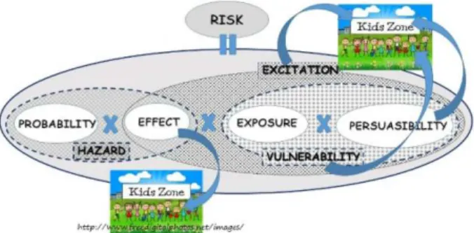
school or playing outside, children are exposed to different risks associated with natural disasters (e.g., buildings’ resistance to earthquakes, fires, floods). The children education is particularly relevant to the hazards effects and vulnerability mitigation, since they are explicitly influenced by the different elements of the risk estimates, as it is shown in Figure 1.
Figure 1. Kids zone in natural risk mitigation.
In this article an idea for establishing an Educational Disaster Centre (EDC) “Save the Children Life” at the UACEG in Sofia, Bulgaria is described. This Centre will provide an opportunity for children to acquire a basic knowledge of the natural and man-made hazards. It will enable to enhance the children’ resilience and the ability for response in emergency situation taking advantage of educational materials and tools adapted to their age and needs. EDC might involve Bulgarian, foreign and visiting UACEG students in the educational activities. The target groups of this Educational Centre are children from primary and secondary school, and also their parents and teachers. The necessity of establishing this EDC is related to the various natural hazards, manifested at the Bulgarian territory and to the increasing frequency and intensity of disaster events, many of which are exacerbated by the climate change. The brief data review and disaster statistics, given in this paper, the available geo-data and published information, as well as already developed materials will be used for design and preparation of special educational tools in the EDC “Save the Children Life”. Also, the contemporary scientific achievements, in particular the studies of natural and man-made disasters, their spatial distribution and extent, accessible educational materials, digital visualization technologies, advanced communications tools will be utilize in the training process by experienced University educators and outstanding students. Major benefit of such educational disaster centre will be well informed, educated and responsible rising generation, capable to think spatially.
2. RELEVANT DISASTERS INFORMATION
Educating children means to make them aware about the disaster occurrence on regional and global scale, using appropriate tools. To fulfil such purpose it is good to provide some general information on disaster types and disaster spreadsheet for Bulgaria, Europe, and worldwide and to teach children to work with different, particularly adapted, maps. Disasters happen in all countries of the world: sometimes similar each other, other times they reflect the specificities of the covered regions. Various disasters have different origin and duration, different coverage and areas of impact. Therefore, there is a variety of disaster classifications depending on the parameters that are considered important. The most widely recognized classifications distinguish different disaster types according to: origin; territorial coverage; type of occurrence; duration. For example, natural disasters can be classified
according to their origin in the following subgroups: geophysical, meteorological, hydrological, climatological, etc. (EM-DAT, 2015). Man-made disasters can be classified according to their origin as nuclear and radiation accidents; industrial accidents, crashes, terrorist acts, humanitarian crises, fires, induced seismic events, etc. (Marinova, 2014).
2.1. Worldwide Spreadsheet Data
In 2014, according to the most comprehensive natural catastrophe loss database in the world NatCatSERVICE (http://www.munichre.com/), the number of the registered 980 natural events is much higher than the average one of the last 10 years. The overall losses from these natural disasters were US$ 110bn. In comparison, in 2013 the NatCatSERVICE registered 890 loss natural events worldwide with overall losses of US$ 135bn. 41% of all 980 loss events for 2014 fell into the category of meteorological natural disasters (42% - hydrological, 9% - climatological and 8% - geophysical). The percentage distribution of the main disasters within the geophysical, meteorological, hydrological and climatological fields is roughly in line with the average of the past 30 years. Two devastating natural disasters accounted for 56% of the total 20 500 fatalities across the world for 2013 are heavy monsoon rain in India in June (5 500 fatalities) and Typhoon Haiyan in Philippines, China and Vietnam in November (6 200 fatalities). The three disasters with most fatalities worldwide for the period 1980 – 2014 are: the earthquake in Haiti in 2010 with 222 570 fatalities; the earthquake and tsunami in Sri Lanka and Indonesia in 2004 with 222 000 fatalities; the cyclone Nargis and storm surge in Myanmar in 2008 with 140 000 fatalities.
2.2. Spreadsheet Data for Europe
By 2014, NatCatSERVICE recorded 10% of the all 980 disastrous events, which affected the European territory. Among the all natural disasters in Europe according to EM-DAT (2015) statistics, the earthquakes in Greece affected most people and caused major damages. Going back in the years, it worth to mention the devastating Vrancea earthquakes in Romania in 1940, 1977 and 1986, which affected large European territory (Panza et al., 2010). The Skopje earthquake in 1963 was another regional disaster. Other widely manifested disasters in Europe are the floods and storms. A lot of floods occurred in 2013; therefore it was called “The year of floods”. After the flooding of 1954 and 2002, the 2013 flood in Central Europe was the third most serious event in the last 60 years affecting the catchments areas of the Danube and Elbe.
2.3. Spreadsheet Data for Bulgaria
Figure 2. Percentage distribution of different natural disaster that occurred in Bulgaria for the period 2003-2013.
Disasters caused damages to public and residential buildings, road infrastructure, crops, forest fund and others. According to the administrative division of the country for the period 2003-2008 the average numbers of affected municipalities per year were: 77 – by landslides, 146 – by floods, 8 – by earthquakes, 33 – by snowstorms, 52 – by windstorms, 5 – by drought, 16 – by hailstorms, 7 – by freeze, 24 – other natural disaster, 65 – by accidents, 31 – by pollutions, 12 – by epidemics, 17 – by other disasters (NSI, 2015). There is no particular information provided about disasters, from which each municipality has suffered. In general, most affected are the municipalities of Smolyan, Sofia, Vratsa, Plovdiv, Burgas, Kardzhali, Gabrovo, Montana. The relevant data shown in Figure 3 are based on the time span 2003 to 2008, officially available by NSI
.
0 50 100 150 200 250
La nds
lide Floo
d Earthquak e
Snow storm
W inds
tormDrought Hails
torm Freeze Other
Type of natural disaster
N
um
ber
of
af
fec
ted m
uni
ci
pal
iti
es 2003
2004
2005
2006
2007
2008
Figure 3. Number of municipalities affected by various disasters per year for the period 2003 -2008
The six most significant natural disasters in Bulgaria, from 1900 till now according to the number of deaths are: the earthquake of April 14, 1928 with 107 casualties; the extreme low temperature in January 2012 with 30 casualties; the earthquake on March 4, 1977 (Vrancea, Romania) with 20 casualties; the extreme low temperature in January 2006 with 18 casualties; the floods on 2 July 2005 with 17 casualties and 19 June 2014 with 15 casualties (EM-DAT, 2015). Out of this formal statistics it worth to mention the Kresna earthquake of April 4, 1904 (M ~ 7.2) - one of the strongest events, occurred in Europe so far. Due to this quake, hundreds of houses are significantly damaged and remain uninhabitable. The available earthquake record indicates about 50 victims caused by the foreshock, M ~ 6.9, that stroke 20 minutes before the main shock. Thus, most of the people were already outside of the buildings, when the main shock occurred (Ambraseys, 2001).
3. GOOD PRACTICES AND EXAMPLES FOR CHILDREN EDUCATION IN EW & CM
Many countries that suffer strongly from devastating natural disasters take consistent and extensive measures for education aimed at disaster preparedness with particular care to the ricing generation. International institutions are also largely involved in this kind of activities. It is essential that children are empowered with knowledge and skills about what they can do to prevent disasters and to minimize the consequences of natural hazard. To protect children from environment-related risks now and in the future, UN Office for DRR provided a prevention web-based net (www.preventionweb.net) and UNICEF launched a resource manual to assist governments and education practitioners in scaling up and mainstreaming climate change adaptation and DRR in the education sector (UNICEF, 2012).
In the developed advanced countries (e.g. USA, Australia, Japan) the web-based activities, School Kits & Classroom Activities, Audio Visual Resources are widely used. The Linn County Emergency Management Agency (www.linncounty-ema.org) has organized particular internet site Emergency Preparedness for Kids, where different free downloadable books for children and similar internet links are provided. Some countries such as USA and Japan are aware of the importance of risk reduction education and they have simulation centres that host demonstrations for response in case of different types of disasters. At the internet site of the US Federal Emergency Management Agency FEMA http://www.ready.gov/kids it is clearly stated that disasters affect everyone, so everyone - youth, parents, and community members - need to help prepare. Different materials related to: (i) make a plan, (ii) build a kit, (iii) know the facts and (iv) get involved, are provided for kids, parents and educators. Kids are attracted by the interactive computer graphics and computer games inviting them to “step into the heart of the action as they help the Heroes face everything from home fires to earthquakes”. The “Build a Kit” game brings the kids to a mission for whom it is necessary to find what you need for an emergency kit and to build a checklist along the way. Kids get aware about the Wireless Emergency Alerts - emergency messages sent to cell phones by authorized government agencies to let you know about dangerous weather conditions, emergencies, and other local hazards. Kids get involved in reading alerts, taking action and following the directions. The web site provided by the US Geological Survey’s Earthquake Hazards Program as part of the effort to reduce earthquake hazard in the United States has special learn space addressed to kids. Hazards preparedness information aimed at kids, parents, and educators, online earthquake quiz and other relevant information, activities, games, and puzzles and interactively colour earthquake-related pictures are provided to the public aiming to contribute for improved earthquake preparedness. Music and audio playbacks of the earth shaking are used to find new ways to learn about the earth, earthquakes, musical instruments and music. Tsunami Information for Kids includes brochures, colouring books, and educational links for kids. Institute for Educational Studies and Development of Indonesia developed simulation games that deall with disaster understanding and prevention (http://preventionweb.net/go/5341).
Risk Education Network and the Children and Youth in Disasters Network are also involved. Risk RED's purpose is to increase the effectiveness and impact of DRR education. Risk RED collaborates to determine, develop and promote good practices in translation, localization of content, and design of a wide range of print and digital media, products, and cultural arts vehicles for risk communications. Posters, booklets, brochures, books, emergency “Go” Bags, site-based Exhibit are widely used form of education in Algeria in the framework of the Risk RED project. In Iran, RiskRED deals with earthquake preparedness planning in schools, school textbooks, educational materials and tools. Excellent examples that can be followed are the billboards for building safety, school children’s exhibitions on “Earthquakes and Safety”, educational posters for earthquake drills, earthquake education in kindergartens in Iran. Different national projects, educational materials, distance learning program, structural awareness & non-structural mitigation materials are elaborated in Turkey. Non-structural mitigation including trainers display kit, youth leadership exhibit, and site-based outreach: models, exhibits & fairs, and hands-on tools: toys & models are also widely used in Turkey. In India, Costa Rica, Chilly, different educational materials are combined with different thematic games and physical models demonstrations. Mobile Shake Table is used to simulate earthquakes for educational purposes in Tajikistan, Nepal, India, Afghanistan, etc. Other effort towards education of children in disaster preparedness is performed by the 13th National Children Forum “Smiling Child”, which was organized from 20-23rd of April, 2014, under the theme of “Child Participation in DRR” in Mongolia (http://www.wvi. org/Mongolia/article/children-are-better-prepared-against). More than 140 children from urban and rural provinces have attended the conference to voice their opinions on DRR. Japan is considered to be among the leaders in disaster preparation. Web-based activities and particular evacuation practicing are widely for children education, http://web-japan.org/kidsweb/ cool/ 10-07/002.html.
4. BULGARIAN EXPERIENCE IN PREPAREDNESS AND RESPONSE IN EMERGENCIES
4.1 Responsible Institutions
Educating children is major priority of every society, including all the responsible institutions. Children should be also aware about the role and the principal hierarchy of these institutions. Activities related to the protection of the population in case of threat or occurrences of disasters are carried out by a various governmental and nongovernmental institutions, departments, offices and other operational structures, such as:
1. Ministries and departments; 2. Bulgarian Red cross;
3. District and Municipal administrations; 4. Companies and sole traders;
5. Centres for emergency medical treatment and other health facilities;
6. Non-profit organisations; 7. Armed forces,
8. Volunteers, etc.
These units, offices and other operational structures are components of the Integrated Rescue System (IRS), while the institutional or organisational affiliation and their designated functions or objects are preserved. About 1,550 people are full-time employed at the DG Fire Safety and Civil Protection - the Ministry of Interior (MoI). Civil protection expenditures are
approximately 0.27% of the GDP (EC, 2015). In case of emergencies, the activities related to the protection of the population in Bulgaria can be supported by several international organisations and countries, based on specially signed agreements.
Bulgarian legislation related to ensuring the protection of life and health, the environment and property in case of disaster is permanently updated in accordance with international and EU requirements and standards in this field. The roles of main actorsare regulated by a number of normative documents: Law on Disaster Protection, Law on the MoI, National Plan for Disaster Protection and National Action Plan, National Program for Protection in Disasters, Regulation on terms and conditions for the functioning of the National System for early warning and alert, Strategy to reduce the risk of disaster, etc. The systems for EW & CM have just started to be developed and the MoI is the responsible organization.Since September 30, 2008, the emergency telephone 112 has 100% national coverage and is accessible from anywhere in the country. According to the Act on Amendments and Supplements to the MoI Act, which has been in force since 24 November 2009, the Civil Protection Directorate-General (DG Fire Safety and Civil Protection) became part of the MoI of Bulgaria. The DG Fire Safety and Civil Protection is a national specialised structure of the MoI responsible for performing tasks related to prevention and preparedness, management, reaction and recovery in case of natural and man-made disasters. At central administration level, the DG Fire Safety and Civil Protection – MoI is divided into three main departments: The Operational Activities Department, The Prevention Activities Department, The Administrative Activities Department, The International Projects Sector (EC, 2015). The Situation Centre of the DG Fire Safety and Civil Protection at the MoI conducts the overall coordination in case of disasters. There are also Operational Communication and Information Centres in all 28 districts (regions) of the country. Bulgarian Red Cross has developed and implements a Policy and a Strategy for actions in case of disasters until 2020.
The actions of the people, affected by the Pernik earthquake in May 2012, the floods in Varna and Dobrich in June 2014, and other disasters that occurred in Bulgaria in the recent years, have shown that many people have not training in disaster response. Recent Bulgarian experience of evacuation of adults due to the floods in NE Bulgaria in June 2014 has shown the lack of education in manual signalling for showing the helicopter the emergency landing site (pers. communications, Bandrova, Pashova, 2014). Despite of the strong national policy, technical and institutional capacities and mechanisms for disaster risk management and DRR perspective, the achievements of institutional commitment are not comprehensive and substantial (Boycheva, 2013). National programmes or policies to make schools and health facilities safe in emergencies are missing; contingency plans, procedures and resources in place to deal with a major disaster are not developed according to gender sensitivities and for continued basic service delivery; businesses is not a proactive partner in planning and delivery of response; agreed method and procedure for assessing the damage, loss and needs in case of disasters are lacking; etc.
management and disaster response; providing assistance for the effective use of joint experience and capabilities of the NATO Partners and the international organizations in the field of crisis management and disaster response; providing education and training of military personnel, government officials and civilians, and organizational structures in the field of crisis management and disaster response. Our EDC will definitely look for possibilities for collaboration with this new Unit.
4.2 Programmes for Education in Disaster Risk Mitigation in Bulgaria
In the period 2005 to 2009, the time of Ministry of Disaster Management Policy, some educational materials like text books for teachers, posters and web-page for children were prepared and distributed to Bulgarian schools. Time was not enough to be deployed more widely these activities and to make better use of the developed materials. Occasionally, some exhibitions with children drawing “The disaster through my eyes” are organized at schools or in parallel with some scientific forum, e.g. May, 2003, BAS.
The National Training Centre of the Bulgarian Red Cross has a range of practical training in First Aid and also an earthquake simulator – a 12-ton platform with two rooms where reactions of students in case of an earthquake are tested (Bulgarian Red Cross, 2015). Common behaviour and particular reactions of young people in the earthquake simulator are captured by video cameras and then discussed with instructors of the Bulgarian Red Cross. The aim of such simulations is to help children to learn how to protect themselves and their relatives. Adequate response to strong earthquakes is the best guarantee for their own safety. This centre holds various simulations related to disaster response. In 2011, simulations with the participation of Bulgarian, Greek and French teams were conducted under the project "Modern approaches to prevention among children and students in Europe", which aims to create a sustainable network of organizations from countries in the EU.
The Bulgarian experience with children's education in case of emergencies so far is mainly limited in published posters and brochures, annual evacuation training at kinder gardens and schools and very few demonstrations of the different natural phenomena. There are several experimental works with children on the topic (Bandrova and Nikolova, 2005; Bandrova and Milanova, 2011). Providing our students knowledge on preparedness for crises situations will help them to adapt and even master the use of the new information technologies, such as digital maps, GIS, GPS as major tools for reinforcing the disaster response capacity. The need to include specialized education and training of pupils and students is pertinently considered into different activities planned by the EU internally for the European members states and externally for developing countries (Bandrova et al., 2009).
According to the Bulgarian progress report on the implementation of the Hyogo Framework for Action for the period 2011-2013, a substantial achievement has been attained applying the effective modern methods for education on the disaster preparedness and protection (Boycheva, 2013). Responsible EW & CM institutions perform regular information campaigns for awareness of the population about the main rules for reaction and protection in case of disasters, and many initiatives are undertaken till now. They organized “Open Doors Days” and different events devoted to the International Disaster Risk Reduction Day to promote the DRR efforts in the
country. Due to different limitations - financial resources and/ or operational capacities - professional DRR education programmes are still not elaborated. Currently, the following major activities have been traced by the Government in the Disaster risk reduction strategy (2014-2020) (Priority III): (i) development and use of scientific research achievements and innovations; (ii) building a culture of disaster protection through the use of advanced education tools and (iii) raising the awareness and promotion of the participation of the population in DRR activities (Bulgaria – government, 2014).
5. CONCEPTUAL FRAMEWORK OF THE EDUCATION DISASTER CENTRE (EDC)
Child reactions before, during and after emergencies are different comparing to those of adults due to physiologic, anatomic, immunologic and behavioural differences. Educational process, focused to understanding and psychological response of children, considering their age-dependent is foreseen in the EDC. Appropriate educational measures are planned with proper care so that children are not unduly alarmed and stressed, and in the same time a useful operational information using contemporary illustrations, demonstration approaches, and technology tools to be provided.
Available and newly elaborated child-friendly methods and materials, properly structured according to particular age groups, are under adoption for use in the Centre. The planned education in the EDC involves simulation of different disastrous situations that could hurt people or cause damages. Children’s participation in discussions and demonstration how to behave during such situations is crucial for the successful educational process. It is important to do so the children of different age groups to know the hazard warning symbols and alert signals; how and when to call the emergency number for help; to call the family contact if separated; to keep personal identification information in their possession at all times.
and will be open for all children in Bulgaria from primary and secondary school.
UACEG in Sofia, Bulgaria is a very good place for establishment of the EDC “Save the Children Life”. The University is located in the central part of the capital. Many schools are situated around the University. Students and children from primary and secondary schools are in almost one and the same distance from the University, there are very close metro, tram and buss stations which could be used for pupils coming outside of Sofia. Another good advantage of the proposed place of the EDC is the fact that the biggest park of Sofia is situated very close to the University buildings. The park can be used for practical training of evacuation and special games connected to different disaster situations. Professional educators from different national and international organisations, experienced in the field of emergencies, will be invited to take part in overall training and educational process. Educators from UACEG, BAS and other institutions are enlisted to be involved in the education will be responsible to support the running activities of the Centre. These experts are ready to take care about the regular update of the educational materials and tools. Main actors are educators and PhD students from Laboratory on cartography, Department of Computer-Aided Engineering, and National Institute for Geophysics, Geodesy and Geography - BAS. Invited lecturers from the Ministries of Defence and Interior and all national institutions involved in the DRR policy, as well as lectures from EU Universities and research institutions have the necessary expertise and readiness to take part in the educational process. The latter might be invited in the framework of different international collaboration programs – e.g. COST, ERASMUS+ and other Grant possibilities. The established good professional contacts with colleagues from abroad, personally involved in EW & CM activities will be of significant help in the effective use of the different international and EU programs and competitions for funding this initiative.
5.1.
Developing Spatial Thinking
Major milestone in improving the children's knowledge about natural and man-made disasters is developing their cognition competencies and skills to deal with geo-spatial information. It is expected that child have a "basic" understanding of the terms Geography and Information from the primary and secondary school. The contemporary tools and technologies providing geo-spatial information can be easily used. The major challenge of their use concerns the understanding fundamental spatial concepts, which are statistical, and so forth. In any domain of knowledge, multiple forms of thinking are used: for example, the science uses linguistic, hypothetical, mathematical, logical, and many other thinking processes. The concept of space defines spatial thinking as a distinctive form of thinking. Although spatial thinking is a universal has been acquired informally in the early childhood (Goodchild and Janelle, 2010). There are many forms of thinking: verbal, logical, metaphorical, hypothetical, mathematical, mode of thinking, it has distinctly different manifestations in different disciplines. Hidden behind many of the daily operations of everyday life, the workplace, and science, spatial thinking is integral to successful problem solving (CSTS, 2015) - mathematics, natural science and geography.
The current school curricula are designed to meet content standards for specific disciplines, originating at the national level, that express what students should know and be able to do at various stages throughout their school careers. They do not
contain systematic and comprehensive attempt to teach students to think spatially as part of the national science and mathematics standards (CSTS, 2015). It is very important to make children aware that the spatial thinking is a crucial and integral to everyday life. The education and training at EDC “Save the Children Life” is going to help children to develop their spatial thinking. It could help them to realize that people, natural objects, human-made objects, and human-made structures exist somewhere in space, as well as people and things interact in terms of location, distance, direction, shape, and pattern.
The key to spatial thinking is a constructive amalgam of three elements: concepts of space, tools of representation, and processes of reasoning (CSTS, 2015). Making familiar pupils with the meanings of space, we can use its properties (e.g., dimensionality, continuity, proximity, separation) as a vehicle for formulation of problems, finding answers, and expressing and communicating solutions. The meaning of space entails different ways of calculating the distances (system units), the basis of coordinate systems (e.g., Cartesian versus polar coordinates), and the nature of spaces (e.g., in terms of the number of dimensions 2D and 3D). Representation is associated with the relationships among views (e.g., plans versus elevations of buildings, orthogonal versus perspective maps), the effect of projections (e.g., Mercator versus equal-area map projections), and the principles of graphic design (e.g., the roles of legibility, visual contrast, and figure-ground organization in the readability of graphs and maps). Children groups of different age could interact with the map by locating themselves and known landmarks on it. That will allow them to learn how to orient themselves on a map and gain invaluable spatial knowledge. Practical idea about relationship among views might be provided, making pupils read different plans of evacuation in case of emergency situation; principles of graphic design might be lightly introduced performing games with the children, during which they compose a map of a small area, marking some important key-objects. The idea of reasoning might be explained illustrating different ways of thinking about shortest distances, the ability to extrapolate and interpolate (e.g., projecting a functional relationship on a graph into the future, estimating the slope of a hillside from a map of contour lines), and taking decisions (e.g., given traffic reports on a radio, selecting a detour). The proposed Centre is an appropriate place to explain and illustrate different relationships within spatial structures using maps and/or multidimensional scaling models. Thus dynamic properties of objects and the relationships between objects might be easily perceived, remembered and analysed by the elementary school students. For this purpose, variety of models and media like graphical text, images, and video and virtual reality are planned to be used. The power of GIS might be explained to the elementary school pupils illustrating the answers of the five generic questions and relevant tasks’ types as:
• Inventory and/or monitoring: (i) What is it…?; (ii) Where is …?; (iii) What has changed since …?;
• Spatial analysis: (iv) What spatial pattern exists …?
• Modelling: (v) What if …? (modelling) (CSTS, 2015 and ref. in).
5.2 Educational Materials and Tools
general-purpose, high-tech applications that support spatial thinking (e.g., Excel, PowerPoint); and (3) to develop the skills that will allow them to learn new low- but especially new high-tech applications.
It is not easy to teach or/and train these skills separately from particular examples. “Step-by-step” education of elementary school pupils seems reasonable effort towards fostering the spatial literacy, which, in general, can be achieved only by systemic educational reform. To develop spatial thinking in elementary school pupils, different possibilities of making use of maps puzzles are prevised. Different physical and thematic maps with large scales, that has to be assembling for preliminary set short time (5 - 10 minutes) will be used as puzzle background. Digital computer questionnaires will be developed and used to provoke the children’s spatial thinking for reading different maps and warning symbols.
Various interesting and useful brochures, posters, educational materials in paper version are currently available in the book market. Additional updated information will be regularly provided in the EDC – new printed materials, as well as information available via web and social networks. Students work is an important contribution to the EDC activities, enriching the possibilities to present the variety of topics connected to disaster and EW & CM. A very good and winning idea is to involve young students as lecturers at EDC - this age group is well accepted by the children and can easily involve them in various games specially prepared for the target age groups. Other possibility to make children more familiar with the general common issue of the disaster preparedness is to organize exhibitions of children’s pictures related to disaster topics and cartography. Established effective forms of education are also foreseen in the EDC training process: e.g. brief lecture or short video material, followed by short discussion with questions and encouraging awards for the children, and team work for mapping some disaster-topics of the presentation on properly adapted maps. The proposers of the Department of Geodesy at UACG and the Bulgarian Cartographic Association have rather encouraging experience with such competitions and exhibitions of maps drawn by children.
The disaster preparedness as well as rapid and adequate disaster response includes knowledge on proper use of thematic maps or other graphic materials, reading special symbols in these materials. This knowledge couples the ability to read and to construct such symbols. Usual requirement to these symbols is to make them associative for the users even without the use of a legend, especially in cases of emergency situations (Konecny & Bandrova, 2006). Many organizations have design particular symbol systems for the needs of their activities. A map symbol system for disaster management in Bulgaria has been proposed by Marinova (2014). This system includes four level hierarchical classifications of objects and phenomena according to their type and origin. The symbols are grouped in the following categories: disasters; infrastructure; protection services and infrastructure for protection; affected people and affected infrastructure; operational sites and activities are shown with different colours and shapes so that they are identifiable, simple, and associative. The classification of objects and phenomena and the cartographic design of the symbols, included in the new symbols’ system, aim to improve the entire process of crisis management and to facilitate the actions of people, affected by disasters. Additional psychological analysis is needed to understand children's thinking and after that this symbol system should be adapted to
children. The adapted symbols might be used in DRR brochures, posters, and educational materials and tools.
Raised in the very high technological twenty-first-century, today's children have very intuitive skills to cope with challenges of advanced technologies and computer sciences. This is the reason more and more educational practices of disaster management to be oriented to GIS, 2D and 3D simulations and visualizations and real-time applications, improving the processes of perception of the disaster scenarios. The internet access almost everywhere gives the children large opportunities for doing on-line hazard maps, emergency rapid mapping and video simulations, based on geo-information and satellite images. "Map your school" - a project of UNOSAT, UNICEF and the Government of Panama is great example of good practice for on-line interactive platform for children which allows them to map by themselves the hazardous places around their school that might be adopted in our future Centre. This way the project does not only introduce the importance of emergency preparedness to the kids, but the acquired data is also used in real cases of evacuation and rescue operations (UNITAR, 2013).
Simulations are inseparable part of the modern training in disaster cases. Both types of simulations, 2D and 3D, provide very good base for spatial thinking in introducing emergency scenarios. The interactive web-based hydrological simulation system proposed by Demir (2014) for educational purposes gives the opportunity to students to perform various parametric analyses playing with the parameters, describing the environment and to make use of relevant historical and actual data. Simulation training systems such as Advanced Disaster Management Simulation (ADMS, 2015) provide advanced tool for simulation of large scale incidents - natural or man-made, including floods, earthquakes, landslides, terrorist attacks, structural collapse, industrial accidents, nuclear strikes, wild fires, civil disorder, hazardous material and biological releases, hurricanes, etc. The simulations might include occurrence and/or escalation of a variety of such events. Such kinds of simulation systems are used for preparation, response, recovery, and risk mitigation trainings. They let users to develop their own scenarios according to the specific training and practical needs. Large set of available examples is at disposal to be used in the proposed EDC to train children by simulation videos based on the simulation training system showing and explaining preparation and response in case of different types of disasters.
5.3 Simulation equipment
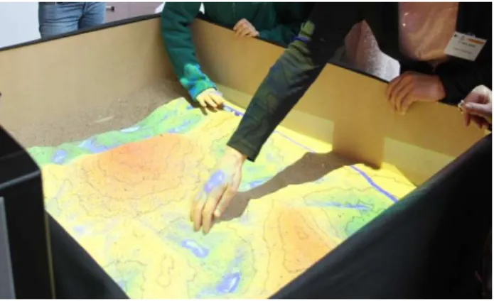
and ECHO Lake Aquarium and Science Centre (Kreylos, 2012) is an appropriate option for the EDC “Save the Children Life”. Through this real-time integrated augmented reality system, topographical models by shaping real "kinetic" sand can be physically created (see Figure 4). It is compound only from a Kinetic 3D camera, a projector, a computer, a sandbox and free simulation and visualization software (Reed et al., 2014). This equipment will be unique for Bulgaria. Because of its accessibility, the system has been used from many institutions worldwide for demonstrating concepts of geology, hydrology, topographic map reading, etc. The construction of an AR Sandbox as a part of the EDC equipment will contribute to the introduction of the flood disaster nature to children by means of sand surface and flow simulation. This demonstration visually supports and eases the process of explaining terms as relief, water spreading, river flow, and flooded area.
Figure 4. Water flow simulation by Simulation Augmented Reality Sandbox (Courtesy of B. D. Vliegher
Dr. C. Stal,
Ph.de Mayer, Gent University, Belgium).
To fully focus children's interest in the simulations, they are involved in creating the situation in the sandbox - building a terrain and placing their own handmade house models over it. The AR Sandbox is a suitable tool that helps children to understand the need to follow the learned basic lifesaving actions via interactive visual representation and real-time simulation.
Earthquakes are another frequent and devastating disaster in Bulgaria. The proposed Centre is going to provide trainings for children in order to improve their response in a case of earthquake occurrence. Simulation model will give answers to questions important for the children, like how is manifested such disastrous event; what harms it can cause and what are the possible consequences; what to do during and after an earthquake. Earthquake simulations with simulation table or the shake table are widely used experimental techniques to test the response of structures to verify their seismic performance, but they are not particularly targeted to children audience
.
The use of earthquake simulation table or the shake table for education and training purposes is important element in the proposed project. Small shaking table is other important interesting part of the EDC equipment that provides the opportunity to have a bird's eye view of shaking city model, placed on the device. These simulations are capable to visualize and enrich the children's notion and knowledge of the devastating earthquake power. The older children will have the opportunity to construct their own building with materials at hand and to test them on the simulator, learning more about building constructions. The available testing labs at UACEG will be open for demonstration for EDC visitors.Although the fires do not affect so large areas and people, as floods and earthquakes, their frequency is high enough to be considered as equally hazardous. In many cases children have fallen victims to fires, mostly started in their homes and schools. Improving children's evacuation and organizational skills in this case of emergency situation is an important task for the “Save the Children Life” Centre. EDC and the closely located park are very suitable training sites (Bandrova and Milanova, 2011). Fire emergency training will be focused on evacuation trainings and simulation games, developed depending on the participants’ age. To make it more interesting and entertaining, the Centre will be equipped with requisite, which will deepen the sensation of fire emergency. The requisite can be fake fire ignition, system of red flag ropes, etc. Children will have to leave the room or evacuate from the "burning" building for a certain time, following instructions.
5.4 Forthcoming Activities
A set of different activities is planned before and after opening the EDC “Save the Children Life”. The first one is to organize the initial funding of the Centre establishment and to equip it by the necessary techniques, hardware, software, literatures, etc. Running and future national and international projects support this idea; it seems to be the most right way to go on. The next one is to find and enlist volunteers to work for the EDC promotion. Important possibility to be used is to provoke students interested in EW & CM and DRR topics. Their capacity and force will be directed: (i) to elaborate specialized educational materials for pupils and students; (ii) to present the topics to younger auditory. Most financial resources will be necessary to equip the Centre with attractive advanced technologies for simulation of different kinds of events causing disasters. In this direction some ideas have been already started to be realised, like “water simulation with the AR Sandbox”. Major challenges will be the advertisement and the promotion of EDC and communication with the relevant institutions, state and private. Our aim is to provide access to the EDC for as many children from primary and secondary schools to make them prepared when the disaster strike, and to teach them how to save not only their own but also parents and others people’s life.
open access, distributed by Global Spatial Data Infrastructure Association (Rajabifard, 2013).
6. CONCLUSIONS AND FUTURE WORK
Children are a part of the most vulnerable to disaster social groups; therefore they need to be educated continuously in the field of DRR. Important challenge of the advanced researchers and experts is to ensure that knowledge and skills, gained by the children in the DRR training centres during primary and secondary school will be useful throughout their lives. To answer these needs, a conceptual framework for Educational Disaster Centre “Save the children life” establishment at UACEG, Bulgaria, is stated, considering that children are very capable to adopt innovations quickly, to develop their own innovative solutions to real challenges, and to take advantage of complex concepts to reduce risk in disaster situations. Spatial thinking should be taught at all levels in the education system. With advances in the tools and technologies of computation, developing spatial thinking is more readily possible today, but concomitantly, improved cognitive abilities are necessary, to take advantage of rapidly changing support systems. Spatially literate students should be lifelong learners using advantages of the modern tools and technologies.
The main objectives of this Centre are to provide guidance, educational materials and tools to children and their families to be prepared for adequate behaviour before, during and after a disaster using of spatial thinking. The EDC educators will be University teachers, scientists from Bulgarian academy of science, PhD students, and invited foreign professionals. Students’ theses on DRR and EW & CM topics will be used for elaboration educational materials and web-version tools. The first efforts towards EDC establishment will be performed in the framework of two scientific research projects, already financed by the UACEG and Ministry of education and science of Bulgaria. This support will help us to start with preparing of detailed plan of the Centre and to purchase preliminary equipment and software. The pilot experimental work will trace the appropriate directions of our further activities of establishment and development of the Centre. It will point out some potential shortcomings too. UACEG students will be involved in the educational and training EDC activities. The first efforts of the proposed Centre will be towards education of schoolchildren. It is worth to be mentioned, that the undergraduate students need also of relevant education in disaster preparedness and DRR, which will be among the future EDC activities.
The Centre activities could contribute to the policy of the institutional responsiveness to the DRR educational needs and to fill critical gaps in children’s disaster preparedness. The success of the proposed Centre in increasing children resilience strongly depends on the coordinated efforts of the institutions responsible for EW &CM policies. In this respect, we still have a lot of work to do for successful collaboration of the EDC with governmental, private and non-profit organisations related to the DRR national programmes and policy. Bulgarian Cartographic Association will be engaged by advertisement, conference propagation and expert support in the process of establishing the EDC “Save the children life”.
ACKNOWLEDGEMENTS
Research projects CNIP 177/15 - UACG andCNIP-UACG БН – 164/14 are kindly acknowledged.
REFERENCES
A/CONF.224/CRP.1. 2015. Sendai Framework for Disaster Risk Reduction 2015-2030, 18 March 2015, Available at: http://www.wcdrr.org/uploads/Sendai_Framework_for_Disaster _Risk_Reduction_2015-2030.pdf (2 Apr. 2015)
ADMS. 2015. Available at: http://www.trainingfordisaster management.com/about/ (4 June, 2015)
Ambraseys, N., 2001. The Kresna earthquake of 1904 in Bulgaria, ANNALI DI GEOFISICA, Vol.44, N.1, February 2001, pp.95-117.
Bandrova T. and V. Nikolova., 2005. Gender Comparison of Understanding and Information Extraction from School Atlases in Bulgarian Schools, XXII International Cartographic Conference., CD ISBN 0-958-46093-0, A Coruna, Spain.
Bandrova T., M. Konecny, M. Rusnakova, 2009. Cartography for Early Warning and Crises Management for Students’ Needs. Joint Symposium of ICA Working Group on CEW&CM and JBGIS Gi4DM “Cartography and Geoinformatics for Early Warning and Emergency Management”, Prague, Czech Republic, CD Proceedings, ISBN: 978-80-210-4796-9, pp. 59-67.
Bandrova T., Milanova Y., 2011. Cartographic Application on the Base of Children's Understanding of Early Warning and Disaster/ Crisis Management. USB Proceedings on 25th International Cartographic Conference, Paris, France.
Bankoff, G., Hilhorst, D., Frerks G., 2004. Mapping Vulnerability: Disasters, Development and People. London: Earth scan.
Boycheva, A. 2013. Bulgaria. National progress report on the implementation of the Hyogo Framework for Action
(2013-2015). 45 p. Available at: http://www.preventionweb.net/english/hyogo/
progress/reports/v.php?id=40154&pid:223 (10 April, 2015)
Bulgaria - government, 2014. Disaster Risk Reduction Strategy,http://www.preventionweb.net/files/38902_drrstrategy bulgariaen.pdf (12 Apr. 2015)
Bulgarian Red Cross. 2015. National Training Centre http:// www. trainingcenter-redcross.com/bg/pages/about-us.html (5 Apr. 2015)
CSTS, 2015. Learning to Think Spatially, Committee on Support for Thinking Spatially: The Incorporation of Geographic Information Science Across the K–12 Curriculum, Geographical Sciences Committee, Board on Earth Sciences and Resources, Division on Earth and Life Studies, Nat. Res. Council of the Nat. Academies, the Nat. Acad. Press, Washington, D.C., www.nap.edu;http://www.nap.edu/open book.php?record_id=11019&page=R15 (11 June 2015).
EC, 2015. Bulgaria - Disaster management structure Vademecum - Civil Protection, http://ec.europa.eu/echo/files/ civil_protection/ vademecum/bu/2-bu-1.html (12 Apr. 2015)
EM-DAT. 2015. The International Disaster Database, Centre for Research on the Epidemiology of Disasters - CRED. http://www.emdat.be/database (6 Apr. 2015)
Gartner, G. & Konecny M., 2013. The role of modern cartography for disaster management. In: The Value of Geoinformation for Disaster and Risk Management (VALID), eds. Altan O. et al., JB GIS, ISBN 978-87-90907-88-4
Goodchild, M.F. & Janelle D.G., 2010. Toward critical spatial thinking in the social sciences and humanities. GeoJournal 75(1): 3–13.
Haruyama S. and Meadows M., 2013. International Geographical Union. In: The Value of Geoinformation for Disaster and Risk Management (VALID), eds. Altan O. et al., JB GIS, ISBN 978-87-90907-88-4
Hoffman, S. 2009. Preparing for Disaster: Protecting the Most Vulnerable in Emergencies. University of California, Davis Law Review Vol. 42:1491-1547.
IFRC, 2014. More and stronger natural disasters: European Red Cross Societies and European Commission launch campaign to improve preparedness, Available at https://www.ifrc.org/ (6 Apr. 2015)
ISDR, Hyogo Framework for Action 2005-2015. Building the Resilience of Nations and Communities to Disasters. Geneva, Switzerland, http://www.unisdr.org/files/1217_HFAbrochure English.pdf (11 Apr. 2015)
Konecny M., T. Bandrova., 2006. Proposal for a Standard in Cartographic Visualization of Natural Risks and Disasters. International Journal of Urban Sciences, Vol. 10, Issue 2, 2006, pp. 130-139.
Konečný, M., Kubíček, P., Stachoň, Z., Šašinka, Č., 2011. The usability of selected base maps for crises management: users' perspectives. SpringerLink, Applied Geomatics, Springer. ISSN 1866-9298, 2011, vol. 2011, no. 3, pp. 189–198.
Kreylos, O., 2012. Web page on "Augmented Reality Sandbox",
http://idav.ucdavis.edu/~okreylos/ResDev/SARndbox/ Pictures.html (20 March 2015)
Marinova S. 2014. Thematic Mapping and Visualization for Early Warning and Crisis Management, PhD Theses, UACEG, Sofia,166p.
Milne A., 2013. The Geoscience and Remote Society. In: The Value of Geoinformation for Disaster and Risk Management, eds. Altan O. et al., JB GIS, ISBN 978-87-90907-88-4
Mitchell P. & Borchard C., 2014. Mainstreaming children's vulnerabilities and capacities into community-based adaptation to enhance impact, Climate and Development, 6:4, 372-381, DOI: 10.1080/17565529.2014.934775
Münchener Rückversicherungs-Gesellschaft, Geo Risks Research, NatCatSERVICE., 2015. Loss Events Worldwide 1980 - 2014 - 10 Deadliest Events (11 Apr. 2015)
National Statistical Institute, 2015. Crisis Situations, http://www.nsi.bg/bg (4 April 2015)
Panza, G.F., M. Radulian, T. Kronrod, I. Paskaleva, Sl. Radovanovic, M. Popa, A. Drumea, K. Gribovszki, Dojchinovski, M. Kouteva, P. Varga, L. Pekevski. 2010. Integrated Unified Mapping of the Vrancea Мacroseismic Data for the CEI Region, In: Proc. of 14ECEE, on CD, paper ref. 301, 30.08-2.09.2010, Ohrid, FYR Macedonia.
Rajabifard A., 2013. Global Spatial Data Infrastructure Association. In: The Value of Geoinformation for Disaster and Risk Management (VALID), eds. Altan O. et al., JB GIS, ISBN 978-87-90907-88-4
Pashova, L., Zlateva, Pl., Kouteva-Gentcheva. M., 2010. An
approach to comprehensive information systematisation for complex risk analysis of the natural hazards, In: Proc. of 6th Int. Conf. “Global Changes and Regional Development, Sofia, 16-17 April 2010, Sofia University “St. Kliment Ohridsky”, pp. 30-36.
Reed, S., Kreylos, O., Hsi, S., Kellogg, L., Schladow, G., Yikilmaz, M.B., Segale, H., Silverman, J., Yalowitz, S., and Sato, E., 2014. Shaping Watersheds Exhibit: An Interactive, Augmented Reality Sandbox for Advancing Earth Science Education, AGU Fall Meeting 2014, Abstract no. ED34A-01.
Save the Children, 2009. Revitalizing Newborn and Child Survival. Annual Report, 28 p. Available at: http://www. savethechildren.org/atf/cf/%7B9def2ebe-10ae-432c-9bd0-df91d2eba74a%7D/stc-annual-report-2009.pdf (2 Apr. 2015)
UN, 2015. Millennium Development Goals. Available at: http://www.un.org/millenniumgoals/ (26 March 2015)
UNITAR, 2013. Global platform for disaster risk reduction.
Available at: https://www.unitar.org/sites/default/files/statement_unitar_at_gl
obal_platform_2013_0.pdf (12 June, 2015)
United Nations Children’s Fund (UNICEF), 2012. Climate Change Adaptation and Disaster Risk Reduction in the Education Sector. Resource manual, 228p. Available at: http:// www.unicef.org/cfs/files/UNICEF-ClimateChange-Resource Manual-lores-c.pdf (2 Apr. 2015)
United Nations Children’s Fund, & Plan International. (n.d.), 2015. The benefits of a child-centred approach to climate
change adaptation. Available at: