www.solid-earth.net/6/945/2015/ doi:10.5194/se-6-945-2015
© Author(s) 2015. CC Attribution 3.0 License.
Landfill site suitability assessment by means of geographic
information system analysis
M. Yazdani1, S. M. Monavari1, G. A. Omrani2, M. Shariat1, and S. M. Hosseini3
1Department of Environmental Science, Faculty of Environment and Energy, Tehran Science and Research Branch, Islamic Azad University, Tehran, Iran
2Tehran University of Medical Sciences, School of Public Health, Tehran, Iran
3Department of Forestry, Faculty of Natural Resources, Tarbiat Modares University, Noor, Iran
Correspondence to:S. M. Monavari ([email protected])
Received: 6 February 2015 – Published in Solid Earth Discuss.: 12 March 2015 Revised: 11 July 2015 – Accepted: 13 July 2015 – Published: 30 July 2015
Abstract. Open dumping is the common procedure for fi-nal disposal of municipal solid waste (MSW) in Iran. Sev-eral environmental pollution and soil degradation problems were found as a consequence of poor planning of landfills. So recognition of the MSW landfill state is required to pre-vent environmental problems. The objective of this research was to study the suitability of existing municipal landfill sites using geographic information system methods. Tonek-abon city in the west area of Mazandaran province, northern Iran, along the southern coast of the Caspian Sea, was cho-sen as a case study. In order to carry out this evaluation, two guidelines were used: Minnesota Pollution Control Agency (MPCA) and regional screening guidelines. The results indi-cate that the landfills were not loindi-cated in suitable sites and also that there are few suitable locations to install the land-fills.
1 Introduction
The soil system is an important part of the carbon, water and sediment cycles and there is a need to research different as-pects of the soil and land degradation that affect the fate of the Earth system (Keesstra et al., 2012a; Mandal and Sharda, 2013; Zhao et al., 2013; Ganjegunte et al., 2014; Mukhopad-hyay and Maite, 2014; Brevik et al., 2015). The loss of vege-tation, degradation of soil and pollution of water, soil and air are seen as signs of land degradation and reduced soil quality, and solutions to these problems need to be found (Giménez Morera et al., 2010; Novara et al., 2011, 2013; Keesstra et al.,
and Burgess, 2013); landfilled e-waste represents a particular hazard (Brevik and Sauer, 2015).
One of the major causes of land degradation is improper land use, which has already been examined (Mohavesh et al., 2015). There are many research investigations that have em-phasized the negative impacts of improper land use and man-agement (Biro et al., 2013; De Souza et al., 2013; Pallavicini et al., 2014). One of these unsuitable land management sys-tems in developing countries is municipal solid waste man-agement when the landfill sites are not chosen appropriately. To protect the environment and natural resources in devel-oping countries, a system for proper solid waste site selec-tion should be developed (Rao et al., 2007). In Iran, the en-vironmental evaluation of landfills must be improved and this paper will contribute with the assessment of two meth-ods. Despite the increasing advances in modern methods of locating landfills, 49 % of the total solid waste disposal in Iran is achieved by piling up the waste products (Abdoli, 2005a). These systems have not been adequately improved in Iran and so the open dumping of solid waste is seen as the only solution by most people. Although numerous efforts to reuse municipal solid waste have been undertaken around the world (Morugan et al., 2013; Al-Karaki et al., 2011), un-fortunately in Iran waste is dumped without any treatment. In Iran individual municipalities are responsible for munici-pal solid waste (MSW) management systems and there is no federal oversight for landfill siting. Due to poor planning, in-sufficient financial resources, inefficient collection systems, lack of data and experience, unsuitable disposal facilities, insufficient laws, guidelines and regulations, lack of knowl-edge of new municipal solid-waste management options in municipalities, and increasing needs to remove waste from cities, the disposal method that most municipalities select is uncontrolled dumping (Abdoli, 2005b). The most common way of waste disposal in humid regions such as the south-ern coast of the Caspian Sea has also been open dumping (Monavari and Shariat, 2000). The quality and quantity of municipal solid waste created along the southern coast of the Caspian Sea in Iran has changed during recent years, but unfortunately the methods of collection, transportation, and disposal have remained the same, leading to many serious environmental problems. For example, some of the rivers, forests, and coastal regions in Iran have been contaminated and destroyed and have been converted into dumping sites (Abdoli, 2005b). Therefore, it is both essential and useful to understand the suitability of current municipal landfill sites for waste disposal.
Some evaluations of municipal landfill sites have been done in Iran and the other parts of the world using differ-ent methods. For example, Monavari et al. (2007) evaluated all the landfill sites in Tehran province in Iran using the Olec-kno method, and also Salimi et al. (2013) evaluated the suit-ability of the new sanitary landfill site location in Isfahan with the Oleckno method. Assessment of a Maine landfill site had been done with the DRASTIC method (Wang, 2007)
and USEPA method (Christensen et al., 1992). In other re-search projects in Iran, two municipal solid waste landfills – Rasht in Gilan province in the north of Iran and Andisheh, in Karaj Province, which are, respectively, located in humid and arid areas – were evaluated by the Monavari 95–2 method (Ghanbari et al., 2011), and the Karaj municipal landfill site has been evaluated by local and the regional screening meth-ods (Aliowsati et al., 2013). Davami et al. (2014) evaluated the municipal solid waste landfill site in Ahvaz city by lo-cal screening incorporating geographic information systems (GISs). The first step to improve MSW management is eval-uation of the state and suitability of current landfill sites in the country. The objective of this work was to evaluate the suitability of the Tonekabon landfill site using two methods: Minnesota Pollution Control Agency and regional screening method.
2 Materials and methods 2.1 Area of study
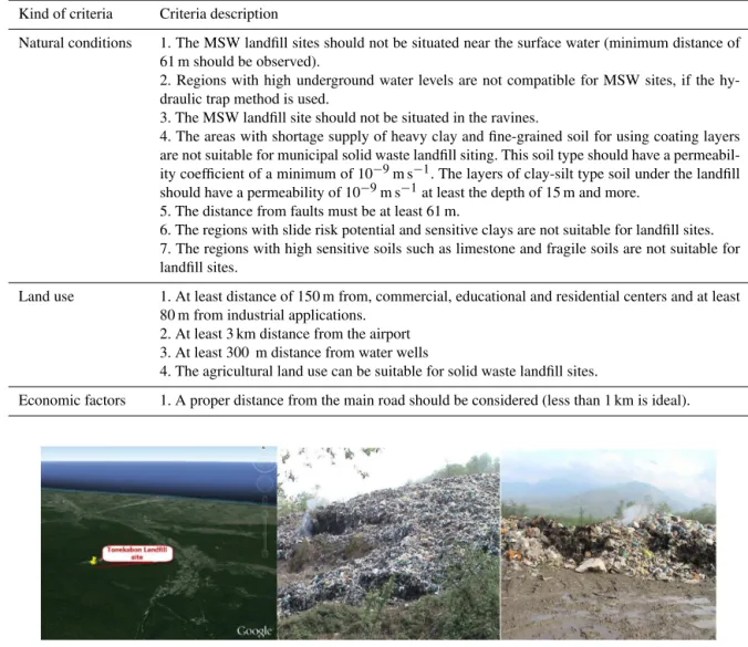
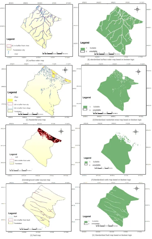
The Tonekabon region (1631.8 km2)is located in the west-ern part of Mazandaran province, on the northwest-ern edge of Iran between Ramsar and Abas Abad city (Fig. 1). The MSW landfill of Tonekabon is located at Dohezar road, 30 km south of the city in the Pordesar forest. This site has an area of over 2 ha, located at 36◦42′N, 50◦49′E at 520 m a.s.l. Located be-tween the Alborz mountain range and Caspian Sea, the study area has a temperate humid climate. The average annual pre-cipitation from the nearest meteorological station (Khoram Abad station) is equal to 994 mm, and monthly relative hu-midity is 82 %. The solid waste inputs are collected from three municipal districts (Central, Nashta, and Khoram Abad districts with 149 010 inhabitants) (Tonekabon municipality, 2014). Application of the methodology is based on the col-lection of data related to the physical environment, state and characteristics of deposit site. Data collection involved visit-ing the current deposit area as well as studyvisit-ing the existvisit-ing library information. In this study, map layers were input ac-cording to mentioned guidelines and included surface water (rivers and lakes), flood plains, geology (faults, bedrock, seis-micity), groundwater, underground water resources (springs and wells), land use (agricultural land, forest land, residential area), distance to airport, distance to residential areas, and road distance to waste production centers. At this research site, waste is dumped in the forest without applying any en-vironmental and engineering standards. The lack of proper waste management systems and the humid climate increase environmental problems at this site.
2.2 Investigation of the evaluation criteria
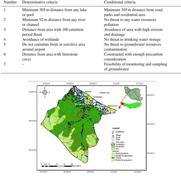
es-Table 1.Six determinative and seven conditional factors of MPCA method (Badve, 2001).
Number Determinative criteria Conditional criteria
1 Minimum 305 m distance from any lake or pool
Minimum 305 m distance from road, parks and residential area
2 Minimum 92 m distance from any river or channel
No threat to any water resources pollution
3 Distance from area with 100 retention period flood
Avoidance of area with high erosion and drainage
4 Avoidance of wetlands No threat to drinking water storage 5 Do not cumulate birds in sensitive area
around airport
No threat to groundwater resources contamination
6 Distance from area with limestone caves
Constructed with enough precaution consideration
7 – Feasibility of monitoring and sampling
of groundwater
Figure 1.Location of Tonekabon in Mazandaran province, Iran.
tablished regulations. There are many methods used through-out the world to determine appropriate landfill sites that can found in the literature (Alexakis and Apostolos, 2014; Reza-zade et al., 2014; Moeinaddini et al., 2010; Sumathi et al., 2007). Two research methods – Minnesota Pollution Con-trol Agency method and regional screening guideline – were used for suitability evaluation of the current Tonekabon land-fill site. Each system evaluates waste sites according to a set of established criteria. The Minnesota Pollution Con-trol Agency (MPCA) method, the prevalent method in land-fill site selection, was developed by the Minnesota Pollution Control Agency in 1983 (Badve, 2001). The MPCA method includes six primary determinative factors and seven sec-ondary conditional factors. The six primary determinative factors are mandatory and must be observed in landfill site selection; non-compliance with any of these six factors
elim-inates the site. The other seven factors are conditional; this means that if one of the seven factors fails to meet selection criteria but the problem can be resolved using engineering operations, there is no obstacle to site selection. Determina-tive and conditional factors utilized in the MPCA method are illustrated in Table 1. The regional screening method uses three important parameters such as natural conditions, land use, and economic factors to determine site suitability (Ball, 2004). Examples of some of the factors used are illustrated in Table 2.
2.3 Preparation and investigation of thematic maps and overlaying these maps in GISs
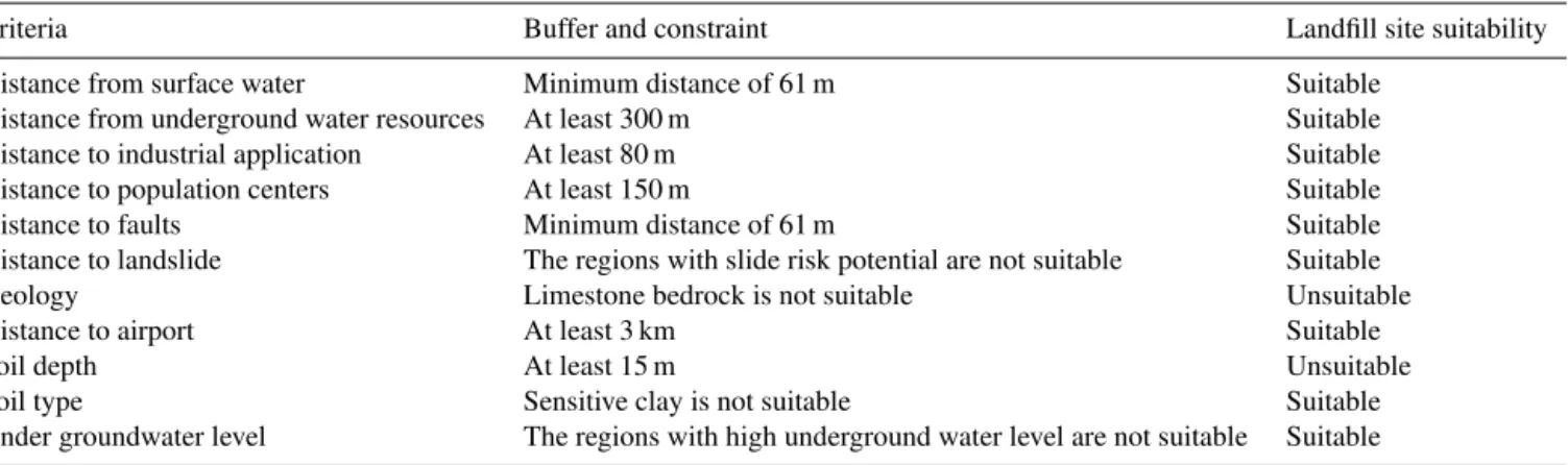
Table 2.Descriptions of the criteria used in the regional screening method.
Kind of criteria Criteria description
Natural conditions 1. The MSW landfill sites should not be situated near the surface water (minimum distance of 61 m should be observed).
2. Regions with high underground water levels are not compatible for MSW sites, if the hy-draulic trap method is used.
3. The MSW landfill site should not be situated in the ravines.
4. The areas with shortage supply of heavy clay and fine-grained soil for using coating layers are not suitable for municipal solid waste landfill siting. This soil type should have a permeabil-ity coefficient of a minimum of 10−9m s−1. The layers of clay-silt type soil under the landfill should have a permeability of 10−9m s−1at least the depth of 15 m and more.
5. The distance from faults must be at least 61 m.
6. The regions with slide risk potential and sensitive clays are not suitable for landfill sites. 7. The regions with high sensitive soils such as limestone and fragile soils are not suitable for landfill sites.
Land use 1. At least distance of 150 m from, commercial, educational and residential centers and at least 80 m from industrial applications.
2. At least 3 km distance from the airport 3. At least 300 m distance from water wells
4. The agricultural land use can be suitable for solid waste landfill sites.
Economic factors 1. A proper distance from the main road should be considered (less than 1 km is ideal).
Figure 2.Location of and conditions at the Tonekabon landfill site.
Using GISs for evaluation and selection of a proper location for landfill sites is an economical and practical method that has been used in past research (Ghanbari et al, 2011; Sumathi et al., 2007; Mahini and Gholamalifard, 2006). Over the last few years, GIS has emerged as a suitable tool for land use analysis (Malczewski, 2004). Using GIS is helpful to distin-guish between more suitable and unsuitable sites or sites that are restricted by regulations or constrained locations. The combination of findings from GIS software and field review is very useful. In this study our work considered the char-acteristics of the Tonekabon landfill site based on review of library information, past literature and application of digital maps in ArcGIS version 10.2. Most maps and data were ob-tained from the Mazandaran Management and Planning Of-fice of the Governor at a scale of 1 : 100 000. The surface and groundwater maps were obtained from the Geographic Infor-mation Centre of the Mazandaran Regional Water Organiza-tion with a scale of 1 : 250 000. The landfill site map layer
was prepared by locating the GPS coordinates of the Tonek-abon landfill site in field view and entering them as latitude and longitude in the GIS software database, and then con-verting them into a point data. In this study, the geographical and environmental conditions of the Tonekabon landfill site were first identified. Then the Minnesota Pollution Control Agency and the regional screening methods were applied to evaluate the suitability of the landfill site. In this study 12 cri-teria maps according to the evaluation cricri-teria in the MPCA method and the regional screening guidelines were used. Fig-ure 2 shows the Tonekabon landfill site location and general conditions.
2.3.1 Data and evaluation criteria
Table 3.The suitability of the Tonekabon landfill site based on MPCA method criteria.
Determinative criteria Buffer and constraint Suitability
Distance from any lake or pool Minimum 305 m Suitable
Distance from any river or channel Minimum 92 m Suitable
Distance from area with 100 retention period flood Not be situated in this area Suitable
Wetlands Avoidance Suitable
Distance from airport Do not cumulate birds in sensitive area around airport Suitable Distance from area with limestone caves Not be situated in area with limestone caves Suitable
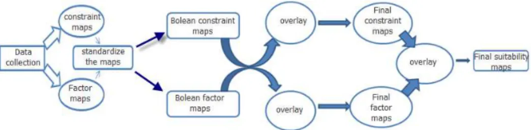
Table 4.The suitability of the Tonekabon landfill site based on the regional screening criteria.
Criteria Buffer and constraint Landfill site suitability
Distance from surface water Minimum distance of 61 m Suitable
Distance from underground water resources At least 300 m Suitable
Distance to industrial application At least 80 m Suitable
Distance to population centers At least 150 m Suitable
Distance to faults Minimum distance of 61 m Suitable
Distance to landslide The regions with slide risk potential are not suitable Suitable
Geology Limestone bedrock is not suitable Unsuitable
Distance to airport At least 3 km Suitable
Soil depth At least 15 m Unsuitable
Soil type Sensitive clay is not suitable Suitable
Under groundwater level The regions with high underground water level are not suitable Suitable
area were represented by (i) a surface water (hydrology) map which represents important environmental factors due to po-tential risk of contamination. There are no lakes or pools in the area, but there are multiple rivers in the area, and the nearest river to the MSW site is about 1.8 km away. Dis-tances of less than 61 m according to regional screening and at least 92 m based on the MPCA method are unsuitable while greater distances are suitable. (ii) An infiltration map displays the various soil types in the study area. The infiltra-tion rate is a key parameter to evaluate the risk of groundwa-ter pollution, and thus it is an important factor for landfill site selection in the study area. This map was used to estimate the groundwater level and soil types. The infiltration at this site is high and the soil texture is silt clay loam. So the high level of groundwater is not suitable. (iii) The residential area map displays the existing cities and villages. There are four towns in Tonekabon city: Khoram Abad, Shiroud, Tonekabon, and Nashtaroud. The nearest of them, Khoram Abad, is located 10 km from the study site. There are 875 villages in the study area and the closest village is 450 m from the MSW site. So the distance of less than 150 m from residential areas is not suitable for a landfill site based on regional screening leg-islation. (iv) The road network map delineates all the ma-jor and minor roads of the study area. The location of the landfill is at a distance of about 3 km from Dohezar main road. (v) The land use map shows good and medium grass-lands, gardens, agricultural grass-lands, forest and the four towns in Tonekabon city. The dominant type of land use in this area
Figure 3.Flowchart of the methodology followed in the study.
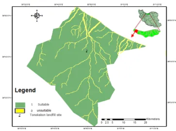
we standardized the constraint and factor map layers based on Boolean logic. So all the areas that are forbidden for land-fill development in the MPCA method and regional screen-ing guidelines and their regulations (constraints) and also all areas that fall inside the distances within which landfill de-velopment is forbidden (buffers) in the map layers have been assigned a value of 0 and all other areas have been assigned a value of 1. Thus with the reclassified module in ArcGIS soft-ware, the restricted area’s value was 0 (unsuitable area) and the other area’s (suitable area) value was 1. The GIS-based constraint mapping technique was applied to the study area. Different criteria are used to obtain GIS data sets of the buffer zone for rivers, water supply sources, fault lines, cities and flood plains. Maps represent the acceptable distance, which should be considered in site selection for different criteria using the buffer option in ArcGIS. They were produced on the basis of existing standards, which are indicated above. The areas within the buffer zones are not suitable for land-fill development and solid waste disposal. Buffer maps were generated in which the “areas of constraints” were displayed. Such areas are surrounded by residential areas, rivers, water supply sources, roads and fault lines. For example, in order to prepare the buffer for rivers under the MPCA guidelines, the rivers in our study area were identified and then a buffer distance of 92 m was established around them. In the same way, buffer zones for the other criteria such as roads, wa-ter reservoir sources and faults were created at the distances established for each of them in the two methods. A GIS-based overlay analysis of generated Boolean factor maps and Boolean constraint maps was done in order to identify the landfill site suitability. After reviewing all specified criteria from each of the guidelines, the suitability of deposit site and the study area was identified (see Figs. 4 and 5).
3 Results and discussion
After analyzing the study area with maps and field checks (see tables and figures) it was found that the Tonekabon land-fill site is suitable based on the MPCA determinative guide-lines (see Table 3), but it is unsuitable according to the re-gional screening method (see Table 4). Our study shows a conflict between the two methods. About 1555.4507 km2, equivalent to 95.32 % of the entire study area, was rated as suitable for landfill development by the MPCA. About
949.3758 km2 of the Tonekabon city, equivalent to 58.2 % of the entire study area, was rated as suitable for land-fill development based on the regional screening criteria (Figs. 6 and 7). Although the Tonekabon landfill site is ac-ceptable according to the MPCA method, due to lack of ma-chinery and necessary equipment, poorly maintained walls around the site, insufficient guards and lack of a guard house, a lack of gas and leaching controls and open air burning are some of problems at this landfill site. It is clear that the main problem at the Tonekabon landfill is non-compliance with landfill site selection standards, engineering frameworks, and design as well as lack of appropriate waste management and sanitary landfill. The problems include open-air waste burn-ing, open-pit dumpburn-ing, and uncontrolled waste disposal in landfills, which can result in negative impacts on human health and on the environment (Brevik and Burgess, 2013; Brevik and Sauer, 2015). Unfortunately hardly any of the ap-plicable criteria are applied to the Tonekabon landfill site.
Figure 5.The factor map layers used in the regional screening method and standardized maps based on Boolean logic.
to control existing landfill problems. Paying more attention to current unsanitary landfill sites will change weak points in the current landfill management system to strong points. It is important to note that the criteria utilized in the MPCA method and regional screening guidelines are for sanitary
sensi-Figure 6.The suitability of the studied area based on MPCA deter-minative criteria.
tive ecosystems, slope of the land, soil texture and infiltra-tion. Comparisons between the regional screening and the MPCA method showed that the regional screening method has more evaluation criteria to assess. As a result, fewer suit-able areas were identified in the study area. Since each of the two methods has some dos and don’ts to evaluate land-fill sites, we standardized the map layers based on Boolean logic. The primary feature of this logic is speed and easiness in performance, but at least the suitable and unsuitable lo-cations will be differentiated. Also this logic is appropriate and useful, but it has some defects. The result of Boolean logic gives only two options – appropriate or inappropriate – and it is therefore not able to prioritize between locations. To achieve the desired final result in site selection it would be better to use other multi-criteria decision-making meth-ods and to weight the criteria according to their relative im-portance based on ecological, economic and social features in each region. The evaluation of the current unsanitary land-fill sites and their implications for land degradation can open a new way to start restoration of these regions and convert them to self-sustaining and productive ecosystems in devel-oping countries, including better management approaches for sanitary landfills to decrease land degradation. Restoration of sanitary and non-sanitary landfills is necessary to mini-mize adverse impacts on the environment (Do et al., 2013). To provide scientific data for future restoration management, Chen et al. (2015) compared the ecological performances be-tween natural sites and revegetated landfill sites and showed that, during the study period, there was a gradual change in the plant communities at restored sites and an increase in biodiversity. Research has also shown that exotic plant species may be more suitable for use as pioneer species in the restoration of sanitary landfills (Wong et al., 2015b) and also pioneer native species were much better than other na-tive species (Wong et al., 2015a). Many research projects have been conducted that can be used to recover the degraded
Figure 7. The suitability of the studied area based on regional screening method.
lands at this site and convert this degraded forest to a pro-ductive ecosystem in the future (Iwai et al., 2013; Courtney and Harrington, 2012; Mahmoud and El-kader, 2014; Paz-Ferreiro et al., 2014; Mekonnen et al., 2014). This requires a multidisciplinary view of the soil system (Brevik et al., 2015) and also applied methodologies to restore soil quality (van Leeuwen et al., 2015; Zornoza et al., 2015).
4 Conclusions
Open dumping is an important cause of land and soil degradation in Iran. According to the regional screening method the Tonekabon landfill site is not acceptable, while according to the MPCA method the Tonekabon landfill site is acceptable. About 949.3758 km2, equivalent to 58.2 % of the entire study area of Tonekabon city, was determined to be suitable for sanitary landfill development based on the regional screening criteria, while about 1555.4507 km2, equivalent to 95.32 % of the entire study area, was deter-mined to be suitable using the MPCA method. The study showed fewer suitable areas for landfill development in Tonekabon city based on the regional screening method as compared to the MPCA method. Field research confirmed that inappropriate management techniques were being used at the Tonekabon landfill site and the urgent need for a restoration program.
Edited by: A. Cerdà
References
Abdoli, M. A.: Recycling of Municipal Solid Wastes, Tehran Uni-versity, Tehran, Iran, 384 pp., 2005a.
Apo survey on Solid Waste, the Asian Productivity Organization, Mumbai, India, 92–117, 2005b.
Aliowsati, F., Monavari, M. and Omrani, G. A.: The evaluation of Karaj municipal solid waste landfill site with Local and regional screening, Environ. Sci. Technol., 15, 85–96, 2013.
Alexakis, D. D. and Apostolos, S.: Integrated GIS and remote sens-ing analysis for landfill sittsens-ing in Western Crete, Greece, Envi-ronmental Earth Sciences, 72, 467–482, 2014.
Al-Karaki, G. N.: Utilization of treated sewage wastewater for green forage production in a hydroponic system, Emir. J. Food Agric., 23, 80–94, doi:10.9755/ejfa.v23i1.5315, 2011.
Ball, J. M.: Aspects of landfill site selection, Proceedings of the Institute of Waste Management, South Africa Waste Conference 2004, 11–15 October, Sun City, South Africa, 2004.
Batjes, N. H.: Projected changes in soil organic carbon stocks upon adoption of recommended soil and water practices in the Upper Tana River Catchment, Kenia, Land Degrad. Dev., 25, 278–287. doi:10.1002/ldr.2141, 2014.
Biro, K., Pradhan, B., Buchroithner, M., and Makeschin, F.: Land use/Land cover change analysis and it’s impact on soil properties in the northern part of Gadarif region, Sudan, Land Degrad. Dev., 24, 90–102, doi:10.1002/ldr.1116, 2013.
Brevik, E. C. and Burgess, L. C.: Soils and human health, Boca Raton: CRC Press, Boca Raton, FL, USA, 3–28, 2013.
Brevik, E. C., Cerdà, A., Mataix-Solera, J., Pereg, L., Quinton, J. N., Six, J., and Van Oost, K.: The interdisciplinary nature of SOIL, SOIL, 1, 117–129, doi:10.5194/soil-1-117-2015, 2015. Brevik, E. C. and Sauer, T. J.: The past, present, and future of soils
and human health studies, SOIL, 1, 35–46, doi:10.5194/soil-1-35-2015, 2015.
Chang, N., Parvathinathan, E., and Breeden, G.: Combining GIS with fuzzy multi criteria decision-making for landfill siting in a fast-growing urban region, J. Environ. Manage., 87, 139–153, 2008.
Chen, X. W., Wong, J. T. F., Mo, W. Y., Man, Y. B., Ng, C. W. W., and Wong, M. H.: Ecological Performance of the Restored South East New Territories (SENT) Landfill in Hong Kong (2000– 2012), Land Degrad. Dev., doi:10.1002/ldr.2366, 2015. Christensen, T. H., Cossu, R., and Stegmann, R.: Landfilling of
waste: Leachate, 1st edn., Taylor and Francis, London, UK, 1992. Courtney, R. and Harrington, T.: Growth and nutrition of Holcus Lanatusin bauxite residue amended with combinations of spent mushroom compost and gypsum, Land Degrad. Dev., 23, 144– 149, doi:10.1002/ldr.1062,2012.
Davami, A. H., Moharamnejad, N., Monavari, S. M., and Shariat, M.: An Urban Solid Waste Landfill Site Evaluation Process In-corporating GIS in Local Scale Environment: A Case of Ahvaz City, Iran, Int. J. Environ Res., 8, 1011–1018, 2014.
De Souza, R. G., Da Silva, D. K. A., De Mello, C. M. A., Goto, B. T., Da Silva, F. S. B., Sampaio, E. V. S. B., and Maia, L. C.: Arbuscular mycorrhizal fungi in revegetated mined dunes, Land Degrad. Dev., 24, 147–155, doi:10.1002/ldr.1113, 2013. Dimitriou, F., Karaouzas, I., Saratakos, K., Zacharias, I., Bogdanos,
K., and Diapoulis A.: Groundwater risk assessment at a heavily industrialised catchment and the associated impacts on a peri-urban wetland, J. Environ. Manage., 88, 526–538, 2008. Do, Y., Kim, J. Y., Kim, G. Y., and Joe, G. J.: Importance of
closed landfills as green space in urbanized areas: ecological
assessment using carabid beetles, Landsc. Ecol. Eng., 1, 1–8, doi:10.1007/s11355-013-0223-x, 2013.
Donevska, K., Jovanovski, J., Jovanovski, M., and Pelivanoski, P., Analyses of Environmental Impacts of Non Hazardous Regional Landfills in Macedonia, J. sustain. Dev. Energy Water Environ. Syst., 1, 281–290, doi:10.13044/j.sdewes.2013.01.0021, 2013. Farzaneh, G.: The study of environmental impact assessment of
solid waste landfill in west of Golestan Province, The Environ-ment, 42, 59–65, 2003 (in Persian).
Ganjegunte, G. K., Sheng, Z., and Clark, J. A.: Soil salinity and sodicity appraisal by electromagnetic induction in soil-sirrigated to grow cotton, Land Degrad. Dev., 25, 228–235, doi:10.1002/ldr.1162, 2014.
Ghanbari, F., AminSharee, F., Monavai, M., and Zaredar, N.: A new method for environmental site assessment of urban solid waste landfills, Environ. Monit. Assess., 184, 1221–1230, doi:10.1007/s10661-011-2034-6, 2012.
Giménez Morera, A., Ruiz Sinoga, J. D., and Cerdà, A.: The im-pact of cotton geotextiles on soil and water losses in Mediter-ranean rainfed agricultural land, Land Degrad. Dev., 210–217, doi:10.1002/ldr.971, 2010.
Glynn, H. J.: Environmental science and engineering, Prentice-Hall, New Delhi, 2004.
Guenon, R., Vennetier, M., Dupuy, N., Roussos, S., Pailler, A., and Gros, R.: Trends in recovery of mediterraniean soil chemical properties and microbiological activities after infre-quent and freinfre-quent wildfire, Land Degrad. Dev., 24, 115–128, doi:10.1002/ldr.1109, 2013.
Hagerty, D. J., Pavoni, J. L., and Heer, J. E.: Solid waste manage-ment, Litton, New York, USA, 1997.
Hernandez, A. J., Adarve Alcazar, M. J., and Pastor, J.: Some im-pacts of urban waste landfills on Mediterranean soils, Land De-grad. Dev., 9, 21–33, 1998.
Iranian Statistics Centre, General Census of Population and Hous-ing of Mazandaran province, 2010.
Iwai, C. B., Oo, A. N., and Saenjan, P.: Soil properties and maize growth in saline and non-saline soils using Cassava-industrial waste compost and vermin compost with or without earthworms, Land Degrad. Dev., doi:0.1002/ldr.2208, 2013.
Keesstra, S. D., Geissen, V., van Schaik, L., Mosse., K., and Piiranen, S.: Soil as a filter for groundwater quality, Cur-rent Opinions in Environmental Sustainability, 4, 507–516. doi:10.1016/j.cosust.2012.10.007, 2012a.
Keesstra, S. D., Kondrlova, E., Czajka, A., Seeger, M., and Maroulis, J.: Assessing riparian zone impacts on water and sedi-ment movesedi-ment: a new approach, Neth. J. Geosci., 91, 245–255, doi:10.1017/S0016774600001633, 2012b.
Keesstra, S. D., Bruijnzeel, L. A., and Van Huissteden, J.: Meso-scale catchment sediment budgets: combining field surveys and modeling in the Dragonja catchment, southwest Slovenia, Earth Surf. Proc. Land., 34, 1547–1561, doi:10.1002/esp.1846, 2009. Keesstra, S. D.: Impact of natural reforestation on floodplain
sedi-mentation in the Dragonja basin, SW Slovenia, Earth Surf. Proc. Land., 32, 49–65, doi:10.1002/esp.1360, 2007.
Leao, S., Bishop, I., and Evans, D.: Spatial-Temporal model for de-mand and allocation of waste landfills in growing urban region, Computers, Environ. Urban Sys., 28, 353–385, 2004.
León, J., Seeger, M., Badía, D., Peters, P., and Echeverría, M. T.: Thermal shock and splash effects on burned gypseous soils from the Ebro Basin (NE Spain), Solid Earth, 5, 131–140, doi:10.5194/se-5-131-2014, 2014.
Mahini, S. and Gholamalifard, M.: Siting MSW landfills with a weighted linear combination methodology in a GIS environment, J. Sci. Technol., 3, 435–446, 2006.
Mahmuod, E. and El-Kader, N. A.: Heavy metal immobilization in contaminated soils using phosphogypsum and rice straw com-post, Land Degrad. Dev., doi:10.1002/ldr.2288, 2014.
Malczewski, J.: GIS-based land-use suitability analysis: a critical overview, Prog. Plann., 62, 3–65, 2004.
Mandal, D. and Sharda, V. N.: Appraisal of soil erosion risk in the Eastern Himalayan region of India for soil conservation plan-ning, Land Degrad. Dev., 24, 430–437, doi:10.1002/ldr.1139, 2013.
Mekonnen, M., Keesstra, S. D., Stroosnijder, L., Baartman, J. E. M., and Maroulis, J.:. Soil conservation through sediment trapping: a review, Land Degrad. Dev., doi:10.1002/ldr.2308, 2014. Mohawesh, Y., Taimeh, A., and Ziadat, F.: Effects of land use
changes and conservation measures on land degradation un-der a Mediterranean climate, Solid Earth Discuss., 7, 115–145, doi:10.5194/sed-7-115-2015, 2015.
Moeinaddini, M., Khorasani, N., Danehkar, A., Darvishsefat, A. A., and Zienalyan, M.: Siting MSW landfill using weighted linear combination and analytical hierarchy process (AHP) methodol-ogy in GIS environment (case study: Karaj), Waste Manage., 30, 912–920, doi:10.1016/j.wasman.2010.01.015, 2010.
Monavari, M. and Shariat, M.: Evaluation of landfill site selection standards in Rasht, Environ. Sci. Technol., 1, 27–34, 2000. Monavari, M. and Arbab, P.: The environmental evaluation of
mu-nicipal solid waste landfills of the Tehran province, Environm. Sci., 2, 1–8, 2005.
Monavari, M., Khorasani, N., Omrani, G. A., and Arbab, P.: The study of municipal solid waste landfills in Tehran using Oleckno method, Environ. Sci. Technol., 1, 37–46, 2007.
Mor, S., Ravindra, K., Dahiya, R.P., and Chandra, A.: Leachate characterization and assessment of ground water pollution near municipal solid waste landfill site, Environ. Monit. Assess., 118, 435–456, doi:10.1007/s10661-006-1505-7, 2006.
Morugán-Coronado, A., Arcenegui, V., García-Orenes, F., Mataix-Solera, J., and Mataix-Beneyto, J.: Application of soil quality indices to assess the status of agricultural soils irrigated with treated wastewaters, Solid Earth, 4, 119–127, doi:10.5194/se-4-119-2013, 2013.
Mukhopadhyay, S. and Maiti, S. K.: Soil CO2flux in grassland, af-forested land and reclaimed coal mine overburned dumps: A case study, Land Degrad. Dev., 25, 216–227, doi:10.1002/ldr.1161, 2014.
Municipality of Tonekabon: Solid waste management section re-port, Mazandaran province governor, Iran, 2014.
Nema, A. K., Datta, M., and Singh, R. K.: A new system for ground water contamination hazard rating of landfills, J. Environ. Man-age., 91, 344–357, 2009.
Novara, A., Gristina, L., Guaitoli, F., Santoro, A., and Cerdà, A.: Managing soil nitrate with cover crops and buffer strips in
Si-cilian vineyards, Solid Earth, 4, 255–262, doi:10.5194/se-4-255-2013, 2013.
Novara, A., Gristina, L., Saladino, S. S., Santoro, A., and Cerdà, A.: Soil erosion assessment on tillage and alternative soil man-agements in a Sicilian vineyard, Soil Till Res., 117, 140–147, 2011.
Olang, L. O., Kundu, P. M., Ouma, G., and Fürst, J.: Impact of land cover change scenarios on storm runoff generation: A basis for management of the Nyando basin, Kenya, Land Degrad. Dev., 25, 267–277, doi:10.1002/ldr.2140, 2014.
Pallavicini, Y., Alday, J. G., Martínez-Ruiz, C. F.: Factors affect-ing herbaceous richness and biomass accumulation patterns of reclaimed coal mines, Land Degrad. Dev., doi:10.1002/ldr.2198, 2014.
Paz-Ferreiro, J., Mendez, J., Tarquis, A. M., Cerda, A., and Gasco, G.: Preface: environmental benefits of biochar, Solid Earth, 5, 1301–1303, doi:10.5194/se-5-1301-2014, 2014. Raman, N. and Sathiana, R.: Impact of solid waste effects on ground
water and soil quality nearer to Pallavaram solid waste landfill site in Chennai, Rasayan J., 1, 828–836, 2008.
Rao, P. J., Brinda, V., Rao, B. S., and Harikrihna, P.: Selection of landfill sites for solid waste management in and around Visakha-patnam City – a GIS approach, Asian J. Geo Inf., 7, 5–41, 2007. Rezazadeh, M., Sadati Seyedmahalleh, E., Sadati Seyedmahalleh, E., Mehrdadi, N., and Golbabaei Kootenaei, F.: Landfill site se-lection for Babol using Fuzzy logic method, Journal of Civil En-gineering and Urbanism, 4, 261–265, 2014.
Salimi, M., Ebrahimi, A., and Salimi, A.: Evaluation of new lo-cation of Isfahan’s sanitary landfill site with Oleckno method, International Journal of environmental health engineering, 2, doi:10.4103/2277-9183.122408, 2013.
Shaylor, H., McBride, M., and Harrison, E.: Sources and Impacts of contaminants in Soil, Cornell University, available at: http: //cwmi.css.cornell.edu, 2009.
Sumathi, V. R., Natesan, U., and Chinmoy, S.: GIS-based approach for optimized siting of municipal solid waste landfill, Waste Manage., 28, 2146–2160, doi:10.1177/0734242X0302100310, 2008.
Srinivasarao, C. H., Venkateswarlu, B., Lal, R., Singh, A. K., Kundu, S., Vittal, K. P. R., Patel, J. J., and Patel, M. M.: Long-term manuring and fertilizer effects on depletion of soil organic carbon stocks under pearl millet-cluster bean-castor rotation in western India, Land Degrad. Dev., 25, 173–183, doi:10.1002/ldr.1158, 2014.
van Leeuwen, J. P., Lehtinen, T., Lair, G. J., Bloem, J., Hemerik, L., Ragnarsdóttir, K. V., Gísladóttir, G., Newton, J. S., and de Ruiter, P. C.: An ecosystem approach to assess soil quality in organically and conventionally managed farms in Iceland and Austria, SOIL, 1, 83–101, doi:10.5194/soil-1-83-2015, 2015.
Wang, L.: Assessment of groundwater vulnerability to landfill leachate induced arsenic contamination in Maine, US. Intro GIS Term Project Final Report, Dept. of Civil and Environmental En-gineering, 2007.
Wang, G., Qin, L., Li, G., and Chen, L.: Landfill site selec-tion using spatial informaselec-tion technologies and AHP: A case study in Beijing, China, J. Environ. Manage., 90, 2414–2421, doi:10.1016/j.jenvman.2008.12.008, 2009.
on Top of an Engineered Landfill, Hong Kong: Restoration Pro-gramme, Land Degrad. Dev., doi:10.1002/ldr.2380, 2015a. Wong, J. T.-F., Chen, X.-W., Mo, W.-Y., Man, Y.-B., Wang-Wai Ng,
C., and Wong, M.-H.: Restoration of plant and animal communi-ties in a sanitary landfill: A ten years case study in Hong Kong, Land Degrad. Dev., doi:10.1002/ldr.2402, 2015b.
Zhao, G., Mu, X., Wen, Z., Wang, F., and Gao, P.: Soil erosion, conservation, and Eco-environment changes in the Loess Plateau of China. Land Degrad. Dev., 24, 499–510, doi:10.1002/ldr.2246, 2013.