Programa de Pós-Graduação em Geodinâmica e Geofísica
DISSERTAÇÃO DE MESTRADO
CONTROLE ESTRUTURAL DO CARSTE
HIPOGÊNICO TOCA DA BOA VISTA
–
TOCA DA
BARRIGUDA NA FORMAÇÃO SALITRE, NORTE DO
CRÁTON SÃO FRANCISCO
Autora:
RENATA DE ARAÚJO ENNES SILVA
Orientador:
Dr. FRANCISCO HILÁRIO REGO BEZERRA
Co-orientador:
Dr. FRANCISCO CEZAR COSTA NOGUEIRA
Dissertação n.º 148 /PPGG.
PROGRAMA DE PÓS-GRADUAÇÃO EM GEODINÂMICA E GEOFÍSICA
DISSERTAÇÃO DE MESTRADO
CONTROLE ESTRUTURAL DO CARSTE
HIPOGÊNICO TOCA DA BOA VISTA
–
TOCA DA
BARRIGUDA NA FORMAÇÃO SALITRE, NORTE DO
CRÁTON SÃO FRANCISCO
Autor:
Renata de Araújo Ennes Silva
Dissertação apresentada em 13 de julho de 2015, ao Programa de Pós-Graduação em Geodinâmica e Geofísica – PPGG, da Universidade Federal do Rio Grande do Norte - UFRN como requisito à obtenção do Título de Mestre em Geodinâmica e Geofísica, com área de concentração em Geodinâmica.
Comissão Examinadora:
Dr. Francisco Hilário Rego Bezerra (orientador)
Dr. Narendra Srivastava (membro interno)
Dra. Elissandra Moura Lima (membro externo)
Setor de Informação e Referência
Catalogação da Publicação na Fonte. UFRN / Biblioteca Central Zila Mamede
Silva, Renata de Araújo Ennes.
Controle estrutural do carste hipogênico Toca da Boa Vista – Toca da Barriguda na Formação Salitre, norte do Cráton São Francisco / Renata de Araújo Ennes Silva. – Natal, RN, 2015.
58 f.
Orientador: Francisco Hilário Rego Bezerra. Co-orientador: Francisco Cezar Costa Nogueira.
Dissertação (Doutorado em Geologia) – Universidade Federal do Rio Grande do Norte. Centro de Ciências Exatas e da Terra. Programa de Pós-Graduação em Geodinâmica e Geofísica.
1. Carste – Dissertação. 2. Carste hipogênico - Dissertação. 3. Formação salitre - Dissertação. 4. Anticlinais - Dissertação. 5. Toca da Boa Vista – Dissertação. I. Bezerra, Francisco Hilário Rego. II. Nogueira, Francisco Cezar Costa. III. Título.
RESUMO
A porosidade e permeabilidade em zonas fraturadas podem aumentar devido a fluidos ascendentes em sistemas cársticos. Este trabalho apresenta uma análise estrutural de duas cavernas hipogênicas da América do Sul. A área de estudo inclui a Toca da Boa Vista (TBV) e Toca da Barriguda (TBR), que possuem 107 km e 34 km respectivamente. Este sistema cárstico ocorre em carbonatos neoproterozoicos da Formação Salitre, porção norte do cráton São Francisco, nordeste do Brasil. Durante o Brasiliano foram formados cinturões de dobramento ao redor do cráton com padrão compressivo desenvolvido entre 740-580 Ma. A metodologia inclui análise dos mapas de condutos do Grupo Bambuí de Pesquisas Espeleológicas, a partir dos quais foram elaborados mapas estruturais das cavernas e comparação com a deformação regional. Os softwares usados para processamento de dados estruturais incluiram: Openstereo, Stereonet 8, Georient 9.4.5 e Tectonic FP. A análise da deformação do sistema TBV-TBR e o contexto regional da Formação Salitre permitiu concluir que: (1) Os condutos se desenvolveram ao longo de eixos de anticlinais N-S e ENE-WSW para E-W; (2) O desenvolvimento do carste foi formado pela dissolução de juntas subverticais; (3) O primeiro evento de dobramento F1 corresponde à uma compressão de direção N-S, e, o segundo evento F2 está relacionado a compressão E-W. Ambos os eventos ocorreram no Brasiliano. Portanto, é possível confirmar que existe relação direta dos fluidos ascendentes e dissolução hipogênica com a deformação regional.
ABSTRACT
Porosity and permeability along fractured zones of carbonate rocks could be enhanced by ascending fluid flow in karst regions. This work presents a structural analysis of two largest hypogenic caves in South America. The study area encompasses the Toca da Boa Vista (TBV) and Toca da Barriguda (TBR) caves, which are 107 km and 34 km long, respectively. This karst system occurs in the Neoproterozoic carbonates of the Salitre Formation, in the northern part of the São Francisco craton, northeast of Brazil. The fold belts around and at the craton edges were deformed during the Brasiliano orogeny in a compressive setting at 740-580 Ma. Methodology includes analysis of maps of conduits available by Bambuí Group of Speleological Research, which were used to construct structural maps of caves and allowed comparison to regional deformation. The following softwares were used to process structural data: Openstereo, Stereonet 8, Georient 9.4.5 e Tectonic FP. Analysis of deformation of TBV-TBR system and the regional context of Salitre Formation allowed to conclude that: (1) Cave passages developed subhorizontally along N-S and ENE-WSW to E-W-oriented anticlines hinges; (2) Karst development were formed by dissolution of subvertical joints; (3) The first folding event F1 corresponds to a N-S-trending compression, and the second event F2, is related to E-W-compression. Both events were developed during Brasiliano event. So, it is possible to confirm that fluid flow and related dissolution pathways have a close relationship with regional deformation.
AGRADECIMENTOS
Agradeço imensamente a todos os que contribuíram de forma direta ou indireta para a conclusão desta dissertação de mestrado.
À minha família, pelo apoio e amor incondicional.
À Universidade Federal do Rio Grande do Norte e ao Programa de Pós-Graduação em Geodinâmica e Geofísica, pela excelência em geologia e oportunidade de ingressar no mestrado.
À Petrobras pelo investimento e incentivo à pesquisa relacionada a regiões cársticas, através do Projeto Porocarste.
À Capes pelo auxílio financeiro ao longo de todo o período do curso.
Ao professor Dr. Francisco Hilário Rego Bezerra pela disponibilidade e competência na orientação, pelas discussões e aprendizado ao longo do curso.
Ao professor Dr. Francisco Cezar Costa Nogueira, pelo apoio na pesquisa. Ao professor Dr. Venerando Eustáquio pelas conversas e conselhos.
À Nilda pela disposição e eficiência para ajudar nas questões relacionadas ao programa de pós-graduação.
À Tarik Sousa, à Maria de Fátima, Mikaele, Rafael e aos colegas da pós-graduação Natasha, Ingrid, Juliana, Jean, Guilherme e Luis, pelo apoio e palavra amiga sempre que necessário.
A Lorenna, Vinicius e Alysson pela ajuda na elaboração de gráficos e ilustrações.
A todos da turma de Geologia de Campo 2 (2014.2), por permitirem que a experiência em docência se tornasse realidade.
ÍNDICE
RESUMO ii
ABSTRACT iii
AGRADECIMENTOS iv
ÍNDICE v
ÍNDICE DE FIGURAS vi LISTA DE SÍMBOLOS E ABREVIATURAS viii
1
–
Introdução
10
1.1 – Justificativa 10 1.2 – Objetivo e localização da área 10 1.3 – Metodologia 11
2 - Geologia Regional
15
2.1 – O Cráton São Francisco 15 2.2 – Geologia Local 16 2.3 – Estratigrafia 16 2.4 – Tectônica Regional 18
3
–
Revisão bibliográfica sobre controle estrutural do
carste
21
4 - Artigo
274.1 – Introduction 30 4.2 – Geological setting 31
4.2.1 Tectonic structures and stratigraphy 31
4.2.2 The karst system 33
4.3 – Methods 34
4.4 – Results 35
4.4.1 General cave features 35
4.4.2 Azimuthal analysis of cave passages in map view 35
4.4.3 Fold pattern in the caves 37
4.4.4 The joint and fault pattern 40
4.5 – Discussion 43
5
–
Discussões e Conclusões
51ÍNDICE DE FIGURAS
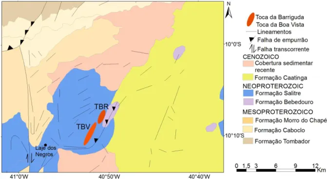
Figura 1.1: Cráton São Francisco e imagem Landsat 8 com localização da Toca
da Boa Vista e Toca da Barriguda, (USGS, 2013). 11
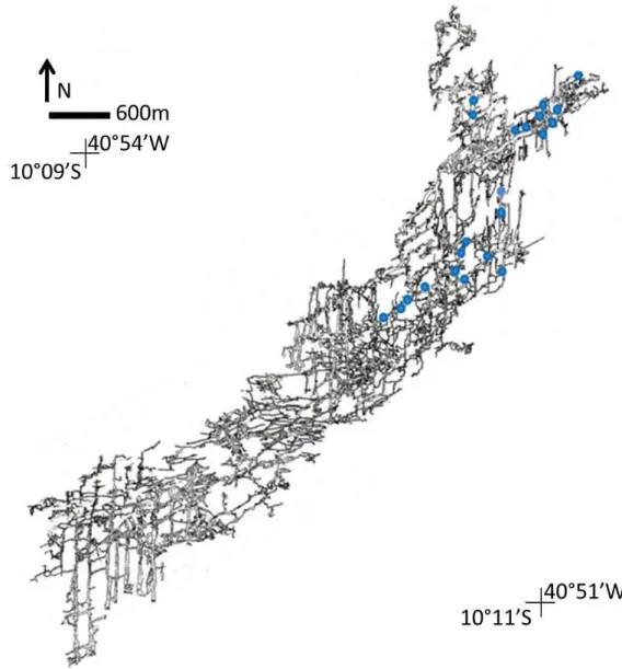
Figura 1.2: Mapa Toca da Boa Vista e pontos visitados (em azul), mapa cedido
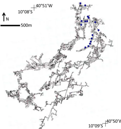
pelo (Grupo Bambuí de Pesquisas Espeleológicas, 2013). 12 Figura 1.3: Mapa Toca da Barriguda e pontos visitados (em azul), mapa cedido
pelo (Grupo Bambuí de Pesquisas Espeleológicas, 2013). 13 Figura 2.1: Cráton São Francisco, (modificado de Alkmin et al., 1993). 15
Figura 2.2: Mapa geológico da área de estudo. (Modificado de Bizzi et al., 2003). 16
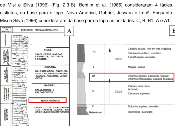
Figura 2.3: Colunas estratigráficas Formação Salitre. A) Bonfim et al., 1985, B) Misi e Silva, 1996. Subunidades onde ocorrem sistema cárstico TBV-TBR estão em vermelho.
17
Figura 2.4: Faixa Riacho do Pontal e área estudada em vermelho (Retirado de
Dominguez, 1993). 19
Figura 3.1: Exemplos de mapas estruturais em regiões cársticas, em Tsanfleurum-Sanetsch, Alpes Suíços (Gremaud et al., 2009).
22
Figura 3.2: Vista em planta do carste Piani-Eterni, estruturas em superfície e subsuperfície. Em vermelho, os condutos ao longo da direção PE-10, estrutura tectônica não reconhecida em superfície. À direita, diagrama de roseta (Sauro et al., 2013).
23
Figure 4.1: (A) The South American continent and location of the São Francisco Craton in black; (B) main lithostratigraphic units of the São Francisco Craton and surrounding folding belts (modified from Alkmin et al., 1993). Key: 1, Archean-Proterozoic basement, 2 – Mesoproterozoic sedimentary rocks of the Espinhaço Supergroup, 3 – Neoproterozoic rocks of the São Francisco Supergroup, 4 –
Phanerozoic sedimentary covers, 5 – Neoproterozoic Folding belts, 6 – Structural Lineaments.
31
Figure 4.2: Geological map of the northern part of the São Francisco Craton, including major lithostratigraphic units and tectonic structures (simplified from Bizzi et al., 2003).
32
Figure 4.3: Geological map of study area and location of the TBV-TBR caves. 33
Figure 4.4: Map of passages of the TBV and TBR caves and rose diagrams of cave-passage length and orientation. (a), (b), (c), (d) and (e) are structural domains of caves. We simplified cave maps from the Bambuí Group of Speleological Research.
36
Figure 4.5: Map of cave passages and tectonic structures of the cave system (TBV): (A) passage map and (B) structural map of the eastern part of the TBV cave; and (C) stereoplots of sedimentary bedding, which are located in (B).
37
Figure 4.6: Map of cave passages and tectonic structures of the cave system (TBR): (D) passage map of and (E) structural map of the eastern part of the TBR cave; (F) are stereoplots of sedimentary bedding, which are located in (E).
38
Figure 4.7: Cumulative fold data: (A) cumulative pattern of sedimentary bedding and the superposed fold pattern observed in stereoplot; (C) cumulative data of fold axes. (B) and (D) contour projection of fold axes.
Figure 4.8: Cave passages formed along anticline hinges: (A), (C) corresponds to the photo; (B),(D) represent a draft where (1) - (5) are the sedimentary bedding and the sterereoplots are ciclographic and poles projection and (n) is the number of measures.
39
Figure 4.9: Main generation of stylolites observed in the TBV-TBR cave system: (A) and (B) are stylolites of the F1 phase; (C) shows stylolites of F2 phase; (D) shows cross-cutting relations of stylolites of F1 (blue) and F2 (red).
41
Figure 4.10: Rose diagram of mode I joints from both caves indicating NW-trending joints associated with F1 folds and E-W-NW-trending joints related to F2 folds.
42
Figure 4.11: Mode I and conjugate joints in the TBV cave: (A) and (B) ladder pattern of F1 and F2 phase joints along which dissolution occurs. In both cases F1 joints tend N-S and are the longest fractures. (C) is a photo and (D) drawing of mode I extensional and conjugates joints.
42
Figure 4.12: Faults zones cutting across folds in the cave passages: (A) is a normal fault NW-SE, (B) is a tension gashes from a normal fault NW-SE, (C) is a fault and damage zone with N-S trending and (D) is en echelon fault with E-W trending.
43
Figure 4.13: 3D sketch of superposed fold pattern in the TBV-TBR cave system. (A) corresponds to the units (1) coarse to medium grainstone, (2) fine grainstone with chert nodules, (3) microbial carbonate, (4) interbedded fine siliciclastics and marls, (5) grainstone with chert layers. (B) represents the directions of stylolites and fractures in different phases (F0, F1 and F2).
LISTA DE SÍMBOLOS E ABREVIATURAS
m Metros km Quilômetro
1
–
Introdução
1.1 –JustificativaO conceito de carstificação é facilmente reconhecido em cavernas epigênicas, onde águas meteóricas dissolvem rochas aflorantes permitindo o desenvolvimento de cavidades devido a recarga em superfície. Nas últimas duas décadas, diversos trabalhos mostraram um novo tipo de carstificação: a hipogênica. Esta, é formada em condições semi-confinadas e sem relação direta com a superfície (Klimchouk, 2012). Além disso, a recarga é devido à formação solúvel subjacente e presença de fluidos ascendentes com H2S e fluidos hidrotermais. Trabalhos pioneiros como os de Ford e Williams (1989) e Worthington e Ford (1995) definiram que cavernas hipogênicas podem se desenvolver por meio de fluidos hidrotermais e pela oxidação de H2S. Palmer (2000a) apresentou definição mais ampla, na qual “cavernas hipogênicas se formam pela água, com agressividade produzida em profundidade e, independente de relação com a superfície ou fontes de CO2ou outras fontes ácidas”. A agressividade da água é um atributo transitório que pode ser devido a profundidade ou ser adquirido a partir de formação solúvel.
O estudo do carste tem uma crescente aplicação na indústria do petróleo. Rochas carbonáticas deformadas são excelentes reservatórios. Quando estão em áreas carstificadas exibem certa complexidade devido ao padrão estrutural e a distribuição estratigráfica. A análise da distribuição de falhas e juntas nestas regiões pode auxiliar no entendimento da carstificação e desenvolvimento de reservatórios carbonáticos. As falhas podem controlar esses sistemas (Bezerra et al., 2007) e funcionar como canais para que fluidos gerados em superfície ou subsuperfície produzam dissoluções e cavernas epigênicas ou hipogênicas. Assim, torna-se importante o levantamento e estudo de estruturas geológicas que apresentem relação com a formação e evolução de sistemas cársticos.
1.2 – Objetivo e Localização da Área
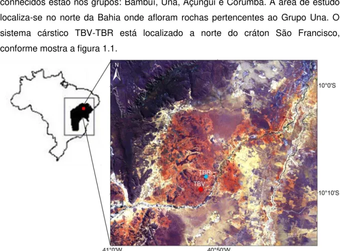
Karmann (1994) estimou para o Brasil uma área aproximada de rochas carbonáticas carstificadas de 425.000 a 600.000 km2. Alguns carstes brasileiros conhecidos estão nos grupos: Bambuí, Una, Açungui e Corumbá. A área de estudo localiza-se no norte da Bahia onde afloram rochas pertencentes ao Grupo Una. O sistema cárstico TBV-TBR está localizado a norte do cráton São Francisco, conforme mostra a figura 1.1.
Figura 1.1: Cráton São Francisco e imagem Landsat 8 com localização da Toca da Boa Vista e Toca da Barriguda, (USGS, 2013).
A soma dos condutos da TBV (107 km) a coloca como uma das maiores cavernas da América do Sul (Auler e Smart, 2003). A TBR tem 34 km, considerando também a soma dos condutos. Estas cavernas se localizam na região semi-árida do nordeste do Brasil, onde a taxa de precipitação é baixa (490 mm) e a vegetação predominante é a de caatinga (Auler e Smart, 1999).
1.3 – Metodologia
O levantamento e análise das feições estruturais foram realizados na porção setentrional das cavernas TBV-TBR (Fig. 1.2 e 1.3). Esta porção foi estudada devido ao acesso, que se torna complicado em alguns setores, e, ao tempo necessário para percorrer toda a extensão das cavernas. A metodologia utilizada neste trabalho inclui dados de subsuperfície, que inclui todo o levantamento de estruturas e morfologia nas cavernas.
foram utilizados para comparação com os dados estruturais levantados em subsuperfície. Foram medidos acamamento sedimentar, falhas e juntas. O termo
“junta” foi usado quando não foi observado movimento entre blocos, “falha” quando foi observada movimentação e fraturas quando não foi possível diferenciar. Os softwares utilizados para processamento dos dados foram: Openstereo, Stereonet 8, Georient 9.4.5 e TectonicsFP. O Openstereo, Stereonet 8 e TectonicsFP foram usados para elaborar projeções ciclográficas e projeções polares, o Georient 9.4.5 foi utilizado para geração de diagramas de roseta.
2
–
Geologia Regional
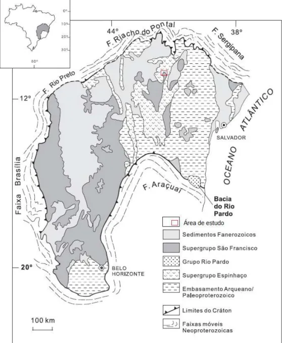
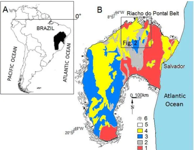
2.1 – Cráton São FranciscoA área em estudo situa-se dentro da província estrutural cráton São Francisco (Almeida, 1977), no contexto da plataforma sul-americana. O interior do cráton é composto por unidades do embasamento e coberturas cratônicas proterozoicas e fanerozoicas (Fig. 2.1). Os limites geológicos do cráton são representados por cinturões de dobramento (Alkmin et al., 1993), acrescidos ao terreno pelo ciclo Brasiliano, que incluem as faixas: Riacho do Pontal e Sergipana a norte e nordeste, Araçuaí ao sudeste, Brasília a oeste e Rio Preto ao noroeste (Fig. 2.1).
2.2 – Geologia Local
As rochas que afloram na região estão representadas na Figura 2.2 e estão incluídas no Supergrupo Espinhaço (Proterozoico Médio), Supergrupo São Francisco (Proterozoico Superior) e formações recentes do cráton São Francisco. O Supergrupo Espinhaço é composto pelo Grupo Paraguaçu e pelas formações Tombador, Caboclo e Morro do Chapéu. O Supergrupo São Francisco é composto pelos grupos Bambuí e Una. Na porção inferior do Grupo Una ocorre a Formação Bebedouro, composta por diamictitos, pelitos e grauvacas depositados em ambiente de sedimentação glácio-marinha (Guimarães, 1996) e transportados de leste para oeste, por correntes de gelo e icebergs. Na porção superior encontra-se a Formação Salitre. A Formação Salitre é composta por uma sequencia carbonática de quase 1000 m de espessura, com deposição de diferentes litofácies carbonáticas em um mar epicontinental com influência de marés e ondas.
Fig. 2.2: Mapa geológico da área de estudo. (Modificado de Bizzi et al., 2003).
A idade da Formação Salitre é de 600-670 Ma (Misi e Veizer, 1996) de acordo com datação 87Sr/86Sr. Dados bioestratigráficos a partir de posições de estromatólitos colocam a formação entre o Vendiano Superior e o Rifeano (Srivastava, 1986).
2.3- Estratigrafia
deglaciação (Formação Bebedouro). Duas classificações são propostas para esta formação, uma apresentada por Bonfim et al., 1985 (Fig. 2.3-A) e outra mais recente de Misi e Silva (1996) (Fig. 2.3-B). Bonfim et al. (1985) consideraram 4 fácies distintas, da base para o topo: Nova América, Gabriel, Jussara e Irecê. Enquanto Misi e Silva (1996) consideraram da base para o topo as unidades: C, B, B1, A e A1.
Figura 2.3: Colunas estratigráficas Formação Salitre. A) Bonfim et al., 1985, B) Misi e Silva, 1996. Subunidades onde ocorrem sistema cárstico TBV-TBR estão em vermelho.
A primeira subdivisão permitiu correlacionar as unidades com ciclos de sedimentação, com dois ciclos regressivos e um ciclo transgressivo. A unidade Nova América, relacionada às cavernas TBV e TBR, é composta por calcilutitos, calcarenitos, tapetes algais e níveis dolomíticos. A unidade Gabriel é composta por calcilutitos e calcarenitos. A unidade Jussara inclui calcarenitos oncolíticos, calcarenitos quartzosos, arenitos. A unidade Irecê é caracterizada por calcilutitos, margas, arenitos, siltitos e pelitos.
De acordo com Misi e Silva (1996) a unidade C é caracterizada por dolomito avermelhado argiloso, aflorando a leste da Bacia de Irecê. A unidade B consiste em calcários laminados cinza com gradação para camadas dolomíticas. Existe uma sucessão rítmica de camadas centimétricas de calcários ou dolomitos e folhelhos. A unidade B1, na qual se desenvolvem as cavernas TBV-TBR é composta por dolomitos sílticos avermelhados cinza, dolomitos com lentes plano-paralela e
calcarenitos cinza escuro. A unidade A tem intercalações de margas e siltitos, e, a unidade A1 é composta por calcários ricos em matéria orgânica com oólitos, pisólitos e estratificação cruzada.
2.4- Tectônica Regional
Depois da fragmentação do continente Rodínia, eventos colisionais ocorreram entre os crátons São Francisco e Congo. Esta colisão resultou em três orógenos: Brasiliano I (900-700 Ma), Brasiliano II (650-600 Ma), Brasiliano III (590-520 Ma) e inversão da bacia Espinhaço-São Francisco (Bizzi et al., 2003). À parte norte do cráton São Francisco (Fig 2.4) foi acrescida a Faixa Riacho do Pontal (Brito Neves et al., 2012). Tanto a faixa móvel quanto a margem do cráton foram deformadas durante o Brasiliano, e, em algum tempo entre 750 e 650 Ma a Formação Salitre se depositou (Bizzi et al., 2003).
A deformação relacionada a eventos compressivos no Brasiliano atingiu as coberturas proterozoicas do cráton São Francisco, que apresentam dois domínios estruturais. O primeiro domínio ocorre nas rochas do Mesoproterozoico (Formações Tombador, Caboclo e Morro do Chapéu) e inclui dobramentos com eixos N-S e o segundo domínio com direção E-W, nas rochas neoproterozoicas do Grupo Una, especialmente a bacia de Irecê (Lagoeiro, 1990).
3
–
Revisão bibliográfica sobre controle estrutural do
carste
O progresso da carstificação depende da distribuição litológica e da presença de estruturas (fraturas e dobras). A interação entre diferentes tipos de rocha e feições estruturais contribuem para a formação de feições cársticas. Em rochas carbonáticas, o processo de dissolução se desenvolve a partir da geração de caminhos/rotas em que os fluidos circulam (Palmer, 2003). Estas rotas iniciais podem ter direções preferenciais semelhantes a planos relacionados às estruturas geológicas, como fraturas e dobras.
A relação entre estruturas geológicas e o desenvolvimento de sistemas cársticos foi descrita pelos seguintes autores: Ford e Ewers (1978), Stringfield et al. (1979) Fetter (1980), White (1988), Ford e Williams (1989), Palmer (1991), e Kresic (1995). Os aspectos estruturais também estão presentes nos recentes trabalhos de: Romanov et al. (2002); Osborne et al. (2006), Tennyson et al. (2008), Yan et al. (2008), Gremaud et al. (2009), Tran et al. (2011), Klimchouk et al. (2012), Koleini et al. (2013), Tirla e Vijulie (2013) e Sauro et al. (2013). Osborne et al. (2006) observou que algumas entradas e dolinas nas cavernas Wellington, Austrália, são paralelas
aos sets de falhas, e também apresentou que “algumas das seções das principais
cavernas parecem ser guiadas também pelos trends estruturais”. Koleini et al. (2013) associaram sets de juntas e fraturas que permitiram o desenvolvimento de redes conectadas preferenciais para o fluxo avançar em rochas carbonáticas do oeste do Irã. Yan et al. (2008) também relataram fraturamento no eixo de dobras que permitiram circulação de água subterrânea e formaram sistema cárstico no norte da China.
A elaboração de mapas geológicos e estruturais (Fig. 3.1) constitui importante ferramenta para o estudo de regiões carstificadas, pois permitem identificar possíveis direções preferenciais e controles litológicos. Outras análises que também podem ser feitas e associadas com a presença de estruturas incluem estudos acerca da hidrogeologia, da geoquímica, de isótopos estáveis e de inclusão fluida (Tennnyson et al., 2008).
Stringfield et al., 1979 definiram como fatores responsáveis pelo desenvolvimento do carste e aumento da permeabilidade:
i) Clima, topografia e presença de rochas solúveis; ii) Geologia estrutural;
iii) Natureza de circulação subterrânea, e, iv) Nível de base
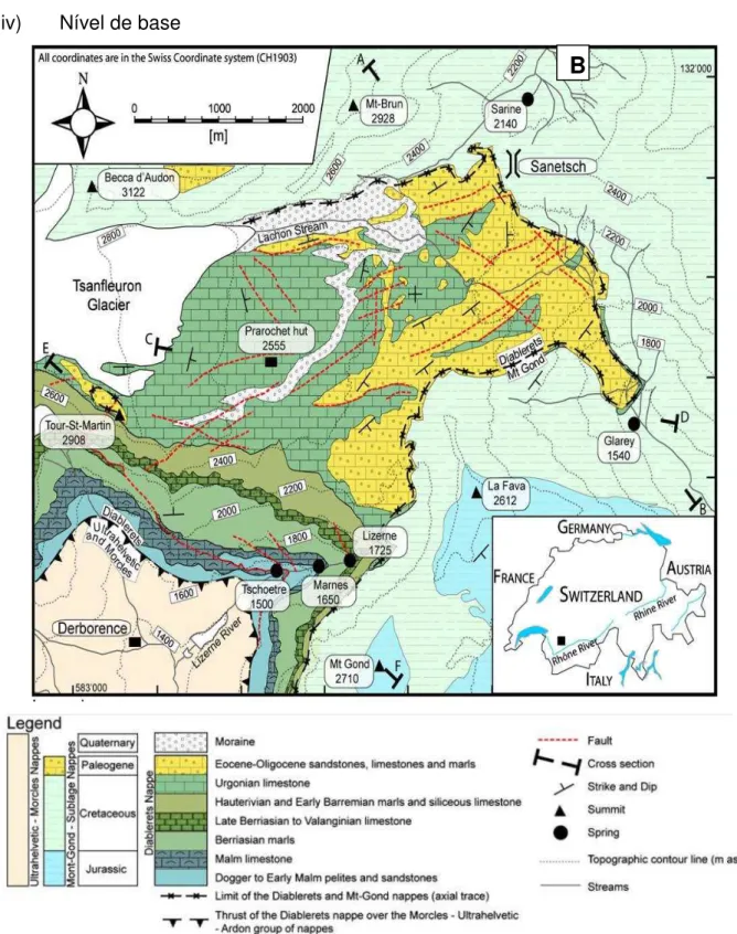
Figura 3.1: Exemplos de mapas estruturais em regiões cársticas, em Tsanfleurum-Sanetsch, Alpes Suíços (Gremaud et al., 2009).
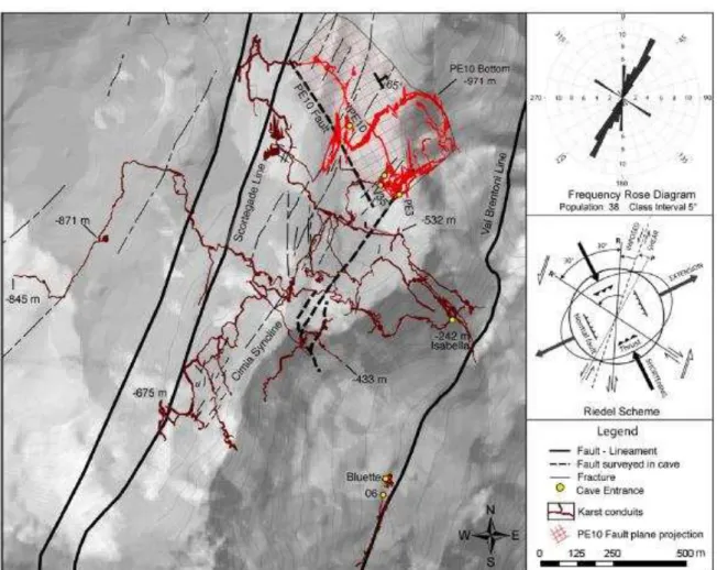
O resultado da análise de feições estruturais e estratigráficas relacionadas a formação do carste pode levar a elaboração de modelos tectônicos para uma determinada área carstificada. Yan et al. (2008) sugeriram o desenvolvimento do carste a partir de juntas em Puding, China, com cavernas e rios ao longo de fratura. Sauro et al. (2013) elaboraram um modelo 3-D para o carste Piani-Eterni, Itália. A Figura 3.2 mostra a área estudada com as estruturas, diagramas de roseta com as direções preferenciais e localização das cavernas. Análises estatísticas da distribuição dos condutos foram feitas a partir de 31 km de condutos visitados. O desenvolvimento da caverna foi devido as feições estruturais e estratigráficas.
Figura 3.2: Vista em planta do carste Piani-Eterni, estruturas em superfície e subsuperfície. Em vermelho, os condutos ao longo da direção PE-10, estrutura tectônica não reconhecida em superfície.
À direita, diagrama de roseta (Sauro et al., 2013).
Gremaud et al. (2009) obtiveram velocidades do fluxo nas dobras em rochas da caverna Mammoth, nos Estados Unidos. Os sinclinais atuaram como caminho preferencial, e sua porção superior tem velocidade máxima linear de 91m/h. Os anticlinais também atuaram como rotas preferenciais. O fluxo na porção superior continua até abaixo do fundo do vale, com velocidade de 22m/h.
4
–
Artigo “Superposed folding and associated fracturing
influence hypogene karst development in Neoproterozoic
carbonates, São Francisco craton, Brazil”
Submetido à revista Tectonophysics
Renata A. Ennes-Silva1, Francisco H.R. Bezerra1*, Francisco C.C. Nogueira2, Fabrizio Balsamo3, Alexander Klimchouk4, Caroline L. Cazarin5, Augusto Auler6
1 – Programa de Pós-Graduação em Geodinâmica e Geofísica, Universidade Federal do Rio Grande do Norte, 59078-970, Natal, RN, Brazil
2 – Unidade Acadêmica de Engenharia Mecânica, Universidade Federal de Campina Grande, Rua: Aprígio Veloso, Nº 812, Campus Universitário, 58429140 - Campina Grande, PB, Brazil
3 – Department of Physics and Earth Sciences, Parma University, Campus Universitario, Parco Area delle Scienze, 157/A, I-43124, Parma, Italy
4 – Institute of Geological Sciences, National Academy of Science of Ukraine, Kiev, Ukraine
5 – Petrobras, Centro de Pesquisa e Desenvolvimento Leopoldo Américo Miguez de Mello (Cenpes), Av. Horácio Macedo, 950, Cidade Universitária Rio de Janeiro, 21941-915, RJ, Brazil
6 – Carste Ciência e Meio Ambiente, Rua Aquiles Lobo 297, Floresta, Belo Horizonte, 30150-160, MG, Brazil
Highlights
We carried out a structural analysis at giant caves in Neoproterozoic
carbonates.
Hypogene cave patterns is influenced by existing pattern of superposed
folding.
Cave passages follow N-S and ENE to E-W-oriented anticlines hinges.
Folding events have regional significance and occurred during the Brasiliano
cycle.
This study enhances our capability to predict cave pattern in layered
Abstract
Porosity and permeability along fractured zones in carbonates could be significantly enhanced by ascending fluid flow, resulting in hypogene karst development. This work presents a detailed structural analysis of the largest cave system in South America to investigate the relationship between karst conduits and regional deformation. Our study area encompasses the Toca da Boa Vista (TBV) and Toca da Barriguda (TBR) caves, which are composed of 107 km and 34 km long, respectively. This cave system occurs in Neoproterozoic carbonates of the Salitre Formation, in the northern part of the São Francisco Craton, northeast of Brazil. The fold belts around and at the craton edges were deformed during the Brasiliano orogeny in a compressive setting at 750-540 Ma. Based on the integrated analysis of fold and brittle deformation in the caves and in outcrops of the surrounding region, we show the following: (1) major cave passages, at the middle storey of the system, considering both length and frequency, developed subhorizontally along (a) N-S and (b) ENE to E-W-oriented anticline hinges; (2) conduits were formed by dissolution of subvertical joints, which present a high concentration along anticline hinges due to folding of competent grainstone layers; (3) the first folding event F1 has been already documented in the region and corresponds to a N-S-trending compression, whereas the second event F2, documented for the first time in the present study, is related to an E-W-compression; (4) both folding events occurred during the Brasiliano orogeny. We conclude that fluid flow and related dissolution pathways have a close relationship with regional deformation events, thus enhancing our capability to predict karst pattern in layered carbonates.
4.1- Introduction
Fracture control of fluid flow has been long recognized as an important process in hydrogeology and ore and petroleum geology (e.g., Long et al., 1996; Faybishenko et al., 2005; Agar and Geiger, 2014). The last two decades have seen an increase in studies of fluid flow related to hypogene karst, which is associated with upward flow in soluble rocks (Klimchouk, 2007, 2009).
Karst features present a close relationship with tectonic structures. Fractures and folds have been identified as important features influencing fluid migration and karst dissolution in carbonates units (White, 1988; Aydin, 2000; Andre and Rajaram, 2005; Klimchouk, 2009; Sauro et al., 2013; Shanov and Kostov, 2015). Recent studies indicate that structurally guided passages of hypogene caves occur in carbonate units in anticlines in Australia (Osborne, 2000, 2001). Both fractures and folds also influence surface karst features in epigenic karst on the outcrop-level in carbonate units (Billi, 2005; Rawnsley et al., 2007). In addition to these field-based studies, numerous numerical models have been used to predict fracture dissolution by fluids in karst settings (Liedl and Sauter, 1998; Kaufmann and Braun, 1999; Dreybrodt et al., 2005).
Despite these advances in the knowledge of the understanding of structural control on karst conduits, several problems are still unresolved. First, a structural analysis of the karst system is lacking in many studies. Second, it is still a matter of debate as to why some tectonic structures are more vulnerable to karst dissolution than other structures. Third, the correlation of fluid dissolution with regional deformation has not been addressed previously. Fourth, in the case of hydrocarbon reservoir studies and despite the use of quantitative assessment and statistical descriptions, detailed and subseismic analysis of the deformation-karstification relationship is still lacking.
the pattern of hypogene caves is influenced by a previously established pattern of superposed folding, and that tectonic and field-bases studies shoul be used in the prediction of fluid pathways and karstification in carbonate units. These results could be used as input data in modeling of reservoirs and aquifers and could enhance our capability to predict the karstification of carbonates by ascending fluids.
Figure 4.1: (A) The South American continent and location of the São Francisco Craton in black; (B) main lithostratigraphic units of the São Francisco Craton and surrounding folding belts (modified from Alkmin et al., 1993). Key: 1, Archean-Proterozoic basement, 2 – Mesoproterozoic sedimentary rocks of the Espinhaço Supergroup, 3 – Neoproterozoic rocks of the São Francisco Supergroup, 4 –
Phanerozoic sedimentary covers, 5 – Neoproterozoic Folding belts, 6 – Structural Lineaments.
4.2 - Geological setting
4.2.1 Tectonic structures and stratigraphy
Pontal belt to the north (Brito Neves et al., 2012), but both the belt and the edge of the craton were deformed during the Brasiliano cycle (Fig. 4.2). In the craton interior, Neoproterozoic units exhibit two phases of deformation. The first includes folds and thrusts that strike NNSSW, and the second includes folds and thrusts that strike E-W, both of which correspond to collisional events that occurred on the margin of the Craton. In the Riacho do Pontal Belt, nappes with four deformation phases (D1, D2, D3, and D4) verge to the South. The D2 event presents lateral ramps that strike N-S, NE-SW, and NW-SE, whereas the D4 event also exhibits strike-slip faults. These events occurred in the late stages of the Brasiliano orogeny (630-575 Ma) (Lagoeiro, 1990; Caxito and Uhlein, 2013).
Figure 4.2: Geological map of the northern part of the São Francisco Craton, including major lithostratigraphic units and tectonic structures (simplified from Bizzi et al., 2003).
Chapada Diamatina Group. This basement encompasses the Tombador, Caboclo and Morro do Chapéu formations (Branner 1910a, 1910b, 1911).
4.2.2 The karst system
The carbonate platforms of São Francisco craton are represented by both Bambuí and Una Groups and contain the most representative karst areas in Brazil, with thousands of known caves (Auler, 1999; Auler and Smart, 2003). The Toca da Boa Vista (TBV) and Toca da Barriguda (TBR) caves are located only 400 m apart, and share many common features. Together, they form the most extensive cave system in South America. They occur at the center of a small carbonate basin that is ~100 km away from the craton boundary to the north (Fig. 4.3). Five lithologic units occur at the eastern part of the TBV-TBR system (Cazarin et al., 2014, 2015). They are as follows, from bottom to top: (1) coarse to medium grainstone (more than 4 m thick), (2) fine grainstone with chert nodules (1-0.5 m thick), (3) microbial carbonate (0.3 – 0.8 m thick), (4) interbedded fine siliciclastics and marls (0.2 – 0.5 m thick), and (5) crystalline grainstone that interfinger with chert layers (more than 5 m thick). The cave system occurs mainly in units 1-4, and the caves are either capped by a siltstone (unit 4) or upper grainstone layer with chert lenses (unit 5) that mark the major cave roofs of passages at the middle story (Cazarin et al. 2014, 2015; Klimchouk et al., 2015). A preliminary description of a superposed folding pattern in the TBV-TBR caves area was presented by Teixeira et al. (2001).
The caves have a hypogene karst origin. Auler and Smart (2003) proposed a shallow hypogene model, where dissolution occurred by sulfuric acid due to dissolution of pyrite occurred by lateral flow. More recently, a deep hypogenic origin of the system by ascending fluids has been proposed and its three-story pattern and functional organization has been demonstrated (Klimchouk et al., 2015). The age of the dissolution was possibly late Brasiliano, which was associated with fluid migrations at the end of the cycle, and the Jurassic-Cretaceous, which is likely related to geodynamic activity during the Pangea breakup (Klimchouk et al., 2015).
4.3 - Methods
This investigation resulted in a detailed structural analysis of the major cave system in South America. We carried out a geological and structural mapping of cave walls and ceilings at both eastern parts of the TBV and TBR caves. In addition, we compared these data with cave map passages and deformation at the regional scale. Despite the fact that no connection has been found between the TBV and TBR caves until the present, the proximity (less than 400 m apart) and genetic unit of these giant caves justifies their joint structural analysis. The Bambuí Group of Speleological Research (Grupo Bambuí de Pesquisas Espeleológicas) has mapped the cave passages since 1986, which resulted in a detailed plan map of the system. We compared the geometry, length and direction of cave passages in the maps with structural data collected inside the caves.
In our study, we consider the cave system to be composed of three main stories, each of which has its own fracture set and lithology (Klimchouk et al., 2015; Cazarin et al., 2014, 2015). This concept involves the role of hydrostratigraphic interfaces caused by poor vertical connectedness of fractures contained in different units (Klimchouk, 2007). The concept of multi-story fracture arrangement as a pre-condition for the development of multi-story hypogene caves was presented by Klimchouk (2003, 2007). Our study focuses on the main cave passages formed in the middle story. The reader is referred to these studies to understand the main morphological features of the karst system.
fold limbs and hinges. We processed the dataset in Openstereo, Stereonet 8, Georient 9.4.5, and TectonicsFP. The structural data are presented in both cicligraphic and polar projection, and rose diagrams. We use the term ‘joint’ when we observed no apparent shear between blocks, fault when we observed movement between blocks, and ‘fracture’ when we could not make the difference. In addition, we used shuttle radar topography and regional maps from Bizzi et al. (2003) to construct geological cross-sections.
4.4 - Results
4.4.1 - General cave features
In this section, we present a detailed structural analysis of cave patterns. Three cave-stratigraphic stories have been identified in the system, largely determined by fracture stratigraphy and vertical connectedness of fractures in different units. Cavities at different stories are distinct in pattern, morphology and function. Cavities at the lower and the upper stories are clustered, having formed along large subvertical fractures, whereas passages at the middle storey (below unit 5) form laterally extensive networks that provided integration of the system (Klimchouk et al., 2015). Some chambers at the lower story can be up 25-30 m wide, but they represent merging of many passages. Passages at the middle story, which are the focus of the analysis by cave maps and the present study, have variable sizes. Larger passages commonly occur at hinges of anticlines. They are called master passages and are normally 3-10 m wide and within 2-4 m high. Where the lower story merges with the upper story, cave passages can have the combined height of 20-25 m. The karst formed in association with fractures along which dissolution occurred.
4.4.2 – Azimuthal analysis of cave passages in map view
direction, and arrangement of cave passages. Then, we constructed rose diagrams based on the direction and length of these passages (Fig. 4.4). The general trend of both TBR and TBV cave system is N45oE. The cave passage trends, however, vary in each domain: domain a (green) exhibits both NNE and E-W-trending passages; domains b (blue) and e (black) exhibits mainly E-W-oriented passages; domains c (yellow) and d (red) exhibit Noriented cave passages and a more scattered, NE-SW to E-W orientation of passages.
Figure 4.4: Map of passages of the TBV and TBR caves and rose diagrams of cave-passage length and orientation. (a), (b), (c), (d) and (e) are structural domains of caves. We simplified cave
maps from the Bambuí Group of Speleological Research.
at the unit 1. These five structural domains, despite their differences, show cave passages along either ~NNE (0o-20o) or ~E-W (70o-100o) trends.
4.4.3– Fold pattern in the caves
We carried out a structural analysis in the eastern sectors of the TBV and TBR caves, as shown in Figure 4.7, which was focused on master passages at the middle story. Usually, these cave passages are subhorizontal with a gentle dip to SW. The maps are mainly based on direct measurements in the caves, analysis of folding pattern and interpretation of remaining geometries of cave maps. All stereoplot diagrams of sedimentary bedding show constant geometry and orientations (Figs. 4.5, 4.6, 4.7 and 4.8). Master passages mainly in the middle story occur along anticline hinges, the strike of which varies from 10° to 50° along NNE-oriented passages and from 80° to 100° along NE-SW to E-W-oriented passages (Fig. 4.7).
Figure 4.5: Map of cave passages and tectonic structures of the cave system (TBV): (A) passage map and (B) structural map of the eastern part of the TBV cave; and (C) stereoplots of sedimentary
Figure 4.6: Map of cave passages and tectonic structures of the cave system (TBR): (D) passage map of and (E) structural map of the eastern part of the TBR cave; (F) are stereoplots of sedimentary
bedding, which are located in (E).
Figure 4.7: Cumulative fold data: (A) cumulative pattern of sedimentary bedding and the superposed fold pattern observed in stereoplot; (C) cumulative data of fold axes. (B) and (D) contour projection of
fold axes.
Gentle limbs with dip angles between 10o to 30o characterize both sets of anticlines (Fig. 4.7). Very few folds, as seen in the stereoplots, are slightly asymmetrical (Figs. 4.5-C-a and 4.6-D-d and f). If viewed collectively, the folds form a dome-and-basin superposed fold pattern, with fold axes of both generations forming an angle from 40° to 70°m (Fig. 4.8). From the combined analysis of cave passages and fold axes, we propose two main phases of folding in the cave area.
Figure 4.8: Cave passages formed along anticline hinges: (A), (C) corresponds to the photo; (B),(D) represent a draft where (1) - (5) are the sedimentary bedding and the sterereoplots are ciclographic
4.4.4 – The joint and fault pattern
Fractures in both TBV and TBR caves includes stylolites, extensional mode I fractures (joints and veins), and conjugate shear fractures. In Units (3) and (4), fractures are mostly concentrated in the fold hinge zone, likely due to folding of competent carbonate strata. The fractures include those inherited from regional deformation and those associated with folding and faulting at the cave scale (m to dm scale). Fractures are usually restricted to single beds, i.e. they are stratabound but also locally cross cut more than one bed.
We observed three main generations of stylolites in the TBV-TBR system, which mainly occur in the grainstone layers of units (1) and (2) and (5). The first generation of stylolites is parallel to the sedimentary bedding and has needles perpendicular to bedding, indicating that they are associated with vertical compression (Fig. 4.9-A, 4.9-B). We named these stylolites as F0 structures. The second generation of stylolites are orthogonal to the first generation, trend E-W and present subhorizontal N-S-trending needles (Fig. 4.9-C and 4.9-D). They are consistent with F1 folds. The third generation is composed of N-S-trending stylolites with E-W trending subhorizontal needles (Fig. 4.9-E and 4.9-F), which are consistent with F2 folds.. There are local mutually cross-cutting relationships between the tectonic stylolites, but the majority of stylolite occurrences indicate the generations above (Fig. 4.9-F), and support the relative chronology of the F1 and F2 events.
Figure 4.9: Main generation of stylolites observed in the TBV-TBR cave system: (A) and (B) are stylolites of the F1 phase; (C) shows stylolites of F2 phase; (D) shows cross-cutting relations of
Figure 4.10: Rose diagram of mode I joints from both caves indicating NW-trending joints associated with F1 folds and E-W-trending joints related to F2 folds.
Figure 4.11: Mode I and conjugate joints in the TBV cave: (A) and (B) ladder pattern of F1 and F2 phase joints along which dissolution occurs. In both cases F1 joints tend N-S and are the longest
fractures. (C) is a photo and (D) drawing of mode I extensional and conjugates joints.
Figure 4.12: Faults zones cutting across folds in the cave passages: (A) is a normal fault NW-SE, (B) is a tension gashes from a normal fault NW-SE, (C) is a fault and damage zone with N-S trending and
(D) is en echelon fault with E-W trending.
4.5 Discussion
The characterization of faults and joints, as well as karstification caused by ascending fluids in carbonate rocks, has been of interest recently (e.g., Agosta et al., 2010). Recent studies have focused of the structural control of karst in carbonate units, such as karst controlled by fractures and folds (Osborne, 2006, 2010; Yan et al., 2008; Koleini et al., 2013). We present an additional case study where the pattern of hypogene karstification is influenced by anticline fold hinges and related fractures.
and TBR shows system of anticlines well, which influenced fluid flow by focusing lateral flow components in the hinges, thus controlling the development of master conduits.
One question that may arise from the identification of dome-basin superposed pattern is the timing between the two folding phases. A few studies have reported that such superposed folding events should be of the order of tens of millions of years (Ramsay and Huber, 1987). This is consistent with the ductile nature of both shortening events, which indicate that the ductile deformation occurred during the Brasiliano orogeny, or more exactly at 630-575 Ma (Caxito and Uhlein, 2013).
We compared deformation in the caves with the regional pattern. The first folding event F1 correspond to folds with E-W to ENE-WSW trending hinges. This fold phase was already described to the north of the study area in the Riacho do Pontal fold belt and it occurred during the Brasiliano orogeny (Teixeira et al., 2001; Brito Neves et al., 2012; Caxito and Uhlein, 2013). The second folding event F2 corresponds to folds with NNE-SSW to E-W trending hinges. The ductile nature of both event indicate that they are related to the Brasiliano orogeny that affected the fold belts to the north and the northern edge of the São Francisco craton.
The first folding phase F1 (N-S- to NNW-SSE trending compression) has already been reported by Brito Neves et al. (2012) and Caxito and Uhlein (2013). Bizzi et al. (2003) included the main deformation of the Salitre Formation in the Brasiliano systems I and II (750-650 Ma). However, Uhlein et al. (2012) described that this phase occurred in the context with folding and metamorphism during the end of Brasiliano cycle at 650-550 Ma. This compressive event was responsible for development of fold belt around the São Francisco craton and had reached interior cratonic areas. At this time, the Una Group (Bebedouro and Salitre formations) was already deposited and was affected by the Riacho do Pontal fold belt. Deformation in the carbonates rocks of Salitre Formation was also studied by Lagoeiro (1990). He concluded that two main events occurred in Chapada Diamantina Group (Morro do Chapéu, Tombador e Caboclo formations) also occurred in Una Group. The second main event (here named F1) masked almost entirely the first one, and it is characterized by intense thrusts, with small angles and south vergency. Locally he also pointed the presence of re-foldings as “domes and basins” pattern.
fold belts to the north of the craton or it could be a local effect such as strike-slip faults. This second phase could arise when the principal stress change during the development, causing two orthogonal compression shortening events or the activity of discrete pulses of short displacement (White and Webb, 2015). The almost orthogonal orientations of joint sets that we observed both in the caves (Fig. 4.10) confirm this interpretation.
Figure 4.13 depicts a model that represents the superposed fold pattern and the main cave passages. The concentration of the main cave passages at the middle story occurs along two generations of fold hinges (Fig. 4.13-A). The meso-scale joint sets, veins, and stylolites observed on cave ceiling and walls are consistent with the F1 and F2 folding phases (Fig. 4.13-B).
Figure 4.13: 3D sketch of superposed fold pattern in the TBV-TBR cave system. (A) corresponds to the units (1) coarse to medium grainstone, (2) fine grainstone with chert nodules, (3) microbial carbonate, (4) interbedded fine siliciclastics and marls, (5) grainstone with chert layers. (B) represents
References
Agar, S.M., Geiger, S. 2014. Fundamental controls on fluid flow in carbonates: current workflows to emerging technologies. Geological Society, Special Publications, London, 406.
Agosta, F., Alessandroni, M., Antonellinni, M., Tondi, E., Giorgioni, M., 2010. From fractures to flow: A field-based quantitative analysis of an outcropping carbonate reservoir. Tectonophysics 490, 197–213.
Alkmin, F.F., Brito Neves, B.B., Castro Alves, J.A., 1993. Arcabouço tectônico do Cráton do São Francisco - Uma revisão. In: Dominguez, J.M.L., Misi, A. (Eds). Sociedade Brasileira de Geologia, Bahia-Sergipe, pp.45–62.
Andre, B.J., Rajaram, H., 2005. Dissolution of limestone fractures by cooling waters: Early development of hypogene karst systems. Water Resources Research, 41, 1-16.
Auler, A.S. 1999. Karst Evolution and Palaeoclimate in Eastern Brazil. Ph.D. Thesis, University of Bristol, 279 pp.
Auler, A. S., Smart, P. L., 2003. The influence of bedrock-derived acidity in the development of surface and underground karst: evidence from the Precambrian carbonates of semi-arid northeastern Brazil. Earth Surface Processes and Landforms 28, 157–168.
Aydin, A., 2000. Fractures, faults, and hydrocarbon entrapment, migration and flow. Marine and Petroleum Geology 17, 797–814.
Bai, T., Maerten, L., Gross, M.R., Aydin, A., 2002. Orthogonal cross joints: do they imply a regional stress rotation? Journal of Structural Geology 24, 77–88.
Belayneh, M., Cosgrove, J.W. 2004. Fracture-pattern variations around amajor fold and their implications regarding fracture prediction using limited data: An example from the Bristol Channel Basin. InThe Initiation,Propagation and Arrest of Joints and Other Fractures, ed. J.W. Cosgrove and T. Engelder. London: Geological Society, Special Publication, 231, 89–102.
Billi, A., 2005. Grain size distribution and thickness of breccia and gouge zones from thin (<1 m) strike-slip fault cores in limestone. Journal of Structural Geology 27, 1823–1837.
Bizzi, L. A., Schobbenhaus, C., Vidotti, R. M., Gonçalves, J.H., 2003. Geologia, Tectônica e Recursos Minerais do Brasil. Texto, Mapas e SIG. CPRM – Serviço Geológico do Brasil, Brasília.
Branner, J. C., 1910a. The Tombador scarpment in the state of Bahia, Brazil. American Journal of Science 30, 335–543.
Branner, J.C., 1911. Aggraded limestone plains of the interior of Bahia and climatic changes suggested by them. Geological Society of America Bulletin 22, 187–206.
Brito Neves, B. B., Fuck, R.A., Martins, M., 2014. The Brasiliano collage in South America: a review. Brazilian Journal of Geology 44, 493–518.
Brito Neves, B.B., Santos, R. A. dos, Campanha, G. A., 2012. A discordância angular e erosiva entre os grupos Chapada Diamantina e Bambuí (Una) na folha Mirangaba-Bahia. Geologia USP, Série Científica 12, 99–114.
Caxito, F. D. A., Uhlein, A., 2013. Arcabouço tectônico e estratigráfico da faixa Riacho do Pontal. Geonomos 21, 19–37.
Cazarin, C.L, Ennes-Silva, R.A., Bezerra, F.H., Borgui, L.F., Auler, A.S., Klimchouk, A. Hypogenic karst dissolution in carbonate rocks has implications for karstified carbonate reservoir. 2015. Article #90216. AAPG Annual Convention and Exhibition, Denver, CO.
Cazarin, C.L., Menezes Santos, C.P., Srivastava, N., Vieira, M.M., Bezerra, F.H., Borgui, L.F. Facies analyses and diagenetic evolution of the hypogene Toca da Boa Vista/Toca da Barriguda cave complex, Salitre Formation (Irecê basin, Brazil) –
Preliminary results in Klimchouk, A., Sasowski, J., Mylroie, J., Engel, S.A., Engel, A.S. Eds., 2014, Hypogene Cave Morphologies. Selected papers and abstracts of the symposium held February, 2014, San Salvador, Island, Bahamas. Karst Waters Institute, Leesburg, Virginia, 111 pp.
Faybishenko, B., Witherspoon, P., Bodvarsson, G., 2005. Emerging issues in fractured-rock flow and transport investigations: introduction and overview, in Dynamics of Fluids and Transport in Fractured Rocks, 162, 1–11, eds Faybishenko, B., Witherspoon, P., Gale, J., American Geophysical Union, Washington, DC, AGU Monograph.
Figueiredo, A.M.F., Braga, J.A.E., Zabalaga, J.C., Oliveira, J.J., Aguiar, G.A., Silva, O.B., Mato, L.F., Daniel, L.M.F., Magnavita, L.P., Bruhn, C.H.L., 1994. Recôncavo Basin, Brazil: a prolific Intracontinental Rift Basin. In: Landon, S.M. Interior Rift Basins (Ed.). American Association of Petroleum Geologists 157–203.
Klimchouk, A.B. 2003. Conceptualisation of speleogenesis in multi-story artesian systems: a model of transverse speleogenesis. Speleogenesis and Evolution of Karst
Aquifers 1 (2), 18 p.
http://www.speleogenesis.info/directory/karstbase/pdf/seka_pdf4475.pdf
Klimchouk, A., 2007. Hypogene Speleogenesis: Hydrogeological and Morphogenetic Perspective. National Cave and Karst Research Institute. Carlsbad, NM, 106 pp.
Klimchouk, A., 2009. Morphogenesis of hypogenic caves. Geomorphology 106, 100–
117.
cave system in Precambrian carbonates, Brazil. Geomorphology (submitted).
Koleini, M., Rooy, J. L. V., Bumby, A., 2013. Hypogenic Karstification and Conduit System Controlling by Tectonic Pattern in Foundation Rocks of the Salman Farsi Dam in South-Western Iran. International Journal of Environmental Earth Science and Engineering 7, 93–100.
Lagoeiro, L.E., 1990. Estudo da deformação nas seqüências carbonáticas do Grupo Una, na região de Irecê, Bahia. MSc Thesis, Universidade Federal de Ouro Preto, Ouro Preto, (105 pp).
Long, J.C.S., Aydin, A., Brown, S.R., Einstein, H.H., Hestir, K., Hsieh, P.A., Myer, L.R., Nolte, K.G., Norton, D.L., Olsson, O.L., Paillet, F.L., Smith, J.L., Thomsen, L., 1996. Rock Fractures and Fluid Flow—Contemporary Understanding and Applications, National Academy Press, Washington, DC, pp. 551.
Misi, A., Veizer, J., 1996. Chemostratigraphy of Neoproterozoic Carbonate Sequences of the Una Group, Irecê Basin, Brazil. In: Anais Congresso Brasileiro de Geologia. Sociedade Brasileira de Geologia, Salvador 5, 487–489.
Osborne, R.A.L., 2000. Palaeokarst and its significance for speleogenesis. In: Klimchouk, A., Ford, D.C., Palmer, A.N., Dreybrodt, W. (Eds.). Speleogenesis: Evolution of Karst Aquifers. National Speleological Society, Huntsville, 113–123.
Osborne, R. A. L., 2001. Karst Geology of Wellington Caves : A review Phases of
Cave Development. Helictite 37, 3–12.
Osborne, R.A.L., 2010. Rethinking eastern Australian caves. In: Bishop, P. and Pillans, B. (Eds.). Australian Landscapes. London: Geological Society of London., pp. 289-308.
Osborne, R., Zwingmann, H., Pogson, R., Colchester, D., 2006. Carboniferous clay deposits from Jenolan Caves, New South Wales: implications for timing of speleogenesis and regional geology. Australian Journal of Earth Sciences, 53, 377-405.
Ramsay, J.G., Huber M. I., 1987. The techniques of modern structural geology. London: Academic Press, 391 pp.
Rawnsley, K., De Keijzer, M., Wei, L., Bettermbourg, S., Asyee, W., Massafero, J.L., Swaby, P., Drysdale, D., Boettcher, D., 2007. Characterizing fracture and matrix heterogeneities in folded Devonian carbonate thrust sheets, Waterton tight gas fields, Western Canada. Geological Society of London Special Publication 270, 265–279.
Sauro, F., Zampieri, D., Filipponi, M., 2013. Development of a deep karst system within a transpressional structure of the Dolomites in north-east Italy. Geomorphology 184, 51–63.
Srivastava, N.K., 1986. Os Estromatólitos do Projeto Bacia de Irecê II. Trabalho de consultoria para CPRM (Serviço Geológico do Brasil), Natal. 9 pp.
Teixeira, C.M., Pereira Filho, M., Cruz, L.V., Lopes, M. V., 2001. Geologia Preliminar
das Grutas : Toca da Boa Vista e Toca da Barriguda , Campo Formoso – Bahia –
Brasil. 26th Brazilian Congress of Speleology, 35–41.
Trindade, R.I.F., D’Agrella-Filho, M., Babinski, M., Brito Neves, B.B., 2004. Paleomagnetism and geochronology of the Bebedouro cap carbonate: Evidence for continental scale Cambrian remagnetization in the São Francisco Craton, Brazil. Precambrian Research 128, 83–103.
Twiss, R. J., Moores, E. M., 1992. Structural Geology. W. H. Freeman and Co., New York, 532 pp.
Uhlein, A., Trompette, R., Egydio-Silva, M., 1992. Rifteamentos superpostos e tectônica de inversão na borda sudeste do cráton São Francisco. Geonomos, 3, 99-107.
White, S., Webb, J., 2015. The influence of tectonics on flank margin cave formation on a passive continental margin: Naracoorte, Southeastern Australia. Geomorphology 229, 58–72.
White, W.B., 1988. Geomorphology and Hydrology of Karst Terrains. Oxford University Press, New York. 464 pp.
White, W.B., 2002. Karst hydrology: Recent developments and open questions. Engineering Geology65, 85–105.
5
–
Discussões e Conclusões
Alguns trabalhos com enfoque no padrão estrutural já foram feitos no sistema TBV-TBR. Auler e Smart (1999) sugeriram desenvolvimento de cavernas por meio de controles estratigráficos e dobramentos suaves. Teixeira et al. (2001) mencionaram a presença de fraturamento paralelo aos eixos de dobras e com direção N-S e ENE-WSW.
A quantificação de direções preferenciais para estruturas e para os condutos do sistema TBV-TBR permitiu a elaboração de diagramas de roseta, projeções ciclográficas e de pólos. A distribuição espacial dos eixos de dobras e a similaridade direcional destes com os azimutes dos condutos indicaram a presença de padrão de interferência de dobras (domos e bacias). Este redobramento é responsável pela geometria e desenvolvimento de condutos cársticos e também estão relacionados com a formação de rotas preferenciais para o fluxo hipogênico. Os mapas estruturais da TBV-TBR representam os sistemas de anticlinais, que influenciaram na circulação de fluxo e controlaram o desenvolvimento de condutos.
A comparação de dados estruturais do sistema TBV-TBR com o padrão regional de deformação indica dois eventos deformacionais. O primeiro F1 corresponde a trend compressional N-S e NNW-SSE (Brito Neves et al. 2012, Caxito e Uhlein, 2013) provavelmente relacionados a eventos do Brasiliano (750-650 Ma) em carbonatos da Formação Salitre. O segundo evento F2, com trend compressional NNE-SSW e E-W, pode estar relacionado aos cinturões móveis ao redor do cráton São Francisco (Faixa Riacho do Pontal) ou pode ser deformação local.
A partir de dados estruturais dos condutos foi possível correlacionar a deformação do sistema cárstico hipogênico TBV-TBR com a tectônica regional relacionada à compressões na margem do cráton São Francisco (Faixa Riacho do Pontal). O sistema se desenvolveu nos eixos de anticlinais que formam padrão de superposição do tipo domos e bacias, com trend N-S (F1) e E-W (F2) e fraturas associadas a carbonatos neoproterozoicos da Formação Salitre. Os condutos das cavernas foram divididos em cinco domínios, com direções preferenciais NNE-SSW e E-W, que correspondem às principais direções para a dissolução hipogênica. As principais estruturas encontradas estão relacionadas com o evento Brasiliano, na margem norte do cráton São Francisco, entre 750-540 Ma.
Referencias
ALKMIN F.F., BRITO NEVES B.B. & CASTRO ALVES J.A., 1993. Arcabouço tectônico do Cráton do São Francisco - Uma revisão. In: J.M.L. Dominguez & A. Misi (eds.) O Cráton do São Francisco, SBG/Núcleo BA/SE/SGM/CNPq, p. 45-62.
ALKMIN F.F., CHEMALE Jr. F., ENDO, I., 1996. A deformação das coberturas proterozóicas do Cráton do São Francisco e o seu significado tectônico. Rev. Escola de Minas, 49, 1, 22-38.
ALMEIDA, F.F.M., 1977 O Cráton do São Francisco. Revista Brasileira de Geociências, 7, 4, 349-364.
AULER, A. S.; SMART, P. L., 2003. The influence of bedrock-derived acidity in the development of surface and underground karst: evidence from the Precambrian carbonates of semi-arid northeastern Brazil. Earth Surface Processes and Landforms, 28, 2, p. 157–168.
AULER, A.S.; SMART, P.L., 1999. Toca da Boa Vista, Bahia state – the longest known cave in the Southern Hemisphere. In: Schobbenhaus, C.; Campos, D.A; Queiroz, E.T.; Winge, M.; Berbert-Born, M. Sítios Geológicos e Paleontológicos do Brasil.
BEZERRA, F.H.R.; TAKEYA, M.K.; SOUSA, M.O.L.; NASCIMENTO, A.F., 2007. Coseismic reactivation of the Samambaia fault, Brazil. Tectonophysics, v. 430, p. 27-39.
BIZZI, L. A.; SCHOBBENHAUS, C.; VIDOTTI, R. M. et al. Geologia, Tectônica e Recursos Minerais do Brasil: texto, mapas e SIG. Brasília: CPRM, 2003. 674 p.
BONFIM, L.F.C.; ROCH, A.J.D.; PEDREIRA, A.J.; MORAIS, J.C., P; GUI-MARES, J.T.; TESCH, N.A. 1985. Projeto Bacia de Irecê. Salvador, CPRM. (Relatório Final).
BRITO NEVES, B.B., SANTOS, R. A. dos, CAMPANHA, G. A., 2012. A discordância angular e erosiva entre os grupos Chapada Diamantina e Bambuí (Una) na folha Mirangaba-Bahia. Geologia USP, Série Científica 12, 99–114.
CAZARIN, C. L. CONTROLE FACIOLÓGICO DO SISTEMA CÁRSTICO HIPOGÊNICO DE CAMPO FORMOSO, BA: Sistema conduto-barreira. (Dissertação de Mestrado) - Rio de Janeiro: UFRJ / IGeo, 2015. 34f.
CAXITO, F. D. A., UHLEIN, A., 2013. Arcabouço tectônico e estratigráfico da faixa Riacho do Pontal. Geonomos 21, 19–37.
DOMINGUEZ, J. M. L., 1993. As Coberturas do Cráton do São Francisco: Uma Abordagem do Ponto de Vista da Análise de Bacia. In: Salvador, Sociedade Brasileira de Geologia, Núcleo (Bahia-Sergipe), p. 173-159.
FORD, D.C., WILLIAMS, P.W., 1989. Karst Geomorphology and Hydrology. Unwin Hyman, London.
FORD D.; WILLIAMS P., 2007. Karst hydrogeology and geomorphology. Wiley. 562 pp.
FORD, D.C.; EWERS, R.O., 1978. The development of limestone caves in the dimensions of length and depth. Canadian Journal of Earth Sciences, 15, 1783-1798.
GUIMARÃES, J.T. 1996. A Formação Bebedouro no Estado da Bahia: Faciologia, Estratigrafia e Ambientes de Sedimentação. Salvador, (Dissertação de Mestrado), 155 f. Instituto de Geociências, UFBA.
GREMAUD, V., GOLDSCHEIDER, N., SAVOY, L., FAVRE, G., MASSON, H., 2009. Geological structure, recharge processes and underground drainage of a glacierised karst aquifer system, Tsanfleuron-Sanetsch, Swiss Alps.- Hydrogeology Journal, 17, 8, 1833–1848.
Grupo Bambuí, 2013. Disponível em: http://www.bambui.org.br/.
KARMANN, I. 1994. Evolução e dinâmica atual do sistema cárstico do alto Vale do rio Ribeira de Iguape, sudeste do estado de São Paulo. (Tese de doutoramento) IGC-USP. 241 pp.
KLIMCHOUK, A., 2007. Hypogene Speleogenesis: Hydrogeological and Morphogenetic Perspective. 106 pp.
KLIMCHOUK, A., 2009. Morphogenesis of hypogenic caves. Geomorphology, 106, 1-2, p.100–117.
KLIMCHOUK, A.; TYMOKHINA, E.; AMELICHEV, G., 2012. Speleogenetic effects of interaction between deeply derived fracture-conduit flow and intrastratal matrix flow in hypogene karst settings. International Journal of Speleology, 41, 161–179.
KOLEINI, M.; ROOY, J. L. VAN; BUMBY, A., 2013. Hypogenic Karstification and Conduit System Controlling by Tectonic Pattern in Foundation Rocks of the Salman Farsi Dam in South-Western Iran. International Journal of Environmental Earth Science and Engineering, 7, 5, p. 93–100.
KRESIC, N., 1995. Remote Sensing of Tectonic Fabric Controlling Groundwater Flow in Dinaric Karst. Remote sensing Environment, 90, 53, p. 85–90.
LAGOEIRO, L.E. 1990. Estudo da deformação nas seqüências carbonáticas do Grupo Una, na região de Irecê, Bahia. Dissertação de Mestrado, Escola de Minas, Universidade Federal de Ouro Preto, 105 p.
MISI, A., SILVA, M.G. Chapada Diamantina Oriental - Bahia: Geologia e Depósitos. Salvador: SGM, 194 p., 1996. (Série de Roteiros Geológicos).
MISI, A.., KAUFMAN; A.J., VEIZER; J., POWIS, K.; AZMY, K.; BOGGIANI, P.; GAUCHER, C.; TEIXEIRA, J.; SANCHES, A.; IYER, S. 2007. Chemostratigraphy correlation of Neoproterozic successions in South America. Chemical Geology 237, 143-167.
MISI, A., VEIZER, J., 1996. Chemostratigraphy of Neoproterozoic Carbonate Sequences of the Una Group, Irecê Basin, Brazil. In: Anais Congresso Brasileiro de Geologia. Sociedade Brasileira de Geologia, Salvador 5, 487–489.
OSBORNE, R. A. L., 2001. Karst Geology of Wellington Caves : a review Phases of
Cave Development. Helictite, 37, 1, p. 3–12.
OSBORNE, R., ZWINGMANN, H., POGSON, R., COLCHESTER, D., 2006. Carboniferous clay deposits from Jenolan Caves, New South Wales: implications for timing of speleogenesis and regional geology. Australian Journal of Earth Sciences, 53, 377-405.
PALMER, A. N., 2011. Distinction between epigenic and hypogenic maze caves. Geomorphology, v. 134, n. 1-2, p. 9–22.
PALMER, A.N., 2003. Speleogenesis in carbonate rocks. Speleogenesis and evolution of karst aquifers, v. 1, n. 1, p.1-11.
PALMER, A.N., 2000a. Hydrogeologic control of cave patterns. In: Klimchouk, A., Ford, D., Palmer, A., Dreybrodt, W. (Eds.), Speleogenesis: Evolution of Karst Aquifers. National. Speleological Society, Huntsville, p. 77–90.
PALMER, A. N., 1991. Origin and morphology of limestone caves. Geological Society of America Bulletin, 103, p. 1–21.
ROMANOV, D.; DREYBRODT, W.; GABROVSEK, F., 2002. Interaction of Fracture and Conduit Flow in the Evolution of Karst Aquifers. Speleogenesis and evolution of karst aquifers, n. 1, p. 2–7.
SAURO, F.; ZAMPIERI, D.; FILIPPONI, M., 2013. Development of a deep karst system within a transpressional structure of the Dolomites in north-east Italy. Geomorphology, v. 184, p. 51–63.
STRINGFIELD, V.T.; RAPP, J.R.; ANDERS, R. B., 1979. Effects of karst and geologic structure on the circulation of water and permeability in carbonate aquifers. Journal of Hydrology, v. 43, p. 313–332.
SRIVASTAVA, N. K. 1986. Os Estromatólitos do Projeto Bacia de Irecê II. Natal:s./s.n./. 9p. Trabalho de consultoria para CPRM. inédito.
Ozarks — Implications for NAWQA and Beyond. USGS scientific investigations report, p. 37–46.
TÎRLĂ, L.; VIJULIE, I., 2013. Structural–tectonic controls and geomorphology of the karst corridors in alpine limestone ridges: Southern Carpathians, Romania. Geomorphology, v. 197, p. 123–136.
TRAN, H., NGO, C., HOANG, Q., NGUYEN, Q., 2011. Structural controls on the occurrence and morphology of karstified assemblages in northeastern Vietnam: a regional perspective. Environmental Earth Sciences, v. 70, n. 2, p. 511–520.
WORTHINGTON, S.R.H., FORD, D.C., 1995. High sulfate concentrations in limestone springs: an important factor in conduit initiation? Environmental Geology 25, 9–15
WHITE, W.B., 1988. Geomorphology and Hydrology of Karst Terrains. Oxford University Press, New York. 464 pp.