A simple qualitative approach for mapping regional landslide
susceptibility in the Faroe Islands
M.-P. J. Dahl1,2, L. E. Mortensen2, A. Veihe1, and N. H. Jensen1
1Department of Environmental, Social and Spatial Change, Roskilde University, Universitetsvej 1, P.O. Box 260, 4000 Roskilde, Denmark
2Jarðfeingi (Faroese Earth and Energy Directorate), Brekkutun 1, 0110 Tórshavn, Faroe Islands
Received: 9 June 2009 – Revised: 6 January 2010 – Accepted: 17 January 2010 – Published: 1 February 2010
Abstract.The Faroe Islands in the North Atlantic Ocean are highly susceptible to landslides. Following recent landslide incidents, Jarðfeingi (Faroese Earth and Energy Directorate) has pointed out, that the risk of human lives or of property being lost or affected by landslides may be increasing. This paper aims at presenting and testing a simple qualitative ap-proach for mapping regional landslide susceptibility in the Faroe Islands, using few key parameters. The susceptibility model holds information about both landslide initiation areas and runout zones. Landslide initiation areas are determined from slope angle thresholds (25◦–40◦) and soil cover data,
while runout zones are delineated using the angle of reach ap-proach taking into account the presence/absence of geolog-ical benches in the runout path, which has not been consid-ered in earlier studies. Data input is obtained from a landslide database containing 67 debris flows throughout the Faroe Is-lands. Angle of reach values differ significantly with the presence/absence of geological benches in the runout path. Two values of angle of reach, 21.5◦and 27.6◦, are used for
calculating runout zones. The landslide susceptibility model is tested in a study area at the town of Klaksvík in the north-ern part of the Faroe Islands. A map validation comparing predicted susceptibility zones with a validation-dataset of 87 actual landslides in the study area reveal that 69% and 92%, respectively, of actual landslide initiation areas and runout zones are correctly predicted. Moreover 87% of the actual landslides are included in the overall predicted landslide sus-ceptibility areas.
Correspondence to:M.-P. J. Dahl
1 Introduction
The Faroe Islands in the North Atlantic Ocean (Fig. 1) are highly susceptible to landslides. The 18 islands, covering an area of 1397 km2, are dominated by high mountains ris-ing from the ocean to a height of app. 900 m above sea level (m a.s.l.). Landslides are mainly rock falls and debris flows as defined by Cruden and Varnes (1996). Particularly the latter are very common (Dahl, 2007), due to steep land-scape, high precipitation (900–3200 mm/yr), (Cappelen and Laursen, 1998), and basaltic parent material overlain by a colluvial soil layer ranging from 0 to 8 m (Dahl, 2007). Dur-ing recent years damagDur-ing landslide events, mainly triggered by extreme rainfalls, have led to increased focus on loss of human lives and property caused by debris flows. Jarðfeingi (Faroese Earth and Energy Directorate) has pointed out, that landslide risk to the population and to human activities may be increasing due to climate change and to the fact that hu-man activities are taking up still larger areas of the Faroese landscape (Mortensen, 2001, 2004). There is hence a grow-ing need for developgrow-ing landslide susceptibility maps which may be used for planning purposes.
Landslide susceptibility is generally seen as expressing the likelihood that a landslide will occur in an area as a function of local terrain conditions (Soeters and Van Westen, 1996). In other words, a landslide susceptibility map points out ar-eas, which are likely to hold landslides in the future (Brabb, 1984). Several authors have emphasized, that mapping slide susceptibility should include both recognition of land-slide initiation areas and an assessment of runout behavior of the landslide material (Dai et al., 2002; Corominas et al., 2003; Hürlimann et al., 2006; Guinau et al., 2007).
mapping or expert evaluation (Malgot and Mahr, 1979; Ives and Messerli, 1981; Rupke et al., 1988; Wachal and Hu-dak, 2000; Morton et al., 2003; Sarkar and Anbalagan, 2008), while quantitative approaches can be divided into mechanistic (Terlien et al., 1995; Wu and Sidle, 1995; Alcantara-Ayala, 2004; Collins and Znidarcic, 2004; Dahl, 2007) and statistical methods (Ayalew and Yamagishi, 2005; Domínguez-Cuesta et al., 2007; Guinau et al., 2007; Magli-ulo et al., 2008). Mapping landslide initiation susceptibility by the use of expert evaluation is the qualitative approach most broadly used (He and Beighley, 2008), and is also the method chosen for this paper. Expert evaluation allows land-slide prone areas to be determined through fieldwork and subsequent analysis, taking into account a variety of geolog-ical, hydrologgeolog-ical, geomorphologic and land use parameters (Rupke et al., 1988; Huabin et al., 2005; Sarkar and Anbal-agan, 2008). Although the subjectivity involved in weighing and rating the parameters as well as the reproducibility of the results constitute disadvantages to the approach (Dai and Lee, 2002; Dai et al., 2002; Huabin et al., 2005), mapping landslide initiation areas by the use of expert evaluation in many cases can be done successfully at any scale (He and Beighley, 2008).
When mapping runout distances of landslides, empiri-cal (Cannon and Savage, 1988; Corominas, 1996; Dai and Lee, 2002; Corominas et al., 2003), analytical (Hutchinson, 1986; Sassa, 1988) or numerical approaches (McDougall and Hungr, 2004; De Blasio et al., 2005; Valentino et al., 2008; Wang et al., 2008) can be used. A simple empirical method which is used in many papers, although it cannot delineate a travel path (Dai et al., 2002), is the angle of reach (AOR) approach. The AOR, which was first introduced by Heim (1932) as the Fahrböschung, is defined as the angle con-necting the crown of a landslide with the distal margin of the runout material. Since introduced by Heim, correlations between AOR and changes in landslide volume, type and runout path have been investigated by many authors (e.g. Scheidegger, 1973; Hsü, 1975; Corominas, 1996; Dai and Lee, 2002; Corominas et al., 2003). However, an aspect of the approach not yet examined is the change in AOR as a con-sequence of a stepwise landscape seen as geological benches in the runout path. In this paper, different AOR values were calculated taking into account the presence/absence of geo-logical benches in the runout path and implemented in the landslide susceptibility model.
Previous works on landslides in the Faroe Islands are very sparse. Jørgensen (1978) described the morphology of 9 mainly rock slides, originating from late or post glacial time, in Suðuroy (the southernmost island of the Faroe Islands), three of which have later been redefined as rock glaciers (Humlum, 1998). In a multidisciplinary study by Lawson et al. (2005) it was found that from 2000–4000 yr BP, a gen-eral slope destabilization in the Faroe Islands occurred, most likely due to climate changes. When analyzing 4 soil pits on a slope at Klaksvík on the island Borðoy Christiansen et
al. (2007) identified app. 10 organic-rich layers which had been buried by debris flow runout material. Of the 10 layers, 7 were dated to between 7940–2060 yr BP (Christiansen et al., 2007). Dahl (2007) conducted a mechanistic landslide susceptibility assessment on a 1:1000 scale using the infi-nite slope model (Ward, 1976; Selby, 1993). The result was highly affected by the large local variations of soil depth and cohesion (Dahl, 2007). Large variations in Faroese soil prop-erties are also found in Hansen (1990), and Veihe and Thers (2007). The large local variation in soil parameters is a major obstacle for potentially assessing regional landslide suscep-tibility in the Faroe Islands using a mechanistic approach.
The purpose of this paper was to test a simple qualitative approach for mapping regional landslide susceptibility in the Faroe Islands, using only few key parameters. The suscepti-bility model contained information about both landslide initi-ation areas, which were determined from slope angle thresh-olds and soil cover data, and runout zones, which were de-lineated using the AOR approach. A novel approach taking into account the presence/absence of geological benches in the runout path, were used for calculating AOR values. The model was tested in a study area at the town of Klaksvík in the northern part of the Faroe Islands by producing a GIS-based landslide susceptibility map. A simple approach for assessing susceptibility was chosen because of its advantage of being easy and fairly inexpensive to carry out and to ex-trapolate to other landslide prone areas in the Faroe Islands, as discussed in Sect. 6.
2 Landslide characteristics
Landslides in the Faroe Islands are mainly rock falls and rainfall-triggered debris flows as defined by Cruden and Varnes (1996). Particularly debris flows are very common and are the only landslides considered in this paper. Hence only these landslides are described in detail in the follow-ing section. Most debris flows are open-sloped, while few are channelized. Landslide initiation is shallow and trans-lational with slide planes either occurring within the soil, at the contact zone between the soil and the underlying rocky parent material, or in combination between the two. Slide planes never occur within the rocky parent material. In most of the landslides, runout material reaches valley bottoms, but do not travel further down the valley. In general, erosion and entrainment along the runout path is negligible.
3 Study area
500 Km
Great Britain
Norway
Denmark
European
mainland
The Faroe Islands
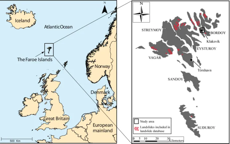
Fig. 1.Location of the Faroe Islands, the study area and landslides included in the landslide database.
Klaksvík is located at sea level surrounded by fjords and steep mountain sides, which rise to app. 650 m a.s.l. As in many other towns and villages of the Faroe Islands, new buildings and infrastructure can be established mainly up-hill on the steep slopes, thus increasing the landslide threat to the population and to human activities. A large num-ber of landslide scars and runout deposits on the mountain sides surrounding Klaksvík and several historic events indi-cate that these slopes are highly susceptible to landslides and snow avalanches. In 1745 and in 1765 large snow avalanches struck the town, the latter killing 19 people (Christiansen et al., 2007). Moreover, in 2000 following heavy rain (200– 300 mm/48 h), a debris flow struck a house and a construc-tion area in the town (Christiansen et al., 2007).
The climate in the Faroe Islands at sea level is temperate oceanic, humid and windy with mild winters and cool sum-mers. Annual precipitation in the study area is 2710 mm, measured at the nearest climate station app. 3 km north of Klaksvík at 6 m a.s.l. (Cappelen and Laursen, 1998). The mean annual air temperature (MAAT) a.s.l. for the Faroe Is-lands is 6.5◦C (Cappelen and Laursen, 1998). However, a
mean annual lapse rate of−0.0077◦C/m (Christiansen and
Mortensen, 2002), results in a MAAT about 1.5◦C at the
highest points within the study area.
The Faroe Islands are remnants of an ancient basalt plateau originating from volcanic activity related to the tertiary open-ing of the NE Atlantic Ocean (Rasmussen and Noe-Nygaard, 1969a). The plateau mainly consists of three tholeiitic basalt formations which are built up of numerous lava flows (Ras-mussen and Noe-Nygaard, 1969a). In the study area, the par-ent material consists of the middle basalt formation (Malin-stindur Formation), and the upper basalt formation (Enni For-mation), respectively (Rasmussen and Noe-Nygaard, 1969b; Passey and Bell, 2007). The upper part of the Malinstindur Formation which make up the parent material from sea level to app. 120 m a.s.l. in the study area (Rasmussen and Noe-Nygaard, 1969b), consists of plagioclase-phyric lava flows with a thickness from<1 to app. 10 m (Rasmussen and Noe-Nygaard, 1969a). The Enni formation, making up the par-ent material in the rest of the study area mainly consists of aphyric, crypto-phyric and olivine-phyric lava flows with a thickness from app. 8 to 11 m (Rasmussen and Noe-Nygaard, 1969a). The two basalt formations in the study area are dip-ping app. 1.4◦towards SE, and interbasaltic tuff-layers with
Water and wind erosion, together with chemical and phys-ical weathering and the quaternary glacial erosion has bro-ken down the original basalt plateau and created the present glaciated Faroese landscape (Humlum, 1996; Christiansen, 1998). The lower parts of the study area are dominated by a concave landscape, cirque valleys and streams in between free face geological benches, which are remnants of the an-cient lava flows. The geological benches (henceforward re-ferred to as basalt benches) and steeper slopes become more dominant with altitude a.s.l. until reaching the top of the an-cient basalt plateau, which is seen as essentially flat mountain tops and upper convexities. Present soil formation began af-ter the Weichselian ice age, and soil depths in the study area vary from 0 to app. 3.5 m. Soil formation in the study area and in the Faroe Islands in general is highly dominated by sedimentological processes (Dahl, 2007; Veihe and Thers, 2007). This is exemplified by organic-rich soil layers buried by landslide runout material (Christiansen et al., 2007; Dahl, 2007) as well as a high gravel and stone content in the soil (Rutherford and Debenham, 1981; Veihe and Thers, 2007; Dahl, 2007) originating from downslope landslide and wa-ter transport processes. Thus the soil can be characwa-terized as colluvial. Analysis from three soil pits in the study area define soil texture as sandy loam and loamy sand according to the USDA (1975) soil texture classification system (Dahl, unpublished), which is in good agreement with results from Dahl (2007) and Veihe and Thers (2007). Grasses and herbs, which is the only vegetation covering the area, is grazed by sheep throughout the year.
4 Methodology
The landslide susceptibility zonation was prepared consider-ing slope angle thresholds, soil cover data (presence/absence of soil on the underlying parent material) and runout zones, determined using the AOR approach. Input data were col-lected from a database containing 67 landslides visited and examined throughout the Faroe Islands. Subsequently, land-slide initiation areas, based on observed critical slope an-gles for landslide initiation, and runout zones were delineated within the study area by the use of GIS (ESRI ArcMap 9.3), creating a landslide susceptibility map. The susceptibil-ity model was validated by comparing it with a validation-dataset showing the spatial occurrence of actual landslides in the study area. Thereby two different landslide datasets and geographical areas were used for constructing and validating the landslide susceptibility model.
4.1 Landslide database
To define the susceptibility zonation and to describe the land-slide characteristics, a database was prepared with the infor-mation collected from 67 debris flows throughout the Faroe Islands. Landslides included in the database were selected
using two criteria: 1) They should have a surface of rupture length>10 m to be considered large enough to cause dam-age to human activities, had they occurred near infrastructure or populated areas. 2) If possible they should be placed in close vicinity to each other, making it possible to visit a large number of landslides in a limited period of time. There were no preferences regarding slope angle, altitude, geology, land use, vegetation, soil depth or slope aspect.
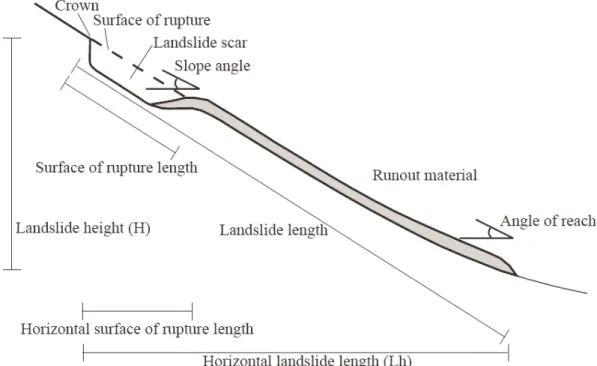
For each of the 67 landslides (Fig. 1) surface of rupture depth, slide plane, slope angle and AOR were determined in the field. The surface of rupture depth was measured accord-ing to the definitions of landslide dimensions in Cruden and Varnes (1996). The slide plane was designated either to be within the soil, at the contact zone between soil and underly-ing rock, or a combination between the two. The slope angle and the AOR were measured using a hand held inclinometer. The two angles were measured from the bottom of the land-slide scar and from the distal margin of the runout zone to the crown of the scar, respectively (Fig. 2).
4.2 The susceptibility model and map
Exploiting digital orthophotos (resolution: 0.5 m) georefer-enced with a digital elevation model (DEM) in a TIN envi-ronment in GIS (ESRI ArcMap 9.3) (the DEM was derived from a 1:20 000 scale topographic map; equidistance: 10 m), it was possible to measure surface of rupture width, horizon-tal surface of rupture length and horizonhorizon-tal landslide length (Lh) (Fig. 2). The two latter, together with observed values of slope angle and AOR, were utilized to compute landslide height (H ), surface of rupture length and landslide length (L)(Cruden and Varnes, 1996). Landslide volumes were es-timated using Eq. (1) (Cruden and Varnes, 1996).
Landslide volume=1
6π DrWrLr (1)
Fig. 2.Landslide dimension terminology used in this paper.
runout path. All AOR values were calculated through linear regression (cf. Sect. 5.2) and simple trigonometry, Eq. (2). AOR=tan−1
H
Lh
(2) A maximum horizontal landslide length (Lh) of 374 m, was used to calculate AOR values, since this was the maxi-mum horizontal landslide distance measured in the landslide database and in the Faroe Islands.
Areas having slope angles between 25◦ and 40◦, which
from data in the landslide database had been recognized as being susceptible to landslide initiation (cf. Sect. 5.1) were delineated within the study area using the DEM. Areas not covered with soil were identified on the orthophotos and ex-cluded from the landslide initiation susceptibility zones as well as susceptibility zones less than 10 m in length.
Runout zones were calculated from average AOR values by substitutingLhwith 374 m in equations of Table 3. At the highest hillslope point and 10 m above the bottom of each defined landslide initiation area as well as for every 100 m along the mountain side a landscape profile down the slope, parallel to the slope angle orientation, was drawn in GIS. At each profile, it was visually estimated from the digital or-thophotos and from the shape of the drawn profile, whether or not any basalt benches were present in the runout path. Figure 3 shows examples of landscape profiles with and with-out basalt benches.
Dependent on whether basalt benches were estimated to be present or absent in each runout path, X and Y coordi-nates for a straight AOR-line starting in the same point as
the drawn landscape profile, and declining with AOR were calculated and visualized together with the drawn landscape profile in GIS. At landscape profiles without basalt benches an average AOR value of 21.5◦was used (cf. Sect. 5.2), and
the runout length was defined to the point where the AOR-line intersected the landscape profile (Fig. 3a). At landscape profiles with basalt benches an average AOR value of 27.6◦
was used (cf. Sect. 5.2), and the runout length was defined to the farthest point where the AOR-line intersected the land-scape profile (Fig. 3b), since runout material was observed to be able to overrun basalt benches in the landscape.
At all landscape profiles, estimated runout lengths were visualized as downslope endpoints in GIS and connected to delineate final runout zones.
4.3 Validation
Fig. 3.Graphs showing landscape profiles (black lines), AOR-lines used in the susceptibility model (red lines) and AOR-line representing “true” dynamic friction coefficient when basalt benches are present in the runout path (blue dashed line). Black dashed lines are showing runout lengths.(A)Landscape profile without basalt benches,(B)Landscape profile with basalt benches.
4.4 Statistical analysis
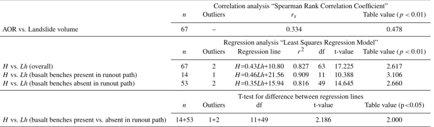
Variations in landslide parameters from the landslide database were described using coefficients of variation (CV). Potential correlations between landslide volume and AOR were tested by use of Spearman Rank Correlation Coeffi-cient. Linear regression between horizontal landslide length (Lh) and landslide height (H )was described using the Least Squares Regression Model, which was tested by use of the coefficient of determination and a t-test. The difference in regression lines of horizontal landslide length (Lh) and land-slide height (H ) with basalt benches present/absent in the runout path was tested using a t-test.
5 Results
5.1 Landslide database characteristics
Examining the 67 landslides throughout the Faroe Islands re-vealed the following characteristics. Mean surface of rupture length and width were 36.7 m and 18.4 m, respectively (Ta-ble 1). Surface of rupture depth varied from 0.2 m to 5.0 m, partly reflecting the variation in soil depth in the Faroe Is-lands, since 60% of the landslides had slide planes occurring entirely or partly along the contact zone between soil and un-derlying rock (Table 1). Surface of rupture lengths, widths, depths and landslide volumes all had high CVs (Table 1), reflecting the large variation of the size and shape of the in-vestigated landslides.
Slope angles for landslide initiation varied from 22◦ to
40◦, with a mean value of 32◦and a CV of 0.12. From
calcu-lated landslide ratios, which varied from 0.5 to 7.9 on land-slide prone slope angles (Table 2), it was decided to set the lower and higher slope angle thresholds for landslide
initi-0 20 40 60 80 100 120 140 160 180 200
0 50 100 150 200 250 300 350 400
L
an
d
sl
id
e
h
ei
g
h
t
(H
),
(m
)
Horizontal landslide length (Lh), (m)
Ba sa ltic benches present in runout pa th Ba sa ltic benches a bsent in runout pa th
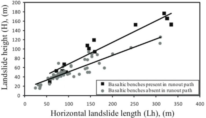
Fig. 4. Correlations between landslide height (H )and horizontal landslide length (Lh) with basalt benches either present or absent in runout path.
ation in the susceptibility map at 25◦ and 40◦, respectively.
Slope angles between 20◦and 25◦were excluded because of
the very low landslide ratio of 0.5. Moreover, Table 2 shows that no landslides occur on slopes<20◦and>40◦. Slopes
which are gentler are considered too flat to provide landslid-ing, while the absence of landslides on very steep slopes is caused by the fact that soil has already slid away in this steep landscape. Furthermore upper slope angles on straight slopes are not much steeper than 40◦; limited by the angle of repose.
5.2 Runout characteristics
AOR values varied from 9.0◦to 42.0◦. The highly significant
(r2=0.827,p <0.01) regression line:H=0.43Lh+10.80 (Ta-ble 3), was used for calculating an overall average AOR of 24.8◦.
Surface of rupture depth (m) 0.2–5.0 1.4 0.64 Landslide volume (m3) 15.9–14 216.4 772.3 2.31 Slide plane type Number of slide planes
Soil 27
Rock contact 17
Soil and rock contact 23
Table 2. Distribution of landslides from the landslide database at different slope angles in the Faroese Islands.
Slope angle Number of % of % of the total Landslide landslides landslides Faroese landscape ratioa
<20◦ 0 0 53.4 0
20–25◦ 3 4.5 9.4 0.5
25–30◦ 8 11.9 8.3 1.4
30–35◦ 27 40.3 7.6 5.3
35–40◦ 29 43.3 5.5 7.9
>40◦ 0 0 15.8 0
a: % of landslides/% of the total Faroese landscape
were present vs. absent in the runout path (Fig. 4) were sig-nificantly different (p <0.05), (Table 3). The two highly sig-nificant regression lines (r2=0.909,p <0.01) and (r2=0.816, p <0.01), (Table 3) were used for calculating AOR when basalt benches were present vs. absent in the runout path. The two AOR values, 27.6◦and 21.5◦, were calculated using
Eq. (2) in order to delineate runout zones in the study area. No significant correlation was found between AOR and land-slide volume (Table 3).
5.3 Landslide susceptibility map
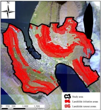
The landslide susceptibility map of the study area is shown in Fig. 5. The map holds information about both landslide initiation areas and runout zones which made up 1.63 km2 (20%) and 3.91 km2(48%) of the study area, respectively.
Landslide susceptible areas were seen to potentially af-fect existing buildings and infrastructure in the outskirts of the town. Non-susceptible areas were typically seen inside Klaksvík, in cirque valleys and on essentially flat mountain plateaus.
5.4 Validation
To evaluate the prediction skill of the susceptibility model, the spatial occurrence of 87 actual landslides in the study
Fig. 5.Landslide susceptibility map of the study area at Klaksvík.
area used as a validation set, were subdivided into initiation areas and runout zones. Of the total 2.1×10⁻²km2 actual
landslide initiation areas, 69% were within the predicted ini-tiation areas (Table 4), 20% were located in predicted runout zones, while 11% were found in areas predicted as non sus-ceptible to landsliding (Table 4).
When comparing predicted and actual landslide runout zones, predicted landslide initiation areas were also predicted as being runout zones. This assumption was made since runout material was observed to be naturally represented in initiation areas as a consequence of deposition which began immediately downslope from landslide scars. 92% of the ac-tual 5.7×10⁻²km2 landslide runout zone areas were found
Table 3.Statistical analysis of runout characteristics.
Correlation analysis “Spearman Rank Correlation Coefficient”
n Outliers rs Table value (p <0.01)
AOR vs. Landslide volume 67 – 0.334 0.478
Regression analysis “Least Squares Regression Model”
n Outliers Regression line r2 df t-value Table value (p <0.01)
Hvs.Lh(overall) 67 2 H=0.43Lh+10.80 0.827 63 17.225 2.617
Hvs.Lh(basalt benches present in runout path) 14 1 H=0.46Lh+21.56 0.909 11 10.388 3.106
Hvs.Lh(basalt benches absent in runout path) 53 2 H=0.35Lh+15.94 0.816 49 14.645 2.660
T-test for difference between regression lines
n Outliers df t-value Table value (p<0.05)
Hvs.Lh(basalt benches present vs. absent in runout path) 14+53 1+2 11+49 2.186 2.000
Table 4.Validation of the landslide susceptibility map by comparing actual and predicted landslide initiation areas and runout zones.
Predicted initiation Predicted runout Predicted non areas zones susceptible areas Actual initiation areas 69% 20% 11% Actual runout zones – 92% 8%
predicted as non susceptible to landsliding (Table 4). Fur-thermore, 76 of the 87 actual landslides were found in the overall predicted landslide susceptibility areas, correspond-ing to an accuracy of 87%.
6 Discussions and conclusions
In this study slope angles for landslide initiation varied from 22◦to 40◦, which is consistent with results from Dahl (2007),
where the lower threshold for landslide initiation was esti-mated to be 25◦. Other studies on landslides which are also
shallow, translational and within a temperate climate regime have also shown consistency with respect to slope angle val-ues. D’Amato Avanzi et al. (2004) recorded slope angles for landslide initiation between 25◦and>45◦with
metamor-phic sandstone and phyllite as parent material. Slope angles up to 45◦was reported by Shakoor and Smithmyer (2005),
with mudrock as parent material, while Matsushi et al. (2006) found slope angles between 32◦and 38◦with mudstone and
sandstone as parent material.
In this study calculated AOR values differed signifi-cantly with the presence/absence of basalt benches in the runout path. Although no earlier studies have examined the influence of geological benches on AOR, obstructions in the runout path have generally been proven to increase AOR. Corominas (1996), plotting log landslide volume for rockfalls, earthflows and translational landslides against log landslide height (H )/horizontal landslide length (Lh),
showed that notably rockfalls and debris flows with volumes <1×10⁴m3 developed higher AOR when obstructing
ele-ments were present in the runout path compared to unob-structed runout paths. Obstructing elements were dense for-est, scree deposits, opposing valley slopes and deflections of the runout material. Higher AOR values in obstructed runout paths were also found in Corominas et al. (2003). Differences in AOR, when investigating rock falls, shallow translational and rotational slides, were in the range of 2– 10◦between obstructed and unobstructed runout paths, with
AOR values varying from 20◦to 54◦. Obstructing elements
This also explains why the runout material can cross the AOR point several times when overrunning basalt benches in the runout path, since tan(AOR) in the presence of basalt benches does not represent the true dynamic friction coeffi-cient of the runout material. The latter theoretical consider-ation has been verified by inserting AOR-lines representing the true dynamic friction coefficient (from AOR=21.5◦)into
all landscape profiles containing basalt benches in the runout path (Fig. 3b). When doing so, topographic profiles were no longer intersected by the AOR-lines.
A large number of studies have investigated the poten-tial negative correlation between landslide volume and AOR. Corominas et al. (2003) found a decrease in AOR of 7◦
with increase in landslide volume from 1 m3to 2×10³m3.
The same tendency was seen in Corominas (1996) in a log-arithmic correlation between tan(AOR) and landslide vol-umes up to 1×10¹⁰m3, and in Dai and Lee (2002), which
used landslide width as an indirect measure of landslide volume. Translational landslides with a width of <20 m and>20 m had AOR of 29.0◦ and 26.7◦, respectively (Dai
and Lee, 2002). However, Scheidegger (1973) and Hsü (1975), comparing landslide volumes with tan(AOR) for a large variety of landslides, indicated that this negative correlation only exists for landslides above 1×10⁵m3 to
0.5×10⁶m3. This argument was supported by Okura et
al. (2003), who found no significant correlation between landslide volume and tan(AOR) for translational landslides between 1×10²to 1.5×10³m3. Thus the non significant
cor-relation between AOR and landslide volume in this paper is believed to be caused by the relatively small landslide vol-umes<1.5×10⁴m3(Table 1).
In this paper 69% of actual landslide initiation areas were correctly located in the predicted susceptibility areas (Ta-ble 4), while 20% were found in predicted runout zones and the remaining 11% were found in areas predicted as non-susceptible. Potential causes for the model inaccuracy are considered later in this discussion. The 69% correctly pre-dicted landslide initiation areas show a good correspondence with another qualitative study, where Ruff and Czurda (2008) found 67% of actual landslide areas to be correctly predicted in high and very high susceptibility areas, using an expert evaluation approach. Compared to these qualitative studies Ayalew et al. (2005) and Duman et al. (2006) found 63% and 80% of actual landslide areas to be correctly predicted in high and very high susceptibility areas using statistical ap-proaches. Moreover, in this paper 87% of actual landslides were found in the overall predicted landslide susceptibility areas, which is consistent with results from other qualita-tive and quantitaqualita-tive studies. In a qualitaqualita-tive study Sarkar
Ayala (2004) found 81% of actual landslides in predicted susceptibility zones using a mechanistic approach. Directly comparing the results from this paper with these other stud-ies is however somehow problematic. The studstud-ies used for comparison have worked with a whole range of susceptibil-ity levels, instead of simply defining an area as being sus-ceptible or non-sussus-ceptible, as is the case in this paper. Nev-ertheless the comparison gives an indication that the simple approach with only a few key parameters tested in this paper performs equally well as several other qualitative and quan-titative landslide susceptibility models applied.
In this paper 92% of actual landslide runout zones were correctly located in the predicted runout zones. Verification data for runout zones comparable to results in this paper is hardly present in the literature. However, as pointed out by Wong and Ho (1996) the AOR approach has proven to give a very realistic assessment of landslide runout distance, as well as calculated runout distances using the AOR approach having proved very consistent with results from numerical approaches (Corominas et al., 2003).
been constructed (cf. Sect. 4.2). Thus local changes in slope angle, which are important for determining landslide initia-tion areas and runout zones as well as for assessing landslide heights and runout lengths, may not be correctly shown by the DEM. 2) Defined slope angle thresholds for landslide ini-tiation areas. Subsequent slope angle measurements in GIS of actual landslide initiation areas in the study area indicated slope angles below 25◦ or above 40◦. Hence, the model
could possibly be improved by including such slope angles when defining landslide initiation areas. 3) Inaccuracies in the calculated AOR values, caused by the difficulty in deter-mining exact horizontal landslide lengths. As a consequence of increasing landslide age, in many cases horizontal land-slide length was difficult to measure, since distal margins of the runout material were no longer recognized as sharp boundaries. 4) The presence of AOR values lower than the 21.5◦and 27.6◦used in the model. Subsequent analysis have
shown that such lower AOR values may account for app. 1% of the 8% observed runout zones found in areas predicted as non-susceptible. Thus, low AOR values only represent a mi-nor problem in the applicability of the susceptibility model. 5) Contribution of several geological, geomorphologic or soil parameters to landsliding, which were not included in this approach. Dahl (2007) indicated that root density can influ-ence the spatial distribution of landslides in the Faroese land-scape. Furthermore, from the literature it is well known, that a large number of parameters such as slope altitude, slope as-pect, vegetation, land use, geology, soil depth, soil cohesion and proximity to drainage lines can affect landslide suscep-tibility. A demand for including more parameters in the sus-ceptibility assessment could lead to another study with the purpose to obtain an improved accuracy of the predicted sus-ceptibility. Including more parameters could either be done through a more comprehensive qualitative expert evaluation or through a quantitative statistical approach. The argument for not using a mechanistic approach is that large local varia-tions in soil properties, which are found in the Faroe Islands Hansen (1990), Dahl (2007) and Veihe and Thers (2007) are problematic in such methods, which imply the ground con-ditions in a chosen study area to be fairly uniform (Dai and Lee, 2002; Dai et al., 2002).
Unlike what is seen in many other landslide susceptibility studies, the current approach does not divide the landscape into differentiated susceptibility classes, but simply classify the study area as being susceptible or non susceptible to land-sliding. This simple zonation terminology may be insuffi-cient in some communities where infrastructure and urban expansion is very intense and where areas moderately sus-ceptible to landsliding therefore need to be utilized for build-ings or infrastructure. However, in the Faroe Islands and other societies where human expansion problems are less in-tense although still important, the simple zonation terminol-ogy can be a sufficient tool for planning purposes. Further-more, this paper sets an example of, how it is possible to effectively map landslide susceptibility using a simple
ap-proach with few parameters, which requires only little work and small economic resources. Hence it could be relevant to test this approach for mapping landslide susceptibility in parts of the World, where funds for scientific research is limited. Finally the approach for mapping landslide runout zones, where AOR is dependent on the presence/absence of basalt benches in the runout path could be adopted when mapping landslide susceptibility in similar landscapes, where basalt benches are dominant.
Acknowledgements. This paper has been carried out in cooperation between Department of Environmental, Social and Spatial Change, Roskilde University, Denmark and Jarðfeingi (Faroese Earth and Energy Directorate), the Faroe Islands. The authors wish to thank Dr Esbern Holmes for technical GIS assistance and Ritta Bitsch for graphical preparations.
Edited by: T. Glade
Reviewed by: J. Corominas and another anonymous referee
References
Alcantara-Ayala, I.: Hazard assessment of rainfall-induced lands-liding in Mexico, Geomorphology, 61, 19–40, 2004.
Ayalew, L. and Yamagishi, H.: The application of GIS-based logis-tic regression for landslide susceptibility mapping in the Kakuda-Yahiko Mountains, Central Japan, Geomorphology, 65, 15–31, 2005.
Ayalew, L., Yamagishi, H., Marui, H., and Kanno, T.: Landslides in Sado Island of Japan: Part II. GIS-based susceptibility mapping with comparisons of results from two methods and verifications, Eng. Geol., 81, 432–445, 2005.
Brabb, E. E.: Innovative approaches to landslide hazard and risk mapping, in: Proceedings of the 4th International Symposium on Landslides, Toronto, Canada, 16–21 September 1984, 307–324, 1984.
Cannon, S. H. and Savage, W. Z.: A mass change model for debris flow, J. Geol., 96, 221–227, 1988.
Cappelen, J. and Laursen, E. V.: The Climate of the Faroe Islands – with Climatological Standard Normals, 1961-1990, Danish Me-teorological Institute, Ministry of Transport, Denmark, Technical report 98-14, 1998.
Christiansen, H. H.: Highland Aeolian Deposits in the Faroe Is-lands, Fróðskaparrit, 46, 205–213, 1998.
Christiansen, H. H., Blikra, L. H., and Mortensen, L. E.: Holocene slope processes and landforms in the northern Faroe Islands, Earth Env. Sci. T. R. So., 98, 1–13, 2007.
Christiansen, H. H. and Mortensen, L. E.: Arctic Mountain Me-teorology at the Sornfelli Mountain in Year 2000 in the Faroe Islands, Fróðskaparrit, 50, 93–110, 2002.
Collins, B. D. and Znidarcic, D.: Stability Analysis of Rainfall In-duced Landslides, J. Geotech. Geoenviron., 130, 362–372, 2004. Corominas, J.: The angle of reach as a mobility index for small and
large landslides, Can. Geotech. J., 33, 260–271, 1996.
Triggering Parameters, M.Sc. Thesis, Roskilde University, Den-mark, 2007 (in Danish with English Abstr.).
Dai, F. C. and Lee, C. F.: Landslide characteristics and slope insta-bility modeling using GIS, Lantau Island, Hong Kong, Geomor-phology, 42, 213–228, 2002.
Dai, F. C., Lee, C. F., and Ngai, Y. Y.: Landslide risk assessment and management: an overview, Eng. Geol., 64, 65–87, 2002. D’Amato Avanzi, G., Giannecchini, R., and Puccinelli, A.: The
in-fluence of the geological and geomorphological settings on shal-low landslides. An example in a temperate climate environment: the June 19, 1996 event in northwestern Tuscany (Italy), Eng. Geol., 73, 215–228, 2004.
De Blasio, F. V., Elverhøi, A., Issler, D., Harbitz, C. B., Bryn, P., and Lien, R.: On the dynamics of subaqueous clay rich gravity mass flows – the giant Storegga slide, Norway, Mar. Petrol. Geol., 22, 179–186, 2005.
Domínguez-Cuesta, M. J., Jiménez-Sánchez, M., and Berrezueta, E.: Landslides in the Central Coalfield (Cantabrian Mountains, NW Spain): Geomorphological features, conditioning factors and methodological implications in susceptibility assessment, Geomorphology, 89, 358–369, 2007.
Duman, T. Y., Can, T., Gokceoglu, C., Nefeslioglu, H. A., and Son-mez, H.: Application of logistic regression for landslide suscepti-bility zoning of Cekmece Area, Istanbul, Turkey, Environ. Geol., 51, 241–256, 2006.
Guinau, M., Vilajosana, I., and Vilaplana, J. M.: GIS-based debris flow source and runout susceptibility assessment from DEM data – a case study in NW Nicaragua, Nat. Hazards Earth Syst. Sci., 7, 703–716, 2007,
http://www.nat-hazards-earth-syst-sci.net/7/703/2007/.
Hansen, L. E.: Soil Development in the Leynavatn Area, M.Sc. The-sis, University of Copenhagen, Denmark, 1990 (in Danish). He, Y. and Beighley, E.: GIS-based regional landslide susceptibility
mapping: a case study in southern California. Earth Surf. Proc. Land., 33, 380–393, 2008.
Heim, A. (Ed.): Bergsturz and Menschenleben, Fretz & Wasmuth Verlag A.G., Zürich, 1932.
Hsü, K. J.: Catastrophic Debris Streams (Sturzstroms) Generated by Rockfalls, Geol. Soc. Am. Bull., 86, 129–140, 1975. Huabin, W., Gangjun, L., Weiya, X., and Gonghui, W.: GIS-based
landslide hazard assessment: an overview, Prog. Phys. Geog., 29, 548–567, 2005.
Humlum, O.: Main Shapes of the Landscape Funningur, Slæt-taratindur, in: Topographic Atlas the Faroe Islands, edited by: Guttesen, R., Royal Danish Geographical Society, Copenhagen, Denmark, 38–41, 1996 (in Danish).
Humlum, O.: Rock glaciers on the Faeroe Islands, the North At-lantic, J. Quaternary Sci., 13(4), 293–307, 1998.
Hutchinson, J. N.: A sliding-consolidation model for flow slides, Can. Geotech. J., 23, 115–126, 1986.
Hürlimann, M., Copons, R., and Altimir, J.: Detailed debris flow hazard assessment in Andorra: A multidisciplinary approach, Geomorphology, 78, 359–372, 2006.
Lawson, I. T., Church, M. J., McGovern, T. H., Arge, S. V., Woo-let, J., Edwards, K. J., Gathorne-Hardy, F. J., Dugmore, A. J., Cook, G., Mairs, K.-A., Thomson, A. M., and Sveinbjarnardót-tir, G.: Historical Ecology on Sandoy, Faroe Islands: Palaeoen-vironmental and Archaeological Perspectives, Hum. Ecol., 33, 651–684, 2005.
Magliulo, P., Di Lisio, A., Russo, F., and Zelano, A.: Geomorphol-ogy and landslide susceptibility assessment using GIS and bi-variate statistics: a case study in southern Italy, Nat. Hazards, 47, 411–435, 2008.
Malgot, J. and Mahr, T.: Engineering geological mapping of the west Carpathian landslide areas, Bulletin of the International As-sociation of Engineering Geology, 19, 116–121, 1979.
Matsushi, Y., Hattanji, T., and Matsukura, Y.: Mechanisms of shal-low landslides on soil-mantled hillslopes with permeable and im-permeable bedrocks in the Boso Peninsula, Japan, Geomorphol-ogy, 76, 92–108, 2006.
McDougall, S. and Hungr, O.: A model for the analysis of rapid landslide motion across three-dimensional terrain, Can. Geotech. J., 41, 1084–1097, 2004.
Mortensen, L. E.: Landslides and weather conditions, Frøði, 1, 18– 22, (in Faroese), 2001.
Mortensen, L. E.: The risk of landslides may be increasing, Sosialurin, 1/5, 2004 (in Faroese).
Morton, D. M., Alvarez, R. M., and Campbell, R. H.: Preliminary soil-slip susceptibility maps, southwestern California, US Geo-logical Survey, USA, Open File Rep. 03-17, 2003.
Okura, Y., Kitahara, H., Kawanami, A., and Kurokawa, U.: Topog-raphy and volume effects on travel distance of surface failure, Eng. Geol., 67, 243–254, 2003.
Passey, S. R. and Bell, B. R.: Morphologies and emplacement mechanisms of the lava flows of the Faroe Islands Basalt Group, Faroe Islands, NE Atlantic Ocean, B. Volcanol., 70, 139–156, 2007.
Rasmussen, J. and Noe-Nygaard, A.: Description to Geological Map of the Faroe Islands, 1st series, 24, Geological Survey of Denmark, Copenhagen, Denmark, 1969a (in Danish).
Rasmussen, J. and Noe-Nygaard, A.: Geological Map of the Faroe Islands, 1st series, 24, Geological Survey of Denmark, Copen-hagen, Denmark, 1969b (in Danish).
Ruff, M. and Czurda, K.: Landslide susceptibility analysis with a heuristic approach in the Eastern Alps (Vorarlberg, Austria), Ge-omorphology, 94, 314–324, 2008.
Rupke, J., Cammeraat, E., Seijmonsbergen, A. C., and Van Westen, C. J.: Engineering geomorphology of the Widentobel catchment, Appenzell and Sankt Gallen, Switzerland. A geomorphological inventory system applied to geotechnical appraisal of slope sta-bility, Eng. Geol., 26, 33–68, 1988.
Rutherford, G. K. and Debenham, P. L.: The mineralogy of some silt and clay fractions from soils on the Faeroe Islands, Soil Sci., 132, 288–299, 1981.
5, 232–240, 2008.
Sassa, K.: Special lecture: Geotechnical model for the motion of landslides, in: Proceedings of the 5th International Symposium on Landslides, Lausanne, Switzerland, 10–15 July 1988, 37–55, 1988.
Scheidegger, A. E.: On the Prediction of the Reach and Velocity of Catastrophic Landslides, Rock Mech., 5, 231–236, 1973. Selby, M. J. (Ed.): Hillslope Materials and Processes, 2nd ed.,
Ox-ford University Press, OxOx-ford, UK, 1993.
Shakoor, A. and Smithmyer, A. J.: An analysis of storm-induced landslides in colluvial soils overlying mudrock sequences, south-eastern Ohio, USA, Eng. Geol., 78, 257–274, 2005.
Soeters, R. and Van Westen, C. J.: Slope instability recognition, analysis, and zonation, in: Landslides investigation and mitiga-tion, edited by: Turner, A. K. and Shuster, R. L., Transportation Research Board, Special Report 247, National Academy Press, Washington D.C., USA, 129–177, 1996.
Terlien, M. T. J., Van Westen, C. J., and Van Asch, T. W. J.: De-terministic modeling in GIS-based landslide hazard assessment, in: Geographical Information Systems in Assessing Natural Haz-ards, edited by: Carrara, A. and Guzzetti, F., Kluwer Academic Publishers, Dordrecht, The Netherlands, 57–77, 1995.
USDA.: Soil Taxonomy, A Basic System of Soil Classification for Making and Interpreting Soil Surveys, Agriculture Handbook No. 436, Washington D.C., USA, 1975.
Valentino, R., Barla, G., and Montrasio, L.: Experimental Analy-sis and Micromechanical Modelling of Dry Granular Flow and Impacts in Laboratory Flume Tests, Rock Mech. Rock Eng., 41, 153–177, 2008.
Veihe, A. and Thers, M.: Pedogenesis and root development in a complex geomorphologic setting in the Faroe Islands, Commun. Soil Sci. Plan., 38, 293–314, 2007.
Wachal, D. J. and Hudak, P. F.: Mapping landslide susceptibility in Travis County, Texas, USA, GeoJournal, 51, 245–253, 2000. Wang, C., Li, S., and Esaki, T.: GIS-based two-dimensional
nu-merical simulation of rainfall-induced debris flow, Nat. Hazards Earth Syst. Sci., 8, 47–58, 2008,
http://www.nat-hazards-earth-syst-sci.net/8/47/2008/.
Ward, T. J.: Factor of Safety approach to landslide potential delin-eation, In partial fulfillment of the requirements for the Degree of Doctor of Philosophy, Colorado State University, Fort Collins, Colorado, USA, 1976.
Wong, H. N. and Ho, K. K. S.: Travel distances of landslide debris, in: Proceedings of the 7th International Symposium on Land-slides, Trondheim, Norway, 17–21 June 1996, 417–422, 1996. Wu, W. and Sidle, R. C.: A distributed slope stability model for