THE DYNAMICS OF CLOPOTIVA VILLAGE
A CARTOGRAPHICAL ANALYSIS
Theodor CEPRAGA
Contents:
1. INTRODUCTION ... 63
2. METHODOLOGY ... 64
3. PRE-MAPS DATA ... 65
4. CARTOGRAPHICAL EVIDENCES ... 67
5. CONFIRMATION THROUGH LOCAL PARTICULARITIES AND TOPONYMY ... 69
6. RESULTS AND CONCLUSIONS ... 72
7. ACKNOWLEDGEMENTS ... 73
8. REFERENCES ... 73
Cite this document:
Cepraga, T., 2014. The Dynamics of Clopotiva Village. A Cartographical Analysis. Cinq Continents 4 (9): 61-73
Volume 4 / Numéro 9
Été 2014 ISSN: 2247 - 2290
p. 61-73
[62]
The Dynamics of Clopotiva Village. A Cartographical Analysis
Theodor Cepraga
Dinamica satului Clopotiva. O analiză cartografică.Studiul își propune să
analizeze dinamica spațială a satului Clopotiva din Țara (ațegului începând cu data atestării documentare și până în prezent. Analiza evidențiază rolul factorilor naturali, istorici și culturali precum și procesele ce stau la baza dinamicii spațiale a acestei așezări. Pentru perioada medievală au fost utilizate informații extrase din monografii, documente istorice și alte studii de specialitate, iar începând cu secolul XV))), pe baza hărților disponibile s -au folosit tehnici G)S pentru a determina modificările morfologice ale satului. Rezultatele au arătat faptul că satul a apărut inițial la sud-vest de poziția actuală, evoluând apoi către Râul Mare și terenurile agricole. Studiul își propune de asemenea să realizeze un model de analiză a dinamicii spațiale a
așezărilor umane din Țara (ațegului.
Cuvinte cheie: Clopotiva, Țara (ațegului, dinamică spațială, toponimie,
cartografie.
The Dynamics of Clopotiva Village. A Cartographical Analysis. The study aims to analyse the dynamics of Clopotiva, a village in (ațeg Country, from the date of its first documentary mention until present. The analysis points out the role of the natural, historical and cultural conditions together with the processes influencing the dynamics of this settlement. Information extracted from monographies, historical documents and other specialised studies were used for the medieval period, and starting with the 18th
century, GIS analysis was applied to the available cartographical documents in order to highlight the morphological transformations of the village. The results showed that the village appeared initially south-west of the actual location, developing towards Râul Mare and the agricultural fields. The study also aims to create an analysis model for the dynamics of the settlements in the (ațeg Country.
1. INTRODUCTION
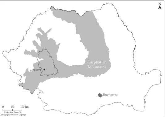
Clopotiva is located in the south-west part of the (ațeg Basin, on the right side of Râul Mare, right at the point where the river makes his way out of the Retezat Mountains. The (ațeg Country, especially Clopotiva, has always represented a key point in understanding the social processes and transformations undergone by the Romanian people in Transylvania. Considering the Hungarian, Turkish, Austrian and Austro-Hungarian rule which totalled almost 900 years in Transylvania, together with a social mix of people including Saxons and Székelys [ ], Clopotiva kept a somehow untainted Romanian way of life. This distinguished character for an intra-Carpathian settlement attracted geographers, historians and sociologists who studied the village with different purposes.
Figure 1. Location of Clopotiva in Hunedoara County
Ovid Densușianu with a study regarding the particularities of the language [2] and Romulus Vuia (1926) with an ethnographic examination [3] could be considered the first researchers in the (ațeg Country. )on Conea is the first one who put Clopotiva on the map of the Romanian academic research, when he completed his sizable study Clopotiva: un sat din Hațeg [ ]. Even though he was a geographer, the purpose of the study was a sociological one and so was the approach. This becomes clear considering that Dimitrie Gusti, the reputed Romanian sociologist, was the head of the initiative. Having a starting point, anthropologists continued the research in Clopotiva and in 1 , ascribed to Ștefan Marius Milcu and (oria Dumitrescu, appeared Cercetări
[64]
Adrian Rusu completed studies on the (ațeg Country in the Middle Ages [ ] and the history of the church, respectively [7]. Nicolae Popa (1999, 2000) wrote about human and economic geography of the (ațeg Country, highlighting subjects like toponymy, development and tourism in the area [8-9]. The present study provides information about the dynamics of Clopotiva considering the natural conditions, the evidences provided by the historical documents and the cartographical representations of Transylvania.
2. METHODOLOGY
The information with regard to the historical events and the environment was processed in order to highlight the dynamics of the village in time. The already existing information on toponyms was confronted and updated through field work in the village. Between the 1st and the 3rd of May 2014, the already known information regarding
natural conditions, toponymy and parts of the village were updated throw direct observation and discussions with the locals. The cartographical documents used in the research were the Josephinische Landesaufnahme (1769-1773) and the Specialkarte
Table 1. Shapefiles used to map the dynamics of Clopotiva
3. PRE-MAPS DATA 3.1 Natural conditions
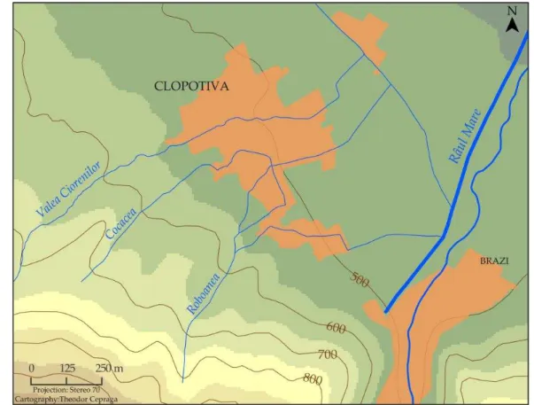
Even though the subject of the research belongs to the field of human geography, we should not elude the physical conditions which have influenced the evolution of the settlement. As the Romanian geographer )on Conea says, the village is located in the mouth of the biggest river which makes its way into the (ațeg Country from the Retezat Mountains; [ ] namely Râul Mare. As the map clearly shows, Figure the level curve which marks 500 meters of altitude comes through the middle of the built-up area of Clopotiva. Practically, the village stands right at the foot of the mountain, where the slope lowers its gradient. Clopotiva also stands between forest and the arable land having access to both of them in almost no time. The most important natural aspect which we consider to have had the biggest influence on the growth of the village is the stream network which flows from the eastern side of the village towards Râul Mare. Other streams were added to the natural network by the inhabitants, but the map shows only the natural flows. According to various historians and archaeologists, including Gooss and Ackner, the water resources attracted romans from Sarmizegetusa who erected an aqueduct to transport the water to the newly built city [4]. Unfortunately the evidence from the Roman period is parsimonious, the research being conducted only through remains of buildings, mortuary monuments and other inscriptions.
Shapefile Type Source Projection
churches point 2005 satelitary image Stereo 70
gates (vranițe) point field work Stereo 70
parts of Clopotiva point field work Stereo 70
level curves polyline (ațeg Country Dinosaur Geopark Stereo 70 national and county roads polyline (ațeg Country Dinosaur Geopark Stereo 70
rivers polyline (ațeg Country Dinosaur Geopark Stereo 70
streams polyline field work and 2005 satelitary
image
Stereo 70
forest polygon (ațeg Country Dinosaur Geopark Stereo 70
1884 built-up area polygon Specialkarte Stereo 70
1769-1773 built-up area polygon Josephinische Landesaufnahme Stereo 70 2014 built-up areas polygon National Agency for Cadastre and
Land Registrastion
[66]
Figure 2. Natural conditions in which Clopotiva developed
3.2 Historical documents
The first evidence from the Middle Ages with respect to Clopotiva is a document from 1360 where the priest Zampa and a peasant Baya, the son of Buz of Clopotiva (Baya
filius Buz de Clapatiua) [10] are mentioned. The document mentions them as members
in the chair of judgement of the (ațeg district in which, at that time, figured knezes, peasants and 5 priests. As of the 15th century, the number of documents in which
Clopotiva is mentioned increased, thus appearing as reference to some local noblemen such Bakocz and Pogány [ ]. Originally, Romanians like Băcuț and Pogan adopted the Hungarian name to satisfy the Hungarian king expectations. These appear to be the strongest families which controlled the entire village and parts from others [11].
Although Clopotiva was never part of a valley knezat it maintained its influence in the region through its nobility [6]. The noble families of Clopotiva are always mentioned in historical documents like homo noster (men of the king) or commetaneus (neighbours) [4]. Considering the more powerful families like Kendeffy originally Cândea or the Densuș noble family who ruled the valley knezates North and West of Clopotiva, the appellative used in the historical documents for the nobles clarifies their status in the (ațeg Country. Another key aspect revealed in the 17th century is the division of the
nowadays we can still talk about a unitary settlement which has parts of it denominated individually.
3.3 The Fight for the Church
This quote belongs to Ion Conea who gave this name to the conflict that occurred in the 18th century when the Orthodox Christians had a quarrel with the Calvinists
Protestants. )f the Catholic Church had not manifested its influence in the (ațeg Country, the Protestant Church, through the noble families who adopted the Calvinist reform, would have transformed the ordinary life of the village [7]. The Protestants used the same church as the Orthodox and had their religious service only after the Orthodox finished theirs, usually turning the religious icons on the blank side. In time, the Protestants started to hurry up the Orthodox to finish their service, causing a deep upset for the peasants. The conflict broke out in on the occasion of the bishop’s visit in Clopotiva. The Orthodox rose to fight the Protestants, encouraged by the bishop’s indignation, but with no success. After a decade of fights and grief, the local noble man, Ioan Pogány, offered in a part from his lands in the built-up area of Clopotiva to the Orthodox, to build a new church in order to end up the conflict [12]. The area is clearly depicted on the first smaller scale map of Transylvania, the Josephinische
Landesaufnahme, which was designed during that period (Figure 3).
4. CARTOGRAPHICAL EVIDENCES
The first relevant cartographical document, the Josephinische Landesaufnahme,
[68]
The Specialkarte is the second cartographical evidence taken into consideration.
It was realised in 1884 at the scale 1:75000 (Figure 4). It is clearly noticeable that the village extended to the east towards the arable lands at the expanse of the western side of Clopotiva which started to disappear. The space where the semi-circular street mentioned above used to be is completely transformed together with many households which were relocated in the eastern side. Also, the southern part of the village known as
Săcel (Szaczál-Klopotiva) started to develop away from the slope of the mountain,
towards the east (Figure 5).
Figure 3. Clopotiva in the Josephinische Landesaufnahme (1769-1773) Figure 4. Clopotiva in the
Specialkarte (1884)
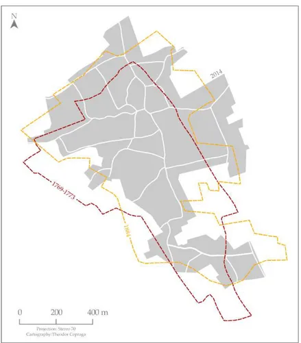
The cartographical analysis is concluded with the comparison between the built-up areas from the previous centuries and the one from the present. The village continued to extend towards east due to the new county road which emerged in the 20th
Figure 5. Evolution of the built-up area of Clopotiva
[70]
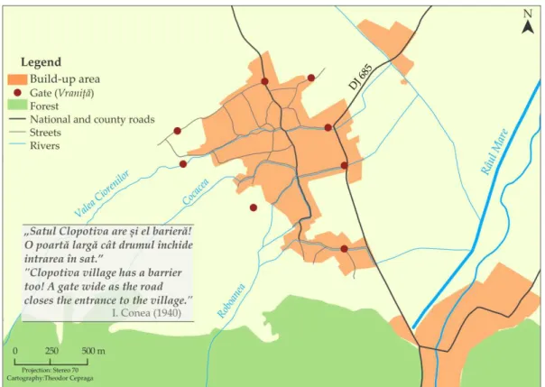
Figure 6. The position of gates (vranițe)
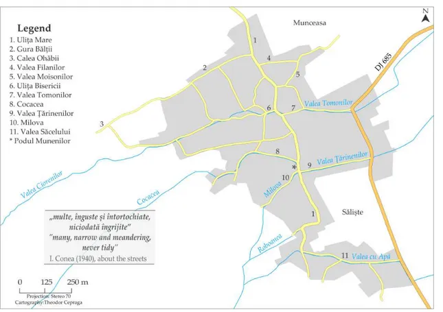
The toponymy plays a crucial role in understanding the transformations of Clopotiva through different periods of time. Ion Conea (1940) has identified 37 odonyms [4] but unfortunately, due to what we consider to be a typography error, only 31 of them have been printed but none of them with its correct position within the village. Today, through field work and talks with the locals a number of 11 odonyms were put on the map (Figure 7). This shows that more than 70 % of the odonyms have disappeared in 70 years. As the map shows (Figure 7), in the west side of the main old road, only hydronyms which passed into odonymy have survived until today together with three important landmarks: Ulița Bisericii (meaning Church Street), Calea Ohăbii (way outside of the village now, marking the road to the closest village and Gura Bălți meaning the mouth of the bog) [16]. This comes to confirm the dynamics of the village from west to east, from the woods towards the new road and to a greater accessibility to arable land, already stated above. Almost all the streets that connect the old main road with the newly built road in the east side of Clopotiva have a name, three of them being anthroponyms, one denominating an occupation of the peasants or a land possession
(Valea Țărinenilor) and one took its denomination from the name of that part of the
Figure 7. The current toponymy of Clopotiva
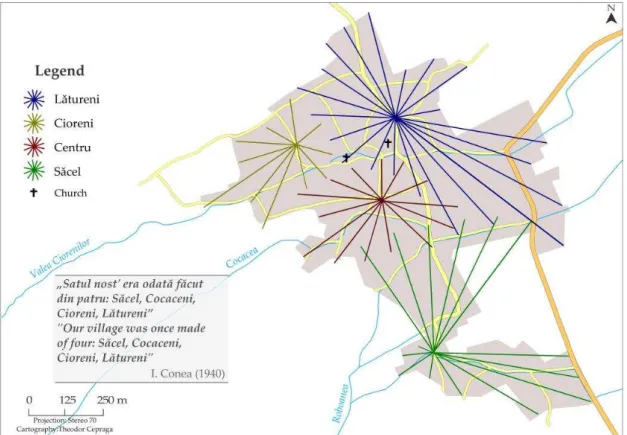
Ion Conea (1940) mentioned that the village was divided into four parts Lătureni, Cioreni, Cocacea and Săcel [ ]. Săcel, meaning small village in the Romanian toponymy is surely the same part of the village mentioned in the historical documents as
Szaczál-Klopotiva with Cioreni, Cocacea and Lătureni representing Nagyklopotiva.
[72]
Figure 8. The parts of Clopotiva and their denomination
6. RESULTS AND CONCLUSIONS
The natural conditions, the historical and cartographical documents, all correlated with )on Conea’s unique study can be used to unravel the dynamics of Clopotiva. The information presented here leads us to the conclusion that the initial built-up area of the village was somewhere westward of what is today Clopotiva, near the forest, at the foot of the mountain. Before 1630 when Clopotiva is mentioned under two names (Nagyklopotiva and Szaczál-Klopotiva), one part of the village swarmed towards south forming Szaczál-Klopotiva Săcel today while the other started its
movement towards west. In time (surely until 1770 when the Josephinische
Landesaufnahme was commissioned), the two parts united in a single piece and
continued to move towards west, as mentioned above. Considering the information offered by the historical documents, we can only assume the causes of this dynamics: feudal misunderstandings between the local nobleman which triggered the swarming , together with the fight for better resources and accessibility.
7. ACKNOWLEDGEMENTS
I would like to thank PhD student Cezar Buterez, PhD Cristian Ciobanu and Lecturer Bogdan Suditu for their support with this work.
8. REFERENCES
[1] PASCU ȘT. Voievodatul Transilvaniei, Vol. I. Cluj-Napoca: Editura Dacia 1971.
[2] DENSUȘ)ANU O.Graiul din Țara (ațegului.București: Atelierele Grafice Socec .
[3] VUIA R. Țara (ațegului și regiunea Pădurenilor. Cluj-Napoca: Institutul de Arte
Grafice „Ardealul .
[4] CONEA I. Clopotiva: un sat din (ațeg. București: )nstitutul de Științe Sociale al
României .
[5] M)LCU ȘT M, DUM)TRESCU H. Cercetari antropologice în Țara (ațegului.București:
Editura Academiei Republicii Populare Române .
[6] POPA R. La începutul Evului Mediu românesc: Țara (ațegului. București: Editura
Științifică și Enciclopedică .
[7] RUSU A. A. Ctitori și biserici din Țara (ațegului până la . Satu Mare: Editura
Muzeului Sătmărean .
[8] POPA N. Țara (ațegului: potențialul de dezvoltare al așezărilor omenești: studiu de
geografie rurală.Timișoara: Editura Brumar .
[9] POPA N.Tipuri de așezări în Țara (ațegului.Timișoara: Editura Brumar .
[10] DOCUMENTE PRIVIND ISTOR)A ROMÂN)E), C, Transilvania, Vol. XI. Doc. 482. Pg.
506- . București: EdituraAcademiei Republicii Socialiste România .
[11] RUSU A A, DRĂGAN ), POP I A.)zvoare privind evul mediu românesc: Țara (ațegului în secolul al XV-lea: 1402-1473. Cluj-Napoca: Editura Dacia 1989.
[12] RADU I. Istoria vicariatului greco-catolic al (ațegului. Lugoj: Editura Gutenberg 1913.
[13] POPP N.Bazinul Dunării: natură și om. București: Editura Litera .
[14])NFORMER: AVRĂMON) V., 72 years old, born in Clopotiva.
[15] INFORMER: LUPU V., 84 years old, born in Clopotiva.