GEOLOGICAL SURVEY OF DENMARK AND GREENLAND BULLETIN 21 · 2010
Exploration history and place names of
northern East Greenland
Anthony K. Higgins
Geological Survey of Denmark and Greenland Bulletin 21
Keywords
Exploration history, northern East Greenland, place names, Lauge Koch’s geological expeditions, Caledonides.
Cover illustration
Ättestupan, the 1300 m high cliff on the north side of Kejser Franz Joseph Fjord discovered and so named by A.G. Nathorst in 1899.
Frontispiece: facing page
Map of Greenland by Egede (1818), illustrating the incorrect assumption that the Norse settlements of Greenland were located in South-West and South-East Greenland. Many of the localities named in the Icelandic Sagas are placed on this map at imaginary sites on the unknown east coast of Greenland. The map is from the second English edition of Hans Egede’s ‘Description of Greenland’, a slightly modified version of the first English edition published in 1741.
Chief editor of this series:Adam A. Garde
Editorial board of this series: John A. Korstgård, Department of Earth Sciences, University of Aarhus; Minik Rosing, Geological Museum, University of Copenhagen; Finn Surlyk, Department of Geography and Geology, University of Copenhagen
Scientific editor of this volume: Adam A. Garde
Editorial secretaries: Jane Holst and Esben W. Glendal
Referees:Ian Stone (UK) and Christopher Jacob Ries (DK)
Illustrations: Eva Melskens
Maps: Margareta Christoffersen
Digital photographic work:Benny M. Schark
Layout and graphic production:Annabeth Andersen
Geodetic advice: Willy Lehmann Weng
Printers:Rosendahls · Schultz Grafisk a/s, Albertslund, Denmark
Manuscript received:22 April 2010
Final version approved:1 July 2010
Printed:21 December 2010. Minor factual corrections made May 2011 in the www.geus.dkversion.
ISSN 1604-8156 ISBN 978-87-7871-292-9
Velux Fonden supported publication of this Bulletin (see acknowledgements).
Citation of the name of this series
It is recommended that the name of this series is cited in full, viz. Geological Survey of Denmark and Greenland Bulletin. If abbreviation of this volume is necessary, the following form is suggested: Geol. Surv. Den. Green. Bull. 21, 368 pp.
Available from
Geological Survey of Denmark and Greenland (GEUS) Øster Voldgade 10, DK-1350 Copenhagen K, Denmark
Phone: +45 38 14 20 00, fax: +45 38 14 20 50, e-mail: geus@geus.dk
or at www.geus.dk/publications/bull
© De Nationale Geologiske Undersøgelser for Danmark og Grønland (GEUS), 2010
Abstract. . .
Introduction . . . Geographical limits . . . Exploration and discovery . . . Scope of place names – approved / unapproved. . . Acknowledgements . . .
Official place names in Greenland. . .
Exploration history of northern East Greenland. . . Pioneer exploration and discovery: c. 2500 BC – 1912 . . . Commercial activities, early mountaineering, geological mapping: 1919–1960 . . . Modern scientific investigations, adventure and sporting expeditions 1961–2008. . .
Catalogue of place names in northern East Greenland . . .
Glossary. . . Administrative organisation of Greenland . . . Abbreviations . . . Geographical terms . . .
References. . .
Maps 1–3 (end of volume). . .
Maps 4 & 5 (folded in pockets)
Higgins, A.K. 2010: Exploration history and place names of northern East Greenland.
Geological Survey of Denmark and Greenland Bulletin
21, 368 pp. + 2 maps.
The first recorded landing by Europeans on the coast of northern East Greenland (north of 69°N) was that of William Scoresby Jr., a British whaler, in 1822. This volume includes a chronological summary of the pioneer 19th century exploration voyages made by British, Danish, Norwegian, Swedish, French and German expeditions – all of whom reported that the region had previously been occupied by the Inuit or Eskimo; also included are brief outlines of the increasing number of gov-ernment and privately sponsored expeditions throughout the 20th century, whose objectives included cartography, geology, zoology, botany, trapping and the ascent of the highest mountain summits.
In 1934 the Place Name Committee for Greenland was established, the tasks of which included a review of all place names hitherto recorded on published maps of Greenland, their formal adop-tion in danicised form, and the approval or rejecadop-tion of new name proposals. In northern East Greenland, by far the largest numbers of new place names were those proposed by scientists associ-ated with Lauge Koch’s geological expeditions that lasted from 1926 until 1958. This volume records the location and origin of more than 3000 officially approved place names as well as about 2650 unapproved names.
The author’s interest in the exploration history and place names of northern East Greenland started in 1968, when the Geological Survey of Greenland initiated a major five-year geological mapping pro-gramme in the Scoresby Sund region. Systematic compilation of names began about 1970, initially with the names given by William Scoresby Jr., and subsequently broadened in scope to include the names proposed by all expeditions to northern East Greenland. The author has participated in 16 summer mapping expeditions with the Survey to northern East Greenland. Publication of this vol-ume represents the culmination of a lifetime working in the Arctic.
Abstract
Authors’ address
Geological Survey of Denmark and Greenland, Øster Voldgade 10, DK-1350 Copenhagen K, Denmark
The place names of northern East Greenland, be -tween 69° and 81°21´N, provide a vivid record of the exploration of one of the least accessible parts of Greenland. This region includes the eastern part of the North-East Greenland National Park, the largest national park in the world, and extends southwards beyond the national park limits to include the East Greenland settlement of Scoresbysund / Illoqqor -toor miut (Ittoqqortoormiit) that was founded in 1925. Illoqqortoormiut is the official spelling, while Ittoq -qortoormiit is the East Greenlandic dialect spelling used by the inhabitants.
All of East Greenland was formerly occupied by Inuit (Eskimo) cultures, whose house ruins are found throughout the region, but none of the names the Inuit used have survived. The region was re-discov-ered by whalers in the early 19th century and mainly explored by European expeditions of British, Danish, Norwegian, Swedish, French and German origin. An increasing number of expeditions with varied objec-tives visited the region throughout the 20th century. After formation of the Place Name Committee for Greenland (Stednavneudvalget) in 1934, the names used on all existing published maps were systemati-cally reviewed and with few exceptions approved in danicised form. More than 190 place names used by the Greenlandic inhabitants of Scoresbysund / Illoq
-qor toormiut (Ittoqqortoormiit) since 1925 were re
-corded in 1955. In this volume the term ‘Inuit’ is used in references to the former eskimo residents of northern East Greenland, whereas ‘Greenlandic’ or ‘Green -landers’ is used in respect of the present day in ha bitants. A very large number of place names were proposed by geologists and other scientists associated with Lauge Koch’s expeditions between 1926 and 1958, and reflect to some extent the diverse nationalities of the participants; names were given after persons, towns or geographical locations of Danish, Swiss, Finnish, French, Swedish and British origin. One of the principal reasons that so many names proposed by Lauge Koch’s scientists have been approved is that the journal Meddelelser om Grønland (published by the Videnskabelige Kommission for Grønland: the Scientific Commission for Greenland) insisted that only officially approved place names could be used in their publications. Up until the 1960s Meddelelser
om Grønland was the preferred publication for rou tine geological and other scientific descriptions, be -cause it had the resources to produce well-illustrated accounts that were often accompanied by coloured folding maps.
The author’s interest in East Greenland’s explo-ration history and place names was stimulated during his first summer in East Greenland in 1968. This visit to the Scoresby Sund region was undertaken with the Geological Survey of Greenland (GGU – subsequent-ly the Geological Survey of Denmark and Greenland, GEUS). Between 1968 and 1998 the Survey mapped geologically the entire region of northern East Green -land between 69° and 81°21´N, and the author partic-ipated in a total of 16 summer expeditions to this region with the Survey.
In about 1970 the author began compilation of the place names used on the various discovery and explo-ration expeditions that have visited East Greenland since 1822, and this work has continued until publi-cation of this volume. From 1990 onwards partici-pants in the GGU/GEUS regional mapping expe tions were supplied with collections and explanations of official place names relevant to the region of study (Higgins 1990, 1994a, 1997). It is these preliminary col lec tions of place names that form the basis for the present work.
A variety of publications on place names used in Greenland exist, for example on the names that can be traced to the Norse settlements in South-West and West Greenland (Vebæk 1966), and those that relate to the Dutch whalehunting period in West Green -land (Bobé 1915, 1921; Rosendahl 1974). The only attempt at a regional account on the origin of place names is Dan Laursen’s ‘The Place Names of North Greenland’ (Laursen 1972). Laursen’s work has close similarities with this volume in that the great majori-ty of place names listed relate to European and North American voyages of exploration. However, the pre -sentation is somewhat verbose in giving very detailed information on each of the expeditions that visited North Greenland, and the place name section is not presented in strict alphabetical order. When develop-ing a style of presentation for this volume, I have followed in many respects that of the ‘Dictionary of Alaska Place Names’ by Donald J. Orth (1967) that
lists a very large number of place names in a compact and, for the reader, an informative and easily
under-stood way. The monumental volume by Orheim et al.
(2003), ‘The Place Names of Svalbard’, lists the more than 8000 currently approved names for that region, but has only a summary section describing the explo-ration of Svalbard. The individual name entries are presented in a very summary way, such that it is not always obvious which expedition or person is respon-sible for the name.
Note that throughout this volume officially ap -proved names are given in ordinary type, and in the
place name catalogue in boldtype. Unapproved or
unofficial names are always given in italics. The
names of ships are given emphasis by use of CAPITALS.
Geographical limits
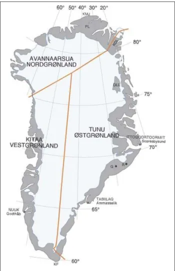
The traditional divisions of Greenland are illustrated in Fig. 1. East Greenland (‘Østgrønland’ in Danish, ‘Tunu’ in Greenlandic) comprises the entire eastfacing coast from Lindenow Fjord / Kanger lus suat -siaq at 60°30´N to Nordostrundingen at 81°21´N. The boundary between East Greenland and North Greenland (‘Nordgrønland’ in Danish, ‘Avannaarsua’ in Greenlandic) follows the SW–NE-trending water-shed in Kronprins Christian Land. This official boundary between North Greenland and East Green -land is followed in this volume. East Green-land can be conveniently divided into northern and southern re -gions at c.69°N, where a high ice cap and a long inhos-pitable coast have hindered migration of both the Inuit and land animals. This natural boundary at 69°N has been adopted in this volume as the southern limit of ‘northern East Greenland’.
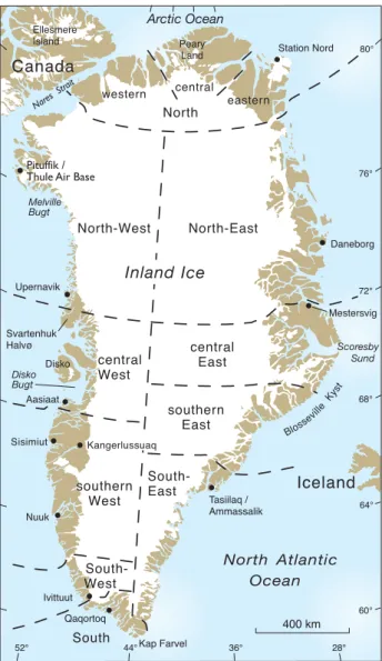
In 1976 the Geological Survey of Greenland (GGU) introduced regional subdivisions of all of Greenland that were considered more appropriate and useful for geological descriptions (Fig. 2; Escher & Watt 1976). For northern East Greenland the sub -divisions chosen essentially follow the informal usage of Lauge Koch’s expeditions and other workers, with the notable exception of the boundary between ‘North’ and ‘East’ Greenland, that is placed at an arti-ficial limit of latitude 79°30´N rather than following the official boundary (Fig. 1). The Survey subdivi-sions thus somewhat illogically place the northern-most segment of the east-facing coast of northern East Greenland in an enlarged ‘North Greenland’.
These Survey subdivisions were first used extensively in the Survey’s volume on the ‘Geology of Greenland’ (Escher & Watt 1976). The subdivisions were slightly amended by Ghisler (1990), mainly to bring the offshore divisions into line with the onshore divi-sions. While these revised subdivisions have no formal official status they have been very widely used in geological publications for the past 30 years. Indeed, the widespread usage particularly of the English term ‘North-East’ Greenland has led to the assumption that there is an equivalent Danish term for this part of East Greenland, such that ‘Nordøst -grønland’ is commonly encountered in Danish scien-tific publications and even in the formal title of ‘Nordøstgrønlands Nationalpark’ (NorthEast Green -land National Park).
Exploration and discovery
A detailed summary of all significant expeditions to northern East Greenland makes up the section on the
Exploration history of northern East Greenland (see page 17). In this section the main phases of explo-ration are briefly outlined. Maps 1–5 at the end of this volume give the most important place names used in northern East Greenland.
The former indigenous inhabitants of northern East Greenland have left abundant evidence of their presence in the form of house ruins and tent rings. The Inuit (Eskimo) cultures can be related to several
waves of immigration, of which the last few survivors of the Thule culture in northern East Greenland were probably the group of 12 encountered by Douglas Clav ering on Clavering Ø (74°15´N) in 1823 (Clave -ring 1830).
The earliest names still applied to East Greenland geographical features are those found in the Icelandic sagas, but these were mainly given for distant high mountains used as landmarks when sailing to the Norse settlements of South-West and West Green land
(Østerbygden and Vesterbygden; see Frontis piece)
from about AD 1000; these settlements gradually declined during the Little Ice Age that followed, with the last certain contacts with Europe about 1410.
Records of sightings of northern East Greenland were few until Henry Hudson’s voyage in 1607 that observed Hold with Hope at 73°30´N and reported abundant whales in the waters near Spitsbergen in the North Atlantic. Whalers of many nations flocked to Spitsbergen after 1612, and when whales became scarce there about 1630 they began to sail to East Green land waters in search of new hunting grounds. For more than 200 years, however, the coast of north-ern East Greenland, protected by a wide belt of pack ice, was widely considered inaccessible. It was not until 1822 that the British whaler William Scoresby Jr. made the first recorded landings around the mouth of Scoresby Sund (70°15´N). From the mid-1800s onwards there were numerous visits to East Green -land waters by whalers, and notably Norwegian seal-ers, who approached the land to supplement their catch with walruses and muskoxen.
The German explorer Karl Koldewey made an attempt to reach the North Pole via East Greenland in
1869, but his ship GERMANIAonly reached as far north
as Germania Havn (74°32´N) where it was forced to overwinter. During the autumn and the spring of 1870, sledge journeys were sent northwards as far as 77°N, and the region from 74° to 77°N was mapped in outline for the first time. The next major mapping expedition was the Danish expedition led by Carl Ryder in 1891–1892, that overwintered at Hekla Havn on Danmark Ø in the inner Scoresby Sund re -gion (70°–72°N). The system of fjords was explored by boat and on sledge journeys. In 1899, a Swedish expedition led by A.G. Nathorst visited the Kong Oscar Fjord region in a search for traces of Salomon Andrée’s balloon expedition that had vanished in 1897 during an attempt to reach the North Pole. During the summer of 1899, Nathorst explored Kej -ser Franz Joseph Fjord and the network of fjords
Canada Station Nord Ellesmere Island Peary Land western eastern central Daneborg Mestersvig Pituffik /
Thule Air Base
Melville Bugt Svartenhuk Halvø Disko Disko Bugt Upernavik Nuuk Aasiaat Kangerlussuaq Sisimiut Tasiilaq / Ammassalik Scoresby Sund Bloss eville
Ky st Ivittuut Qaqortoq Kap Farvel Nare
s St rait
central East
southern East
North - East
Iceland
North - West North cent ral West southern West South East South - West South Arctic Ocean
North Atlantic Ocean Inland Ice
400 km 72° 76° 80° 28° 36° 44° 52° 68° 64° 60°
centred on Kong Oscar Fjord (72°–74°N); the expedition surveyor, Per Dusén, carried out an epic pro gramme of mapping. The 1906–08 DanmarkEkspe -ditionen was the largest and most ambitious of early Danish expeditions, whose aims were to survey the large unknown region north of 77°N and to link up with the explorations of the American Robert E. Peary in North Greenland. Their success cost the lives of three members, of whom only the body of one has been found.
Norwegian activities entered a new phase with the first deliberate overwintering of a fox-trapping expedition in 1908–09. This was the start of the Norwe -gian–Danish trapper era that was to last until 1960. A series of expeditions from both nations overwintered at hunting stations with networks of small hunting huts surrounding them, trapping foxes and occasion-al wolves for their skins. The expansion of their rela-tive trapping terrains led to the trappers becoming involved in the Norwegian-Danish dispute over the sovereignty of East Greenland that was settled in Den mark’s favour at the International Court of Jus tice in The Hague in 1933. During World War II Da -nish and Norwegian hunters co-operated as mem bers of Nordøstgrønlands Slædepatrulje (forerunner of the present Sirius Sledge Patrol). Trapping was resumed after the war but was only sustained with government subsidies, and when subsidies were suspended, falling skin prices led to the effective cessation of hunting in 1960. The full story of the trapping era is related in fascinating detail by Peter Schmidt Mikkelsen (2008).
Members of the pioneer exploration voyages made occasional ascents of significant mountains, not ably Julius Payer during Karl Koldewey’s 1869–70 expedi-tion, but voyages aimed primarily at climbs of the highest known mountains in northern East Green land began with the British Cambridge expedition led by J.M. Wordie that travelled to East Green land in 1926
aboard the HEIMLAND. The professed objectives in
-cluded surveying and archaeology, but in-cluded a reconnaissance of a route to the 2940 m summit of Petermann Bjerg, first seen by Karl Kolde wey’s expe-dition in 1870. Wordie’s second expeexpe-dition in 1929 was rewarded by its successful ascent. An Italian expe-dition led by Leonardo Bonzi had sailed to East Greenland with a small climbing expedition in 1934 intending to make an attempt on the Watkins Bjerge, the range of high summits south of Scoresby Sund at around 69°N. Frustrated by ice conditions they explored the then unknown mountains of Volquaart
Boon Kyst (c.70°N). It was another British expedition
led by Augustine Courtauld and Lawrence R. Wager that made the first ascent of Gunnbjørn Fjeld (Hvit -serk) in August 1935; at 3694 m this is the highest peak in the Watkins Bjerge and the highest summit in Greenland. These early climbing expeditions were all reliant on boats for transport.
The competing interests of Danish and Norwe gian trappers led to signing of a treaty on East Green -land (Østgrøn-landstraktaten) in 1924 that allowed both nations to hunt, fish and carry out scientific investigations, but made no decision on sovereignty. However, the treaty specifically allowed Denmark to establish a colony in the Scoresby Sund region, and this proposal was brought to fruition thanks to the influence and initiative of Ejnar Mik kelsen. In 1925 the Greenlandic settlement of Scores bysund / Illoq -qor toormiut (Ittoqqortoormiit) was esta blished with the arrival of 70 Greenlandic settlers, mainly from Ammassalik / Tasiilaq. This act and the series of geo -logical expeditions initiated by Lauge Koch in 1926 were part of a strategy to expand Danish influence in northern East Greenland that eventually led to recog-nition of Danish sovereignty over all of Greenland.
Lauge Koch’s 1926–27 expedition was followed by summer expeditions in 1929 and 1930 and then 1931– 34 Treårsekspeditionen (the Three-year expedition), the largest and most comprehensive expedition hither-to sent hither-to East Greenland by Denmark, and also led by Lauge Koch. The Danish Geodætisk Institut (Geo -detic Institute) was an integral part of this expedition, and initiated a long-running programme of surveying leading to publication of 1:250 000 scale topographic maps. Treårsekspe di tionen was succeeded by the so-called Two-year expedition 1936–38, but the outbreak of World War II led to a halt in scientific activities. Lauge Koch’s expeditions continued from 1947, with an almost entirely geological focus, until the annual grants for field work were abruptly suspended after the 1958 season.
Significant activities by other nations included the seven voyages to the Scoresby Sund region by
Jean-Baptiste Charcot in his three-mast barque POURQUOI
PAS?, that included the setting up of the French Inter
-national Polar Year station 1932–33 in Scoresbysund / Illoqqortoormiut (Ittoqqortoormiit) and the four voy
-ages by the American Louise A. Boyd with the VESLE
-KARIthat visited most of the northern East Greenland
discovered by Lauge Koch’s expeditions nearby. The excellent 1800 m gravel airstrip has provided easy access to East Greenland for aircraft, and between 1954 and 1985 about 200 scientific and sports expedi-tions made use of the airstrip facility to reach East Greenland (Mestersvig was partly replaced in 1985 by the new airport built at Constable Pynt). From the mid-1950s onwards climbing expeditions paid partic-ular attention to the high mountains of the Stauning Alper that could be reached either by walking in, or by using small rubber boats for transport westwards along the coast (Bennet 1972). In 1974 the National Park in North-East Greenland was established and in 1988 was expanded westwards across North Green -land. At present it is the largest national park in the world. The Sirius sledge patrol, whose primary pur -pose is to patrol the uninhabited regions of northern East and North Greenland, also act as wardens in the National Park; visitors can only enter the National Park with permits issued by the Greenland authori-ties.
In 1967 the Geological Survey of Greenland sent a small reconnaissance expedition to the Scoresby Sund region. This was a precursor to the major re -gional geological mapping programme that was to prepare 1:500 000 scale geological maps of northern East Green land over a period of 30 years (Henriksen & Higgins 2008). Between 1978 and 1987 super wide-angle, vertical, aerial photographs were taken cover-ing all of Greenland, and a new network of fixed survey stations was established by the Geodætisk Institut (GI, Geodetic Institute, now part of Kort & Matrikelstyrelsen – KMS). KMS has produced a new topographic database for all of Greenland at a nomi-nal scale of 1:250 000 based on a combination of digi-tised existing published 1:250 000 scale map sheets with new maps drawn of previously unmapped areas (http://en.nunagis.gl). In connection with their re -gional geological mapping programmes, GGU/GEUS in co-operation with KMS has prepared topographic maps on a 1:100 000 scale for almost all of northern East Greenland.
The Sirius sledge patrol began to use Twin Otter aircraft for transport of personnel to and from Dane -borg in 1977, and from 1978 GI and GGU/GEUS expeditions to East and North Greenland also made extensive use of Twin Otter aircraft, whose short takeoff and landing (STOL) capabilities are ideal for transport of equipment and personnel between base camps and ‘unprepared’ natural landing strips (usual-ly river terraces; P.S. Mikkelsen 2006). Twin Otter
aircraft chartered from Iceland were also extensively used to supply the DYE stations (part of the Amer -ican Distant Early Warning radar system) on the Inland Ice, and to support the ice-drilling operations at various locations on the Inland Ice. The Icelandic Twin Otter pilots thus achieved considerable experi-ence in landing on snow and ice surfaces, and these skills have since been utilised by climbing expeditions to provide easy access to the high mountain ranges at around 69°N and other areas. Climbing expeditions have also been transported by Twin Otter to less precipitous areas otherwise difficult to reach, and many of these expeditions appear to have had as their sole objective the ascent of unclimbed peaks that they can then name after themselves or members of their families. However, no unofficial names given by climbers have been recognised by the Place Name Committee for Greenland since about 1960. In many remote nunatak areas the summits climbed may be only a few hundred metres above the surrounding glacier surfaces on which the Twin Otter aircraft landed. Claims by such expeditions to have made ‘30 first ascents’ are not unusual.
Scope of place names –
approved / unapproved
The bulk of this volume comprises a catalogue of approved and unapproved place names, arranged al -phabetically, that have been used on maps and in publications for localities in northern East Greenland (see page 117).
There are more than 3000 officially recognised place names in the region 69°–81°21´N, that is to say names that have been approved by the Place Name Com mittee for Greenland in Copenhagen (Sted navne
-udvalget) established in 1934. In 1979 Green land
achie ved Home Rule (Hjemmestyre), and in January 1984 the responsibility for place names in Greenland was transferred to Grønlands Sprognævn in Nuuk, the present Nunat Aqqinik Aalajangiisartut / Grønlands Stednavnenævn. A review of the work of the Place Name Committee for Greenland from 1934 to De -cember 1983 is the subject of the section that follows below: Official place names in Greenland (p. 13).
major-ity being rejected by the then Place Name Committee as being politically motivated, i.e. given to support Norwegian arguments for claims to sovereignty over parts of East Greenland. The detailed account of Norwegian and Danish trapping activities in north-ern East Greenland by P.S. Mikkelsen (1994, 2008) illustrates all their hunting stations and hunting huts, as well as the names and alternative names by which they are known. All these names receive brief mention here.
Unapproved names used on published maps by scientists of J.-B. Charcot’s expeditions (1925–36), Louise A. Boyd’s expeditions (1932, 1935, 1948) and in the 1968 edition of ‘Den Grønlandske Lods’ (this volume, published in Danish, is ‘The Greenland Pilot for East Greenland’) are also included.
Up to 1960 many of the names given by climbing expeditions to peaks in the Stauning Alper were ap -proved in danicised form, but the proposals for an increasing number of foreign-sounding names led to adoption of a more critical attitude to approval of names by the Place Name Committee for Greenland. The existence of detailed topographic maps of the Stauning Alper has allowed identification of the posi-tions of virtually all summits climbed up to 2008, and a special map on a 1:150 000 scale giving both ap -proved and unap-proved names applied to features in this region accompanies this volume as Map 5.
The large numbers of scientific, tourist and climb-ing expeditions that have visited, and continue to visit East Greenland have inevitably led to the naming of geographical features. Only a selection of unap-proved names used for significant reference localities receive mention here. In general, any names given after living persons, or used for minor peaks or varia-tions of climbers’ routes, are not included.
The most important source of information for this volume has been a near complete set of the minutes of the former Place Name Committee for Greenland; these include the documentation submitted to the committee and its various sub-committees in consid-ering place name proposals. This material was kindly lent to the author by Henry W. Bjørn of the then Geodetic Institute (Geodætisk Institute, now incor-porated into Kort- & Matrikelstyrelsen).
Acknowledgements
Peter Schmidt Mikkelsen (Rønde, Denmark) has kind -ly allowed me to add to this volume the many varia-tions of hut names used by trappers, and to quote the GPS latitudes and longitudes he has determined for all the hunting stations and hunting huts in East Greenland. This data, and the histories of the indi-vidual stations and huts, is taken from the English edition of his account of Danish and Norwegian trap-ping activities (P.S. Mikkelsen 2008).
Jan Løve (Skagen, Denmark) has for many years independently compiled data on place names used by expeditions to East Greenland, backing up his compi-lations with studies of published and unpublished diaries and other original material in various Danish archives. He has freely allowed me to make use of his deductions and conclusions with respect to specific names, thus correcting many of my errors and misin-terpretations; the most important corrections are acknowledged in the relevant individual entries. Jan Løve’s name compilations are on file (in Danish) on the website of the Danish Arctic Institute (www.arktisk -institut.dk: Østgrønlandske Stednavne).
Niels Henriksen (GEUS and Birkerød, Denmark) has been a constant source of support and encourage-ment throughout the compilation process for this volume. He was also leader of all the GGU/GEUS geo -logical mapping expeditions in which I have partici-pated. He has kindly read large sections of this vo lume, and provided many helpful comments and suggestions. Many individuals have kindly provided valuable information on place names given by themselves or by others during expeditions in which they participated. I am particularly grateful to: Svend Bendix-Almgren, John Cowie, Peter R. Dawes, Henrik Elling, J.D. (Di -dom) Friderichsen, John Haller, Colwyn Jones, David Malmquist, Arne Noe-Nygaard, N.E. Odell, Fritz H. Schwarzen bach, Cordelia Stamp, W. Stuart Watt and Anker Weidick.
The support of Velux Fonden is gratefully ac -know ledged, and is provided under the statutes of the Fund that encourage and give financial support to active pensioneers.
Professor N.E. Nørlund, Director of the Geodætisk Institut (Geodetic Institute), wished to solve the prob-lems of names given in various languages by expedi-tions of different nationalities, and also the use of East and West Greenlandic dialects, as East Greenland orthography diverges from that of West Greenland. Nørlund therefore took the initiative to form the Place Name Committee for Greenland (Sted navne kommis -sionen or Stednavneudvalget), under the auspices of the Scientific Commission for Greenland, with the aim of ratifying place names in Greenland. The initiative was prompted by the introduction of the regulations of journeys to and from Greenland issued by the Ministry for Shipping and Fisheries on 7 August 1930, of which
section VIII states (in translation): Expeditions that
wish to bestow place names on localities visited, must send proposals to the Danish Government, who will make the final decision.
The first meeting of the committee was held on 6 June 1933. The members included prominent Green -land administrators and scientists: Jens DaugaardJensen, Lauge Koch, Niels Erik Nørlund, Knud Ras mussen, William C. Thalbitzer, F.O. Jørgensen and Hother Ostermann. A second meeting was held on 15 November 1933. Officially the Place Name Com -mittee for Greenland was established on 1 Fe b ru ary 1934, when the Danish State Department issued a regulation announcing the establishment of a Place Name Committee, and stated that no place names given to Greenland localities by expeditions would be recognised by the Danish state until they had been approved by the committee.
Four meetings of the Place Name Committee were held in 1934, eight in 1935, and regular meetings were held subsequently until interrupted by the war years. One of the early decisions was to establish a sub-committee with the task of considering for approval all place names that had hitherto been used on pub lished maps. In respect of East Greenland, the systematic list-ing of published place names, and their approval or deletion continued until the 1940s. In the postwar pe riod, up to 31 December 1983, the subcommittee con -tinued to approve, modify or reject newly proposed place names, of which final approval was then made by the full committee. The minutes of the Place Name Com mittee for Greenland from 1933 onwards were for
-m erly accessible at the Danish Geo detic Institute, and the main activities and conclusions of the Com mittee
and its sub-committees rele vant to northern East
Greenland are summarised here. Greenland was grant-ed Home Rule in 1979, and took over responsibility for its place names on 1 Jan uary 1984; the Place Name Committee archives are now in Nuuk, Green land.
One of the early difficulties facing the committee was the significant differences between the West Green land dialect and that of East Greenland, and the consequent varied spelling of Greenlandic place names. At the first meeting of the committee in June 1933, Professor William C. Thalbitzer, the acknowl-edged expert on the East Greenlandic dialect, argued strongly for preservation of the East Greenland forms, rather than the ‘incorrect’ variations introduced in the Ammassalik / Tasiilaq region by West Green land in -ter pre-ters such as Hansêrak. At the third meeting it was commented that up to six dialect variations might be required to accurately reflect local usage. Jens Daugaard-Jensen, Director of Grønlands Styrelse (the Greenland administration), expressed his preference for the general application of Samuel Kleinschmidt’s orthography as practised in West Greenland, a view supported by C. Wilhelm SchultzLorentzen who pro -phesied (incorrectly) that there would be a general movement towards a common (West Greenland) dia -lect throughout Greenland. Thalbitzer threatened to resign from the committee at the 14th meeting in November 1935, partly on the grounds that his views on preservation of dialect forms were repeatedly overruled by other committee members, and partly due to disagreement on the principles for approving future place names. He confirmed his resignation at the 17th meeting in February 1937. The East Green -land dialect continues to thrive today in the East
Greenland towns of Illoqqortoormiut (Ittoq qor toor
-miit) and Tasiilaq / Ammassalik and outlying
settle-ments. The preferred East Greenlandic spelling of the
name of the town Scoresbysund is Ittoqqortoormiit,
and this is the spelling used by the inhabitants and on the official website (www.eastgreenland.com), but it is the West Greenland spelling Illoqqortoormiut that appears on official maps of Greenland.
Early meetings of the committee were marked by at times acrimonious discussion on the
tion of living persons in place names. The third meet-ing agreed that commemoration of livmeet-ing persons should be reduced to a minimum. An analysis of pre -vious practice in East Greenland presented at the sixth meeting revealed that 69% of the names pro -posed by A.G. Nathorst in 1899 commemorated persons, and that 54% of his names had been given after persons then still alive. The corresponding figures for G.C. Amdrup’s 1900 expedition to south-ern East Greenland were 80% and 74% respectively. At the fourth meeting reference was made to a some-what caustic letter by Ejnar Mikkelsen, who had drawn attention to some of the names on the 1932 edi tion of the 1:1 million scale topographic map com -piled by Lauge Koch (Geodætisk Institut 1932) that commemorated persons without the remotest con
-nection with Greenland (e.g. Anna Sten Gletscherand
Gerda Gletscherthat were named after actresses; see also Fig. 15). The large number of names arising from the activities of 1931–34 Treårsekspeditionen had also attracted unfavourable press comment because so many had been given after living persons.
Most of the names applied to geographical fea -tures during the 1931–1934 Treårsekspeditionen by Lauge Koch, and the scientists working under his lead ership, were published between the regulations of 1930 and 1934, and thus essentially prior to establish-ment of the Place Name Committee. Lauge Koch there fore argued, at the ninth meeting of the commit-tee in February 1935, that the decree of 7 August 1930 was the authority. Since this stated that names should be placed before the Government for approval, and since Koch was the appointed police authority in East Greenland during Treårsekspeditionen, then he was also (in his view) to be considered the Government authority and thus could approve his own names. As an additional argument for the blanket approval of all names given during Treårsekspeditionen, Koch cited the usage of his maps as documentary evidence at the International Court of Justice in The Hague, during the Danish–Norwegian controversy over the sover-eignty of East Greenland.
At the eighth meeting of the committee in Feb -ruary 1935, discussion on the commemoration of living persons in place names concluded with the recommendation that they should be avoided as far as possible, although this might prove difficult in practice. It was proposed that the committee should de -cide in individual cases, by vote if necessary. This decision was soon brought into effect with, at the 10th committee meeting in May 1935, the rejection of
many names proposed by J.G. Jennov (director of the Danish trapping company Nanok) and Ejnar Mik -kelsen. In rejecting Jennov’s names it was incorrectly stated that they had been given after the act of 1 Feb -ruary 1934; Jennov argued that many of his proposed names were given during the 1932 Gefion expedition and were in common use amongst Danish hunters. Jennov’s names were rejected for the third time in 1940, when a sub-committee suggested alternatives for three of Jennov’s disputed names (Tuxen Ø, Engel -hardt Sundand Frieda Sø), which became Nanok Ø, Jægersund and Gunner Andersen Sø. Nume rous sub -se quent attempts, by various expeditions, to intro-duce names obviously given after living persons were rejected. However, the regulations were often circum-vented, for example by geologists of Lauge Koch’s expeditions who would include personal names on their names lists with the discrete explanation ‘girl’s name’. Occasionally the Place Name Committee ap pears to have simply turned a blind eye to such pro -posals, and for example approved the names Ebbe Sø, Eigil Sø and Winston Bjerg proposed by the 1952–54 British North Greenland expedition, although they obviously commemorated Ebbe Munck, Eigil Knuth and Sir Winston Churchill (all then alive). Exceptions to the ‘living person’ rule are only officially allowed for the Danish Royal family, a practice that has con -tinued to the present day: e.g. Dronning Margrethe II Land (1990, on the occasion of the Danish Queen’s 50th birthday), Qeqertaq Prins Henrik (2004, on the occasion of the 70th birthday of the prince consort – the Danish Queen’s husband), Kronprins Frederik Land (2008, to commemorate the military service of crown-prince Frederik in the Sirius Sledge Patrol).
At the sixth meeting of the committee in March 1934 it was agreed to establish a sub-committee, the tasks of which were to go through all published Da -nish and foreign maps, and to make decisions on the danicised form of names to be approved for official usage. Name lists were drawn up for consideration by the Geodetic Institute, divided up for convenience into degrees of latitude, and with the names numb -ered consecutively. This system was also to apply to future proposed names, with the number given to each name following it throughout the entire ap -proval process.
the special Greenlandic ĸ introduced by Samuel Kleinschmidt. Amongst other proposals, usage of the
Danish aa form was preferred to the Swedish å (a
decision reversed in 1948). Hyphens were to be
avoid-ed, such that composite names such as Zoolog-dalen
were to be given in one word as Zoologdalen. Names given after persons were to be expressed in two or
more words (e.g. Milne Land, not Milneland. In
prac-tice it was the sub-committee that made recommen-dations on place names to be ap proved or rejected, their proposals then being placed before the full committee.
At the first meeting of the sub-committee the new names appearing on the maps produced by Norges Svalbard- og Ishavsundersøkelser (NSIU) on scales of 1:200 000 and 1:1 million in 1932 were considered, and with only a few exceptions all were rejected, on the grounds that they were politically motivated. A similar fate was to be meted out to the 299 new names given on the Norwegian 1:100 000 scale maps cover-ing Clavercover-ing Ø, Geographical Society Ø and Jordan Hill (Lacmann 1937). Although the committee ad -mitted that Lacmann’s maps contained significantly more detail than the best existing Danish maps, the procedure for approval of new names by Danish authorities had ‘not been followed’. In the event, a few names used on Clavering Ø were allowed by the sub-committee in 1939, but all others were rejected.
The sub-committee approved long lists of names given after localities in Denmark, notably those pro -posed by the surveyors of the Geodetic Institute. Some lists of names proposed by Swiss geologists or British scientists were adjudged too foreignsounding, even in danicised versions, and were rejected en tirely or replaced by the subcommittee’s own sug -gestions. Other lists of equally foreign-sounding names were approved. Although the committee as early as 1937 had expressed the view that large num -bers of foreign-sounding names were to be avoided as far as possible, the rule was inconsistently applied.
The indiscriminant usage of the genitive ‘s’ in
place names was raised at the eighth meeting of the committee in February 1935. Following the recom-mendations of the sub-committee, already published names that did not use the genitive ‘s’ were considered to have won recognition in that form, whereas newly proposed names should use the genitive form except where circumstances argued against it. However, in practice usage continued to be inconsistent, and the problem was raised again in the 1960s and 1970s when it was realised that charts published by the
Danish Hydrographic Office used one form, and the Geodetic Institute map sheets the other form. One of the last decisions of the Place Name Committee, to restore consistency, was to remove all the genitive ‘s’ endings previously approved.
To resolve the general problem in Greenland of the use of both Danish and Greenlandic names for the same feature, particularly as applied to towns and settlements, the principle of officially approving both Danish and Greenlandic place names was established. When Greenland acquired Home Rule in 1979 there was a subtle change in the ‘double’ name giving, with the Greenlandic town names taking precedence over the Danish equivalent. However, while in some cases the Danish town names gradually fell into disuse, in other cases the Danish town names were ‘officially’ abandoned by decision of the local town council leav-ing just the Greenlandic names. In some towns this policy went to the extremes of deliberately replacing all former Danish street names with Greenlandic alternatives. However, maps that show the original double names for Greenland towns still appear in the
most recent Greenland atlases (Berthelsen et al.1989;
Jakobsen et al.2000).
The regulations concerning travel to and from Greenland were revised in 1939 and 1948, and a regu-lation of 11 April 1949 re-organised the Place Name Committee, with Eske Bruun (then head of the Green -land administration) as chairman. The responsibili-ties of the new committee were essentially identical to those of the original committee. One of the early initiatives of the new committee was to undertake the systematic collection of Greenlandic place names used by local populations in Greenland. This process began in 1949, and in 1955 a two-man party from the Geodetic Institute visited Scoresbysund / Illoqqor -toor miut (Ittoqqortoormiit) and collected a total of about 190 names used locally, the majority being of the characteristic descriptive type. Following revision of the Danish orthography in 1948, the changes proposed were also applied to danicised place names in Greenland. The main change was that of the Da
-nish aato å, although Geodetic Institute map sheets
continued the old usage until 1954.
In 1973 a major revision of the Greenlandic ortho
-graphy was implemented (Greenland spelling re
the existing Geodetic Institute map sheets, and other atlases, used the old-style spelling, a systematic data-base of all place names in Greenland was compiled by the Geodetic Institute in 1986–1987, that includes both the old and new Greenlandic spellings for place names in Greenland. Both old and new spellings of Greenlandic approved names in northern East Green -land are given in this volume, with the main entry under the new spelling, with cross-references for all the old spellings.
In 1979 Greenland was granted Home Rule, which meant that Greenland acquired a special status with-in the Kwith-ingdom of Denmark, with its own parliament in Nuuk in West Greenland. As a result of this major
change many responsibilities previously carried out by Denmark on behalf of Greenland were transferred to Greenland. On 31 December 1983 the Place Name Committee for Greenland was disbanded, and respon-sibility for place names in Greenland was transferred to Grønlands Sprognævn, today the Nunat Aqqinik Aalajangiisartut / Grønlands Stednavnenævn / Green -land Place Names Committee.
In 2009 Greenland was officially granted Self-government (selvstyre), a further measure of inde-pendence from Denmark, with exceptions in respect of foreign policy and defence, but still with a
substan-tial annual subsidy of 3400 million Danish kroner (c.