Sci. Dril., 21, 29–40, 2016 www.sci-dril.net/21/29/2016/ doi:10.5194/sd-21-29-2016
© Author(s) 2016. CC Attribution 3.0 License.
Repor
ts
The Towuti Drilling Project: paleoenvironments,
biological evolution, and geomicrobiology of a
tropical Pacific lake
James M. Russell1, Satria Bijaksana2, Hendrik Vogel3, Martin Melles4, Jens Kallmeyer5, Daniel Ariztegui6, Sean Crowe7, Silvia Fajar2, Abdul Hafidz2, Doug Haffner8, Ascelina Hasberg4, Sarah Ivory1, Christopher Kelly1, John King9, Kartika Kirana2, Marina Morlock3, Anders Noren10,
Ryan O’Grady10, Luis Ordonez6, Janelle Stevenson11, Thomas von Rintelen12, Aurele Vuillemin5, Ian Watkinson13, Nigel Wattrus14, Satrio Wicaksono1, Thomas Wonik15, Kohen Bauer7, Alan Deino16,
André Friese5, Cynthia Henny17, Imran18, Ristiyanti Marwoto17, La Ode Ngkoimani19, Sulung Nomosatryo5, La Ode Safiuddin19, Rachel Simister7, and Gerald Tamuntuan20
1Department of Earth, Environmental, and Planetary Sciences, Brown University, 324 Brook St., Providence,
RI, 02912, USA
2Faculty of Mining and Petroleum Engineering, Institut Teknologi Bandung, Jalan Ganesa 10, Bandung, 50132,
Indonesia
3Institute of Geological Science & Oeschger Center for Climate Change Research, University of Bern,
Baltzerstrasse 1+3, 3012 Bern, Switzerland
4Institute for Geology and Mineralogy, University of Cologne, Zülpicher Str. 49a/b, 50674 Cologne, Germany
5Helmholtz Centre Potsdam, GFZ German Research Center for Geosciences, Telegrafenberg, Building C,
14473 Potsdam, Germany
6Department of Earth Sciences, University of Geneva, rue des Maraichers 13, 1205 Geneva, Switzerland
7Department of Microbiology and Immunology, University of British Columbia, Vancouver, BC, Canada
8Great Lakes Institute for Environmental Research, University of Windsor, Windsor, Ontario, N9B 3P4, Canada
9Graduate School of Oceanography, University of Rhode Island, Narragansett, RI, 02882, USA
10LacCore, Dept. of Earth Science, University of Minnesota, Minneapolis, MN, 55455, USA
11School of Culture, History and Language, Australia National University, Acton, ACT 2601, Australia
12Museum für Naturkunde, Leibniz Institute for Evolution and Biodiversity Science, Invalidenstr. 43, 10115
Berlin, Germany
13Dept. of Earth Sciences, Royal Holloway University of London, Egham, Surrey TW20 0EX, UK
14Large Lakes Observatory, University of Minnesota Duluth, Duluth, MN, 55812, USA
15Liebniz Institute for Applied Geophysics, Stilleweg 2, 30655 Hanover, Germany
16Berkeley Geochronology Center, Berkeley, CA, 94709, USA
17Research Center for Limnology, Indonesian Insitute of Sciences (LIPI), Jl. Raya Bogor m 46, Cibinong, West
Java, Indonesia
18Geological Department, Universitas Hasanuddin, Kampus UNHAS Tamalanrea, Makassar, 90245, Indonesia
19Faculty of Earth Sciences and Technology, Haluoleo University, Kampus Baru Unhalu Anduoonoho,
Kendari, 93232, Indonesia
20Department of Physics, Faculty of Mathematics and Natural Sciences, Sam Ratulangi University, Jl. Kampus
Unsrat, Manado, 95114, Indonesia
Correspondence to:James M. Russell (james_russell@brown.edu)
Received: 17 June 2016 – Revised: 29 June 2016 – Accepted: 30 June 2016 – Published: 27 July 2016
environmental changes on the biological evolution of aquatic taxa, and the geomicrobiology and biogeochemistry of metal-rich, ultramafic-hosted lake sediments through the scientific drilling of Lake Towuti, southern Sulawesi, Indonesia. Lake Towuti is a large tectonic lake at the downstream end of the Malili lake system, a chain of five highly biodiverse lakes that are among the oldest lakes in Southeast Asia. In 2015 we carried out a scientific drilling program on Lake Towuti using the International Continental Scientific Drilling Program (ICDP) Deep
Lakes Drilling System (DLDS). We recovered a total of ∼1018 m of core from 11 drilling sites with water
depths ranging from 156 to 200 m. Recovery averaged 91.7 %, and the maximum drilling depth was 175 m below the lake floor, penetrating the entire sedimentary infill of the basin. Initial data from core and borehole logging indicate that these cores record the evolution of a highly dynamic tectonic and limnological system, with clear indications of orbital-scale climate variability during the mid- to late Pleistocene.
1 Introduction
The Towuti Drilling Project (TDP) is an international re-search program, whose objective is to understand long-term environmental and climatic change in the tropical western Pacific, the impacts of geological and environmental changes on the biological evolution of aquatic taxa, and the geomi-crobiology and biogeochemistry of metal-rich, ultramafic-hosted lake sediment. To accomplish this goal, the TDP re-covered over 1000 m of sediment core from the floor of Lake Towuti, the largest tectonic lake in Southeast Asia. Analysis of these cores is just beginning, but will provide a new long, high-resolution record of tropical western Pacific paleohy-drology during the Pleistocene, information on the age and history of the lake and the limnological conditions that gave rise to Towuti’s endemic fauna and flora, and new insight into the microbial processes operating at depth in Towuti’s sediments and their effects on sediment mineralogy and bio-geochemistry.
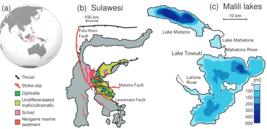
Lake Towuti is a large tectonic lake at the downstream end of the Malili lake system (Fig. 1), a set of five ancient,
tec-tonic lakes that have formed over the past∼1.5 million years
on the island of Sulawesi, Indonesia (Haffner et al., 2001; Lehmusluoto et al., 1995; Russell and Bijaksana, 2014). These are the oldest lakes in Indonesia and are thought to contain the longest continuous terrestrial records of climate in the Indo-Pacific Warm Pool (IPWP), a vast pool of warm surface waters in the western tropical Pacific. The IPWP ex-erts enormous influence on global climate through its inter-actions with the El Niño–Southern Oscillation (ENSO), the Australasian monsoons, and the Intertropical Convergence Zone (ITCZ) (Chiang, 2009; Clement et al., 2001; Seager and Battisti, 2007) and through its influence on the concen-tration of atmospheric water vapor – the Earth’s most impor-tant greenhouse gas (Pierrehumbert, 1999, 2000). Our ability to make accurate predictions about future climate, and in par-ticular future precipitation, thus rests on our understanding of the tropical Pacific climate under different climate boundary conditions than today. Global climate models exhibit signif-icant inter-model differences in their simulations of recent and future precipitation change over the IPWP (Kumar et
al., 2013; Meehl et al., 2007), as do simulations of IPWP precipitation under glacial boundary conditions (DiNezio et al., 2011; DiNezio and Tierney, 2013), motivating scientific drilling at Lake Towuti.
In recent years the global lakes drilling program under the auspices of the International Continental Scientific Drilling Program (ICDP) has made substantial contributions to under-standing Pliocene–Pleistocene climate variability, including multiple paleoclimate records from the northern and southern tropics. These records, together with many long speleothem data sets, have highlighted the importance of 21 000-year cy-cles in subtropical rainfall, indicating strong forcing of the strength of the monsoons by orbital precession (e.g., Fritz et al., 2007; Hodell et al., 2007; Scholz et al., 2007; Wang et al., 2008). Despite these advances, we lack long records of ter-restrial paleoclimate from equatorial regions and particularly the Indo-Pacific. Previous sedimentary records from Lake
Towuti span the last∼60 kyr BP, and contain an intriguing
record of past climate that differs markedly from that of the subtropics (Russell et al., 2014). In particular, we observed grassland expansion, lowered lake levels, and strong dry-ing durdry-ing the last glacial maximum (LGM) relative to both
marine isotope stage 3 (∼30–60 kyr BP) and the Holocene
(Costa et al., 2015; Konecky et al., 2016; Russell et al., 2014; Vogel et al., 2015). The strong glacial–interglacial signal at Lake Towuti challenges the hypothesis that tropical hydro-climate is predominantly controlled by precessional orbital forcing, with little influence of glacial–interglacial changes in climate boundary conditions (Carolin et al., 2013; Meck-ler et al., 2012). A critical goal of TDP is, therefore, to ob-tain a continuous sedimentary record to document orbital-scale patterns of climate change spanning as many glacial– interglacial cycles as possible to test and differentiate the forcings that govern Indo-Pacific rainfall variations.
(b) Sulawesi
Ophiolite Undifferentiated mafic/ultramafic
Neogene marine sediment Thrust Strike-slip
100 km
Schist
Palu-Koro Fault
Matano Fault
Lawanopo Fault
(c) Malili lakes
Lake Towuti Lake Matano
Lake Mahalona Mahalona River
Larona River
100 0 150 200 300 400 600
[m]
10 km
(a)
Figure 1.Overview map of the study area showing(a)the location of Sulawesi in the Indo-Pacific region,(b) the regional geology of Sulawesi (modified after Kadarusman et al., 2004), and(c)the configuration of the Malili lake system.
sediments are extremely Fe rich and thus stand out as an end-member microbial habitat. The prevalence of Fe-rich sedi-mentary rock units in the Precambrian suggests that ferrugi-nous conditions were a prominent feature of the deep ocean throughout the Earth’s history (Poulton and Canfield, 2011), and with mounting evidence for Fe-rich Martian soils and lake sediments dominated by ultramafic weathering products (e.g., Ehlmann et al., 2008), the study of an active biosphere in environments such as Towuti is timely and critical. More-over, Towuti’s pelagic microbial ecology, biogeochemistry, and sediment mineralogy are tightly linked to climate vari-ations through varying lake mixing regimes, soil erosion, and weathering (Costa et al., 2015; Tamuntuan et al., 2015). These processes are directly or indirectly responsible for the production and deposition of many paleoclimate proxies, and postdepositional alteration of those proxies is often linked to the activity of sedimentary microorganisms. In light of these issues, a critical component of the TDP is to investigate the microbial community at depth and its effects on iron miner-alogy, carbon, and metal cycling using a variety of state-of-the-art geochemical, molecular genetic, and isotopic tools.
Towuti is surrounded by one of the most diverse tropical rainforests on Earth, and harbors endemic species flocks of fish, snails, shrimp, crabs, and other organisms. Identifying the role of past environmental change in governing the evo-lution and biogeographical range of these organisms will be crucial for identifying conservation priorities and strategies to cope with anthropogenic climate change and land use. In terms of its flora, Sulawesi lies within one of the world’s most biologically complex and diverse regions and is home to fundamentally important faunal and floristic boundaries such as the famed Wallace Line (which separates fauna of Australian and Asian origin). The regional phytogeography is controlled by these diverse geological origins and by sub-sequent modification by climate variations, particularly the glacial–interglacial cycles, which have influenced the
con-nectivity between adjacent islands as well as drought toler-ance and resilience of the regional flora (Cannon et al., 2009; van Welzen et al., 2011). Understanding the past dynamics of these forest communities therefore is critical for our un-derstanding of their response to future change. Faunally, the Malili lakes offer by far the most outstanding example of la-custrine biological evolution in Southeast Asia, with paral-lel adaptive radiations of gastropods (Rintelen et al., 2004), crabs (Schubart et al., 2008), shrimps (Rintelen et al., 2010), and fishes (Herder et al., 2006). Genetic and morphological data indicate multiple colonizations of the lakes in several of these groups; a high level of endemism within each lake, sug-gesting allopatric speciation despite the presence of riverine connections among the lakes; and intralacustrine diversifica-tion through shifting trophic structure suggesting ecological speciation (Rintelen et al., 2012). These faunal data thus have strong links to the climatic, limnological, and geological evo-lution of Lake Towuti. Drilling in Lake Towuti will document the environmental and climatic context that shaped the evo-lution of these unique lacustrine and terrestrial ecosystems, and their resilience to long-term environmental change.
These outstanding characteristics motivated the TDP, un-der the auspices of the ICDP. Through continuous coring of the entire sedimentary sequence of Lake Towuti, the project aims to
1. reconstruct long-term hydrologic change in central In-donesia in order to understand the processes control-ling long-term climate change in the tropical western Pacific;
2. discover the micro-organisms living in Towuti’s metal-rich sediments, and determine their impacts on the lake’s sediments and biogeochemistry;
Figure 2.A bathymetric map of Lake Towuti showing the location of core sites discussed in the text.
4. document the age of Lake Towuti, its long-term limno-logical history, and the environmental background shap-ing the diversification of Towuti’s endemic flora and fauna.
2 Study site
Lake Towuti is located near the Equator (2.75◦S, 121.5◦E;
Figs. 1 and 2) at 318 m above sea level in central Sulawesi, Indonesia. The island of Sulawesi has a complex tectonic history. At the large scale, a complex zone of deformation extends across central Sulawesi and absorbs the collision of Australia with Asia (Sundaland). Three major sinistral strike-slip fault systems accommodate this motion: the Palu-Koro, Matano, and Lawanopo faults. Lake Towuti and neighboring lakes occupy small transtensional basins along the Matano Fault. Northeast of Sulawesi, the Molucca Sea subduction zone accommodates convergence between the Philippine Sea Plate and Sundaland, giving rise to extensive volcanic fields in northern Sulawesi (Hamilton, 1988).
Sulawesi is composed of four elongate “arms”, which broadly correspond to lithotectonic units (Hamilton, 1979). The southeast arm, which houses Lake Towuti, is dominated by the highly tectonized East Sulawesi Ophiolite, which is inter-thrust with Mesozoic and Cenozoic sediments. These rocks are comprised of ultramafic mantle peridotites (lherzo-lites and harzburgites), cumulate gabbros, and basalts of nor-mal mid-ocean ridge composition (Kadarusman et al., 2004; Monnier et al., 1995). The ophiolites have sourced large lat-eritic nickel deposits that have attracted the mining industry since the beginning of the 1970s, with active operations and extensive infrastructure in the region currently operated by PT Vale Indonesia (a subsidiary of Vale SA).
The three largest of the Malili lakes, Matano, Mahalona, and Towuti, are connected with surface outflow from Matano to Mahalona to Towuti via the Mahalona River, the largest
river inflow to the lake (Fig. 2). Lake Towuti is the largest of
the Malili lakes, with a surface area of 560 km2and a
max-imum water depth of 200 m (Haffner et al., 2001; Lehmus-luoto et al., 1995). A chain of islands divides the lake into two basins: a larger northern basin that contains the deepest part of the lake, and a smaller southern basin. Lake Towuti is presently hydrologically open with outflow to the southwest through the Larona River, which flows to the Bay of Bone.
Lake Towuti experiences a tropical humid climate. The
re-gion receives∼2700 mm yr−1 of precipitation, with a wet
season from December–May, during which strong north-easterly flow, warm sea surface temperatures (SSTs), and local convective activity (Hendon, 2003) maintain pre-cipitation at > 250 mm month−1. Precipitation falls below
150 mm month−1from August–October, when southeasterly
flow and cool SSTs suppress regional convection. This circu-lation and precipitation seasonality is characteristic of much of southern Sumatra, southern Borneo (Kalimantan), Java, and the Moluccas (Hendon, 2003), suggesting our record should represent climate change across a broad swath of cen-tral and southern Indonesia (Aldrian and Susanto, 2003; Ko-necky et al., 2016).
Towuti’s surface water temperatures vary between ∼29
and 31◦C. The lake water column is thermally stratified, with
seasonal mixing to a depth of∼100 m (Costa et al., 2015).
Lake Towuti is relatively dilute (210 µS cm−1) and
circum-neutral (pH∼7.8) with a chemistry dominated by Mg and
HCO−
3 (Haffner et al., 2001; Lehmusluoto et al., 1995). The
lake is among the least productive tropical lakes on Earth (ultraoligotrophic), likely due to low nutrient delivery from
intensely weather soils and sedimentary PO3−
4 trapping by
very high Fe concentrations. The surface waters are well-oxygenated, but hypoxic to anoxic conditions exist below
∼120 m depth allowing for the development of ferruginous
conditions with very low concentrations of dissolved sulfur.
3 Core site selection
Site selection for the TDP was guided by three surveys car-ried out between 2007 and 2013 that collected over 1000 km of seismic reflection data and piston cores that document the nature of the upper 10–20 m of Towuti’s sediment col-umn. Seismic data include “CHIRP” data acquired with
an Edgetech™ 216s Towfish with a topside 3200XS
col-lection system, and both single channel and multichannel
data collected using a Bolt™5 in3airgun and a 150 m long
Geometrics™ GeoEel solid digital streamer with 24
chan-nels.
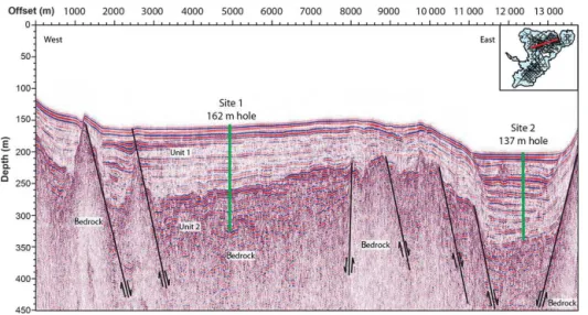
The seismic data revealed two major sedimentary units in Lake Towuti (Fig. 3; Russell and Bijaksana, 2012). Unit 1 consists of a well-stratified sequence that extends from the
lake floor down to∼100 m sub-bottom, and is characterized
geomet-Figure 3.Seismic reflection profile oriented WSW–ENE over Lake Towuti’s northern basin (see inset for line position) crossing TDP Sites 1 and 2. Thick green lines show the borehole depths for TDP-TOW15-1B and TDP-TOW15-2A. Seismic Units 1, 2, and bedrock are labeled, and major faults are indicated by thin black lines.
ric relationships such as angular contacts that would indicate large lake-level changes, suggesting stable, continuous, fine-grained sediment deposition in Towuti’s deep basins. Some of the thickest Unit 1 accumulations are found in the deep-est basin of Lake Towuti, located near the northern shore of the lake. This basin receives distal deltaic sediments derived from the Mahalona River, which drains the upstream lakes Matano and Mahalona.
Our piston coring survey sampled only the uppermost sediments of Unit 1, but confirmed the observations from our seismic reflection data. A core collected at site TOW-9 (Fig. 2) documented continuous, fine-grained sedimentation in the central part of Towuti’s northern basin, with sedimenta-tion rates of∼5.5 kyr m−1during the past∼60 kyr BP (Rus-sell et al., 2014). We found very frequent distal deltaic tur-bidites in the deepest part of the lake (Site Co1230, Fig. 2), particularly during lake-level low stands that remobilize delta topset beds and force deltaic progradation (Vogel et al., 2015). Elsewhere, the piston cores generally consisted of fine-grained clays interbedded with more or less frequent tur-bidites. Turbidites increased in frequency and thickness with proximity to the Mahalona River delta, but were also com-mon near shorelines or in the deepest parts of sub-basins within the lake, perhaps originating from seismically induced failure of poorly consolidated sediments in this tectonically active basin.
Unit 1 is underlain by Unit 2, a more poorly stratified unit
that varies between a few tens to∼150 m in thickness. Unit 2
is characterized by a range of sediment types, from continu-ous, sub-parallel reflectors to short, discontinuous reflectors. Prior to drilling, Unit 2 was interpreted to reflect alternating fluvial and lacustrine sedimentation that occurred during the initial stages of formation of Lake Towuti. Drilling Unit 2 could provide insight into Lake Towuti’s age, processes of
basin formation, and the early lake stages, which is infor-mation critical to understanding the biological evolution of Towuti’s endemic fauna.
Based upon these data, we selected three primary drilling sites, between 156 and 200 m water depth, and with drilling
targets between∼130 and∼175 m sub-bottom. Our primary
goals in selecting drilling sites were to recover
1. high-quality continuous sections with as few turbidites as possible through Unit 1 for paleoclimate, paleolim-nological, and geomicrobiological studies;
2. a distal record of the Mahalona River system to moni-tor changes in deltaic sedimentation forced by lake-level changes and possible changes in the river system itself signaling changes in the hydrological connectivity of lakes Towuti, Mahalona, and Matano;
3. as long a section as possible through Unit 2, preferably at sites containing more lacustrine than fluvial sedimen-tation (fine-grained deposits).
Site 1 is TDP’s primary drilling target, located in the
cen-tral part of Towuti’s northern basin in∼156 m water depth
Figure 4.Expanded seismic reflection sections over the TDP core Sites 1(a), 2(b), and 3(c), with seismic Units 1 and 2, and bedrock labeled. Black lines show the positions and depths of TDP-TOW15-1B, TDP-TOW15-2A, and TDP-TOW15-3A.
by turbidites or other event deposits. Seismic data also im-aged approximately at least 75 m of sediment in Unit 2, in-cluding two intervals marked by roughly parallel acoustic
re-flectors centered at∼115 and∼160 m depth, indicating
rel-atively well-stratified sediments. Our primary goals at Site 1 were to obtain overlapping triplicated cores through the
up-per∼100 m, to obtain 100 % recovery of Unit 1, and to
re-cover as complete a section as possible of Unit 2 including cores to bedrock if possible.
Site 2 is located in the deepest part of Lake Towuti at 200 m water depth (Fig. 4b). Piston core Co1230 indicates that this site receives distal deltaic sediments derived from the Mahalona River, and seismic reflection data indicated a major change in the acoustic character of the sediments at ∼65 m depth that could reflect the beginning of distal deltaic sedimentation from the Mahalona River. The principle ob-jectives of drilling this location were therefore to provide a record of lake-level changes and/or major changes in the hydrological connection between lakes Towuti, Mahalona, and Matano through study of these distal deltaic deposits. Changes in the amount and style of clastic sedimentation, together with sediment provenance studies, at Site 2 may provide relatively direct insight into the history of hydro-logical connectivity between the Malili lakes, with important implications for the biological, hydrological, and geological evolution of Lake Towuti. Seismic reflection data suggested ∼130 m of well-stratified lacustrine sediment at this site, so our goal was to recover duplicate overlapping cores to the Unit 1–Unit 2 boundary.
Site 3 was originally proposed for Towuti’s southern basin to provide a sedimentary sequence unaffected by sedimen-tological changes associated with the evolution of the Ma-halona River, in order to test the reproducibility of our recon-structions of terrestrial weathering and sediment supply ob-tained from Site 1. The long transit times to Towuti’s south-ern basin, combined with equipment failures, forced us to relocate Site 3. An alternate site was selected to the west of Site 1 in 159 m water depth (Fig. 4c). Seismic data suggested that this site could have the most continuous lacustrine sedi-mentation through the time period represented by Unit 2, as the site is located in a small structural sag that may have
al-lowed for continuous lacustrine conditions while other sites in the basin were dry. Our goal at this site was to obtain over-lapping duplicated cores as deeply as possible.
4 Drilling, logging, and on-site geomicrobiological operations
Drilling in a remote part of central Indonesia was a difficult logistical undertaking. Major logistical activities began in September 2014, when we shipped 14 containers of drilling equipment and supplies from the United States of America to the town of Sorowako, Sulawesi Selatan, Indonesia; initi-ated research permit applications and paperwork; began on-site construction of a dock and crane pad from which we could launch the drilling barge; and developed agreements with PT Vale Indonesia for local logistical support includ-ing the use of cranes, housinclud-ing, and assistance with environ-mental, health, and safety planning. We shipped the GFZ “Buglab” to Sorowako to support on-site sample processing for geomicrobiological investigations, as well as borehole logging equipment from the Leibniz Institute for Applied Geophysics (LIAG), Hanover, Germany. Logistical prepara-tions were completed in May 2015, when the drilling team arrived and set up on-site analytical facilities and the drilling barge on Lake Towuti’s shore.
Drilling commenced at Site 1 on 23 May 2015 using the ICDP Deep Lakes Drilling System (DLDS) operated by DOSECC Exploration Services. Boreholes were drilled us-ing PQ (122.6 mm hole, 66 mm core) diameter drill strus-ing, which uses the hydraulic piston corer (HPC) for soft sedi-ment and the “Alien” rotating corer to recover more resis-tant lithologies; attempts to recover more resisresis-tant lithologies with the Extended Nose Corer (EXN) resulted in poor core recovery and quality. All cores were recovered into standard butyrate liners. Geophysical downhole logging data, includ-ing natural gamma radiation, magnetic susceptibility (MS), electrical resistivity, temperature, acoustic velocity, vertical seismic profiles, and borehole diameter and dip, were mea-sured at varying depth resolutions in a subset of holes.
A multisensor core logger (MSCL; Geotek Ltd.) was used
veloc-0
20
40
60
80
100
120
140
160 3A 3B 1A 1B
0
20
40
60
80
100
120
140
160
1D 1E 1F 2A
0
20
40
60
80
100
120
140
160
2B 2C
Depth (mblf)
Hydraulic piston corer Alien
Extended nose Gap
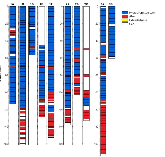
Figure 5.Core recovery from the TDP drill sites in Lake Towuti. Colors indicate the various tools used to recover cores from all TDP sites except 1C. White boxes indicate intervals that were not recovered.
ity data on whole cores in an on-site laboratory immediately
after drilling, though thepwave velocity data were of
low-quality due to gas expansion in most cores. At Hole 1A, also known as the “bughole”, a fluid contamination tracer was used to aid geomicrobiological sampling. Samples were col-lected from cores from Hole 1A immediately upon recovery on the drilling barge to measure trace and redox-sensitive gas concentrations (such as methane), and over 450 sam-ples were subsequently processed in the BugLab for analyses of pore-water chemistry, cell counting and microbial finger-printing, experiments on microbial turnover and processes, and organic geochemistry.
Upon conclusion of drilling operations, cores were shipped via air freight to LacCore, the National Lacus-trine Core Facility at the University of Minnesota, USA, for full processing, description, scanning, and subsampling. There, physical properties for whole cores were analyzed via
MSCL-S to obtain p wave velocity, gamma density, loop
MS, electrical resistivity, and natural gamma radiation data at intervals of 2–4 cm. After splitting, cores were logged using an MSCL-XYZ to obtain high-resolution MS and color re-flectance spectrophotometry at 0.5 cm resolution. Split cores
were cleaned and scanned with a Geotek™ Geotek Single
Track Core Imaging System (MSCL-CIS) digital linescan imager. Visual core description and smear slide analyses were carried out to classify the sediment into major com-positional units, and subsamples were extracted at intervals coordinated to obtain stratigraphically equivalent samples for sedimentological, geochemical, and paleoecological parame-ters. All cores received identical treatment except cores from Hole 1C, which were left in Indonesia to aid in educational and outreach activities, and cores from Hole 1A, many of which were completely sampled in the field leaving no mate-rial for logging nor core description.
5 Initial coring and core description results
TDP drilled 11 boreholes in total (Table 1), although sev-eral of these were relatively short due to twist offs that broke drilling rods, or other equipment malfunctions. In total we
drilled ∼1228 m of sediment and recovered ∼1018 m of
core within the intervals where coring was attempted, result-ing in a recovery of 91.7 % (Fig. 5). Recovery was
1), but much lower in Unit 2 due to the presence of coarse-grained unconsolidated lithologies. We acquired borehole logging data from three holes, though not all parameters were logged at all depths due to borehole collapse in shallow un-consolidated sediment. Attempts to collect vertical seismic profiles at Site 1 were unsuccessful due to equipment mal-function, and were not repeated at other sites.
Six boreholes were drilled at Site 1 yielding approxi-mately 524 m of core. Drilling commenced at Site 1A on
23 May 2015, and penetrated ∼115 m reaching∼10 m
be-low the Unit 1–Unit 2 boundary. Our geomicrobiology team did extensive sampling of this core in the field. The ma-jority of the core consists of relatively soft clays that were cored with the HPC; however, we encountered four relatively
hard beds between∼25 and 70 m sub-bottom that required
drilling with the Alien tool. These hard beds were later deter-mined to be tephras, which, despite their deposition as airfall, were frequently semi-lithified. Drilling the soft sediments surrounding these tephras with the Alien tool resulted in sig-nificant homogenization and contamination of these cores, as revealed by our contamination tracer, will be published elsewhere. We subsequently adjusted our drilling strategy to maximize recovery of the tephras while minimizing distur-bance of the soft clays. Drilling was terminated in this hole upon encountering the first resistant sand bed, in order to start a new hole to ensure duplication of the upper 100 m of the sediment column.
Our second hole, 1B, was our deepest hole at Site 1, extending to 162 m below lake floor (m b.l.f.). The upper
∼115 m b.l.f. was very similar to Hole 1A, but the lower
∼46 m b.l.f. consisted of a variety of coarser-grained litholo-gies that resulted in relatively low recovery. Coring was
ter-minated at ∼162 m b.l.f. after coring∼0.40 m of bedrock,
which consisted of a lithified mafic conglomerate that ap-pears similar to Eocene-aged deposits that occasionally out-crop in the region.
While drilling Hole 1B, we began to experience problems with the hydraulic power system of the drilling rig, and af-ter completing Hole 1B, we completely lost rig function. Drilling operations had to be shut down for 18 days in or-der to replace the main hydraulic pumps of the rig. We then repositioned the drill rig and cored a short hole, 1C, which
extended only ∼5.5 m b.l.f. After correcting additional
hy-draulic problems identified while drilling this hole, we drilled three additional holes at Site 1 (1D, 1E, and 1F). Hole 1D
extends ∼54 m b.l.f. with excellent recovery, and was
ter-minated due to a stuck tool. We repositioned and reamed
to∼45 m b.l.f. with a non-coring assembly (NCA) at Hole
1E, and then cored the interval from 45 to∼129 m b.l.f. with
91 % recovery. In light of the various equipment issues and difficulties recovering sediments around tephras in Unit 1 and coarse sediments in Unit 2, we drilled a sixth and final hole,
1F. This hole extends to∼154 m b.l.f., with nearly 95 %
re-covery, and was terminated when we encountered gravel that, based on 1B, cap a bedrock–soil–fluvial sequence. Holes 1B
C
la
y
Sil
t
San
d
G
rave
l
Depth (mblf)
0
8 0 2 0 4 0 6 0
1 0 0 1 2 0 1 4 0 1 5 6
Green-gray clay Diatom ooze
Gap Peat Bedded to massive sand Red-gray clay Silt Tephra
200 600 1000
Magnetic Susc.
SI x 10-6
Lithology
Gravel
Interbedded sands, silts and clays (turbidites)
Legend
Figure 6.Summary stratigraphy of core TDP-TOW15-1F, based on initial core descriptions. Lithology data are based upon visual and smear slide descriptions, and are rendered in PSICAT. Magnetic susceptibility data measured on the whole (unsplit) core from the Geotek MSCL are shown in the central panel, and at far right is the key to the lithologic symbols. Blank (white) areas indicate zones with no recovery.
and 1F were successfully logged for various geophysical pa-rameters, though barge movement and borehole collapse
pre-vented logging of the upper∼20 m of sediment.
Core 1F is the most complete section from Site 1 and its lithology is representative of the section recovered from this site (Fig. 6). The basal sediments consist of a variety of lithologies including alternating gravels, poorly to well-sorted sands, silts, clayey silts, and peats. This unit is capped
by a∼2.5 m thick woody peat at∼100 m b.l.f., which
cor-relates to the transition from Unit 2 to Unit 1 in seismic re-flection data. The upper 100 m of sediments consist largely of alternating thinly bedded to massive dark reddish-gray to dark-green gray clays. Normally graded silts (turbidites)
are relatively rare but more common in the lower ∼50 m
of this interval, and we discovered ∼14 light gray tephras
that range from∼1 to∼40 cm thickness and are scattered
through the upper∼95 m. The source of these tephras is
Table 1.Summary information about TDP drill sites. Drilled depth indicates the bottom depth of each hole; % recovery indicates the meters of core recovered within the depth intervals where coring was attempted, and thus excludes intervals drilled with a non-coring assembly.
Labels Water depth Core length Drilled depth Recovery Borehole Remarks
(m) (m) (m b.l.f.) (%) logging
Site 1
TDP-TOW15-1A 156 105.837 113.58 93.2 N Geomicrobio Site
TDP-TOW15-1B 156 137.871 161.7 85.3 Y
TDP-TOW15-1C 156 4.455 5.64 79.0 N Rig failure
TDP-TOW15-1D 156 53.21 53.91 98.7 N Ended in twist off
TDP-TOW15-1E 156 76.19 128.72 91.0 N Continuation of 1D
TDP-TOW15-1F 156 145.965 154.06 94.7 Y
Site 2
TDP-TOW15-2A 201 134.515 137.58 97.8 Y
TDP-TOW15-2B 201 103.918 104.55 99.4 N Ended in twist off
TDP-TOW15-2C 201 34.175 133.21 82.9 N Continuation of 2B
Site 3
TDP-TOW15-3A 159 166.08 174.09 95.4 N
TDP-TOW15-3B 159 55.3 60.88 90.8 N Ended in twist off
TOTAL 1017.5 1227.9
3–5 m thick intervals of laminated to medium-bedded di-atomaceous ooze. Diatoms are not a significant part of the pelagic phytoplankton in the present-day lake (Haffner et al., 2001; Lehmusluoto et al., 1995), suggesting that these inter-vals mark major changes in the biogeochemical functioning of Lake Towuti.
Three holes were drilled at Site 2 to obtain a record of the evolution of the Mahalona River delta. Hole 2A reached
∼134 m b.l.f. with ∼98 % recovery, though there was
sig-nificantly more gas expansion at Site 2 than at Site 1, which contributed significantly to the high apparent recovery. Cor-ing was terminated when we reached sandy gravel, inter-preted to correspond to the Unit 1–Unit 2 boundary observed in seismic reflection data (Fig. 4b). Hole 2B extended to ∼105 m b.l.f., and ended in a twist off of the drilling rod. We repositioned and in Hole 1C reamed down to 100 m using a NCA, with spot coring to close coring gaps in 2A and 2B.
We then cored from∼100 to∼133 m with 83 % recovery.
Hole 2A provides the most complete and representative
stratigraphy from Site 2. The upper∼71 m of this core
con-sist of 1–80 cm thick normally graded silts (Fig. 7), reflect-ing deposition by turbidity currents, interbedded with dark reddish to greenish-gray silty clay, whereas the lower 64 m consists largely of alternating thinly bedded to massive dark reddish-gray to dark-green gray clays similar to Site 1. We observe multiple tephra beds as well as two intervals of di-atomaceous ooze, similar to Site 1. The tephras are much thicker than observed at Site 1, likely reflecting enhanced re-working of tephra from the Mahalona Delta and steep slopes bordering the basin.
We drilled our deepest hole of the project at Site 3, where
Hole 3A reached∼174 m b.l.f. with over 95 % core recovery.
Drilling at 3A was terminated when we encountered gravel near the contact with bedrock (Fig. 8). We began a second hole, 3B, which ended in a twist-off while trying to drill
through a tephra at∼61 m depth. Due to time and budgetary
constraints, we were not able to drill a third hole at Site 3 and concluded the project. Hole 3A, however, contains an excellent record of sedimentation at this site. Unit 1 at Site 3 is similar to that of Site 1, but is slightly expanded (∼10 % thicker) and contains much more frequent turbidites,
partic-ularly in the lower∼50 m. Peats are less common in Unit 2
of Site 3 than at Site 1, and the sediments are generally finer grained, resulting in better recovery. These observations are consistent with our interpretation of the seismic reflection data that places Site 3 in a small structural basin that sup-ported more continuous lacustrine sedimentation during the early stages of formation of Lake Towuti basin.
6 Conclusions
C
la
y
Sil
t
San
d
G
rave
l
Depth (mblf)
0
8 0 2 0
4 0
6 0
1 0 0
1 2 0
Lithology
2000
1000 3000
Magnetic Susc. SI x 10-6
Figure 7.Summary stratigraphy of core TDP-TOW15-2A, based on initial core descriptions, and magnetic susceptibility data mea-sured on the whole (unsplit) core from the Geotek MSCL. The key to the lithologic symbols is given in Fig. 6.
slowly subsiding swampy plain. The rapid transition from Unit 2, which represents sedimentation near base level, to Unit 1, which represents sedimentation permanently below base level, suggests rapid fault movement and creation of ac-commodation space.
We interpret Unit 1 to represent sedimentation in a gener-ally deep lake, with red/green alternations reflecting climate-driven transitions in lake level and mixing (Costa et al., 2015). Unit 1 sediments are quite similar at Sites 1 and 3,
but differ substantially at Site 2, where the upper∼70 m of
sediment predominantly consists of distal deltaic sedimenta-tion. This supports our interpretation of the seismic reflection data and could indicate relatively recent establishment of the Mahalona River.
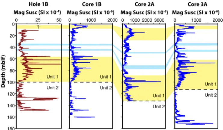
Magnetic susceptibility profiles from Lake Towuti show very similar patterns at all three sites, and show generally ex-cellent correlation to borehole profiles (Fig. 9). These data,
C
la
y
Sil
t
San
d
G
rave
l
Depth (mblf)
0
8 0 2 0
4 0
6 0
1 0 0
1 2 0
1 4 0
1 6 0
1000 2000
Lithology Magnetic Susc.
SI x 10-6
Figure 8.Summary stratigraphy of core TDP-TOW15-3A based on initial core descriptions, and magnetic susceptibility data measured on the whole (unsplit) core from the Geotek MSCL. The key to the lithologic symbols is given in Fig. 6.
0 1000 2000 0 1000 2000 3000 0 1000 2000 Mag Susc (SI x 10-6) Mag Susc (SI x 10-6) Mag Susc (SI x 10-6)
Core 1B Core 2A Core 3A
Unit 1
Unit 2 Unit 1
Unit 2
0 25 50
0
20
40
60
80
100
120
140
160
180
Depth (mblf
)
Mag Susc (SI x 10-4) Hole 1B
Unit 1
Unit 2 ?
Unit 1
Unit 2
Figure 9. Magnetic susceptibility data from borehole logging of Hole 1B as well as MS data of cores 1B, 2A, and 3A. Yellow shading indicates correlative high magnetic susceptibility features in each site, whereas blue shading indicates correlative low sus-ceptibility features. The dashed line marks the interpreted bound-ary between Seismic Unit 1 and 2; note that this boundbound-ary appears younger in core 2A than at sites 1 and 3.
in deeper water than the other sites. This could suggest rel-atively fast subsidence of the northernmost part of the lake relative to the central part of the basin, perhaps reflecting re-cent changes in fault motion.
Our analysis of these cores is just beginning and includes an array of geochronological, sedimentological, geochemi-cal, geophysigeochemi-cal, and biological methods. The
geochronol-ogy is being assembled through a combination of40Ar /39Ar
ages on tephras, paleomagnetic, luminescence, and14C
dat-ing. State of the art isotopic, organic geochemical, and ele-mental methods are being applied to understand the climate history of the tropical western Pacific and the evolving bio-geochemistry of the basin. Analyses of the pore fluid chem-istry, Fe-mineralogy, and microbial communities in the sedi-ments will reveal the nature of the deep biosphere that inhab-its these iron-rich sediments, and fossil pollen and fossil di-atoms will reveal the dynamics of the evolving terrestrial and aquatic biota in central Sulawesi. Ultimately, through inter-actions between these groups we will try to unravel the cou-pled tectonic, biologic, and climatic evolution of this unique system.
7 Data availability
Cores and project data are archived at the National Lacus-trine Core Repository, USA and are under a 2-year mora-torium during which time only project scientists have ac-cess. The data will become publicly available in 2018, but could, through request to LacCore, be made available earlier to other individuals on a case-by-case basis.
Acknowledgements. This research was carried out with partial support from the International Continental Scientific Drilling
Program (ICDP), the U.S. National Science Foundation (NSF), the German Research Foundation (DFG) the Swiss National Science Foundation (SNSF), PT Vale Indonesia, the Ministry of Research, Education, and Higher Technology of Indonesia (RISTEK), Brown University, the GFZ German Research Centre for Geosciences, the Natural Sciences and Engineering Research Council of Canada (NSERC), and Genome British Columbia. We thank PT Vale Indonesia, the US Continental Scientific Drilling and Coordination Office, and US National Lacustrine Core Repository, and DOSECC Exploration Services for logistical support. The research was carried out with permissions from RISTEK, the Ministry of Trade of the Republic of Indonesia, the Natural Resources Conservation Center (BKSDA), and the Government of Luwu Timur of Sulawesi. We thank Andy Cohen and Christine Lane for helpful comments on a previous version of this paper.
Edited by: U. Harms
Reviewed by: A. S. Cohen and C. S. Lane
References
Aldrian, E. and Susanto, R. D.: Identification of three dominant rainfall regions within Indonesia and their relationship to sea sur-face temperature, Int. J. Climatol., 23, 1435–1452, 2003. Cannon, C. H., Morley, R. J., and Bush, A. B. G.: The current
rain-forests of Sundaland are unrepresentative of their biogeographic past and highly vulnerable to disturbance, P. Natl. Acad. Sci. USA, 106, 11188–11193, 2009.
Carolin, S. A., Cobb, K. M., Adkins, J. F., Clark, B., Conroy, J. L., Lejau, S., Malang, J., and Tuen, A. A.: Varied response of western Pacific hydrology to climate forcings over the last glacial period, Science, 340, 1564–1566, 2013.
Chiang, J. C. H.: The tropics in paleoclimate, Annu. Rev. Earth Pl. Sc., 37, 20.21–20.35, 2009.
Clement, A. C., Cane, M. A., and Seager, R.: An orbitally-driven tropical source for abrupt climate change, J. Climate, 14, 2369– 2375, 2001.
Costa, K., Russell, J. M., Vogel, H., and Bijaksana, S.: Hydrologial connectivity and mixing of Lake Towuti, Indonesia in response to paleoclimatic change over the last 60,000 years, Palaeogeogr. Palaeocl., 417, 467–475, 2015.
Crowe, S. A., O’Neill, A. H., Katsev, S., Hehanussa, P. E., Haffner, G. D., Sundby, B., Mucci, A., and Fowle, D. A.: The biogeo-chemistry of tropical lakes: a case study from Lake Matano, In-donesia, Limnol. Oceanogr., 53, 319–331, 2008.
DiNezio, P. N. and Tierney, J. E.: The effect of sea level on glacial Indo-Pacific climate, Nat. Geosci., 6, 485–491, 2013.
DiNezio, P. N., Clement, A. C., Vecchi, G. A., Soden, B. J., Broccoli, A. J., Otto-Bliesner, B., and Braconnot, P.: The re-sponse of the Walker Circulation to LGM forcing: Impilca-tions for detection in proxies, Paleoceanography, 26, PA3217, doi:10.1029/2010PA002083, 2011.
Ehlmann, B. L., Mustard, J. F., Fassett, C. I., Schon, S. C., Head, J. W., DesMarais, D. J., Grant, J. A., Murchie, S. L., and the CRISM team: Clay mineralogy and organic preservation poten-tial of lacustrine sediments from a Martian delta environment, Nature Geoscience, 1, 355–358, 2008.
hydrologic variation in the South American tropics as recon-structed from the Lake Titicaca drilling project, Quaternary Res., 68, 410–420, 2007.
Haffner, G. D., Hehanussa, P. E., and Hartoto, D.: The biology and physical processes of large lakes of Indonesia: Lakes Matano and Towuti, in: The Great Lakes of the World (GLOW): Food-Web, Health, and Integrity: Leiden, edited by: Munawar, M. and Hecky, R. E., The Netherlands, Blackhuys, 129–155, 2001. Hamilton, W.: Tectonics of the Indonesian region, U.S.G.S.
Profes-sional Paper, 1078, 345 pp., 1979.
Hamilton, W. B.: Plate tectonics and island arcs, Geologic Society of America Bulletin, 100, 1503–1327, 1988.
Hendon, H. H.: Indonesian rainfall variability: impacts of ENSO and local air-sea interaction, J. Climate, 16, 1775–1790, 2003. Herder, F., Nolte, A. W., Pfänder, J., Schwarzer, J., Hadiaty, R. K.,
and Schliewen, U. K.: Adaptive radiation and hybridization in Wallace’s dreamponds: evidence from sailfin silversides in the Malili lakes, P. Roy. Soc. Lond. B, 273, 2209–2217, 2006. Hodell, D. A., Anselmetti, F. S., Ariztegui, D., Brenner, M.,
Cur-tis, J. H., Gilli, A., Grzesik, D., Guilderson, T. J., Müller, A. D., Bush, M. B., Correa-Metrio, A., Escobar, J., and Kutterolf, S.: An 85-ka record of climate change in lowland central America, Quaternary Sci. Rev., 27, 1152–1165, 2007.
Kadarusman, A., Miyashita, S., Maruyama, S., Parkinson, C. D., and Ishikawa, A.: Petrology, geochemistry, and paleogeo-graphic reconstruction of the East Sulawesi ophiolite, Indonesia, Tectonophysics, 392, 55–83, 2004.
Konecky, B. L., Russell, J. M., and Bijaksana, S.: Glacial aridity in central Indonesia coeval with intensified monsoon circulation, Earth Planet. Sc. Lett., 437, 15–24, 2016.
Kumar, S., Merwade, V., Kinter, J. L., and Niyogi, D.: Evaluation of temperature and precipitation trends and long-term persistence in CMIP5 Twentieth-Century Climate Simulations, J. Climate, 26, 4168–4185, 2013.
Lehmusluoto, P., Machbub, B., Terangna, N., Rusmiputro, S., Achmad, F., Boer, L., Brahmana, S. S., Priadi, B., Setiadji, B., Sayuman, O., and Margana, A.: National inventory of the ma-jor lakes and reservoirs in Indonesia, General limnology.: FAO-FINNIDA, 1995.
Meckler, A. N., Clarkson, M. O., Cobb, K. M., Sodemann, H., and Adkins, J.: Interglacial hydroclimate in the tropical west Pacific through the late Pleistocene, Science, 336, 1301–1304, 2012. Meehl, G. A., Stocker, T., Collins, W. D., Friedlingstein, P., Gaye,
A. T., Gregory, J. M., Kitoh, A., Knutti, R., Murphy, J. M., Noda, A., Raper, S. C. B., Watterson, I. G., Weaver, A. J., and Zhao, Z.-C.: Global Climate Projections, in: Climate Change 2007: The Physical Science Basis. Contribution of Working Group I to the Fourth Assessment of the Intergovernmental Panel on Climate Change: New York, USA, edited by: Solomon, S., Qin, D., Man-ning, M., Chen, Z., Marquis, M., Averyt, K. B., Tignor, M., and Miller, D. J., Cambridge University Press, 747–845, 2007. Monnier, C., Girardeau, J., Maury, R. C., and Cotten, J.: Back-arc
basin origin for the East Sulawesi ophiolite (eastern Indonesia): Geology, 23, 851–854, 1995.
Pierrehumbert, R. T.: Subtropical water vapor as a mediator of rapid global climate changes, in: Mechanisms of global climate change at millennial time scales, edited by: Clark, P. U., Webb, R. S., and Keigwin, L. D., Geophysical monograph series v. 112, Washing-ton DC, American Geophysical Union, 339–361, 1999.
Pierrehumbert, R. T.: Climate change and the tropical Pacific: the sleeping dragon wakes, P. Natl. Acad. Sci. USA, 97, 1355–1358, 2000.
Poulton, S. W. and Canfield, D. E.: Ferruginous Conditions: A Dominant Feature of the Ocean through Earth’s History, Ele-ments, 7, 107–112, 2011.
Rintelen, T. V., Wilson, A. B., Meyer, A., and Glaubrecht, M.: Es-calation and trophic specialization drive adaptive radiation of viviparous freshwater gastropods in the ancient lakes on Su-lawesi, Indonesia, Proc. Roy. Soc. Lond. B, 271, 2541–2549, 2004.
Rintelen, T. V., Rintelen, K. V., Glaubrecht, M., Schubart, C., and Herder, F.: Aquatic biodiversity hotspots in Wallacea – the species flocks in the ancient lakes of Sulawesi, Indonesia, in: Bi-otic evolution and environmental change in southeast Asia Cam-bridge, edited by: Gower, D. J., Johnson, K. G., Richardson, J. E., Rosen, B. R., Rüber, L., and Williams, S. T., Cambridge Uni-versity Press, 2012.
Russell, J. and Bijaksana, S.: The Towuti Drilling Project: Paleoenvironments, Biological Evolution, and Geomicrobiol-ogy of a Tropical Pacific Lake, Sci. Dril., 14, 68–71, doi:10.2204/iodp.sd.14.11.2012, 2012.
Russell, J. M., Vogel, H., Konecky, B. L., Bijaksana, S., Huang, Y., Melles, M., Wattrus, N., Costa, K., and King, J. W.: Glacial forcing of central Indonesian hydrolclimate since 60,000 yr B.P., P. Natl. Acad. Sci. USA, 111, 5100–5105, 2014.
Scholz, C., Johnson, T. C., Cohen, A. S., King, J. W., Peck, J. A., Overpeck, J. T., Talbot, M. R., Brown, E. T., Kalindekafe, L., Amoako, P. Y. O., Lyons, R. P., Shanahan, T., Castañeda, I. S., Heil, C. W., Forman, S. L., McHargue, L. R., Beuning, K. R. M., Gomez, J., and Pierson, J.: East African megadroughts between 135 and 75 thousand years ago and bearings on early-modern human origins, P. Natl. Acad. Sci. USA, 42, 16416–16421, 2007. Schubart, C. D., Santl, T., and Koller, P.: Mitochondrial patterns of intra- and interspecific differentiation among endemic freshwa-ter crabs of ancient lakes in Sulawesi, Contrib. Zool., 77, 83–90, 2008.
Seager, R. and Battisti, D. S.: Challenges to our understanding of the general circulation: abrupt climate change, in:Global Circulation of the Atmosphere, edited by: Schneider, R. R. and Sobel, A. H., Princeton, Princeton University Press, 331–371, 2007.
Tamuntuan, G., Bijaksana, S., King, J. W., Russell, J. M., Fauzi, U., Maryuanani, K., Aufa, N., and Safiuddin, L. O.: Variation of magnetic properties in sediments from Lake Towuti, Indonesia, and its paleoclimatic significance, Palaeogeogr. Palaeocl., 420, 163–172, 2015.
van Welzen, P. C., Parnell, J. A. N., and Slik, J. W. F.: Wallace’s line and plant distributions: two or three phytogeographical areas and where to group Java?, Biological Journal of the Linnaen Society, 103, 541–545, 2011.
Vogel, H., Russell, J. M., Cahyarini, S. Y., Bijaksana, S., Wattrus, N., Rethemeyer, J., and Melles, M.: Depositional modes and lake-level variability at Lake Towuti, Indonesia during the past
∼29 kyr BP, J. Paleolimnol., 54, 359–377, 2015.