540
SEASONAL FLOW REGIME ON THE RIVERS
FROMăC LIMANIăMOUNTA
INS
HÎRLAV C. 1, PORCUŢAN ADRIANA 2
ABSTRACT. - SeasonalăflowăregimeăonătheăriversăfromăC limaniăMountains. In this study we try to analyze some important hydrometric problems such as the seasonal river flow regime on the rivers from Căliman Mountains, regime types and regime’s space and time variation. The seasonal river flow repartition is
determined by the way all supply sources combine during the entire year. In all seasons it can be observed a strong correlation between flow values and basins’
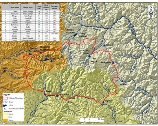
average altitude. This study uses data from 14 hydrometric stations, with rivers
that belong to three different hydrographic basins: Siret River, Mureş River and Someş River. The data series analyzed in this study about river flow regime from the three basins ranges over the period 1950-2010. The availability areas for these
relations reflect precise enough role of the climatic factors in the seasonal flow’s
land repartition. Seasonal average flow maps highlight the contrasts between the characteristic values of the mountainous space.
Key words: regime, season, regime types, variation, trend.
1. INTRODUCTION
The seasonal river flow repartition is determined by the way main supply sources combine during the year. In all seasons it can be observed a strong relation between flow values basin’s average altitude. As a genetic factor, the climate plays an important role in Călimani Mountains’ flow characteristics, but the spatial differences are influenced by other natural factors, such as: orographic, geologic, soils, vegetation, etc.. The most important role in river flow seasonal regime differences is determined by the climate factor, including temperature, rainfalls quantity and snow layer.
The flow repartition during the year determines the waters’ economical values. The more balanced the water flow regime is, the more efficient they can be used. The way main supply sources combine is reflected in the annual flow repartition. In this study about river flow regime we analysed data from 14 hydrometric stations from the study area for the years 1950-2010.
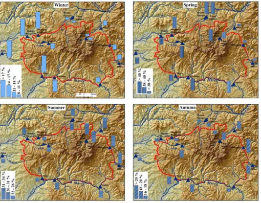
The climatic seasons that influence regime’s phases and spatial water regime repartition are: winter (XII-II), spring (III-V), summer (VI-VIII) and autumn (IX-XI). The percentage flow analysis in all four seasons makes possible the first regime phase analysis and of discharges evolution.
1 „Babeş-Bolyai” University, Faculty of Geography, 400006, Cluj-Napoca, Romania E-mail: [email protected]
541
Fig. 1. Hydrometric stations repartition
2. THE MULTIANNUAL REPARTITION OF SEASONAL FLOW
The unitary data analyse of Călimani Mountains discharges highlights the special quality of this massive to nurture and gather on its rivers high water volume on river basins that are not very extensive. Very relevant for this fact is the evolution of annual average discharge values.
Some strong territorial contrasts an be observed in seasonal flow regime, determined especially by the specific river supply conditions.
This study uses data from 14 hydrometric stations, with rivers that belong to three different hydrographic basins: Siret River, Mureş River and Someş River. To underline the flow regime particularities in three time periods we took into study: (1950-1967, 1950-2010 şi 1970-2010).
542
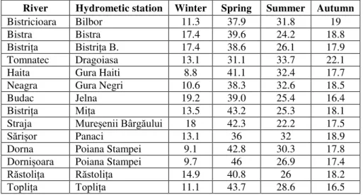
Table 1. Percentage values of seasonal flow (1950-2010)
The smallest percentage values were registrated at Gura Haiti (on Haita River) and Poiana Stampei stations (on Dorna River), both placed on the northern slopes of Călimani Mountains that are caractherised by an anticyclone persistent regime, with low rainfalls values and low temperatures.
Evident differences can be observed in the spatial repartition of the climatic and hydrological factors determined by the air masses circulation and by the relief through slopes exposure. After the percentage flow analyze of rivers in the three hydrographic basins present significant differences between the stations.
Winter (XII - II). The winter territorial flow repartition is influenced
especially by the fallen rainfalls quantities (rarely in liquid estate) and by the thermal regime.
It can be observed that the seasonal flow regional differences are determined by the river basins altitudes and their exposure to western air masses advection. So, the smallest percentage winter flow values (8 – 11% from the annual average volume) are registered on the rivers from the northern slopes of Căliman Mountains (Haita, Dorna, Dornişoara and Neagra rivers). The average altitudes of the basins’ from above are the highest (between 1000 – 1500 m), causing high frequency of negative temperatures, so diminishing possibilities for river alimentation from snow melting. Intermediate values, between 11 and 16% of the annual average volume appear on the eastern and south – eastern slopes (Bistricioara, Tomnatec, Sărişor, Topliţa and Răstoliţa).
The highest winter percentage flow values (above 17%) are registered at the hydrometric stations placed on the western slopes of Căliman Mountains, draining a low altitude mountainous space, with a better exposure to western air masses advection. This causes the snow melting process to start in February, due to higher air temperatures on these slopes.
River Hydrometic station Winter Spring Summer Autumn Bistricioara Bilbor 11.3 37.9 31.8 19 Bistra Bistra 17.4 39.6 24.2 18.8
Bistrița Bistriţa B. 17.4 38.6 26.1 17.9
Tomnatec Dragoiasa 13.1 31.1 33.7 22.1 Haita Gura Haiti 8.8 41.1 32.4 17.7 Neagra Gura Negri 10.6 38.3 32.6 18.5 Budac Jelna 19.2 39.0 25.4 16.4
Bistrița Miţa 13.5 43.2 25.3 18.1
Straja Mureşenii Bârgăului 18 42.3 22.2 17.5
Sări or Panaci 13.1 36 32 18.9
Dorna Poiana Stampei 9.1 42.8 30.3 17.8
Dorni oara Poiana Stampei 9.7 46 26.9 17.4
Răstolița Răstoliţa 14.9 40.8 26 18.2
543
Fig. 2. Seasonal flow regime variation
After analyzing the multiannual winter flow variation, it can be observed that the highest flow values appeared on different years: 1959/1959 on Tomnatec River; 1953/1954 on Răstolița River; 1993/1994 on Bistricioara River. These winters present climatic conditions which favoured river supplying from rainfalls and also from consecutive snow layer melting. The smallest winter flow values appear during the winter 1952/1953, characterized by a persistent anticyclone regime, with small rainfalls quantities and low temperatures, making almost all the water quantity from rivers to be stored in a solid condition.
Spring (III - V). On all rivers, spring represents the season with the highest
flow values, due to snow melting, relatively high rainfalls quantities and to low evapotranspiration values and to low water infiltration into an over saturated soil or partially frozen. After air temperatures become positive, the snow melting phenomenon is reflected into the spring high waters. Depending on the melting rhythm, rainfalls duration and intensity can appear spring floods, generated by snow melting, rainfalls or both.
544
The lowest percentage values, below 38%, are recorded at the stations from Sărişor, Tomnatec and Bistricioara rivers. Explanation of these low seasonal flow values is that these rivers are situated in a depression trough located at an altitude of about 1000 m. On most rivers in the studied region, the highest spring flow occurred in 1970 and 2000.
In summer (VI - VIII), the decrease of rainfalls, the increase of air
temperatures values and the development of vegetation lead to enhanced evapotranspiration. This phenomenon, together with the intensification of infiltration is reflected in a significant decrease in flow compared to the previous season. The emergence of low summer waters also contributes to the reduction of groundwater supply. Summer floods are triggered by convective rains, rarely frontal, which sometimes can reach very high amplitudes and cause flooding as those of June 1970, June 1974, and July 1980 etc.
During summer time, 22.3% of the annual average discharge on the Straja River at Muresenii Bârgăului Station, and 33.7% on Tomnatec River at Drăgoiasa Station. The flow is considerably reduced (24-30%) in comparison with the above season and is explained by the relatively small quantities of liquid rainfalls and by the more rapid depletion of snow supplies than the spring high waters
The highest summer percentage values (31-34 %), closed to those from spring, appear on the western slopes of the Căliman Mountains.
The smallest summer flow values appeared at Miţa, Bistriţa Bârgăului and Mureşenii Bârgăului stations.
Autumn (IX - XI). In this season, the evaporation decreases and autumn
rainfalls appear, and the underground supplies are depleted and very low. Over the autumn end can appear floods generated by high, persistent rainfalls.
Together with winter, autumn is one of the seasons with the lowest contribution to the annual average water volume (16 – 22%), even though the values twice highest than those during winter time. Some evident contrasts can be observed during autumn flow, caused by many climatic factors.
545
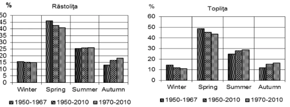
After analyzing the percentage flow contribution to annual average water volume in the three analyzed periods, it can be observed that between 1970 – 2010 the winter flow values decreased and autumn values increased (Figure 3). The spring percentage flow values remained very similar.
3. CONCLUSIONS
After data analyze and correlation using percentage values of the seasonal flow and the average altitude of the rivers basins, it can be observed that there exists a close relation between the river water regime from Căliman Mountains and the climatic factors, with some local differences.
The analyze of seasonal and monthly flow regime shows that the western part of the Căliman Mountains is situated into the Transylvanian Carpathic regime type and the eastern part of the Căliman Mountains is situated into Eastern Transylvanian Carpathic regime type.
The availability areas of these relations reflect the important role of climatic factors in seasonal flow territorial repartition. It also can be observed a significant difference of the seasonal flow regime between the three hydrographic basins.
The highest flow percentages appear in spring time, due to snow melting, positive temperatures, low evaporation, rainfall showers, which can determine the apparition of floods.
Acknowledgements
This paper is a result of a research made possible by the financial support of the Sectoral Operational Program for Human Resources Development 2007-2013, co-financed by the European Social Fund, under the project POSDRU/159/1.5/S/132400 - “Young successful researchers – professional development in an international and interdisciplinary environment”.
REFERENCES
1. Dincă, I., (2004), Apa și peisajele din Munții Călimani, Edit. Universității, Oradea.
2. Sorocovschi, V., (2009), Hidrologia uscatului, Edit. Casa Cărți de tiință, Cluj -Napoca.
3. Sorocovschi, V., Cocuţ, M. (2008), Regimul scurgerii apei râurilor din Depresiunea Maramureşului şi spaţiul montan limitrof, Geographia Napocensis,
an.II, 2, Edit. Casa Cărţii de Ştiinţă, Cluj-Napoca.
4. Şerban, G., Bătinaş, R. (2005), Noţiuni practice de hidrologie generală -Partea I, Hidrogeologie, Potamologie, Edit. Casa Cărţii de Ştiinţă, Cluj-Napoca.
5. Újvari, I. (1959), Hidrografia R. P. Române, Edit. Ştiinţifică, Bucureşti.
6. Újvari, I. (1972), Geografia apelor României, Edit. Ştiinţifică, Bucureşti.