www.hydrol-earth-syst-sci.net/18/927/2014/ doi:10.5194/hess-18-927-2014
© Author(s) 2014. CC Attribution 3.0 License.
Hydrology and
Earth System
Sciences
Acting, predicting and intervening in a socio-hydrological world
S. N. Lane
Institute of Earth Surface Dynamics, Faculté des géosciences et de l’environnement, Université de Lausanne, Lausanne, Switzerland
Correspondence to:S. N. Lane (stuart.lane@unil.ch)
Received: 29 July 2013 – Published in Hydrol. Earth Syst. Sci. Discuss.: 16 August 2013 Revised: 15 January 2014 – Accepted: 26 January 2014 – Published: 7 March 2014
Abstract.This paper asks a simple question: if humans and their actions co-evolve with hydrological systems (Sivapalan et al., 2012), what is the role of hydrological scientists, who are also humans, within this system? To put it more di-rectly, as traditionally there is a supposed separation of sci-entists and society, can we maintain this separation as socio-hydrologists studying a socio-hydrological world? This pa-per argues that we cannot, using four linked sections. The first section draws directly upon the concern of science-technology studies to make a case to the (socio-hydrological) community that we need to be sensitive to constructivist ac-counts of science in general and socio-hydrology in partic-ular. I review three positions taken by such accounts and apply them to hydrological science, supported with specific examples: (a) the ways in which scientific activities frame socio-hydrological research, such that at least some of the knowledge that we obtain is constructed by precisely what we do; (b) the need to attend to how socio-hydrological knowledge is used in decision-making, as evidence suggests that hydrological knowledge does not flow simply from sci-ence into policy; and (c) the observation that those who do not normally label themselves as socio-hydrologists may ac-tually have a profound knowledge of socio-hydrology. The second section provides an empirical basis for considering these three issues by detailing the history of the practice of roughness parameterisation, using parameters like Man-ning’s n, in hydrological and hydraulic models for flood inundation mapping. This history sustains the third section that is a more general consideration of one type of socio-hydrological practice: predictive modelling. I show that as part of a socio-hydrological analysis, hydrological predic-tion needs to be thought through much more carefully: not only because hydrological prediction exists to help inform decisions that are made about water management; but also
1 Introduction
“No one sees the earth globally and no one sees an ecological system from nowhere, the scientist no more than the citizen, the farmer or the ecologist – or, lest we forget, the earthworm. Nature is no longer what is embraced from a far away point of view where the observer could ideally jump to see things “as a whole”, but the assemblage of contradictory entities that have to be composed together.” (B. Latour, 2011)
The thesis of this paper welcomes the potential of socio-hydrology (after Sivapalan et al., 2012) as part of a new decade of hydrological activity concerned with prediction under change. However it argues that, if we live and work within landscapes where society and water have both co-evolved and are intimately connected, how we predict water within those landscapes must also be considered as a socio-hydrological problem.
To introduce my argument, I start with a quote from Sivapalan et al. (2011) concerned with the challenge of socio-hydrology: “Explicitly confronting hydrological prediction with human behaviour poses challenges in the description and quantification of hydrological systems in termsthat are meaningful in economic or policy frameworks. . . Given the multiple scales, multiple decision-makers and multiple pro-cesses that drive the evolution of coupled human and water systems, they pose enormous challenges for prediction over long time scales.” (p. 8, my emphasis in italic)
This quote is instrumental for this paper because it em-phasises that hydrological science, and especially socio-hydrological science, is a science that actively matters: whether through securing the safe supply of clean water, sustaining vital ecosystem services or defining strategies to avoid our exposure to extreme hydrological events, it is a sci-ence intimately bound with society and its needs. Yet it also emphasises that socio-hydrology is a science that is shaped by economic and/or policy frameworks. Such shaping arises for two reasons:
1. prediction of the future is not an open-ended process; rather it requires a series of important assumptions to be made about what should be included in the predic-tive model used, which elements are to be left station-ary and which are to be left dynamic, etc. (Lane et al., 2011a), effectively a series of acts of framing by the scientists involved; and
2. becausesocialfutures are not well defined in a socio-hydrological world, this framing is as much about statements about what the social could be, even should be. That is, whilst framing of futures may have a sci-entific basis (e.g. in future rainfall predictions), in a socio-hydrological world there will be many other el-ements to this framing over which a hydrological sci-entist cannot claim a particular privilege.
Socio-hydrology clearly represents an exciting opportu-nity, as it offers the potential for a series of innovative
collaborations between hydrological scientists and social scientists to develop new ways of understanding socio-hydrological systems and perhaps to develop new predictive approaches. There is also a debate to be had over precisely what the hydrological contribution might be to understand-ing in socio-hydrology, given that social scientists have been studying the co-evolution of social and hydrological systems for very many years (see the classic text by Wittfogel (1957), for example). This paper does not address this debate. Rather, it looks critically at the notion of socio-hydrology through a different perspective, that provided by science technol-ogy studies (STS), and in so doing, it argues, for hydro-logical scientists who might be interested in working in a socio-hydrological framework, that socio-hydrological prac-tice will need much more than the “bolting on” of social sci-ence questions to hydrological scisci-ence questions. It will re-quire a wholesale rethink of how we practise hydrological science within a socio-hydrological project.
STS provide a theoretical framework for this rethinking. The last few decades have seen the development of what has been called a “sociological turn” in studies of science (Collins and Evans, 2002). The essence of this turn has been a shift away from debates over the ideal form that science should take so as to guarantee that scientists have special ac-cess to the truth. The new focus has been upon how science is practised and what this means for the position of science in society, such as in making decisions. As I review below, this has revealed that
1. science as practised (e.g. the conduct of a research project) is not necessarily the same as science as it is portrayed (e.g. in the structure of a scientific article) and how science is practised shapes fundamentally the scientific knowledge that is generated;
2. policy-making is not simply based upon the results of scientific enquiry; and
3. “scientists” are not the only individuals within society that have scientific expertise; rather, scientific knowl-edge is more widely distributed amongst those who have a particular experience or interest of the problems that commonly interest scientists.
what Collins and Evans argue that it should be, was norma-tive, that is, prescriptive of how scienceshouldbe practised given what the constructivist account showed. Without what Collins and Evans describe as a “third wave”, there is a risk of rejection of scientific knowledge as a critical contributor to the difficult decisions that have to be made in an era of potential environmental crisis (see also Demeritt, 2006). A third wave of science studies is needed that prescribes how best to sustain the contribution that science has to make to societal decision-making.
The primary aim of this paper is to think through the possible contribution of hydrological science to understand-ing, and perhaps predictunderstand-ing, a socio-hydrological world. First (Sect. 2), I begin by illustrating, using hydrological exam-ples, the three points above, so as to consider how predictive socio-hydrological scienceshould be practised to establish its legitimate contribution to policy- and/or decision-making. At the start of a new decade of hydrological science con-cerned with prediction, we have a profound opportunity to do this. The second (Sect. 3) provides an empirical example of the construction of hydrological knowledge in practice, by detailing the history of roughness parameterisation, using parameters like Manning’sn, in hydrological and hydraulic models. As a third point (Sect. 4), I use this example to show why we need a “third wave” of science studies if the evolv-ing discipline of socio-hydrology is to fulfil its potential, that is, we need to rethink the traditional view of the relation-ship between hydrological expertise and society. Fourthly, in Sect. 5, I introduce a set of principles that might contribute to such a rethinking and illustrate their implementation through a specific case example. The paper contains a mixture of re-view as well as primary evidence, the latter obtained from a project concerned with new forms of participation in flood risk management (Lane et al., 2011b).
2 A constructivist account of hydrological practice
In this first section, I draw directly upon science-technology studies to introduce to hydrologists the case for a construc-tivist account of science in general and hydrology in partic-ular. At the outset, this engages with a set of literature that will not be familiar to the hydrological scientist, but which is important because it shows that the constructivist account is one that parodies elements of conventional scientific method in general, and our practices as hydrologists in particular: that is, it is based upon empirical observation of science in practice, in the same ways in which a hydrological scientist might focus upon, for example, the observation of river flow. Whereas the subject of hydrology tends to be “things to do with water”, the subject of STS as considered in this paper is “hydrological science and how it is practised”. I make three points. The first draws upon work done largely in the science-technology studies community, which includes philosophers, sociologists, historians and geographers amongst others, that
has sought to understand how scientists construct knowledge about the natural world. The work has shown that rather than scientific activity simply finding out about the real world, sci-ence as a practice involves defining what that world is, as we come to know it. The second considers evidence of how hydrological knowledge is used in decision-making, which questions the traditional assumption that such knowledge can be a simple basis of informing difficult policy decisions. The third demonstrates the deep and sometimes profound knowl-edge of hydrological science that those often labelled as “lay people” may have, and which suggests that there is a much broader community of potential hydrological scientists who have to be considered in a socio-hydrological account. Each of the three accounts is well developed in science-technology studies (STS) in general, and so the review is brief. As my examples will show, hydrology has generally escaped such analysis as compared with environmental concerns (e.g. cli-mate change; genetically modified organisms and the food chain; nuclear power) that share the similar challenges of un-derstanding complex, open systems (Wiman, 1991).
2.1 Framing and the construction of scientific knowledge
constructivist accounts in that, in a way that parodies the traditional activities of field hydrological scientists, they are based upon explicit observation of science in practice.
One of the first attempts to reveal science as practised is found in the book by Latour and Woolgar (1979),Laboratory Life: The Social Construction of Scientific Facts. Latour and Woolgar argue that a focus on practice is necessary because the publication of “systematic and tidied research reports” (p. 29) does not illuminate the realities by which knowledge comes about, and hence precisely what the status of scientific knowledge is. Through an anthropological study of medical scientist Roger Guillemin’s medical laboratory at the Salk In-stitute, California, Latour and Woolgar make four (amongst other) important observations. First, they showed that the ma-terial, technical and human resources of the laboratory de-termined the challenges afforded in practising science and the facts that were found, whether through the logic of de-ductive reasoning or the observations behind inde-ductive rea-soning. There was clearly an act of framing of knowledge by the resources assembled in the laboratory. Second, they considered what constitutes facts in a laboratory setting and they noted that in scientific papers produced by the labora-tory, it was possible to identify a “continuum of facticity” (p. 76) between those statements that could be taken as given (facts) and those that were speculative. The work of the lab-oratory was to move statements from speculation to given. Third, they observed that “reality” and “fact” was not nec-essarily the same thing. There were statements used in the laboratory that were “considered too costly to modify” and that these “constitute what is referred to as reality” (p. 243) in the laboratory, regardless of their status as facts. I will il-lustrate this point with respect to the widely used roughness parameter, Manning’sn(in Sect. 3). Fourth, they showed that facts emerge in networks of scientists (and the things that they study) and that it is these networks that give facts their meaning. Without the network, the meaning of a fact may evolve or even take on a new form: the networks produce this meaning; and the meaning only survives as long as the network can maintain it.
The key implication that arises from these four points is that the claim to scientific authority that arises from pursuit of a rigorous scientific method, one reproduced in the pages of scientific papers and reports, cannot be sustained. Scien-tific papers are, at once, both a valuable outcome of scienScien-tific activity (new scientific knowledge) but also a misrepresen-tation of how that knowledge is produced in practice. The Latour and Woolgar (1979) study stimulated both: debate over method (e.g. Lynch, 1982) and substance (e.g. Tilley, 1981; Stewart, 1982) but also a wave of similar studies of scientific practice (e.g. Shackley et al., 1999 in relation to climate change); and an extension to consider technology, the latter showing that the same argument developed for a sociology of scientific knowledge could equally be used in a sociology of technological innovation (e.g. chapters in Bijker et al., 1987).
There is now a set of studies in the environmental sciences, still relatively small, that have sought to develop Latour and Woolgar’s ideas so as to understand how environmental knowledge is produced, both in general, and with reference to environmental prediction in particular (e.g. Shackley et al., 1999; Lahsen, 2005; Demeritt, 2006; Sundberg, 2009; Brysse et al., 2013). Latour, who remains one of the key researchers in this field, also came close to the domain of hydrology when he joined a scientific expedition to the Amazon con-cerned with understanding the dynamics of tropical rain for-est expansion and contraction at its margins with savannah: where is the boundary and how is it moving (Latour, 1999a)? Latour’s (1999a) work provides some key ideas here for how hydrology is practised, that are expanded on in Sect. 3. La-tour describes how a how a botanist, a soil scientist and a geomorphologist tease out, selectively and in a single geo-graphical location, a set of relationships from an environ-ment that at first glance appears to be disorganised and be-yond explanation, not unlike classic challenges in field hy-drological science (e.g. complex space–time patterns of soil moisture distribution). Latour notes that each scientist brings to the research process particular kinds of “inscription de-vices”, those are objects (e.g. equipment, measurement pro-tocols) that make the field site measurable according to the wider approaches and presumptions associated with each sci-entist’s discipline. The devices (e.g. a standardised soil ten-siometer) are critical, as they homogenise the study of very different field environments, making them comparable both to one another and to the academic world of that discipline. The field site can be made knowable on the basis of each dis-cipline’s dominant terms of reference: the “référence circu-lante”. To arrive at this point, the complexity of the real world is progressively reduced (as it is in the laboratory) through a series of steps of “translation” so as to lose its local focus and to amplify its general representativeness and eventually to allow it to be written in a form typical of a “scientific” document such as a research paper. Latour (1999a) argues that understanding what is being done here requires both a realist and a relativist perspective, realist because scientific activityisconstrained by the real world (Gooding, 1990) and these constraints survive through the translation; but relative because, unavoidably, what we know about the real world is constructed, or framed, through the process of translation, that is, science as practised.
the findings of hydrological activity are framed by the deci-sions that hydrologists make and, through this framing, par-ticular accounts of the hydrological world become dominant over others. It implies a need for empirical observation of hydrology in practice, something that is illustrated in Sect. 3. 2.2 Science in decision-making
The second element of the constructivist account of edge is concerned with observations of how scientific knowl-edge translates into making. Here, I define decision-making broadly, to relate to those situations where there is some kind of translation of scientific knowledge into deci-sions that have to be made to develop or to modify policy, as well as in relation to more specific cases, where a par-ticular scientific finding is used to inform a parpar-ticular man-agement intervention. As with previous sections concerned with scientific practice, this second element has also been strongly empirical (see for example, Wynne, 1992; Demeritt, 2001, 2006; Bickerstaff and Simmons, 2004; Pielke, 2007; Liken, 2010; Oreskes and Conway, 2010), that is, the re-lationship between science and decision-making has been traced historically and used to challenge the simple assump-tion that scientific knowledge translates simply, or “linearly” into decision-making, the “linear model”. Under this head-ing, there are three broad elements of critique (Beck, 2011): (1) that science produces certainty by reducing uncertainty, and so can aid the taking of difficult decisions; (2) that sci-entific knowledge can be a basis of resolving political dis-cord; and (3) that through the exclusion of politics from sci-ence, scientific knowledge becomes a more rational basis for decision-making than other kinds of knowledge.
2.2.1 Science and the assumption that scientific research reduces uncertainty
Wynne (1992) provides what has become a classic analysis of uncertainty surrounding science. He argues (see also Beven, 2008) that uncertainty should be unpacked into a typology of 1. risk (the quantifiable probability of an event happen-ing), elsewhere known as aleatory or stochastic uncer-tainty, but that can be quantified;
2. (true) uncertainty (known but unquantifiable probabil-ities), again that may be aleatory or stochastic, but where the uncertainty cannot be quantified;
3. ignorance (the not yet known but potentially know-able, often described as “we don’t know what we don’t know”), also known as epistemic uncertainty; and 4. indeterminacy (that which cannot be known),
some-times also referred to as Knightian uncertainty. Wynne (1992) argues science may contribute to the quan-tification of risk (Type 1) and the analysis of uncertainty
(Type 2) in ways that make it better known. Yet ignorance or epistemic uncertainty is endemic, not least because science is actively involved in creating products and processes whose effects may not be knowable before their creation (e.g. ge-netically modified crops). Indeterminacy questions the very ability to analyse and to predict certain things, notably at the interface with the social world.
Wynne illustrates this typology by tracing the re-lationship between science and decision-making post-Chernobyl (1986) radio caesium fall-out and its impact upon upland soils in the UK. Scientists initially thought that the radio caesium would be rapidly immobilised on the basis of previous experimental testing. Still it was not, because the soils exposed to the heaviest fall out were acidic, whereas the experimental soils were alkaline. The experimental re-sults did not translate completely beyond the experimental case. The initial failure of scientists to conclude that the ra-dio caesium would remain mobile was a classic example of scientific progress: a basic theory based upon prior standing proved to be incorrect, and so new scientific under-standing was obtained.
The progress of learning through mistakes, described above, might be used to conclude that science has re-duced uncertainty, but three points challenge the notion that science can aid difficult decision-making by reduc-ing uncertainty. First, it is well-established that science ad-vances through a process of examination, revision and re-examination (Oreskes, 2004), a process in which scientific progress is most rapid when existing knowledge claims are no longer found to hold. If science proceeds through falsi-fication, and this falsification happens publically, then the claimed authority of science may become questioned in a very public way. Wynne (1992) reports exactly how this hap-pened amongst local communities in his study when radio caesium was not rapidly immobilised, and wider concerns emerged regarding the general authority of scientists regard-ing the safety of Sellafield, the adjacent nuclear waste pro-cessing plant. The same occurs with flood risk maps that are generally right in that they can achieve inundation patterns that are 80 to 90 % accurate (e.g. Yu and Lane, 2006) but wrong in the detail that matters in relation to those who live with flood risk (the remaining 10 to 20 %) as well as ineffec-tive in scientific terms, as a means of enabling model calibra-tion (Stephens et al., 2012). Thus, such maps can be the ori-gin of significant hydrological controversy both within and beyond scientific communities (Lane, 2013). If the nature of science is to proceed through showing elements of scientific knowledge to be incorrect, then this implies the translation of supposed certainties into supposed uncertainties which in turn motivates new scientific enquiry. Science proceeds by producing uncertainty and not certainty.
contingent conditions may significantly shape environmental response (e.g. Wiman, 1991; Trudgill and Richards, 1997), as with Wynne’s example. The environment has a complexity that commonly places research far from the closed world of the laboratory (Irwin, 2001). The certainty that results, then, is largely conditioned upon the assumptions needed to re-alise said certainty, and I consider this issue in relation to predictive modelling below. Alongside scientific certainty is the production of a series of epistemic uncertainties associ-ated with the need to make that science certain; yet, vagaries of the environment serve to make scientific knowledge inher-ently uncertain.
Third, evidence shows that when policy is faced with new scientific findings, that policy can remain relatively stable, because it is sustained by and in turn sustains a suite of other issues which constrain the extent to which new scien-tific knowledge can be translated into policy. That is, even if the above two concerns regarding scientific uncertainty can be overcome, the scope of scientific enquiry rarely extends to the full range of constraints that may make a particular deci-sion more or less acceptable. For instance, Lane et al. (2011a) considered the history of the 20 % uplift in peak flow mag-nitudes that flood risk modellers were expected to use in England and Wales up until recently to account for possible future climate change. They show that new work that chal-lenged the UK-wide application of this uplift (for catchments of different scales in different geographical regions) failed to change an established policy. The reasons invoked for this were largely related to a societal decision about the need to be conservative regarding safety in relation to climate change impacts and neither the scientific findings nor the associated uncertainties themselves.
In summary, this sub-section shows that we cannot as-sume that science produces simple certainties by reducing uncertainty: science proceeds by discovering its own uncer-tainties; in environmental systems, it commonly relies on as-sumptions that will produce epistemic uncertainty and that, even if these concerns can be resolved, scientific knowledge is rarely the only information that informs policy-making. The latter point leads directly into the observation that sci-ence cannot be assumed to be a sufficient basis for resolving political discord.
2.2.2 Science and the resolution of political discord
It is commonly assumed in the linear model of science into decision-making that science is a means of resolving politi-cal discord. The assumption here is that faced with difficult decisions, science can provide an objective guide to what de-cisions need to be taken. A number of explicitly hydrological examples regarding conflicts over water have challenged this view (e.g. Kropp, 2005; Wesselink et al., 2009; Weber et al., 2011; Austin et al., 2012; Smith et al., 2012). For instance, Kropp (2005) describes the debate over renewal of water li-cense abstractions for hydroelectric power exploitation in the
River Isar, Germany. This was initially a tri-partite debate between the hydropower company, state authorities and the Isar Alliance, a network of conservation interests, environ-mentalists, political parties etc. Debate between them was unable to agree on a way forward and so aRestwasserstudie
was commissioned (a “remaining water study”). This report created more and not less controversy regarding for example water quality standards and the objectives of water conser-vation, causing Kropp to conclude (2005, p. 490) that “once again, the modern hope of depoliticising a conflict through the involvement of scientists and expertise, that is, negotia-tions of facts instead of values, proved vain.” Kropp’s study illustrates clearly the point that even with scientific knowl-edge there are steps in the translation of this knowlknowl-edge into decisions that are negotiated and are concerned with values. In turn, this causes us to question the assumption that science alone can provide a rational basis for decision-making, that is, it is necessary but not sufficient.
2.2.3 The rational basis of science
It is often argued that for science to provide a rational basis for making decisions, the scientist must exclude the context, their values, interests and beliefs, within which they perform their research. This can be a challenge, especially when sci-entists are working in highly visible research areas and are increasingly required to frame their research in terms of ben-efits to society. Evidence also suggests that the goal of trying to do this can actively shape scientific outcomes: not only is it hard to be rational in relation to highly emotive research questions, but the act of trying to be so changes what scien-tific knowledge is generated. In relation to climate change, for instance, Wynne (2010) and Brysse et al. (2013) have shown that through attempts to be objective, rational and sceptical, climate scientists have tended to err on the side of less rather than more alarmist predictions of future climate. Wynne (2010) argues that a series of “cultural-economic ha-bituated practices and global economic relations” (p. 299) has caused climate change scientists to focus upon future mean climate change (e.g. temperature rise) rather than the more alarming and more certain climate extremes: “only ‘digestible’ and (thought-to-be) ‘manageable’ future climate changes are recognised as scientifically accredited” (p. 297) and therefore worthy of scientific investigation.
because they are “scientific”, when they obscure a series of deeper social and economic assumptions, which are rarely exposed in the maps themselves, assumptions that are neces-sary to make the maps. To summarise, as Irwin (2001, p. 74) notes “. . . the “facts” of environmental matters do not speak for themselves: instead they are actively created and inter-preted. Similarly, nature can no longer be represented as an external category. Statements about the natural world repre-sent social and institutional constructions.”
2.2.4 The co-evolution of science with policy
Concerns over the supposed certainty of scientific knowl-edge, evidence that science is not sufficient in resolving po-litical discord, and questions over the extent to which scien-tific knowledge can be a rational basis for decision-making suggest that science does not flow linearly or simply into decision-making as might be assumed. To replace the lear model, it is appropriate to see science and society, in-cluding decision-making, as in a state of co-evolution, with one impacting the other. This ties directly into the notion of socio-hydrology, with its emphasis upon the co-evolution of water with society but suggests that hydrological scientists cannot claim to be separate from this system: the practice of hydrological science, in a socio-hydrological framework, is both constrained and enabled by the socio-hydrological sys-tem within which it is practised, and the syssys-tem will evolve in response to the practice of hydrological science as part of an evolving process of social change.
If this is the case, then we might expect there to be at least some geographical differentiation in the scientific and technical cultures that arise surrounding water: that is, the production of distinctive socio-hydrological systems each on their own path trajectory, as they evolve. Such differentiation was demonstrated in a series of articles by Bijker (2007a, b). He poses a simple question: “How is it possible that the USA failed to keep New Orleans dry, when large parts of the Netherlands can exist below sea level?” His argument is that, of course, there are differences in the geographical and geological setting of the two countries (the Netherlands is a more “watery country” than the USA, in Bijker’s terms). He shows however that such a conclusion is insufficient, not least because the science of land–ocean reactions does, in theory, follow a near-universal set of process laws. Yet, he argues that both countries have evolved completely different socio-hydrological systems, ones that shape exactly how sci-entific and engineering understanding is translated into wa-ter management. For instance, the Dutch have evolved a sys-tem of highly centralised action, built upon the collaboration necessary under penalty of being flooded but also the wider belief in the malleability of society through state action. In turn, this has defined the scientific priorities of Dutch water management and produced a series of approaches to water management that have sustained strong state action. Rather than science flowing linearly into the shaping of particular
technological cultures and policy decisions, science and tech-nology have mutually co-evolved to create very different technological and policy settings. These contain a certain amount of resistance to change, e.g. in response to scientific development, because of the extent to which they are strongly inter-related. Understanding how socio-hydrological systems are made requires us to look carefully at not just how hydro-logical science is practised, as Sect. 2.1 suggests, but also at how (hydrological) scientific practices have evolved within socio-hydrological systems, in ways that are mutually con-stitutive of those systems.
2.3 Certified and non-certified hydrological experts
The third direction in a constructivist account of hydrolog-ical practice recognises that expertise in hydrologhydrolog-ical pro-cesses and systems is much more distributed than might be thought. In any area of science that is strongly bound with society (e.g. hydrological science) then problems will arise if scientific knowledge (and its emphasis upon impersonal ob-servation) becomes detached from meaning (and its embed-ded experience) (Jasanoff, 2010). Jasanoff (see also Wynne, 2010) takes the example of climate change, where the work of the Intergovernmental Panel for Climate Change success-fully established climate change as a global problem but in doing so they distanced climate change from its embed-ded experience, thus undermining those social institutions and ethical commitments that rely upon “the subjective, sit-uated and normative imaginations of human actors engag-ing with nature” (p. 235). Jasanoff argues that it is precisely these social institutions and ethical commitments that need to evolve if there is to be a sufficient response to the challenges posed by climate change. There are two distinctive interpre-tations here: (1) those who live with environmental concerns may hold substantial knowledge of those concerns, acquired through experience, that is in some senses no different from the ways in which scientists might obtain that knowledge; and (2) those institutions and commitments that we will rely upon to manage those concerns are sustained by more than just the knowledge that science can provide.
2.3.1 The distribution of hydrological expertise
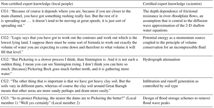
Table 1.A comparison of non-certified expert knowledge, as recorded during an experiment in public participation in flood risk management (Lane et al., 2011b), with the equivalent description that a certified expert (a scientist) might make of the same phenomenon. CG stands for “Competency Group” (see below) and the number refers to the meeting number.
Non-certified expert knowledge (local people) Certified expert knowledge (scientist)
CG1: “Because of course it depends where you are, because if you are closer to the The depth dependence of frictional main channel, you have got something rushing really fast. But the rest of it resistance in river–floodplain flows, an is spreading out . . . it doesn’t tend to be moving at great speeds, it is just sort of assumption that is central to the diffusion spreading out.” wave approximation of the 2-D shallow
water equations
CG2: “Logic says that you have got to work out the contours and work out which is the Potential energy as a momentum source lowest lying land. I suppose there must be some sort of formula to work out exactly the coupled to the principle of volume volume of water you are expecting to come down and therefore to what volume it will conservation for an incompressible fluid fill that level.”
CG2: “But Pickering is a slower process I think, than Sinnington is. And it is not such a Hydrograph attenuation sudden thing. I mean you can see Sinnington rising. I don’t think you can here so
much. [because] Pickering Beck goes much further north, and it is gathering more water.”
CG2: “The other thing that is important is that we have got heavy clay soil. But the Infiltration and runoff generation as soils vary in different parts, whereas of course the clay soil around Great Barugh controlled by soil type
means that other areas are more sandy perhaps and drain more easily.”
CG3: “So to protect Pickering, the nearer the dams are to Pickering the better?” (Local Design of flood storage schemes to remove member 1) “Well yes certainly” (Local member 2) flood wave peaks
public. The second is to ensure the timely and appropriate communication to the public of results if such communica-tion is in the public interest” (Royal Society, 2006, p. 5).
Callon (1999) argues that the “public education model” re-lies upon intermediaries (e.g. public authorities) that are the contact points between scientists and the public and that it can only succeed when these contact points are based upon relations of trust. Problems arise when such notions of trust become damaged and a major reason for such damage is that through their day-to-day experience of nature, quite substan-tial expertise may develop: most publics have elements of expertise because they possess “specific, particular and con-crete knowledge and competencies, the fruit of their experi-ence and observations” (Callon, 1999, p. 85). As the knowl-edge that science can deliver about the real world is in-evitably incomplete (see, for example, Wynne, 1992 and the example of flood risk maps described above), it is always at risk of becoming contested when it is confronted by pub-lic expertise in particular situations. Empirical evidence sug-gests that such expertise is much more broadly distributed than has hitherto been thought (e.g. Wynne, 1992; Darier et al., 1999), prompting some (e.g. Collins and Evans, 2002) to make the distinction between certified knowledge (that of scientists, policy-makers etc.) and non-certified knowledge (that of publics). The notion of certification implies a transfer of legitimacy and hence a privileged position of some kinds of knowledge over others.
The existence of non-certified hydrological knowledge has been shown in a number of studies. In general, river basin management has been an area of experimentation with re-spect to new forms of public participation (e.g. Johnson, 2009). In a project concerned with new forms of public par-ticipation in flood risk modelling, Lane et al. (2011b) were able to show that local flood victims had developed a rich un-derstanding of the fundamentals of hydrology and hydraulics (Table 1) and that this was much more than just “local” knowledge (e.g. Callon, 1999): it was universal in the sense that it referred to generic processes. Through interviews with the participants, Lane et al. (2011b) also showed that this knowledge had not come from formal training, nor was it ac-quired from a singular local place where flooding had been experienced. Rather, it was the accumulation of sometimes many decades of living with water, a process of accumulating knowledge through experience, not dissimilar to the scientist who progressively accumulates knowledge through both for-mal training and the practice of researching hydrology.
and biased manner. For Callon, it is a question of framing. Scientific activity is concerned with the transformation of the real world into objects (e.g. a hydrological model or flood inundation maps) that can be used to generate knowledge. Strictly, the knowledge that we acquire is about the assump-tions made in the framing, as I discuss in Sect. 2.1, and not necessarily the world itself, although we may embark upon a series of measures to make sure that the framing conforms with the real world (e.g. its validation) or, if not, to force the framing to conform with the real world (its calibration). These framings are produced by our own experience (that is, they have a history), our position with respect to other framings and they evolve through our scientific practices and hence define our futures as scientists (see also Lane, 2012).
Callon’s (2005) point is that we are often disabled in the evaluation of our own framing because we are locked into it, something that has been confirmed by empirical research. For instance, Lahsen (2005) showed how climate modellers were often ineffective at identifying flaws within their own models. In one sense, such identification may be achieved through effective peer review processes, but when whole sci-entific communities are locked into particular practices, even those processes may not be effective. Smith et al. (2012) show how flood maps may become objects that serve to legit-imise the exclusion of wider debate between those implicated in decisions to which those maps refer. In Callon’s terms, the maps may become disabling devices. It is for this reason that Callon (2005) advocates greater rather than less public in-volvement in scientific practice because, for the public: “It is their initial ignorance that enables them to dare to explore new paths and to develop original competencies. Democracy is therefore entirely an affair whose success depends on the engagement of disabled persons. This engagement protects the issue from the risk of being hijacked . . . by elites with no ambition other than putting it at the service of their own interests” (p. 313).
2.3.2 Embedding knowledge and the translation of science into policy
A failure to recognise Callon’s observation is not simply a question of democracy but also one regarding the effective translation of science into policy. Here, I argue that it is not just a question of recognising the distribution of scien-tific knowledge but also that the meaning of that knowledge comes only from the way in which it is embedded within the lives that hold it. For instance, particular scientific fram-ings often imply certain expectations of people, that they have the necessary “capital” (social, economic, cultural) to cope with its expectations. In flood risk mapping and hy-drological forecasting, the classic example is that those at risk from extreme flood events will have the capacity both to prepare themselves for future flooding and to act when a particular warning is issued. Research has shown that this is anything but the case (e.g. Mustafa, 2005); not that the
associated hydrological science is wrong, nor that flooding is not a potential risk, but rather that it is not a risk that can be rationalised and acted upon when faced with a series of much more serious and pressing risks. The implicit adoption of par-ticular framings of a problem and their imposition upon the public may then undermine the very real risks that the pub-lic itself faces (e.g. Wynne, 2010). As Bijker (2004, p. 381) notes, then, the merit of science “is accomplished in social practice and not bestowed upon science by philosophers or others.” The argument here is that not only should the ba-sis of scientific knowledge be more distributed but also that scientific knowledge only has meaning within those com-munities who have to live with its consequences. If a disci-pline like socio-hydrology is to be more than just analytical, we need to think through the very assumption that its prac-tice can be left to those who hold certified knowledge alone: where and how socio-hydrology is practised also needs care-ful consideration.
3 Following Manning’sn
3.1 The origins of Manning’sn
Whatmore and Landström (2011a) consider “the ubiquity of a small, italicised mathematical symbol – “n” – in the working practices of hydraulic modellers” and, in particu-lar, they seek to understand how despite ongoing academic concerns, it remains as “a cornerstone of the working prac-tices of engineering consultants which inform the policy and practice of flood risk”. A number of researchers have sought to trace how the Manning’s formula came about (e.g. Dooge, 1992; Whatmore and Landström, 2011a). Read-ing MannRead-ing’s (1891) paper shows that it came from seven existing formulae used to estimate mean section velocity from its hydraulic radius and energy slope. Manning arrived at two results, and concluded that if the exponent of slope in the estimation is constant at 0.5 then the relationship should take the form
V =C s1/2Rx, (1)
withC the “Manning constant” andx= 4/7 on the basis of the seven formulae used. Then, in a second step, Manning set about determiningxusing experimental data from Darcy and Bazin (1865). These produced ranges ofxfrom 0.6351– 0.6778 and 0.6176–0.6733 for lined and cement-sand lined semi-circular channels respectively. Higher val-ues (0.7635 and 0.8395) were required for gravel-lined chan-nels. Through a critical approximation, Manning settled on a mean value, 2/3, because this was “sufficiently accurate” (Manning, 1891, p. 175). Manning then compared this for-mula with 170 experiments from 5 authors, including Darcy and Bazin (1865) and found that with the exception of data from the Mississippi, the formula performed sufficiently well to be generalised. He attributed the problems with the Missis-sippi data to concerns over measurement (Manning, 1891): “It is very doubtful whether the measurement of such a small quantity was possible in the case of the Mississippi, notwith-standing every care which could be taken by the able conduc-tors of the experiments, particularly as the transverse surface of the river is stated to have a curvature of 11 inches.” The other element of Eq. (1) that needs attention isC which ac-tually confuses two elements: (1) a coefficient that converts between different units (e.g. metric and imperial); and (2) a roughness factor, n. Whilst others had already applied the labelnto a roughness factor (“Kutter’sn”), Willcocks and Holt (1899) presented the Manning formula as it has come to be known in metric units as
V =s1/2R2/3/n. (2)
Although n is formally Kutter’s n, it was shown to be equivalent to roughness factor values estimated by Manning, and in the first part of the 20th century,nbecame referred to as Manning’sn(Dooge, 1992). The steps taken to arrive at Eq. (2) are important because they lead to a formula for esti-mating velocity with a single parameter, Manning’sn,which
has no directly measurable equivalent. In returning to La-tour’s notion of a continuum of facticity, this account shows how Eq. (2) moved from speculation regarding the possible relationships betweenR,sandV, to a given, something that others would go on to describe as a “law” (e.g. Govindaraju and Erikson, 1995; Zhang and Savenije, 2005). Nonetheless, it has also retained something that is speculative. I will now show that the history of Manning’snbecomes a history of its resistance to moving along the continuum of facticity and that, as such, its raison d’être is as an “anti-fact”.
3.2 Parameterising Manning’sn
Manning’s (1891) original objective was to develop a “ratio-nal theory of the motion of water in an open channel” (p. 171) with the “desire of reconciling as far as possible those ap-parent differences of opinions which have existed amongst hydraulicians” (p. 171). Equation (2) reconciled those differ-ences both in terms of the structure of the equation but also through introducing a parameter,n, that had already been cal-ibrated. Calibration here means, in effect, taking measures of
V,R andS for a number of streams and hence estimating
n(e.g. Ganguillet and Kutter, 1869; Hering and Trautwine, 1889; Scobey, 1915; King, 1918). This inverse estimation showed that n values varied, yet if Eq. (2) is to be used for estimation, an a priori means of estimatingnis required. Reflecting Manning’s desire to have a rational theory, Man-ning’snhad to be turned into an inscription device (after La-tour, 1999a) that would allow velocity to be estimated. Two broad attempts developed to do this. First, Ganguillet and Kutter (1869) had already begun to create an inscription de-vice, based upon a classification, in their case of rivers, into six classes according to their surface (effectively grain size and presence/absence of vegetation). The number of classes expanded (e.g. to 21 in Horton, 1916) until Chow (1959) pre-sented ranges ofnvalues for 110 classes. The progressive in-crease in the number of sites was needed to capture the vari-ability ofn, and Chow’s introduction of ranges for any given site characteristic shows early resistance of Manning’snto becoming a fact. Second, even these kinds of tables were hard to use. In a US Geological Survey Report, Barnes (1967, p. 2) wrote: “At the present state of knowledge, the selec-tion of roughness coefficients for natural channels remains chiefly an art . . . There are no resistance diagrams or quanti-tative relationships available similar to those used for steady flow in uniform pipes . . . Consequently the ability to eval-uate roughness coefficients for natural channels represent-ing a wide range of conditions must be developed through experience.”
engineers in the evaluation of channel roughness and tests the accuracy of roughness coefficients by veteran engineers.”
Recognising that this is not ideal, the solution for Barnes (1967, p. 2) (and then Hicks and Mason, 1991) was “photographs of channels of known resistance are thus useful in estimating the roughness characteristics of similar chan-nels. The photographs and data presented in this report cover a wide range in conditions.”
This book of photographs is a classic inscription device in that it represents an object that a scientist can use to ho-mogenise the study of very different field environments so making them referential to one another, to make them into facts. In the words of Barnes (1967, p. 1): “Familiarity with the appearance, geometry and roughness characteristics will improve the engineer’s ability to select roughness coeffi-cients for other channels.”
3.3 Making Manning’snmore physical
The above two strategies leave Manning’s n as a purely empirical entity even if, as with Chow (1959), some logi-cal physilogi-cal principles are being introduced (e.g. a relation-ship between perceived surface roughness and the value of
n required). In 1923, a Swiss scientist, A. Strickler pub-lishedBeiträge zur Frage der Geschwindigheitsformel und der Rauhigkeitszahlen für Strome, Kanale und Geschlossene Leitungen in the Mitteilungen des Eidgenössischer Amtes für Wasserwirtschaft in Bern, Switzerland. Translated, this means “Contributions to the Question of a Velocity Formula and Roughness Data for Streams”. As was implicit in the ex-amples above, Strickler (1923) proposed that Manning’sn
could be determined quantitatively from the median grain size of the river boundary, so in theory makingninto a fact, controlled only by a river’s grain size:
n=a D501/6. (3)
The logic here rests upon the assumption that the vari-ability in a riverbed’s surface increases with some measure of grain size, and this variability should influence surface roughness. In metric units, Eq. (3) defines the dimensions ofnas L1/6, whereas Eq. (2) defines them as L−1/3T. Thus, Eq. (3) is modified by introducing the gravity constant and expressing the constant of proportionality in a slightly differ-ent way (e.g. Brownlie, 1983):
n=D501/6/a′g1/2. (4)
The combination of Eqs. (2) and (4) results in:
V =
g1/2s1/2R2/3
a′D 50
. (5)
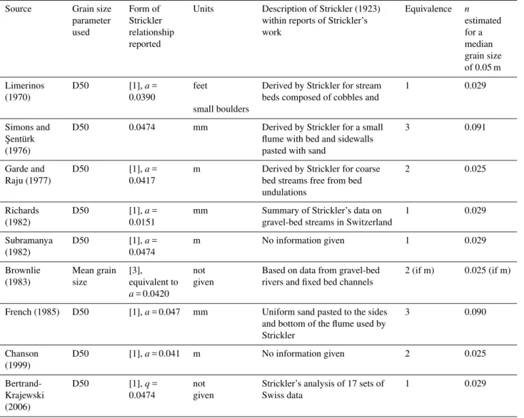
For some (e.g. Brownlie, 1983; Lebossé, 1991) the Man-ning equation became referred to as the ManMan-ning–Strickler equation (Bertand-Krajewski, 2006). Strickler (1923) pro-vided estimates of the coefficientain Eq. (3), which can be
readily transformed intoa′in Eq. (4). As French (1985) first noted, Strickler’s manuscript, published in German, is some-what obscure: it was a document prepared for the Swiss Can-tonal Authorities in Bern and is difficult to obtain. French also noted that Strickler has gone on to be reported in a mul-titude of ways and I have shown this in Table 2. There is variance between papers in the grain-size parameter used, the value of the exponent taken (aora′) and the units used. Some of the exponents can be shown to be equivalent (Table 2) by correcting for differences in units, but there remains a consid-erable variability between the estimates ofnobtained using different relationships. Thus, whilst Strickler brought in an attempt to controln, through relating it directly and contin-uously, if still empirically, to grain size, this relationship has remained remarkably unstable.
3.4 Challenges from fluid mechanics
Manning’s own work reflected a continual tension between a desire to bring in rational theory and the need to account for empirical evidence. Writing in 1878 (cited in Dooge, 1992) Manning noted “there are no formulae so useful – I might also say none of any real value – to the engineers, which are not in some degree empirical, embodying facts arrived at by careful experimentation.” However, there was another chal-lenge that paralleled the development of Manning’s n that comes from fluid mechanics. Darcy’s (1856) observations of pipe flow had shown that the distribution of velocity within the pipe depended upon pipe radius, implying that where the diameter was larger the influence of the pipe boundary was lower. This effect is implicit in the Manning equation as the hydraulic radius (R) appears as the numerator andnas the dominator. In 1914, Von Mises referred, for the first time, to the idea that roughness (k) in pipes of radius (r) should be seen as relative: in other words, the energy losses in a pipe should vary as a function of (k/r), so velocity should be some positive function ofr/ k. As Darcy was unable to measure close to the boundary, his inferences about bound-ary roughness, including determination of his friction factor, did not address specifically the nature of boundary effects. However, subsequent work sought to make the link between boundary influence and velocity, both theoretically and ex-perimentally. Key here is Prandtl (1926) who showed from theoretical analysis that velocity within a column of water (i.e.uiat elevationiabove the bed) should vary with the
log-arithm of elevation (y) above the bed if it is assumed that, effectively, the rate of turbulent energy production is a func-tion of the local velocity gradient:
ui =f (ln(y/y0)) . (6)
Table 2.Different forms of the Manning–Strickler equation.
Source Grain size Form of Units Description of Strickler (1923) Equivalence n
parameter Strickler within reports of Strickler’s estimated
used relationship work for a
reported median
grain size of 0.05 m
Limerinos D50 [1],a= feet Derived by Strickler for stream 1 0.029 (1970) 0.0390 beds composed of cobbles and
small boulders
Simons and D50 0.0474 mm Derived by Strickler for a small 3 0.091 ¸Sentürk flume with bed and sidewalls
(1976) pasted with sand
Garde and D50 [1],a= m Derived by Strickler for coarse 2 0.025 Raju (1977) 0.0417 bed streams free from bed
undulations
Richards D50 [1],a= mm Summary of Strickler’s data on 1 0.029 (1982) 0.0151 gravel-bed streams in Switzerland
Subramanya D50 [1],a= m No information given 1 0.029 (1982) 0.0474
Brownlie Mean grain [3], not Based on data from gravel-bed 2 (if m) 0.025 (if m) (1983) size equivalent to given rivers and fixed bed channels
a= 0.0420
French (1985) D50 [1],a= 0.047 mm Uniform sand pasted to the sides 3 0.090 and bottom of the flume used by
Strickler
Chanson D50 [1],a= 0.041 m No information given 2 0.025 (1999)
Bertrand- D50 [1],q= not Strickler’s analysis of 17 sets of 1 0.029 Krajewski 0.0474 given Swiss data
(2006)
of different diameter coated with sand grains of different but, within each experiment, uniform diameter: (1)y0 could be interpreted as the average projection of roughness; (2) this could be taken as the diameter (D) of sand grains used; and (3) as a result of experimental analysis, which produced a constantAin Eq. (5) of value 8.48,y0had to be multiplied to 30D. The integration of Eq. (6) across the flow depth, as Nikuradse did, and noting that his analysis is forpipeflow, shows that the depth-averaged velocity,Uis
U =f (ln(R/30D)) . (7)
Although this result is for a velocity profile rather than a section-averaged velocity, it has introduced a relative smoothness term,R/D, the reciprocal of a relative roughness term. Nikuradse (1933) specifically considered pipe flow, but Keulegan (1938) used Eq. (7) to develop a general equation for predicting mean velocity in turbulent open channel flow fromRandD. By the end of the 1930s, synchronously with
development of the Strickler relationship, fluid dynamicists had developed linkages between velocity prediction, the hy-draulic radius and the grain size of the boundary layer that had been translated into forms suitable for application to rivers.
3.5 Keeping the problem practical
size provided he controlled for flow depth effects. By 1957, Wolman was modelling roughness parameters (in this case the Darcy–Weisbach friction factor) as a function of relative smoothness (Leopold and Wolman, 1957). However, as Wol-man also recognised (WolWol-man, 1955; Leopold and WolWol-man, 1957), determining roughness from grain size, even if cor-rected for depth effects, overlooks the separate effects of other controls upon roughness (e.g. vegetation, bed forms, channel sinuosity etc.), grouped together by Luna Leopold, in a 1960 paper written jointly with Ralph Bagnold, Lu-cien Brush and Wolman in 1960, into distortion resistance (that associated with changes in flow direction) and spill re-sistance (that associated with rapid changes in flow velocity). Both Wolman and Leopold et al. (1960) were clear to point out that: “it is impossible here to evaluate the separate effects of these factors” (Wolman, 1955, p. 21) and “for practical reasons, distortion and spill resistance are largely overlooked because the large-scale and discrete boundary irregularities which cause them in natural channels are not easily described in quantitative terms” (Leopold et al., 1960, p. 112).
Yet, grain size can be measured, that is, it can be effec-tively used in an inscription device. Wolman (1955, p. 22) wrote “analysis shows that the hydraulic behaviour of “grain size” is a frictional factor, and as such, it is one of several re-lated factors which exercise a frictional resistance. A rough-nessn′, although perhaps not the most significant measure of energy and friction losses, is, at present, one which can be obtained under field conditions.” Thus, the mid-20th cen-tury history of Manning’sn, as illustrated here, shows how it remained markedly resistant to challenges from the rapidly developing field of fluid mechanics. It did so because its util-ity was not its theoretical superiorutil-ity, although it could be aligned with developing theory, but its suitability as some-thing that could be practically inferred from simple grain-size measurements which themselves could be made routine and reproducible. By showing how to make grain-size mea-surements reliable (in his classic “grid-by-number” sampling paper in 1954) and by following Strickler, Wolman affirmed grain size as an alternative kind of inscription device to pho-tographs (see also Limerinos, 1970), one which allowednto be proscribed in a generalised way.
Strickler’s work was developed explicitly by Limerinos in order to develop an “objective relation between Manning’sn
and streambed particle size” (Limerinos, 1970, 4) even if it “is not likely that the determination ofnvalues for natural channels will ever be an exact science” (Eq. 6). To do this, Limerinos embarked upon a very careful piece of research design where: “The most important criteria in selecting a site for study was that it be relatively free from velocity-retarding influences other than those associated with the size and size distribution of stream-bed particles” (1970, p. 13); and “sites that had an appreciable percentage of particles smaller than about 3/4 of an inch in diameter were eliminated from con-sideration to avoid the complication of having bed forms at a site – ripple, dune or plane bed – that varied with discharge”
(1970, p. 14). Here, Limerinos has established a network of suitable (field) laboratories where Manning’s n can be tied to measurement protocols that can guarantee an inter-nally consistent objectivity, even if the values of Manning’sn
that result are biased to the sites used to determine them. For Limerinos, even the measurability had to be reduced to questions of practicality: “The intermediate diameter of the streambed particles was studied because that is the diameter most easily measurable – either by sieve analysis or by pho-tographic techniques – and is the diameter that had been used in previous studies by other investigators” (1970, p. 6). 3.6 Digital roughness
The final stage of the history of Manning’sn relates to its appearance in prototype one-dimensional numerical mod-elling codes. The simplest, HEC-2, of these kinds of codes became available in the 1960s, produced by the US Army Corps of Engineers and released in 1966. Commonly called a “step-backwater” model, the codes use the energy equa-tion to calculate water surface profiles from the flow velocity (as defined by a given discharge) and energy losses between sections:
z2+d2+ ∝2V22
2g =z1+d1+ ∝1 V12
2g +hL12, (8)
wherezi is bed elevation at elevation at locationi,d is wa-ter depth;αis a coefficient;V is velocity andhLis the head loss between i−1 and i. The head loss is calculated from the energy loss due to friction between locations 1 and 2 and the energy loss due to expansion or cross section of the cross section between 1 and 2. The friction loss is commonly ex-pressed as a friction slope,sf, and commonly uses the Man-ning Eq. (2), including ManMan-ning’s n. Implicitly, Eq. (8) is represents the ability of a river to convey water where, in order to conserve mass, a decrease in velocity implies an in-crease in either or both of river width and flow depth. Subse-quent models were developed in the 1970s to include more complicated treatments (e.g. to allow for unsteady discharge) but they all share one critical characteristic: the models con-tain rules that need to represent conveyance, and in practice these are primarily built around the Eq. (2) Manning equation (HR Wallingford, 2001). With this development in the 1960s, Manning’snbecame implicated in the calculation of water surface profiles in predictive models of flood inundation. It is in this sense that Manning’snhas become most clearly re-sistant to generalisation and where its continued existence is linked to its status as an anti-fact.
programme of activities specifically to develop a Conveyance Estimation System that would regularise how conveyance es-timation was done in general and how Manning’snwas es-timated in practice. This system was launched in the UK in 2004 and had two elements: a Conveyance Generator and a Roughness Advisor (HR Wallingford, 2002). The basic ele-ment of the Roughness Advisor is a method for estimating unit roughness, expressed as ann, a basic roughness value that could be combined with estimates of energy losses due to turbulence, secondary circulation and channel sinuosity to estimate conveyance losses (HR Wallingford, 2003). The advisor allows both a description-based and photographic-based selection ofn. The reason for the choice ofnis made clear: it is sustained by a network of existing practice, as HR Wallingford (2004, p. 6) noted: “The use of the Man-ning n is widespread and to date, most resistance advice, pho-tographs and summation approaches in the literature are ex-pressed in terms of “n” (Barnes, 1967; Chow, 1959; Cowan, 1956; Hicks and Mason, 1998). The Roughness Advisor is therefore based on an n rather than a Darcyf or ChezyC, to maintain this user familiarity and confidence. This was a critical decision made by the Project User Consultative Group and Expert Advisory Board to receive wider user acceptance.”
Thenvalues were obtained from field measurements but also “some of the information in the roughness advisor is derived from expert opinion rather than field measurement” (HR Wallingford, 2004, p. 25). In this sense, the Roughness Advisor is a more sophisticated version of the Barnes (1967) photographs, but with a focus upon only unit roughness. However, the same report also demonstrates some resistance of Manning’snto conform to this advice (HR Wallingford, 2004, p. 27): “Calibration of the flow resistance alters the uncertainty in the estimation of conveyance. Calibration data for flow resistance should supersede the generic, non-site-specific information in the Roughness Advisor. Calibration may result in a different value for the central estimate of wa-ter level for the calibration flow rate and there is no guarantee that a single roughness value will achieve a perfect calibra-tion for water levels and flow rates observed on different oc-casions (due to natural variability).”
For this reason (HR Wallingford, 2004, p. 32) “The Roughness Advisor enables the user to manually overwrite the roughness values. This is essential for the calibration pro-cess. The values entered should be interpreted as equivalent unit roughness values, not the all-encompassing Manningn
values . . . ”.
These two quotes show how Manning’snclearly performs a function in computer models that is concerned with more than just describing energy losses: it is needed as a calibra-tion parameter, as a means of representing all those processes in the model not being modelled explicitly (Lane, 2005). Interviews with practising flood risk modellers conducted as part of a wider research project concerned with knowl-edge production in flood risk modelling (see also Whatmore
and Landström, 2011a; Landström et al., 2011a; Lane et al., 2011a) revealed the critical role of this calibration process: “. . . assuming all my rainfall data is right, and I am confi-dent in the hydrology (and that is a big assumption) what that means is that the model is underestimating the levels and it is too late, so what it probably needs is that I need to raise the channel resistance in that reach. You raise the channel resis-tance which would tend to put the level up a bit, but which might sort of not give you the right sort of timing. Then you reassess the assumption of the hydrology and you say – well, maybe I got the timed peak wrong on the catchment, so I go and reassess the timed peak on the catchment, so what you end up with is something that looks like that. So you think – well, maybe I am overestimating too much so perhaps I will bring my Manning’sndown a bit. Got the timing right now. So lo and behold you have got your really good match . . . ”.
This makes the estimation of flood levels critically depen-dent upon historical data, with one consultant noting (Lane et al., 2011a): “you have a whole raft of other sorts of data, verging from the completely anecdotal: “my kitchen flooded to six inches deep on this day”, to – if you are lucky, some aerial photography that shows the extent of flooding during an event. And again we would attempt to use that to calibrate or verify the models performance. When we don’t have that data the level of uncertainty significantly increases because you are basing it entirely on the physical assumptions of the model.”
This can create particular problems when those data are themselves uncertain: “A job we did not so long ago, we couldn’t get one of the records to fit at all, our model kept showing, I can’t remember what is was, but something like our levels were half a meter lower than the recorded levels, and we couldn’t get it up there at all. And after going round and round for months, it was decided that someone better go out and actually check the recorded level of this gauging sta-tion, and it was out by half a meter, so we had been trying to fix, fiddle, change things to match this data which was in fact wrong itself.” (Lane et al., 2011a).
a network of experience, the familiarity and confidence sur-rounding its use, but partly because it is the perfectanti-fact
in modelling practice. That is, it serves a role as something that has almost no directly derivable physical measure, it can only be derived from empirical relationships with other pa-rameters (e.g. grain size) that are themselves unstable (e.g. as a function of discharge, or position within a river system) and model predictions are extremely sensitive to its specification. As soon as Manning’snbecomes locked into an inscription device (a table, photographs, a software system) it can no longer provide its critical function, as an effective parameter (see Beven, 1989 for discussion of this notion), in compen-sating for all the other simplifications and inadequacies in hydraulic models. It is no longer available to make the model perform.
4 From Manning’snto performing hydrological prediction
The history of Manning’s n ends with the widespread use of a parameter that can be used to optimise model predic-tions through a process of calibration. It is possible to imag-ine the same kind of analysis being undertaken, albeit over different kinds of time frames, in other areas of hydrologi-cal prediction (with reference to the Topmodelmparameter, the widespread adoption of Gumbell-type distributions, the persistence of particular methods of assessing flood inunda-tion etc.). However, it also points to a wider issue relating to the role of performance in hydrological prediction and this is where wider science studies have demonstrated the need to move beyond work conducted in either the laboratory or the field to look at numerical prediction.
A wider science that studies the interest in prediction fol-lows from the argument that computer simulation as a prac-tice differs from other scientific approaches because it does not aim to produce new theoretical and general explanations of entities (Knuuttila, 2006) but rather to represent the be-haviour that emerges from interactions between those enti-ties (Landström et al., 2013). For instance, most hydrolog-ical models are based upon a set of theorethydrolog-ical statements (e.g. Darcy’s law, 1856) that are combined together, thus con-necting a set of variables that describe the state of the system at any one time. These variables then evolve as defined by their initial values and the theoretical statements but also ex-ternal forcing. Central to this process is the abstraction of the material world through the choice of particular theoret-ical statements and their subsequent mathemattheoret-ical descrip-tion and connecdescrip-tion in a hydrological model. Landström et al. (2011a, p. 3) describe this as “. . . rendering physical pro-cesses and events virtual in [hydrological or hydraulic] els . . . ” Studies of modelling practice have portrayed mod-elling as: (1) a different kind of laboratory work (e.g. Merz, 2006), reflecting the way in which modellers talk of “numer-ical experiments”; (2) something that, following Latour, is
coproduced with the social order within research communi-ties (e.g. Sundberg, 2009) as modellers develop very partic-ular ways of modelling (e.g. the use of hydrological models based upon similarity of hydrological response); and (3) cru-cially, something that is performative (Knuuttila, 2006; Peck, 2008; Guillemot, 2010) through its focus upon the extent to which predictions mimic measurements, that is, the model’s performance (see also Lane, 2012). Knuuttila (2006) argues that the value of a model depends upon its ability to bring about a prediction that is adequate even if elements of the model are demonstrably wrong. With respect to groundwa-ter models, this has been extensively discussed by Oreskes et al. (e.g. 1994) who talk of the ways in which modellers “force empirical adequacy” in their models, even if this means that they get the “right results” for the “wrong reasons” (Beven, 1989), or even the “wrong results” for the “wrong reasons” if the data that are the object of model forcing are not correct. Models are made to perform.