GUILHERME DE CASTRO PENA
MÉTODO PARA O POSICIONAMENTO DE
OBSERVADORES EM TERRENOS UTILIZANDO
PROGRAMAÇÃO PARALELA EM GPU
Dissertação apresentada à Universidade Federal de Viçosa, como parte das exigên-cias do Programa de Pós-Graduação em Ciência da Computação, para obtenção do título de Magister Scientiae.
VIÇOSA
Ficha catalográfica preparada pela Biblioteca Central da Universidade Federal de Viçosa - Câmpus Viçosa
T
Pena, Guilherme,
1988-P397m
2014
Método para o posicionamento de observadores em terrenos
utilizando programação paralela em GPU / Guilherme Pena. –
Viçosa, MG, 2014.
xi, 60f. : il. (algumas color.) ; 29 cm.
Orientador: Marcus Vinícius Alvim Andrade.
Dissertação (mestrado) - Universidade Federal de Viçosa.
Referências bibliográficas: f.57-60.
1. Programação paralela - Computação. 2. Visibilidade em
Terrenos. 3. Sistemas de informação geográfica. 4. otimização
combinatória. I. Universidade Federal de Viçosa. Departamento
de Informática. Mestrado em Ciência da Computação. II. Título.
GUILHERME DE CASTRO PENA
MÉTODO PARA O POSICIONAMENTO DE
OBSERVADORES EM TERRENOS UTILIZANDO
PROGRAMAÇÃO PARALELA EM GPU
Dissertation presented to the Graduate Program in Computer Science of the Fe-deral University of Viçosa in partial fulfill-ment of the requirefulfill-ments for the degree of Master in Computer Science.
VIÇOSA
“O pessimista vê dificuldade em cada oportunidade, o otimista, a oportunidade em cada dificuldade.” (Winston Churchill)
Agradecimentos
Agradeço primeiramente a Deus pela benção e por todas as coisas boas que aconte-cem em minha vida. O mestrado foi uma delas, um aprendizado que guardarei para sempre. Foram períodos apertados, porém sempre tive o apoio de uma pessoa em especial, meu orientador Prof. Marcus Vinicius Alvim Andrade. Uma pessoa bri-lhante que tive a honra de trabalhar nos últimos quatro anos, desde minha iniciação científica. Obrigado professor pelo conhecimento, pela paciência, pelo profissiona-lismo, pela simpatia. Agradeço também ao Prof. Salles V. G. Magalhães por toda a sua ajuda, conhecimento e trabalho. Agradeço ao amigo Chaulio R. Ferreira e a to-dos amigos do grupo de pesquisa do prof. Marcus pela ajuda. Gostaria de agradecer também a todos colegas, funcionários e professores do departamento de informática em especial ao prof. José Luís Braga. Inclusive agradeço ao departamento por todo o apoio e excelentes condições de trabalho.
Agradeço aos órgãos de financiamento CAPES, CNPq, FAPEMIG, NSF e ao Prof. Franklin que tornaram possível o desenvolvimento dos meus projetos de pesquisa.
Em especial, agradeço a todos os meus familiares, meus pais José e Ângela por todo amor, apoio e incentivo e meu irmão André. A todos os meus amigos e colegas de curso que sempre me motivaram. Agradeço aos integrantes da banda “Só penna que vua” pela diversão sempre presente.
Agradeço a todos vocês que construíram comigo mais este sonho. Do fundo do meu coração, muito obrigado!
Sumário
Lista de Figuras vi
Lista de Tabelas viii
Lista de Abreviaturas e Siglas ix
Resumo x
Abstract xi
1 Introdução geral 1
1.1 O Problema do Posicionamento de Observadores . . . 3
1.2 Objetivos . . . 4
1.3 Resultados obtidos . . . 4
2 Algoritmo paralelo usando GPU para o posicionamento de ob-servadores em terrenos 7 2.1 Introdução . . . 7
2.2 Referencial Teórico . . . 8
2.2.1 Visibilidade . . . 8
2.2.2 CUDA e programação paralela de propósito geral . . . 9
2.3 A heurística proposta . . . 9
2.3.1 A busca local Swap . . . 10
2.3.2 Implementação eficiente da heurística Swap . . . 11
2.4 Resultados experimentais . . . 12
2.5 Conclusão . . . 13
3 An Improved Parallel Algorithm using GPU for Siting Observers on Terrain 15 3.1 Introduction . . . 15
3.2 Background . . . 17
3.2.1 Terrain Visibility Definitions . . . 17
3.2.2 Parallel Programming Using General Purpose GPU . . . 18
3.3 Related Work . . . 19
3.4 The site method . . . 20
3.5 Observer siting in GPU . . . 21
3.5.1 The Local Search - Swap . . . 22
3.5.2 An Efficient Swap Heuristic Implementation . . . 23
3.6 Experimental Results . . . 28
3.7 Conclusion . . . 29
4 An efficient GPU multiple-observer siting method based on sparse-matrix multiplication 33 4.1 Introduction . . . 33
4.2 Terrain Visibility Definitions . . . 35
4.3 Related Work . . . 36
4.4 The proposed method . . . 38
4.4.1 The Local Search - Swap . . . 38
4.4.2 An Efficient Swap Heuristic Implementation . . . 41
4.4.3 Using a sparse-dense matrix multiplication algorithm . . . 43
4.4.4 Reducing the swap heuristic’s memory usage . . . 45
4.5 Experimental Results . . . 46
4.6 Conclusions and future work . . . 51
5 Conclusões gerais e trabalhos futuros 55
Referências Bibliográficas 57
Lista de Figuras
1.1 Tipos de amostragem de pontos e formas de representação de MDEs.
Fonte: [Câmara et al., 2001] . . . 2
(a) Amostragem Irregular . . . 2
(b) Amostragem Regular . . . 2
(c) Malha Triangular . . . 2
(d) Grade Regular . . . 2
3.1 Visibility queries using a line of sight. Source: [Magalhães et al., 2011b] . 17 3.2 Comparison between GPUs and CPUs structures. Source: [NVIDIA, 2014] 19 3.3 Given A = {V1, V2, V3, V4, V5}, S′ are the neighbors of the solution S = {V1, V2, V3}. . . 23
3.4 Matrix illustrating Vr in a solution withk = 5 observers. . . 25
3.5 Matrix Multiplication Algorithm. . . 27
(a) Matrices on global memory. . . 27
(b) Iterative load in the GPU’s shared memory. . . 27
(c) Writing back to the global memory. . . 27
3.6 The blocks are labeled as following: if all the cells in the block are not visible, the block is labeled with 0; otherwise with 1. . . 28
(a) Original V matrix. . . 28
(b) Mask-matrix overV. . . 28
3.7 Observers sited in terrain1201x1201with desired coverage25%and radii of interest: 100 (a), 200 (b) and 300 (c). The observers are indicated by yellow triangles and visible points are showed in red. . . 30
4.1 Visibility queries using a line of sight. Source: [Magalhães et al., 2011b] . 35 4.2 Given V ={V1, V2, V3, V4, V5}, each Si′ is obtained performing a swap in S={V1, V2, V3}. . . 39
4.3 Matrix illustrating Vr in a solution withk = 5 observers. . . 41
4.4 ELLPACK-R matrix format representation: (a) an example showing how the matrix is packed; (b) how the viewshed matrix (from Figure 3.6a) is
packed using this representation. . . 44
(a) Source: [Wafai et al., 2009] . . . 44
(b) . . . 44
4.5 Matrix illustrating V3···6 in a solution with k = 7 observers. Notice that the base case for computing matrix λ− is λ− 3 (indicated in gray) and, similarly, the base case for computing λ+ is λ+6. . . 46
4.6 Processing-time and memory usage of SparseSite as a function of the number of rows (nr) of the dense matrix that is kept in the memory. . . 49
4.7 Processing time (in seconds) of the three methods (SparseSite, SiteGSM and Site+) to site observers with radius of interest (R) of 200 (a), 300 (b) and400(c) cells on the terrain with36012 cells. For clarity purposes, the y-scale is logarithmic. . . 53
(a) R= 200. . . 53
(b) R= 300. . . 53
(c) R= 400. . . 53
4.8 Comparison of a solution obtained by the greedy method against a solu-tion obtained for the greedy method improved with theswap local search. 54 (a) Greedy method. . . 54
(b) Greedy method improved with the swap heuristic. . . 54
Lista de Tabelas
1.1 Comparação dos algoritmos descritos com relação às estratégias adotadas e detalhes de implementação. . . 6
2.1 Tempos de execução da heurística convencional (em CPU) e da heurística proposta; neste caso, são apresentados os tempos para obtenção do vi-ewshed acumulado (Υ), da área visível e tempo total incluindo operações
de entrada e saída. . . 13
3.1 Processing time (in seconds) of three methods: two parallel methods using GPU (SiteGSM and SiteGPU) and a sequential one (Site+) to site observers on terrains with different sizes considering different radii of interest (R) to achieve some desired coverages (Ω). . . 31 3.2 Table of notations. . . 32
4.1 Processing time of SparseSite in large terrains. . . 48 4.2 Processing-time and memory usage of SparseSite as a function of the
number of rows (nr) of the dense matrix that is kept in the memory.
These tests were performed on Terrain 3, using radius of interest equal to200 cells and desired coverage of 95%. . . 48
4.3 Processing time (in seconds) of three methods: two parallel methods using GPU (SparseSite and SiteGSM) and a sequential one (Site+) to site observers on terrains with different sizes considering different radii of interest (R) to achieve some desired coverages (Ω). The speedup of each method (compared againstSite+) is shown in parenthesis. . . 50 4.4 Comparison of the processing time and number of observers used by the
SparseSite heuristic (greedy with local search) and by the Site method (greedy heuristic). The last column presents the percentual difference in the number of observers used by the heuristics. . . 51
Lista de Abreviaturas e Siglas
CPU - Central Processing Unit
CUDA - Compute Unified Device Architecture
GPGPU - General Purpose Graphic Processing Units
GPU - Graphics Processing Unit
MDE - Modelo Digital de Elevação
MDT - Modelo Digital de Terreno
RSG - Regular Square Grid
SIG - Sistemas de Informação Geográfica
SIMD - Single Instruction Multiple Data
SM - Stream Multiprocessors
SRTM - Shuttle Radar Topography Mission
TIN - Triangulated Irregular Network
Resumo
PENA, Guilherme de Castro, M.Sc., Universidade Federal de Viçosa, agosto de 2014. Método para o posicionamento de observadores em terrenos utilizando programação paralela em GPU. Orientador: Marcus Vinícius Alvim Andrade.
Este trabalho apresenta um algoritmo eficiente, chamado SparseSite, para solucio-nar o problema do posicionamento de observadores em terrenos. Este problema é uma aplicação do conceito de visibilidade que consiste em determinar quais pontos do terreno são visíveis a partir de um ponto específico, denominado observador, e o conjunto de pontos visíveis por este observador é chamado mapa de visibilidade ou viewshed. Assim, o objetivo do problema é selecionar um conjunto de observa-dores cujos os viewsheds otimizem a cobertura do terreno, com aplicações nas áreas de telecomunicações, planejamento ambiental, monitoramento militar, entre outras. Segundo Nagy [1994], este problema é NP-Difícil e portanto, não se conhece um al-goritmo eficiente que encontre a sua solução ótima. Assim, em geral, este problema é solucionado usando métodos heurísticos. Porém, mesmo as soluções aproximadas podem demandar um longo tempo de processamento devido ao grande volume de dados a ser analisado. O algoritmo descrito neste trabalho adota estratégias de programação paralela voltadas para arquiteturas de placas gráficas (GPUs) e além disso, permite o processamento de grandes volumes reorganizando os dados de en-trada do problema e capacitando o usuário a gerenciar o uso de memória pela GPU. Ele é uma extensão do método Site proposto por Franklin [2002]. A heurística uti-lizada encontra soluções melhores do que as encontradas pelo método Site, isto é, usando um número menor de observadores. Os resultados experimentais mostraram que, comparado aos principais algoritmos descritos na literatura, o nosso método se mostrou muito mais eficiente do que eles, sendo mais de 7000 vezes mais rápido do que o método que não utiliza nenhuma técnica de melhoria e mais de 20 vezes mais rápido do que o método paralelo anterior. Além disso, foram realizados testes do SparseSite para processar volumes de dados que não puderam ser processados pelos outros métodos devido à limitações de memória ou por demandarem muito tempo de processamento. Por fim, comparado ao nosso algoritmo anterior SiteGSM, o SparseSite é quase 3 vezes mais rápido e usa 10% da memória usada por ele.
Abstract
PENA, Guilherme de Castro, M.Sc., Universidade Federal de Viçosa, August, 2014. Method for siting observers on terrains using GPU parallel programming. Adviser: Marcus Vinícius Alvim Andrade.
This work presents an efficient algorithm , named SparseSite, to siting observers on terrains. This problem concerns visibility, that is, determining the set of points that are visible from a particular point, called observer, and the set of visible points from this observer is called viewshed. Thus, the goal of this problem is to select a set of observers in order to “optimally” cover the terrain. The applications include telecommunications, environmental planning, military monitoring and so forth. Ac-cording to Nagy [1994], the siting problem is NP-Hard and, therefore, there is no known efficient algorithm to find its optimal solution. Thus, in general, it is used a heuristic to obtain an approximate solution. But even obtaining approximate solutions for this optimization problem can demand a long processing time since sometimes it is necessary to process a huge amount of high-resolution geographic data. The algorithm described in this work adopts parallel programming strategy for graphics processing units (GPUs) and furthermore, it allows the processing of large data volumes rearranging the input data of the problem and enabling the user to manage the memory usage by the GPU. This algorithm extends the method Site proposed by Franklin [2002] and the heuristic used finds even better solutions than those found by the method Site. The experimental results showed that, compared against the mainly algorithms described in previous works, our method proved to be more efficient than all of them, more than 7000 times faster than the sequential method without improvement techniques and 20 times faster than a previous pa-rallel method. Additionally, some tests of the SparseSite were performed to process volumes of data which cannot be processed by the other methods due to memory limitations or to demand a lot of processing time. Lastly, compared against our previous algorithm SiteGSM, the SparseSite is almost 3 times faster and uses 10% of the amount of memory used by it.
1.
Introdução geral
A modelagem digital de terrenos desempenha um importante papel nos Sistemas de Informação Geográfica (SIG) em diversas questões tais como visibilidade, hidrogra-fia, roteamento, entre outras [Goodchild et al., 2005]. Em particular, o conceito de visibilidade em terrenos consiste em determinar quais pontos do terreno são visíveis a partir de um ponto específico, denominadoobservador, e o conjunto de pontos visí-veis por este observador é chamado mapa de visibilidade ouviewshed. O observador pode estar localizado a uma certa altura acima do solo. Telecomunicações, plane-jamento ambiental, monitoramento militar são exemplos de importantes aplicações práticas que envolvem este conceito [Franklin and Ray, 1994; Li et al., 2005; Nagy, 1994; Andrade et al., 2011]. Dentre estas aplicações, pode-se destacar o problema do posicionamento de observadores, onde o objetivo é selecionar um conjunto de observadores que otimize a cobertura sobre o terreno. Estes observadores podem representar torres de radio, TV, telefonia móvel, Internet [Hrovat et al., 2010], ou câmeras ou torres de monitoramento [Ben-Moshe, 2005; Ben-Shimol et al., 2007]. Por exemplo, se um observador representar uma torre de telefonia celular, seu vi-ewshed representaria as áreas do terreno onde se espera que um usuário do serviço de telefonia consiga obter sinal diretamente a partir dessa torre e assim, o problema do posicionamento poderia ser tratado de duas formas, determinar o número mínimo de torres de celular necessárias para cobrir uma certa região ou determinar a maior área possível coberta por um dado número de torres.
Em geral, os modelos digitais de terreno (MDTs) usados por estas aplicações possuem informações sobre a elevação da superfície terrestre. Segundo Câmara et al. [2001], a aquisição de dados geográficos para a construção desses modelos pode ser feita através da amostragem de pontos espaçados de forma irregular ou regular, Figuras 1.1a e 1.1b. Dessa maneira, a superfície da Terra é representada de forma aproximada utilizando um modelo digital de elevação (MDE), que armazena as elevações dos pontos amostrados. As amostras são armazenadas em estruturas de dados definidas de forma a possibilitar uma manipulação eficiente pelos algoritmos de análise contidos nos Sistemas de Informação Geográfica. No caso de amostras irregularmente espaçadas, normalmente utilizam-se estruturas de dados de malha triangular, denominadas triangulated irregular networks (TINs), Figura 1.1c. Para o caso de amostras regularmente espaçadas é possível utilizar estruturas de dados
1. Introdução geral 2
mais simples, como grades regulares (regular square grids - RSGs) que consistem em matrizes que armazenam as elevações dos pontos amostrados, Figura 1.1d.
(a) Amostragem Irregular (b) Amostragem Regular
(c) Malha Triangular (d) Grade Regular
Figura 1.1: Tipos de amostragem de pontos e formas de representação de MDEs. Fonte: [Câmara et al., 2001]
1. Introdução geral 3
1.1
O Problema do Posicionamento de
Observadores
Como mencionado anteriormente, o problema do posicionamento de observadores consiste em selecionar um conjunto de observadores que otimize a “cobertura” sobre um terreno. Conforme demonstrado em Nagy [1994], este problema é NP-Difícil e portanto, não se conhece um algoritmo eficiente que encontre a sua solução ótima. Dessa forma, geralmente são usados métodos heurísticos para se obter uma solu-ção aproximada. Contudo, mesmo a obtensolu-ção de soluções aproximadas para este problema de otimização pode demandar um longo tempo de processamento uma vez que é necessário processar um grande volume de dados de alta resolução. Por exemplo, a base de dados SRTM (Shuttle Radar Topography Mission) [Rabus et al., 2003], criada no ano de 2000 e que ainda é amplamente usada por pesquisadores, possui em torno de10terabytes de dados terrestres disponíveis com resoluções de 30 e 90 metros. Atualmente, novas tecnologias de sensoriamento remoto são capazes de amostrar elevações com resoluções de 1 metro ou até mesmo submétricas gerando matrizes de elevação ainda maiores. Por exemplo, uma região de 500km×500km amostrada à 1 metro gera um terreno de 500 gigabytes aproximadamente.
Sendo assim, as aplicações em SIGs demandam o desenvolvimento de novas técnicas para processar esse volume de dados. Uma técnica bem sucedida, que é explorada por este trabalho, é o projeto de algoritmos paralelos baseados em unidades de processamento gráfico para propósito geral (General Purpose Graphic Processing Units - GPGPUs). Novas placas gráficas (GPUs) fornecem recursos que permitem o desenvolvimento de algoritmos bastante eficientes em um amplo domínio de aplicações [NVIDIA, 2014].
Dentre os algoritmos encontrados na literatura que solucionam o problema do posicionamento de observadores, destacam-se o método Site [Franklin, 2002] e os métodos Site+ [Magalhães et al., 2010], SiteGPU [Magalhães et al., 2011a] e EMSite [Magalhães et al., 2011b] que são extensões do algoritmo Site adotando diferentes estratégias, porém no processamento de grandes volumes de dados, alguns deles possuem restrições práticas com relação ao uso de memória e outros demandam longos tempos de processamento. Mais detalhes desses métodos serão descritos posteriormente.
1. Introdução geral 4
se mostrou eficiente quando comparada aos métodos disponíveis na literatura para processar maiores volumes de dados. Além disso, a possibilidade de gerenciar o uso da memória de placas gráficas permite que o método aqui proposto seja executado em placas de custo relativamente mais baixo, que possuem menores quantidades de memória disponível.
1.2
Objetivos
O objetivo geral deste trabalho foi o desenvolvimento de um método eficiente ca-paz de solucionar o problema de posicionamento de observadores. O método deve considerar que grandes volumes de dados deverão ser manipulados, de modo que deverá gerenciar adequadamente os recursos disponíveis no computador, em parti-cular a memória. Para alcançar este objetivo geral, destacam-se alguns objetivos específicos:
• Propor e implementar um algoritmo que utilize as modernas arquiteturas pa-ralelas de GPUs para realizar o processamento de forma mais eficiente;
• Realizar a análise de complexidade dos algoritmos desenvolvidos;
• Avaliar experimentalmente os algoritmos desenvolvidos, comparando-os com
outros métodos encontrados na literatura.
1.3
Resultados obtidos
Os Capítulos de 2 a 4 são apresentados na forma de artigos e descrevem os resultados obtidos neste trabalho que são baseados no método Site, proposto por Franklin [2002], e nos métodos Site+ [Magalhães et al., 2010] e SiteGPU [Magalhães et al., 2011a] que também correspondem a extensões do método Site. A comparação dos algoritmos é apresentada na Tabela 1.1.
Resumidamente, o método Site obtém uma solução aproximada baseada na estratégia gulosa para solucionar o posicionamento de observadores onde o objetivo é obter o número mínimo de observadores para alcançar uma determinada cobertura do terreno. Este método inicializa a solução como vazia e a cada iteração seleciona o observador (ainda não incluído na solução) que gera o maior aumento na cobertura total da sub-solução corrente.
1. Introdução geral 5
Site onde a ideia básica é incluir uma busca local cujo objetivo é verificar se a troca de um observador já selecionado com algum outro ainda não selecionado leva a um aumento da cobertura. Ao final desta verificação, a busca local seleciona a melhor troca, isto é, aquela que gera o maior aumento. Como demonstrado por Magalhães et al. [2010], apesar de gastar mais tempo de processamento pela inclusão da busca local, esta nova estratégia permite que se use um número menor de observadores para atingir a mesma taxa de cobertura. Esta redução pode representar uma eco-nomia significativa visto que um observador pode ser uma instalação de alto custo (por exemplo, uma torre de celular).
Este trabalho descreve uma nova implementação paralela usando GPU da es-tratégia baseada na busca local [Magalhães et al., 2010]. O Capítulo 2 corresponde ao artigo “Algoritmo paralelo usando GPU para o posicionamento de observadores em terrenos” apresentado no GeoInfo 2013 (XIV Brazilian Symposium on GeoInfor-matics) [Pena et al., 2013]. Esse artigo descreve o algoritmo SiteGSM (Site using GPU shared memory) que destaca-se pela definição de uma nova implementação usando programação dinâmica executada na CPU em uma etapa intermediária do processo e usando a hierarquia de memórias da GPU na etapa posterior, com uso da memória compartilhada e da memória global da placa, atingindo maior eficiência do que os outros métodos. Nesse artigo, o problema do posicionamento foi tratado de modo a obter a maior cobertura possível atingida por um conjunto com um dado número de observadores. O SiteGSM foi comparado experimentalmente com o método Site+ [Magalhães et al., 2010] que propõe uma implementação convenci-onal dessa mesma estratégia usando apenas a CPU. Os resultados mostraram que o SiteGSM chegou a ser, em muitos casos, mais de 200 vezes mais rápido do que o método Site+.
1. Introdução geral 6
implementa algumas rotinas usadas pela heurística em GPU e mantém todos os dados na memória global da placa. Os resultados mostraram que o novo algoritmo SiteGSM chegou a ser, em alguns casos, mais de 20 vezes mais rápido do que o método SiteGPU e mais de 1200 vezes mais rápido do que o método Site+.
Finalmente, o capítulo 4 se refere ao artigo “An efficient GPU multiple-observer siting method based on sparse-matrix multiplication” submetido à ACM SIGSPA-TIAL 2014 (22nd ACM SIGSPATIAL International Conference on Advances in Geographic Information Systems) [Pena et al., 2014b]. Neste artigo é apresentado o algoritmo SparseSite que se baseia no uso de matrizes esparsas para representar um conjunto de viewsheds que é considerado esparso e na adaptação de um algo-ritmo para multiplicação destas matrizes. Essa adaptação realiza sobreposição de matrizes e depois uma contagem para determinar a sua área total de visibilidade. Além disso, para reduzir a quantidade de memória usada pelo método, foi adotada a estratégia de particionar o processamento da matriz que armazena a sobreposi-ção dos viewsheds da sub-solução. Essa ideia proposta no SparseSite fez com que o algoritmo mantivesse a eficiência do método SiteGSM usando uma quantidade muito menor de memória e assim, permitiu-se o processamento de maiores volumes de dados. Ele foi comparado experimentalmente com o método Site+ e com o mé-todo anterior SiteGSM. Os resultados mostraram que o novo algoritmo SparseSite chegou a ser, em alguns casos, quase 3 vezes mais rápido do que o método SiteGSM e mais de 7000 vezes mais rápido do que o método Site+. Além disso, é importante mencionar que o novo método SparseSite atinge estes resultados usando em média 10% da memória usada pelo método SiteGSM.
Tabela 1.1: Comparação dos algoritmos descritos com relação às estratégias adota-das e detalhes de implementação.
Algoritmo
Estratégia Implementação
Gulosa Gulosa com Somente CPU e Programação Programação Busca Local CPU GPU Dinâmica Dinâmica em GPU
Site x x
Site+ x x
SiteGPU x x
SiteGSM x x x
2.
Algoritmo paralelo usando GPU para o
posicionamento de observadores em
ter-renos
1
Abstract
This paper presents an efficient method for sitting a set of observers to maximize the coverage of a given terrain. It is based on an efficient imple-mentation of a local search heuristic using dynamic programming and GPU parallel programming. The tests showed that the proposed method can be more than 200 times faster than the conventional implementation (with no use of dynamic programming and GPU parallel programming).
Resumo
Este artigo apresenta um método eficiente para o posicionamento de um conjunto de observadores de modo a maximizar a cobertura de um dado terreno. A estratégia proposta se baseia na implementação eficiente de uma heurística de busca local utilizando programação dinâmica e programação pa-ralela (em GPU). Os testes mostraram que este método chega a ser mais de 200 vezes mais rápido que a implementação convencional (sem o uso de pro-gramação dinâmica e paralela).
2.1
Introdução
Um importante grupo de aplicações na área de Sistemas de Informação Geográficas envolve o conceito de visibilidade em terrenos, que consiste em determinar os pontos do terreno que são visíveis a partir de um dado ponto (observador). Este problema possui muitas aplicações práticas, tais como telecomunicações, planejamento am-biental, e monitoramento militar [Ben-Shimol et al., 2007; Bespamyatnikh et al., 2001]. Um problema importante relacionado à visibilidade é o posicionamento de
1
Neste capítulo é apresentada uma primeira versão do método SiteGSM. Nele está incluído o artigo “Algoritmo paralelo usando GPU para o posicionamento de observadores em terrenos”, apresentado no GeoInfo 2013 (XIV Brazilian Symposium on GeoInformatics) [Pena et al., 2013].
2. Algoritmo paralelo usando GPU para o posicionamento de
observadores em terrenos 8
observadores para maximizar a “cobertura do terreno”, sendo que estes “observado-res” podem ser câmeras, torres de vigilância ou de telefonia móvel, etc. [Ben-Shimol et al., 2007; Franklin and Vogt, 2006; Eidenbenz, 2002]. Conforme demonstrado em Nagy [1994] este problema é NP-Difícil e portanto, não se conhece um algoritmo eficiente para resolvê-lo de maneira exata.
Mas, até mesmo a obtenção de soluções aproximadas para este problema de otimização demanda um alto tempo de processamento, principalmente ao processar grandes volumes de dados. Uma forma de reduzir esse tempo de processamento con-siste em desenvolver algoritmos paralelos baseados nas unidades de processamento gráfico para propósito geral (GPGPUs), que estão presentes na maioria das placas gráficas atuais.
Este trabalho apresenta uma implementação paralela utilizandoGPU de uma heurística para solucionar o problema do posicionamento de observadores em um terreno representado por um MDE raster. Mais precisamente, a heurística proposta visa maximizar a área coberta no terreno por um dado número de observadores.
2.2
Referencial Teórico
2.2.1
Visibilidade
Um terreno é uma representação da elevação da superfície terrestre em uma deter-minada região que, neste trabalho, será representado por uma matriz de elevação (ou MDE) que armazena a elevação de amostras do terreno regularmente espaça-das [Felgueiras, 2001].
Umobservador é um ponto do espaço que “deseja” visualizar ou se comunicar com outros pontos do espaço chamados de alvos. Tanto o observador como o alvo podem estar a uma certa altura acima do terreno. Existem vários algoritmos para o cálculo da visibilidade e, em geral, eles adotam que um alvo T é visível a partir de um observador O se, e somente se, T estiver dentro do raio de interesse de O e não houver nenhum ponto do terreno bloqueando o segmento de reta que conecta O a T.
2. Algoritmo paralelo usando GPU para o posicionamento de
observadores em terrenos 9
2.2.2
CUDA e programação paralela de propósito geral
Atualmente, uma técnica de programação paralela que tem sido muito utilizada é a GPGPU [NVIDIA, 2014], que consiste em utilizar os vários núcleos de processa-mento presentes em GPUs para processar dados. O modelo de programaçãoCUDA facilita o desenvolvimento de aplicativos capazes de aproveitar o poder de processa-mento das GPUs da NVIDIA, que são compostas por vários processadores do tipo SIMD e possibilitam a execução de milhares de threads de forma paralela.
A arquitetura CUDA permite a execução de código tanto na CPU quanto na GPU. Assim, o processador principal (CPU) pode executar trechos de código que envolvam menos paralelismo e maior quantidade de estruturas de controle de fluxo de execução (que normalmente não são processadas de forma eficiente em arquiteturas SIMD) e designar para a execução na GPU funções que possam ser aplicadas de forma paralela sobre diferentes elementos de dados. Dessa forma, aGPU é utilizada como um co-processador que é capaz de executar certos tipos de tarefas de forma mais eficiente do que a CPU.
2.3
A heurística proposta
A solução proposta neste artigo consiste em implementar uma heurística de busca local (Swap) de forma eficiente utilizando CUDA e programação dinâmica. Mais precisamente, a heurística (Swap) será utilizada para aumentar a área visível de soluções previamente obtidas utilizando o método Site [Franklin and Vogt, 2006], que é baseado em uma heurística gulosa. Assim, dada uma solução obtida pelo método Site (ou por qualquer outro método), o método proposto tenta melhorar esta solução realizando operações de busca local baseadas em trocas (Swap) de observadores (viewsheds) para aumentar o número de pontos visíveis no viewshed acumulado, mantendo fixo o número de observadores utilizados na solução.
2. Algoritmo paralelo usando GPU para o posicionamento de
observadores em terrenos 10
2.3.1
A busca local
Swap
Dado um conjunto de n observadores candidatos, seja V ={V1,· · ·Vn} o conjunto
com os respectivos viewsheds e seja S um subconjunto de V contendo k viewsheds representando uma solução para o problema de posicionamento de observadores. Assim, o objetivo da heurística Swap é realizar uma busca local para maximizar o número de pontos visíveis no viewshed acumulado de k observadores selecionados dentre os n candidatos.
Mais especificamente, a ideia da heurística Swap consiste em verificar iterati-vamente todas as soluções vizinhas à solução S e, a cada passo, substituir S pela solução vizinha com maior área visível. Dada uma solução S, as vizinhas deS são todas as soluções S′ onde exatamente um dos viewsheds em S′ é diferente de um
viewshed deS. Por exemplo, se V ={V1, V2, V3, V4} e S ={V1, V2, V3}, as soluções
vizinhas aS são: {V1, V2, V4},{V1, V4, V3},{V4, V2, V3}. O processo de trocar a
solu-ção atual pela melhor vizinha é repetido até ser obtida uma solusolu-ção que não possua melhores vizinhas.
Assim, considerando cada viewshed representado por uma matriz linearizada de inteiros (onde os números 0 e 1 representam, respectivamente, pontos não visíveis e visíveis), a heurística Swap pode ser implementada (sequencialmente) da seguinte forma: dados osviewsheds candidatosV1,· · ·Vn, sejaSuma solução composta pork
viewsheds, isto é,S ={Vi1,· · · , Vik}cujoviewshed acumulado é dado porVi1⊕ · · · ⊕
Vik onde ⊕ representa a união de dois viewsheds
2. Além disso, seja
Υr o viewshed
acumulado envolvendo todos osviewsheds emS exceto oviewshed Vir. Daí, em cada
iteração da heurística são geradas todas as soluções vizinhas a S e a melhor delas é selecionada para ser a solução corrente utilizada na próxima iteração. As soluções vizinhas a S são geradas fazendo-se Υr⊕Vj para r= 1· · ·k e j = 1· · ·n.
A etapa que demanda maior tempo de processamento na heurística Swap é o cálculo da área visível para cada solução vizinha. O Algoritmo 1 apresenta o pseudocódigo dessa etapa, onde Area[r][j] representa o número de pontos visíveis em Υr⊕Vj e, portanto, essa matriz pode ser utilizada para se obter qual é a melhor
vizinha de S.
Por motivos de eficiência, neste trabalho os viewsheds foram codificados em palavras de 64 bits (onde cada palavra representa a visibilidade de 64 pontos no terreno). Com isso, a união de viewsheds e o cálculo da área visível podem ser realizadas utilizando, respectivamente, o operador or de bits e funções de
conta-2
A união de dois viewsheds pode ser realizada aplicando-se a operaçãoorbinária entre cada
2. Algoritmo paralelo usando GPU para o posicionamento de
observadores em terrenos 11
Algoritmo 1Calcula a matrizArea;VSizeé o número de pontos em cadaviewshed.
1: Area[1..k][1..n]← {{0}}
2: for r = 1→k
3: for j = 1 →n
4: for w= 1 →VSize
5: Area[r][j]←Area[r][j] + (Υ[r][w] or V[j][w])
gem de população, que são operações disponibilizadas no hardware da maioria dos computadores atuais.
2.3.2
Implementação eficiente da heurística
Swap
Note que para gerar os valores de Υr com r = 1· · ·k, o algoritmo descrito na
seção 2.3.1 realiza k×n = Θ(kn) operações ⊕ de união de viewsheds (sendo que cada união envolve Θ(VSize) posições na matriz dos viewsheds).
Conforme descrito a seguir, a eficiência dessa etapa do algoritmo pode ser melhorada consideravelmente utilizando-se programação dinâmica. Para simplificar a notação, sejam ν1,· · ·νk os k viewsheds selecionados para formar a solução S, ou
seja, ν1,· · ·νk = Vi1· · ·Vik. Assim, Υr = (ν1 ⊕ν2 ⊕...⊕νr−1)⊕(νr+1 ⊕νr+2 ⊕
· · · ⊕νk). Sejam λr = (ν1⊕ν2 ⊕...⊕νr−1) e λr = (νr+1⊕νr+2⊕ · · · ⊕νk). Note
que λr pode ser obtido com base na seguinte equação de recorrência: λ1 = ∅ e
λr = (ν1 ⊕ν2 ⊕...⊕νr−1) = (λr−1 ⊕νr−1). De forma análoga, temos que λk =
∅ e λr = (νr+1 ⊕νi+2 ⊕ · · · ⊕νk) = (νr+1 ⊕λr+1). Daí, Υr = λr ⊕ λr. Essas
relações de recorrência foram utilizadas para implementar um algoritmo baseado em programação dinâmica para o cálculo da matriz que representa os valores de Υ,
sendo que este algoritmo realiza Θ(k)uniões de viewsheds.
Após o cálculo de Υ, o próximo passo consiste em utilizar esses valores para realizar uma iteração da heurísticaSwap. Uma forma de se implementar essa etapa na GPU consiste em manter todos os viewsheds na memória global da GPU e, então, utilizar cada thread para calcular cada um dos elementos da matriz Area. Essa implementação convencional não aproveitaria de forma eficiente todo o poder da GPU, pois os acessos seriam realizados na memória global, que é mais lenta do que outras memórias, como a memória compartilhada. Como a capacidade da memória compartilhada é muito pequena, ela não é capaz de armazenar todos os dados e, portanto, é necessário adotar uma estratégia de dividir o processamento para que os cálculos possam ser realizados por partes.
2. Algoritmo paralelo usando GPU para o posicionamento de
observadores em terrenos 12
similar ao padrão de acesso utilizado em um algoritmo de multiplicação de matrizes, onde as matrizes Υe VT são multiplicadas para gerar a matriz Area. A única
dife-rença entre o Algoritmo 1 e um algoritmo de multiplicação de matrizes é que, no al-goritmo de multiplicação, a operaçãoArea[r][j]←Area[r][j]+(Υ[r][w] or V[j][w])
(linha 5) é substituída pela operação Area[r][j]←Area[r][j] + Υ[r][w]×VT[w][j].
Assim, podemos utilizar as técnicas de otimização adotadas na implementação em GPU de algoritmos de multiplicação de matrizes. Neste trabalho, utilizamos (adaptamos) o algoritmo de multiplicação de matrizes descrito em NVIDIA [2014], substituindo a operação de multiplicação por uma operação de or binário seguida por uma operação de contagem de população. Esse algoritmo divide as matrizes em blocos, que são carregados iterativamente na memória compartilhada à medida em que o processo de multiplicação é realizado. Com isso, a maior parte dos acessos realizados pelo algoritmo é feita na memória compartilhada, que é muito mais rápida do que a memória global.
2.4
Resultados experimentais
Para avaliar o desempenho do método proposto, foram implementadas duas versões da heurística Swap: uma versão utilizando o método convencional para cálculo de
Υ, sem uso de programação dinâmica, e o algoritmo sequencial para o cálculo da
matriz Area e uma outra versão utilizando programação dinâmica em CPU para o cálculo de Υ e programação paralela (em GPU) para a obtenção da matriz Area. Essas duas versões foram implementadas em C++ e compiladas, respectivamente, com os compiladores g++ 4.6.4 e nvcc 4.0 (ambos com nível de otimização -O3). Foram realizados testes em um computador com processador Intel Xeon E5-2687 3.1GHz, 128GiB de memória RAM e GPU NVidia Tesla Kepler K20x, que possui 2688 núcleos de processamento CUDA, 6GiB de memória global e CUDA 5.0.
As implementações foram testadas em dois terrenos obtidos a partir do projeto SRTM da NASA, com dimensões1201×1201e 3601×3601células. Os testes para
2. Algoritmo paralelo usando GPU para o posicionamento de
observadores em terrenos 13
Tabela 2.1: Tempos de execução da heurística convencional (em CPU) e da heu-rística proposta; neste caso, são apresentados os tempos para obtenção do viewshed acumulado (Υ), da área visível e tempo total incluindo operações de entrada e saída.
Ter. #Can. #Obs. Cob.
Tempo de processamento (em seg.)
Υ(s) Area (s) Total (s)
Conv. P.D. CPU GPU Conv. Proposta
1201
×
1201
500
16 25% 0.1 0.1 17.4 0.1 17.6 0.9 (20x) 32 39% 1.3 0.1 98.7 0.5 100 1.6 (63x) 64 47% 9.2 0.3 351 1.5 360 3.4 (106x)
1000
32 55% 1.1 0.1 175 0.7 177 1.9 (93x) 64 83% 10.7 0.4 829 3.1 839 5.2 (161x) 128 95% 94 1.6 3363 12 3457 18 (192x) 256 98% 640 5.5 11129 39.1 11769 56.8 (207x)
3601
×
3601
500
16 1% 0.4 0.1 52.3 0.4 53 2.6 (20x) 32 1% 2.6 0.1 183 0.9 186 3.6 (52x) 64 2% 18 0.6 635 2.8 654 6.9 (95x)
1000
32 2% 2.2 0.2 314 1.3 317 5.1 (62x) 64 3% 23.9 0.8 1689 6.2 1713 12.8 (134x) 128 5% 175 3 6083 21.7 6259 35.2 (178x) 256 7% 1375 12 24114 83.7 25489 126 (202x)
2000
32 2% 2.2 0.2 636 2.3 639 8.7 (73x) 64 4% 13.4 0.5 1880 6.7 1895 14.2 (133x) 128 6% 192 3.3 13381 46.9 13575 64 (212x) 256 10% 1320 11.5 46008 159 47329 203 (234x)
observadores (#Obs), número de viewsheds candidatos (#Can) e quantidade de células do terreno aumentam. A coluna Cob apresenta a cobertura atingida pelo conjunto final de observadores.
2.5
Conclusão
Foi proposta uma heurística de busca local Swap eficiente para a solução do pro-blema de posicionamento de observadores com o objetivo de maximizar a cobertura no terreno. O método proposto combina técnicas de programação dinâmica com programação paralela em CUDA e chega a ser, em muitos casos, mais de 200 vezes mais rápido do que uma implementação convencional.
2. Algoritmo paralelo usando GPU para o posicionamento de
observadores em terrenos 14
heurísticas de busca local (como a Swap).
3.
An Improved Parallel Algorithm using
GPU for Siting Observers on Terrain
1
Abstract
This paper presents an efficient method to determine a set of observers (that is, where to site them) such that a given percentage of a terrain is vi-sually covered. Our method extends the method proposed in Franklin [2002] including a local search heuristic efficiently implemented using dynamic pro-gramming and GPU parallel propro-gramming. This local search strategy allows to achieve a higher coverage using the same number of observers as the origi-nal method and thus it is possible to obtain a given coverage using a smaller number of observers. It can be an important improvement since an observer can represent an expensive facility such as a telecommunication tower. The proposed method performance was compared with that of other methods and the tests showed that it can be more than 1200 times faster than the sequential implementation (with no use of dynamic programming and no GPU parallel programming) and, also, more than 20 times faster than a previous parallel method presented in Magalhães et al. [2011a].
3.1
Introduction
A large amount of high-resolution geographic data has become available because of the recent advances in remote sensing. Thus, the development of advanced tech-niques to process these data has been required by Geographic Information Science (GIS) [Laurini and Thompson, 1992]. The Earth surface elevation (terrain) data are usually represented approximately by a digital elevation matrix (DEM) that stores the elevations of regularly sampled terrain points. Elevations of intermediate points are usually approximated using some interpolation process [Li et al., 2005].
An important group of GIS applications concerns visibility, i.e., determining the set of points that are visible from some particular point, called observer. The observer can be located at some height above the terrain. These applications include
1
Neste capítulo é apresentado o artigo “An Improved Parallel Algorithm using GPU for Siting Observers on Terrain”, apresentado no ICEIS 2014 (16th International Conference on Enterprise Information Systems) [Pena et al., 2014a].
3. An Improved Parallel Algorithm using GPU for Siting Observers
on Terrain 16
telecommunications, environmental planning, autonomous vehicle navigation and military monitoring [Franklin and Ray, 1994; Li et al., 2005; Nagy, 1994; Andrade et al., 2011]. One important related problem is the siting of a given number of observers in order to optimally “cover the terrain”. These observers may represent radio, TV, Internet or mobile phone towers, or monitoring cameras or towers [Ben-Moshe, 2005; Ben-Shimol et al., 2007]. As described in Nagy [1994], this is an NP-Hard problem and, therefore, there is no known efficient algorithm to find its optimal solution.
However, even obtaining approximate solutions for this optimization problem demands a long processing time, particularly when processing large quantities of data. One way to reduce this processing time is to design parallel algorithms based on general purpose graphics processing units (GPGPUs), which are present in most current graphics cards.
This paper deals with an instance of the multiple observers siting problem where the goal is to determine a set of observers on a terrain represented by an ele-vation matrix such that these observers together can achieve a given visual coverage of the terrain. In Franklin [2002], the author presented a solution for this problem based on greedy strategy and, in this paper, we extend that method including a local search heuristic based on a swapping strategy to achieve a better terrain coverage using the same number of observers. As the main contribution of this paper, this heuristic was implemented in parallel using Graphics Processing Units (GPUs) and dynamic programming.
3. An Improved Parallel Algorithm using GPU for Siting Observers
on Terrain 17
3.2
Background
3.2.1
Terrain Visibility Definitions
A terrain represents a region of the earth surface where the terrain’s value at any point is the elevation of the corresponding point of the earth surface above a reference ellipsoid called the geoid that represents sea-level. For this paper, a terrain is represented by a matrix of elevation posts on a square grid, whose vertical and horizontal spacing is uniform either in distance, e.g., 10m, or in angle, e.g. 1 arc-second.
An observer is a point in the space that “wants” to see or communicate with other points in the space, called targets. As usual, the notations for observer and target are O andT. Thebase points of O andT are the points on the geoid directly below O and T respectively, which are denoted as Ob and Tb. Both O and T are at
height h ≥ 0 above Ob and Tb. All symbols that appear in this work are shown in
table 3.2.
The radius of interest, R, of O is the radius of the circle centered on Ob that
contains all points that can be seen by the observer in the absence of obstructions. E.g., ifOis a radio transmitter,Ris a function of the transmitter power and receiver sensitivity. For convenience, R is usually compared to the distance betweenOb and
Tb rather than between O and T, which is equivalent whenh is much smaller than
the radius of the earth.
A target T is visible from O iff |Tb −Ob| ≤ R and there is no terrain point
blocking the line segment, called the Line of Sight (LOS), between O and T; see Figure 3.1. In this Figure, T1 is visible from O but T2 is not.
Figure 3.1: Visibility queries using a line of sight. Source: [Magalhães et al., 2011b]
3. An Improved Parallel Algorithm using GPU for Siting Observers
on Terrain 18
non-visible point and 1represents a visible point.
The visibility index, ω, of O is the number of targets that are visible from O. Points with a large ωare usually good candidate places to site observers in order to maximize the area of the terrain that is seen by at least one observer [Franklin and Ray, 1994].
The joint viewshed, V, of a set of observers S = {Oi} is the union of the individual viewsheds Vi, i.e., the bitwise-or of their bit matrices.
The joint visibility index, Ω, of S is the number of targets in the terrain that are visible from at least one observer in S. Usually,Ωis normalized as a percentage of the terrain area.
Multi-observer siting means optimizing the locations of a set of observers such thatΩis as large as possible. This is an NP-Hard problem [Nagy, 1994] and has
im-portant practical facilities-location applications, such as siting mobile phone towers, fire monitoring towers, and radar systems.
In this paper we will consider the following equivalent multi-observer siting problem: to obtain a set of observers whose joint visibility index Ω is, at least, a
given percentage of the terrain.
3.2.2
Parallel Programming Using General Purpose GPU
The programming architectures that allow using GPU units’ parallel com-puting power (as, for example, the Compute Unified Device Architecture (CUDA) [NVIDIA, 2014]) have led to the development of many algorithms that achieve high computation performances.
CUDA has made possible the development of algorithms to solve time-consuming problems using the large number of parallel multiprocessors as well as the high memory bandwidth provided by GPUs. To accomplish high-performance computing, it is necessary to develop parallel algorithms that are totally or partially executed on the GPU.
The CUDA-enabled graphics cards are composed of multiple processors, more specifically, Single Instruction Multiple Data (SIMD) processors called Stream Mul-tiprocessors (SMs), which allow the execution of multiple parallel threads. Thus, GPU processors can efficiently execute instructions involving many operations with data parallelism, i.e., when the same operation is applied to different data.
3. An Improved Parallel Algorithm using GPU for Siting Observers
on Terrain 19
control and data cache. The physical difference between both architectures can be visualized in Figure 3.2: GPUs dedicate most of their area for processing units (in green), while CPUs dedicate most of their area for execution control and data cache (in yellow and orange, respectively).
Figure 3.2: Comparison between GPUs and CPUs structures. Source: [NVIDIA, 2014]
A CUDA application consists in code that is executed on CPU and functions (calledkernels) that are executed on GPU. The GPU is able to do parallel processing by creating threads such that each thread may execute the kernel operations in different data. Thus, the GPU is used as a coprocessor that is able to perform certain tasks more efficiently than the CPU.
3.3
Related Work
There are some important works related to the problem addressed on this paper. In Ben-Moshe [2005], the author presented an algorithm to site facilities using an approach based on radio locator, frequency allocation and connectivity. The input includes a weighted set of demand locations, a set of feasible facility locations and a distance function that measures the cost of travel between a pair of locations. In Ben-Shimol et al. [2007], the authors described an algorithm to site a minimal set of fixed-access relay antennas on a given terrain to generate the communication links between multiple base stations. Although the goal of these two works is not to achieve a given coverage of the terrain, they are related to the problem addressed on this paper because they use some important concepts related to our approach.
3. An Improved Parallel Algorithm using GPU for Siting Observers
on Terrain 20
the main idea is to subdivide the terrain in smaller pieces (subregions) and process each piece in the internal memory. In order to consider the influence of observers sited near to the borders of the subregions, each subregion is augmented with a band of width R (the observer radius of interest) around it. Additionally, the viewshed representation used in the original method Site was improved to require a smaller amount of memory.
In Magalhães et al. [2010]; Magalhães et al. [2011a] were presented two addi-tional methods to site observer on terrains. They are described in section 3.5 and both are based on the method Site. In Magalhães et al. [2010], the original method Site was extended including a local search heuristic to try to reduce the number of observers selected to achieve the desired coverage. In Magalhães et al. [2011a], some routines used in the method proposed in Magalhães et al. [2010] were implemented in parallel using GPU.
In this paper, we present a more efficient parallel implementation of the method described in Magalhães et al. [2010] that uses a faster implementation (in parallel) of the local search. In section 3.5, we present a better description of the method pro-posed in this paper and also, the differences with the method presented in Magalhães et al. [2011a].
3.4
The site method
Considering that the observer siting problem is NP-Hard, Franklin [Franklin, 2002; Franklin and Vogt, 2006] proposed an approximate heuristic solution, calledSite, to find a set of observers to cover the terrain. More precisely, this method uses a greedy approach to obtain a set S of observers such that a given percentage of the terrain is covered. Initially, S ={} and a set P = {Pi} of candidate observers is selected.
Then, at each step, the Pi that will most increase the current joint visibility index
of S is inserted into S. As described in Franklin [2002], the details are as follows.
1. Estimate the visibility index of each point in the terrain M. More precisely, determine the points that have a certain minimum visibility index with a certain confidence level. This may be achieved by sampling random targets.
2. Compute P = {Pi} as the set of points with the largest visibility indices.
3. An Improved Parallel Algorithm using GPU for Siting Observers
on Terrain 21
3. ComputeVi, the viewshed of each Pi.
4. Initialize S ={}. This will accumulate the set of actual observersS ⊆ P.
5. Initialize V, the joint viewshed of S, that is, the union of the viewsheds of all Pi in S.
6. Repeat the following until a termination condition is satisfied. Typical con-ditions require |S| to achieve a certain maximum, or V to achieve a certain
minimum of visible points.
a) Iterate through P to find thePi that will cause the joint visibility index
Ω to increase the most. That involves repeatedly counting the number
of 1 bits in the union of the joint viewshed V and Vi.
b) Insert that Pi into S and update V.
3.5
Observer siting in GPU
In Magalhães et al. [2010] was presented an extension of the method Site, named Site+, where some heuristics were included to achieve the same terrain coverage using fewer observers. In order to make these heuristics more efficient, the method SiteGPU [Magalhães et al., 2011a] implemented the following operations in GPU: (1) computing the visibility index of viewsheds; (2) finding the candidate observer that will most increase the visibility index of a joint viewshed; and (3) computing the union of viewsheds. In this implementation it was used the following strategy: all data (the viewsheds and joint viewsheds) were kept in the GPU global memory and the heuristics were executed on CPU. Thus, the GPU was used as a coprocessor to efficiently perform operations requested by the heuristics.
Also, to accelerate the viewshed operations, in SiteGPU the viewsheds were represented as a small piece of the terrain matrix. More precisely, each viewshed was represented by a (2R+ 1)×(2R+ 1) matrix where R is the radius of interest of the observer which is sited on this matrix center. That strategy improves the algorithm efficiency because the points outside the observer’s radius of interest are not considered, since they are, by definition, not visible.
3. An Improved Parallel Algorithm using GPU for Siting Observers
on Terrain 22
selected yet would increase the joint visibility index. This checking step considers all pairs composed by one observer in the partial solution and another one not in that solution and selects the pair that causes the highest contribution for the joint visibility index.
Notice that increasing the joint visibility index of a partial solution can reduce the number of steps required by the greedy strategy to achieve the final solution and, thus, the required coverage could be achieved using a smaller number of observers (that could be an important improvement since the observer can be an expensive facility, such as a cellular tower). But, on the other hand, this local search per-forms several viewshed operations and it is often the bottleneck of both Site+ and SiteGPU.
In this paper we propose a more efficient method, named SiteGSM, to site observers on terrain. It is based on Site+ and includes a faster implementation of the local search using dynamic programming and GPU’s shared memory which is much faster than the GPU’s global memory (used by SiteGPU). It is important to mention that both methods Site+ and SiteGSM obtain exactly the same solution, that is, the same number of observers (sited on same terrain places) and, of course, the same terrain coverage. The difference is that SiteGSM is much faster than Site+.
3.5.1
The Local Search - Swap
Given a set with n candidate observers, let A ={V1,· · · , Vn} be the set with their
corresponding viewsheds, that is, Vi is the viewshed of observer i and let S be a
subset of A withk viewsheds representing an initial solution for the observer siting problem. The goal of the swap heuristic is to iteratively changeSin order to increase the joint visibility index while keeping constant the number of observers in S.
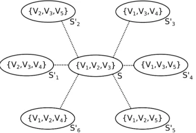
The local search method is based on the concept of neighborhood of a solution which can be defined as follows: given a solution S={Vi1,· · · , Vik}, a neighbor ofS
is a solution S′ where an element of S is replaced by another element not in S. See
Figure 3.3. In each iteration the current solution is replaced by its best neighbor (the one with highest visibility index).
The process of replacing the current solution with its best neighbor is repeated until it is obtained a solution having no better neighbor, which is a local optimum. To simplify the notation, a solution S = {Vi1,· · · , Vik} will be written as
S = {i1,· · · , ik} indicating that the solution is, in fact, correspond to the joint
3. An Improved Parallel Algorithm using GPU for Siting Observers
on Terrain 23
Figure 3.3: Given A = {V1, V2, V3, V4, V5}, S′ are the neighbors of the solution
S ={V1, V2, V3}.
implemented (sequentially) as follows: given the set of candidate viewsheds A =
{V1,· · · , Vn}, let S be a solution composed of k viewsheds, i.e., S = {i1,· · · , ik}
such that the joint viewshed of S is Vi1 ⊕ · · · ⊕Vik where ⊕ represents the union
operation between two viewsheds.
Furthermore, let Vr be the joint viewshed of all viewsheds in S except Vir. In
each iteration, the neighbors of S are generated in order to find the best solution for the next iteration. The visibility indices of the neighbor solutions are calculated by computing the number of visible points in Vr ⊕Vj for r= 1· · ·k and j = 1· · ·n
with j 6=r.
The most time-consuming step in this heuristic is computing the joint vis-ibility index for each neighbor solution. Algorithm 2 presents the code for this step that computes the number of visible points in Vr ⊕Vj (for all r = 1· · ·k and
j = 1· · ·n;j 6= r) and stores them in the element V ix[r][j]. In the next step, this
matrix will be used to find the best neighbor of S.
For efficiency improvement, in this work the viewsheds are packed in 64-bit words (where each word represents the visibility of 64 points). Thus, the viewshed unions and visibility indices can be computed using, respectively, bitwise-or operator and bit population count functions, which are available in the hardware of most current computers.
3.5.2
An Efficient Swap Heuristic Implementation
Notice that, to generate Vr, for r = 1· · ·k, Algorithm 2 performs Θ(k2) union
3. An Improved Parallel Algorithm using GPU for Siting Observers
on Terrain 24
Algorithm 2 Calculate theV ix matrix wherevsize is the number of points in each
viewshed, k is the number of observers in the solution S and n is the number of candidate observers. The output is matrixV ix,whereV ix[r][j]is the joint visibility
index of a solution replacing observer r with j.
1: V ix[k][n]← {{0}}
2: V[k][vsize]← {{0}}
3: for r ←1tok do
4: for m←1to k do
5: if r6=m then
6: for w←1to vsize do
7: V[r][w]← V[r][w] or V[S[m]][w]
8: end for
9: end if
10: end for
11: end for
12: for r ←1tok do
13: for j ←1to n do
14: for w←1to vsize do
15: V ix[r][j]←V ix[r][j] + (V[r][w]orV[j][w])
16: end for
17: end for
18: end for
19: return V ix
matrices. But, as described below, this step can be improved considerably using dynamic programming.
Given a solution S ={i1,· · · , ik}, i.e.,Vi1⊕ · · · ⊕Vik, for each r∈ {1,· · ·, k},
we have Vr = (Vi1 ⊕ · · · ⊕Vir
−1)⊕(Vir+1⊕ · · · ⊕Vik). Doing λ
−
r =Vi1 ⊕ · · · ⊕Vir
−1
and λ+
r =Vir+1⊕ · · · ⊕Vik we can observe that both λ
−
r and λ
+
r can be obtained by
the following recurrence relations:
λ−
1 =∅andλ−r =λ−r−1⊕Vir
−1for all r∈2,· · · , k
λ+k =∅andλ+r =Vir+1⊕λ
+
r+1for all r∈1,· · · , k−1
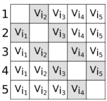
For example, Figure 3.4 illustrates Vr computation for k = 5: in this figure,
each row r represents the value of Vr where the elements in the left of the r-th
column represents λ−
r and in the right, λ
+
r. Notice that λ−4 can be computed by
joining the viewsheds Vi1 and Vi2 (which is the value ofλ−
3) with viewshed Vi3. On
the other hand, the λ+ values can be computed in similar way using the reverse
3. An Improved Parallel Algorithm using GPU for Siting Observers
on Terrain 25
Figure 3.4: Matrix illustrating Vr in a solution with k = 5 observers.
Based on these recurrence relations, Algorithm 3 uses dynamic programming to compute a matrix V that stores Vr, for r = 1· · ·k. Notice that this algorithm
performs only Θ(k)viewshed unions and can replace the piece of code composed by
lines 2 to 11 in Algorithm 2 where are performed Θ(k2
) viewshed unions.
In SiteGSM, the Algorithm 3 was implemented in GPU using the following strategy: the viewsheds were kept in GPU’s global memory and, then, the union of viewsheds (loop in lines 3, 9 and 15 of Algorithm 3) were performed using GPU’s threads, that is, each thread performs a bitwise-or operation with one element of a viewshed and the corresponding element of another viewshed.
Algorithm 3 Compute the matrixV that storesVr, forr= 1· · ·k using a dynamic
programming strategy.
1: V1[k][vsize]← {{0}} 2: for r ←2to k do
3: for w←1 tovsize do
4: V1[r][w]← V1[r−1][w] or V[S[r−1]][w] 5: end for
6: end for
7: V2[k][vsize]← {{0}} 8: for r ←k−1 to 1do
9: for w←1 tovsize do
10: V2[r][w]← V2[r+ 1][w] or V[S[r+ 1]][w] 11: end for
12: end for
13: V[k][vsize]← {{0}}
14: for r ←1to k do
15: for w←1 tovsize do
16: V[r][w]← V1[r][w] or V2[r][w] 17: end for
18: end for
3. An Improved Parallel Algorithm using GPU for Siting Observers
on Terrain 26
neighbor solutions, as performed by lines 12 to 18 in Algorithm 2. A straightforward implementation of this step in GPU was presented in Magalhães et al. [2011a], where all viewsheds are kept in the GPU’s global memory and, then, each element of matrix V ix (that stores the joint visibility index) is computed using a parallel algorithm to overlap a pair of viewsheds followed by a parallel reduction operation to determine the number of visible points. However, this strategy does not take advantage of the GPU performance efficiently because it requires too many accesses to the global memory, which is much slower than other memories such as the shared memory.
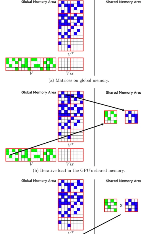
In order to make a better use of the GPU memory hierarchy, we propose a new strategy based on a fast GPU matrix multiplication algorithm. Notice that the joint visibility index, that is, theV ixmatrix, is obtained in lines 12 to 18 of Algorithm 2, where the matrices V and V are overlapped using a bitwise-or operation. In this case, the two matrices are swept in a row major order, but the matrices could be reorganized such that the overlapping could be computed using an access pattern similar to matrix multiplication. More precisely, line 15 in Algorithm 2 can be replaced with
V ix[r][j]←V ix[r][j] +V[r][w] or VT[w][j]
where VT is the transposed matrix ofV.
Thus, the V ix matrix can be computed using a simple adaptation of some very fast algorithm for matrix multiplication in GPU. In particular, we adapted the algorithm presented in NVIDIA [2014], replacing the multiplication operation by a bitwise-or followed by a binary population count operation. This algorithm sub-divides the matrices into blocks, which are loaded iteratively in the GPU’s shared memory as the multiplication process is performed. Figure 3.5 illustrates the algo-rithm: (3.5a) shows the matrices V, VT and V ix in the global memory; in (3.5b),
one block from V and one from VT are loaded in the shared memory and in (3.5c),
the resulting block is written back to the global memory. Therefore, most of the algorithm accesses are to the shared memory which is much faster than the global memory.
3. An Improved Parallel Algorithm using GPU for Siting Observers
on Terrain 27
(a) Matrices on global memory.
(b) Iterative load in the GPU’s shared memory.
(c) Writing back to the global memory.
3. An Improved Parallel Algorithm using GPU for Siting Observers
on Terrain 28
(a) OriginalV matrix.
(b) Mask-matrix overV.
Figure 3.6: The blocks are labeled as following: if all the cells in the block are not visible, the block is labeled with 0; otherwise with 1.
3.6
Experimental Results
The method SiteGSM was implemented in C++/CUDA and compiled using nvcc 4.0 with maximum optimization level (-O3). It was compared againstSiteGPU [Ma-galhães et al., 2011a] and against Site+ [Magalhães et al., 2010], a sequential CPU version with no use of dynamic programming. The tests were executed on a com-puter with Dual Intel Xeon E5-2687 3.1GHz, 128GiB of memory running Ubuntu 12.04 LTS and GPU NVidia Tesla Kepler K20x with 6GiB of global memory, 48KB of shared memory per block and 2688 CUDA processing cores and CUDA 5.0.
The tests used different datasets obtained from NASA SRTM webpage: a terrain with 1201×1201 points (90-meter resolution SRTM3 terrain) representing
a region of the Minas Gerais state in Brazil and another terrain with 3601×3601
points (30-meter resolution SRTM1 terrain) representing a region of the New Jersey state in USA.
The initial set P of candidate observers for each terrain was computed using steps 1 to 3 of the Site method proposed by Franklin [2002] and described in sec-tion 3.4. The Site was set up to select 1000 candidates for the smaller terrain and 3000 candidates for the larger one, as in Magalhães et al. [2011a]. Also, the
view-sheds of all candidate observers were computed using the same viewshed algorithm used bySite, with the observers and target points sited 30 meters above the terrain. This value was chosen because, in general, it is the height of real towers, as for example, communication antennas [Delmellea et al., 2005].
3. An Improved Parallel Algorithm using GPU for Siting Observers
on Terrain 29
300 points for the first terrain; and 200, 300 and 400 points for the second terrain. For each terrain, the desired coverages (joint visibility indices) were 75%, 85% and
95% of the terrain area. Figure 3.7 shows three examples, with radii of interest100, 200 and 300 and desired coverage of 25%, indicating how observers were sited on
the terrain.
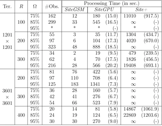
Table 3.1 presents the processing time (in seconds) spent by each method. Column #Obs shows the number of observers sited in each case and the SiteGSM’s speedup is shown in parentheses. The symbol * represents a case for which the set
P of candidate observers is not enough to achieve the desired coverage. The symbol
∞ indicates those cases where the processing time is greater than 7 hours.
As the tests showed, in all cases, the methodSiteGSM proposed in this paper was faster than SiteGPU [Magalhães et al., 2011a] - in some cases, more than 20 times - and, as expected, much faster than theSite+(more than 1200 times). Notice that, in almost all cases, the higher the desired coverage, the higher the speedup. This can be explained by the fact that higher coverages require more observers and consequently more viewsheds must be processed.
While much faster than Site+, SiteGSM obtains the same solution as the former and, as presented in Magalhães et al. [2010], the Site+ can achieve similar terrain coverage as the original Site using about 10% less observers. This can be an important (economic) improvement since the observers can represent some expensive facility, as for example, a communication antenna.
3.7
Conclusion
We presented an efficient implementation of a heuristic to site observers on terrains to achieve a given coverage of this terrain. The method is based on an extension of Site [Franklin, 2002], where it was included a local search strategy that tries to improve the coverage obtained by a fixed number of observers. This local search was implemented in parallel using graphics processing units and also dynamic pro-gramming.
As the tests showed, the method described in this paper is more efficient than a previous method presented in Magalhães et al. [2011a] and, in some cases, more than 20 times faster. Also, it is up to 1200 times faster than the corresponding sequential implementation.
3. An Improved Parallel Algorithm using GPU for Siting Observers
on Terrain 30
Figure 3.7: Observers sited in terrain 1201x1201 with desired coverage 25% and
radii of interest: 100(a), 200(b) and300 (c). The observers are indicated by yellow triangles and visible points are showed in red.
than the original Site and thus, better solutions can be generated faster.
3. An Improved Parallel Algorithm using GPU for Siting Observers
on Terrain 31
Table 3.1: Processing time (in seconds) of three methods: two parallel methods using GPU (SiteGSM and SiteGPU) and a sequential one (Site+) to site observers on terrains with different sizes considering different radii of interest (R) to achieve some desired coverages (Ω).
Ter. R Ω #Obs. Processing Time (in sec.)
SiteGSM SiteGPU Site+
1201
×
1201
100 75%85% 162299 1233 180 (15.0) 11010545 (16.5) ∞ (917.5)(-)
95% * * * (-) * (-)
200 75%85% 5597 36 104 (17.3)35 (11.7) 13044020 (434.7)(670.0)
95% 323 48 888 (18.5) ∞ (-)
300 75%85% 3462 24 1970 (17.5)(9.5) 1826479 (239.5)(456.5) 95% 216 28 566 (20.2) 19408 (693.1)
3601
×
3601
200
75% 81 76 422 (5.6) ∞ (-)
85% 97 110 708 (6.4) ∞ (-)
95% 125 183 1341 (7.3) ∞ (-)
300
75% 36 28 160 (5.7) ∞ (-)
85% 42 41 276 (6.7) ∞ (-)
95% 54 66 523 (7.9) ∞ (-)
400
75% 20 14 81 (5.8) 14867 (1061.9) 85% 24 19 124 (6.5) 22869 (1203.6)
![Figura 1.1: Tipos de amostragem de pontos e formas de representação de MDEs. Fonte: [Câmara et al., 2001]](https://thumb-eu.123doks.com/thumbv2/123dok_br/15385477.66881/16.892.173.841.224.712/figura-tipos-amostragem-pontos-formas-representação-fonte-câmara.webp)


![Figure 3.2: Comparison between GPUs and CPUs structures. Source: [NVIDIA, 2014]](https://thumb-eu.123doks.com/thumbv2/123dok_br/15385477.66881/33.892.293.673.274.410/figure-comparison-gpus-cpus-structures-source-nvidia.webp)