THE STRUCTURAL GEOGRAPHIC COMPONENTS
OF A TERRITORIAL SURVEY
POMPEI COCEAN
∗∗∗∗ABSTRACT - When using regional geographic approaches, i.e. when applying its concepts to the
problems of anthropic communities from a certain territory, is compulsory. In this study we have taken into account the complex and the etymologically adequate meaning of the notion and not the meaning most commonly used at present (i.e. the functional zoning and regionalisation of the territory). Relying on the estimations of territorial surveys, one may give the solutions for the extant malfunctions and for optimising future developments. The geographic components of this parameter (the territorial survey) are: the natural support basis, the population and its settlements, the social and economic development level, the technical equipment of the territory, and the extant risks and malfunctions. Indices from 1 to 10 will be summed in order to give us the big picture, namely the present-day situation and the favourability level of that territory for various anthropic interventions.
Key words: territorial survey, natural support basis, the technical infrastructure of the territory,
resilience, geographic components.
In the context of Romania’s interest in EU accession, territorial planning and arrangement is an important issue because of the difference in development level between our country and the other partner states. The absorption of EU funds that Romania is so much in need of is inconceivable (because to the great sums) without consistent regional and local development programmes targeting the technical infrastructure of the territory, the economic branches, the social, and the environmental aspects. This is why new commands appear in the field of geographic research as well as new opportunities that we should not lose but capitalise at their potential.
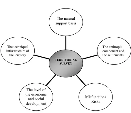
Therefore, the estimation of the territorial survey becomes a priority for any analysis. If we ignore it, development strategies remain uncertain. From the beginning we claim that our approach uses another meaning of territorial survey, a meaning that is not very much used at present (i.e. functional zoning and regionalisation of the territory). In this study we have taken into account the complex and etymologically adequate meaning which is richer and encapsulates both the catalysing and the inhibitive, restrictive components of the given area in the same equation. The result is the rigorous territorial survey. The estimation of the territorial survey is rather difficult because certain territorial features cannot be quantified, and in the case of certain quantifiable elements, several situations appear when approximations prevail (e.g. soil fertility, quality of the forest cover, the tourist appeal of certain spots). Despite these difficulties which we have overcome by comparing the area under scrutiny with other areas (e.g. as a sample case study, we have chosen the periurban zone of the municipality of BistriŃa), we believe that we can estimate the territorial survey starting from the following factors of the zone (Figure 1):
- The natural support basis
- The anthropic component and the settlements - The level of economic and social development - The equipment of the territory
- The existent malfunctions and risks
∗ “Babe -Bolyai” University, Department of Regional Geography, Faculty of Geography, Clinicilor Street, no. 5-7, 400006 Cluj-Napoca, Romania.
Fig. 1. The structural components of the territorial survey.
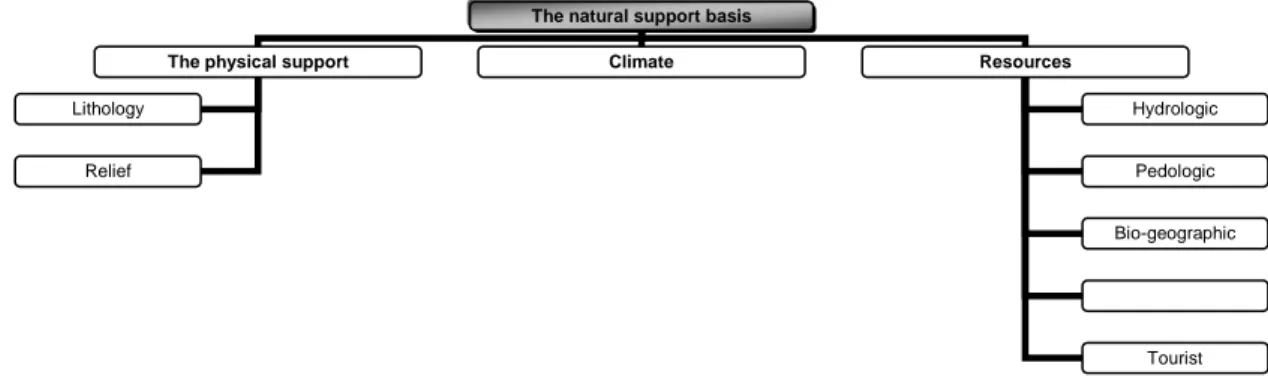
When defining the territorial survey, the natural support basis is represented by the following three factors: the features of the physical support (lithology and relief), the climatic peculiarities (with a decisive influence upon the circumstances of anthropic activities), and the quantity and the quality of resources (the hydrologic, soil, bio-geographic, crust and tourist resources as elements necessary for inhabiting and developing the territory) (Figure 2).
The geologic structure and the relief influence the territorial survey according to the favourability level for building habitats, the technical infrastructure of the territory and the development of agricultural, tourist activities, and forestry. On a scale from 1 to 10, diverse areas may occupy the most varied positions. The areas located on the old crystalline and very levelled support or those from the wide plains characterised by low relief energy and minimum fragmentation have higher values (7-10), whereas the highly fragmented surface on an unstable geologic support with intense and active geomorphologic processes will have lower values (1-4). It is here that the most threatened and at risks areas may be identified. They are affected by landslides, torrents, suffusion, and creep, etc. These processes are frequent on soft (sand, marl, argyle, loess) or soluble (limestone, gypsum, salt) sedimentary rocks. (A major distortion may be caused by the seismic activity. The frequency and the intensity of earthquakes can diminish the favourability level of the physical support a lot). In most cases, the levelled and a little slant areas from the fields, low-altitude hills, river meadows, and basins (depressions) offer good environmental conditions for the technical infrastructure and buildings, as well as for efficient agricultural activities. Similarly, the slopes and the levelled hills and mountaintops become productive for the pastoral economy, fruit growing, woods, and sightseeing tourism.
The climate ensures the environment, the “atmosphere” for any anthropic activity, while in certain
fields, such as tourism, it is a real economic and socially exploited resource. Of course, its extreme manifestations (temperature, rainfall, and wind) are responsible for many problems in the relation between man and the territory. Sometimes they diminish significantly the extent to which the territory is inhabited (i.e. the unpopulated or low-populated spaces). As Romania has a typical continental climate, the global favourability level of the climate is high. On the same scale, it has high values (+ 7). Neither long droughts when days are hot and the temperature is above 30º C, nor long frosty periods with temperatures below -15ºC are frequent. These values are much higher in depressions and valley corridors where there is an obvious “shelter” climate and the meteorological parameters are milder. The opening of depressions prevents, in most cases, thermal inversions and the “lakes of frost” during the cold period of the year. The rainfall values in the hilly and mountainous areas (600-1,200 mm) are enough to ensure a positive hydrologic balance in
The techniqual infrastructure of
the territory
The level of the economic
and social development
Misfunctions Risks
The anthropic component and the settlements
The natural support basis
agriculture, without affecting, due to nebulosity, the long periods of good weather (1,800-1,900 hours/year). This has a positive impact on most anthropic activities (agriculture, tourism, and forestry).
Nevertheless, the climatic changes have seemed to pose problems lately. In 2005 the highest rainfall values were registered: up to 150 l/m² in 24 hours. The quantity of rainfall caused six waves of floods that affected almost all the regions of Romania. In this context, the favourability level obviously decreases, firstly because of the associated phenomena (floods, landslides).
Fig. 2. The main elements of the support basis analysed in the territorial survey.
Resources are a sine qua non condition for the development of any territory. They have extremely
diverse origins and forms of manifestation and storage. They can be hydrologic and biogeographic, crust and tourist resources. The chance of any territory is to have resources. If territories don’t have resources, they have to be fetched from outside at higher costs. Hydrologic resources include, first of all, the drinking water, compulsory for anthropic consumption and animal breeding, and also for other economic activities. Higher living standards are conditioned, up to a level, by higher water consumption. Surface hydrologic networks with big flows or large phreatic accumulations become a factor favourable for inhabiting that territory. Of great importance is not only the quantity, but also the quality of water. The indices for this resource will take both aspects into account. Among the hydrologic resources one also includes mineral and thermal waters which also have a well-known tourist role.
The pedologic resources are made of different soil classes, soil types and sub-types. When estimating the territorial survey, fertility is the main feature taken into account. The structure, the composition and the fertility of the soil are decisive in efficient agriculture, in developing great productivity vegetal arrangements. The mollisol and the river meadow alluvial soils are estimated better, while the degraded, poor-quality, low-structured soils with little humus will be estimated accordingly. A territory’s soil variety whose fertility is higher than the average values is an optimal element for ample agricultural use.
Although the importance of the vegetation and the fauna from biogeographic resources have diminished since prehistory as far as the humanisation space is concerned, they are still important for contemporary development. Forests create industry and give firewood. They also have well-known tourist and protection functions. The spatial extension and the consistency of the forests should be evaluated in the same manner: from the higher values characteristic of the densely forested areas down to the lower levels characteristic of the forest-steppe and the steppe. The fauna is both a landscape element and an important tourist or economic resource.
Most of our attention should be paid to the crust resources: from energetic or metallurgic resources to those necessary for chemical industry and the construction materials. Their diversity and abundance is a decisive factor for territorial development and should be taken into account in the spatial survey. As raw materials, the crust resources are a key-factor in the development of many industrial branches. There are also other industrial branches which are dependent on the former (the machine industry).
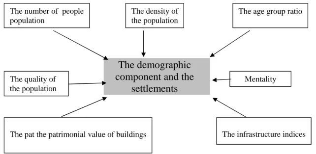
The demographic and the habitat component is significant for the survey as it reveals the dimension
and the possibilities of the intervention factor, as well as the result of its action in time due to a certain “dowry” of that space. Its main components are: the number of the people and the density of the population,
The natural support basis
The physical support Climate Resources
Lithology
Relief
Hydrologic
Pedologic
Bio-geographic
the age group ratio, the professional quality of the population, its mentality, the patrimonial value of buildings, and the settlements’ infrastructure (including social services) (Figure 3).
The number of the people in a territory is an important element in the survey as it shows the
quantitative aspect of the intervention factor and of the factor whose desiderata should be accomplished during the development process. Similarly, the density of the population offers precise clues about the pressure upon the natural support basis, the need for resources, and the territorial infrastructure.
Fig. 3. The main elements of the anthropic component in a territorial survey.
Although the population’s ageing is being noticed in Romania and Europe, in several areas it is quite low, unlike other areas. A reservoir of young population is located in the most rural areas whose poles are small and medium-size towns. It is the case of the following towns: BistriŃa, Alba Iulia, and Zalău, where a segment of the young population is outside their own periurban zone. This young population can ensure the demographic balance and the maintenance of a natural output higher than the average value in Romania. Relying on the age pyramid and prognosis, detailed studies should point to the short-term, medium-term, and long-term demographic trends. Thus, an accurate correlation can be made between the evolution of the human resource and the evolution of the whole territory.
The quality of the population is also an optimal element given both by education – obvious, mostly,
in the urban area – and the accumulation in time of a rich experience in agriculture and forestry, as is the case in the rural area (e.g. the positive influence of the Saxons living in Transylvania in the town of BistriŃa and its surroundings).
The demographic potential, frequently known under the name of human resource, is also
qualitatively defined by mentality, which was modelled in time and is now presented as traditions, customs, occupations, and folklore. A hardworking people’s mentality, people who are honest, inventive and dynamic, with a winner’s mentality, and a strong attachment to their place, all these become a significant asset in the development and the cohesion of the territorial system, no matter where it is located.
The patrimonial value of buildings quantifies the values involved in the structure, the composition
and the functions of settlements. These are public and private buildings with historical, religious, cultural, tourist, political, and administrative functions, buildings of social interest or whose function is to shelter the population of the territory under survey. The quality, the state and the adequacy of those buildings for a kind of exploitation as diverse and as efficient as possible, these are the territorial evaluator’s precise target.
The social infrastructure of the territory includes the totality of the institutions, the edifices and the
accessories used in order to fulfil the population’s social desiderata (education, health protection, culture, creeds, and social protection). Obviously, all these cannot be taken into consideration without their specialised staff.
The level of economic and social development of the territory under survey may be compared to the
level of similar territorial entities (areas, zones, and regions), the level of the entire country, or, at a higher
The demographic
component and the
settlements
The number of peoplepopulation
The density of the population
The age group ratio
The quality of the population
Mentality
The economic component is the result of the complex and long interaction between the population and the
physical component of the territory. It usually is an inherited feature whose contribution should be quantified and whose negative impact evaluated by future approaches. Both hypostases of this component become sine
qua non conditions for the development process, the economy being responsible for ensuring the subsistence
means and the living standards of the population. For each territory, according to its natural resources, traditions in putting resources into use, perspectives, we should analyse and quantify the following aspects with a view to their contribution to the global estimation of the territorial potential: agriculture, industry, forestry, tourism, trade and services (or several other branches characteristic of that territory, such as fishery, transportation, quaternary sector of industry, etc.).
For instance, the periurban zone of BistriŃa is average-low in comparison with other periurban zones as its territory is positioned within the lower third section of the appreciation scale (index 4,0). This is why it is surpassed by most periurban zones of Romania’s county cities. The synthetic analysis of its major economic branches reveals the following aspects:
- Its industry is located mainly in the polarising centre (the municipality of BistriŃa) and it has a relatively small number of branches (manufacturing batteries and car radiators, electric cables, pipes and PVC tubes, glass, furniture; meat and milk industry) and its production capacity (but for Rombat Company) is low or average;
- Agriculture has average crops, its intensity is low, but for the orchards (most of them were destroyed after 1990). The agricultural business, i.e. the integrated highly productive agriculture is only at its beginning;
- Tourism is not yet a complementary alternative for rural development. Tourism is practised either because of the inertia resulting from the absence of any action part of a regional, zonal or local development strategy (set forth in the PATR);
- Trade is more intense and, thus, the main feature of the economy of the periurban zone is the appearance of a service economy although its infrastructure is still inadequate, in many cases.
Taking all these into account, we conclude that the level of social and economic development represents the starting line, the fundamental basis of any initiative to promote the remodelling of the area, wherever it may come from: the governmental, the regional, or the local level. The development level defines, among others, the resilience of the territorial system (its adaptation and persistence capacity), the market characteristics, the opportunities and the risks for the future initiatives. The low value of the components of this territorial survey criterion directly influences the final estimation.
The technical infrastructure of the territory is like the circulatory system in the human body: it
moves the mass, the energy, the capital, and the interest towards all the capillaries. The quantitative and the qualitative insufficiency or the precarious state of the infrastructure components (roads, railways, airports, etc., the existence of indoor plumbing and sewerage system, the natural gas heating systems, and telecommunications) determine a difficult, interrupted drainage, with numerous thresholds and inflexion spots characterised by the modulation of the compulsory principles for development previously mentioned. Moreover, their absence may redirect the flux towards other better-equipped periurban zones. From this point of view, the periurban zone of BistriŃa, which is the sample of this study, has a low-level support capacity. This calls for rapid and massive intervention in order to improve the situation. If no action is taken, this periurban zone will evolve slowly, at random, and will lose the competition with other periurban zones. And last but not least, it will lose the competition with itself.
The periurban zone of BistriŃa is below the average appreciation scale (4,0) as far as the technical infrastructure of the territory is concerned. This is because of the low modernisation of the road system (including also the Cluj-Napoca-BistriŃa-Vatra-Dornei-Suceava national road), the absence of the surrounding road belt of BistriŃa, and its position distanced from the Bucure ti-SărăŃel-Baia-Mare main railway (this is situated at about 20 km from the extreme settlements of the zone – Tărpiu, Dumitra, Cu ma, etc.). In addition, the closest airport is in Târgu Mure , more than 80 km away. The settlements of this zone (except those integrated into the municipality, from the administrative point of view) do not have any indoor plumbing system or any sewerage system, and the access to mobile telephone connections is deficient because there are a lot of areas where the connection is “shadowed”.
The malfunctions and risks of any area diminish favourability and worsen the territorial survey
invariable effect is lower survey values. They are either the “product” of the unexpected intervention of natural factors or, especially, the result of the ill-oriented, unfinished or inadequate anthropic action (as compared to the new evolutionary trends of the territorial system). They belong to the anthropic desiderata influenced by what it is and what it should be.
Malfunctions and risks define, in their own way, an intervention, the negative manifestation of the economic and environmental components. Whereas risks may have a double origin: natural (morphologic, climatic, hydrologic, biogeographic) or anthropic (technological, pollution), malfunctions are mainly caused by the uncontrolled, abusive, and inadequate anthropic action upon the environment and its components. They appear at the level of the interrelations between certain structural territorial components and also within the same component at any of its levels. Their removal may require great effort and, as a result, it diminishes the competitiveness index of the territory under scrutiny as compared with other territorial entities.
In addition to the above-mentioned criteria, one has to take into account the geographic location of
the territory under study when defining its relations with similar neighbouring entities. From this point of
view, BistriŃa and its periurban zone is favourable. It has a wide “hinterland”, without any other competing pole in the near future. Moreover, its location on the axis of the future highway to Moldavia (according to
PATR, Planul de Amenajare a Teritoriului Regiunii de Nord-Vest/ The Sketch for the Territorial Planning of the North-West Region, 2004 or according to PATZ, Planul de Amenajare a Teritoriului Zonal-periurbanul municipiului BistriŃa/ The Sketch for the Territorial Planning of the Periurban Zone of the Municipality of BistriŃa, 2005) gives it several geospatial attributes.
Summing up the values of these five factors with a decisive impact upon the territorial survey we have noticed that the periurban zone of BistriŃa creates a favourable potential for development and opportunities. These factors should be “accessed” and oriented according to the competitive advantage principle towards a higher economic and social level.
REFERENCES
ANTONESCU DANIELA (2003), Dezvoltarea regională în România, Editura Oscar Print, Bucure ti.
BAILLY A. S. (1991), Les concepts de la géographie humaine, Masson, Paris.
BENEDEK J. (2000), Organizarea spaŃiului rural în zona de influenŃă apropiată a ora ulkui BistriŃa, Edit.
Presa Universitară Clujeană, Cluj-Napoca.
BOLD I. and CRĂCIUN A. (1999) Organizarea teritoriului. Edit. Mirton, Timi oara.
CHORLEY R. J. and HAGGETT P. (1968), Socio-Economic Models in Geography, Methuen, London. CHRISTALLER W. (1966), Central Places in Southern Germany (translated by C. Baskin), Englewood
Cliffs, New York, Biblioteca Univ. Leicester.
COCEAN P. (2004- Co-ordinator), Planul de Amenajare a Teritoriului Regiunii de Nord-Vest. Coordonate
majore, Editura Presa Universitară Clujeană, Cluj-Napoca.
COCEAN P. (2005), Geografie Regională, Edit. Presa Universitară Clujeană, Cluj-Napoca. DENEKE D. and GARETH S. (1988), Urban Expansion, Planning, vol. 3.
FELMANN J., GETIS A. and GETIS J. (1990), Human Geography, Wm. C. Brown Publishers. GUSTI G. (1974), Forme noi de a ezare, Ed. Tehnică, Bucure ti.
HALL P. (1999), Ora ele de mâine. O istorie intelectuală a urbanismului în secolul XX, Edit. All, Bucure ti.
IANOS I. (1987), Ora ele i organizarea spaŃiului geografic, Edit. Academiei R.S.R., Bucure ti.
IANO I. and J-B. HUMEAU (2000), Teoria sistemelor de a ezări umane, Edit. Tehnică, Bucure ti. JOHNSON J. H. (1967), Urban Geography, Pergamon Press.
LAJUGIE J., DELFAUD P.,LACOUR C. (1985), Espace regional et amenagement du terittoire,Dalloz, Paris. LĂZĂRESCU C. (1977), Urbanismul în România, Edit. Tehnică, Bucure ti.
LÖSCH A. (1954), The Economics of Location, Yale University Press, New Haven,
MATEI I. and MIHĂILESCU I. (1985), Satul românesc. Studii, Edit. Academiei R.S.R., Bucure ti.
MAYHEW SUSAN (1997), Oxford Dictionary of Geography, Second edit. Oxford University Press, Oxford. MĂNESCU LUCREłIA (1999), Ora ul Buzău i zona sa de influenŃă, Edit. Univ. Bucure ti.
SMITH D. M. (1975), Industrial Location. An Economic Geographical Analysis, John Wiley and Sons, NY, London, Sydney, Toronto.
WAUGH D. (2000), Geography. An Integrated Approach. Third Edit., Nelson, Mayfield Road, Surrey, U.K.