THE IMPACT OF MINING ACTIVITY UPON THE AQUATIC
ENVIRONMENT IN THE SOUTHERN APUSENI MOUNTAINS
SIGISMUND DUMA
1ABSTRACT - In the Southern Apuseni Mountains, mining activities have taken place since Antiquity,
leaving their marks upon the natural environment, the aquatic one inclusively. If the traditional technologies had a low impact upon the aquatic environment, the ones in the modern period have affected it up to the “dead water” level. It is about the disorganization of the hydrographical basins and especially about aggressive pollution of surface waters with some of the most toxic chemical substances such as cyanides, as well as by an increase in the contents of metallic ions, chlorides, sulphides, sulphates, suspensions and fixed residuum. The decrease in pH, and implicitly the acidification of waters, is also remarkable.
It must be mentioned that no systematic studies of the impact of mining activities upon the aquatic environment have been conducted in the area in the last years. In these conditions, the data about water quality have been taken over from the studies conducted by author between 1996 and 1998. The cause of the lack of concern in the field is no other but the cease in ore valorization activities in the majority of the mining objectives in the area. As none of the tailings settling ponds has guard canals, the direct pluvial waters and the ones drained from the slopes transport tailings with noxes which they subsequently discharge in the local pluvial network. In these conditions, both the quality of the mine waters which run freely into the emissary and of the ones that flow from the waste dumps remain mainly in the qualitative parameters analyzed and presented in the study.
Key words: the Southern Apuseni Mountains, mining activity, water pollution, risk, ecological
rehabilitation.
1. SHORT DESCRIPTION OF THE HYDROGRAPHIC NETWORK
The analyzed territory is crossed by a dense network of fluvial courses which belong to the western group of rivers. As regards the density of the hydrographic network, it maintains at values of generally more than 0.8–1.0 km/km2, with evident altitudinal oscillations. The highest densities appear at 1200–1400m high, at the level where the heaviest pluvial supply has a maximum frequency. Over 1400m, where the altitudinal nival supply begins to dominate and where the weathering processes intensify, the density begins to decrease. The decrease in density of the fluvial network at the subalpine level is due to the long freezing period, more than 150 days annually, as well as to the watershed effect, where the lack of a permanent runoff stream network is felt. The snow layer, which maintains itself six-seven months per year, has a protective role upon the relief, the runoff generated by its melting being of low intensity. In the lower areas, the slope deposits layer thickens sensibly and the heavy rains contribute to an intense fragmentation of the relief and, of course, to the creation of a dense running water network. The mantle-rock and the fissures in the parent rocks contain abundant phreatic waters which assure permanent underground supply even for the small rivers (Duma, S., 1998).
The running waters in the Southern Apuseni Mountains are included in the fluvial system of the Mure and of the Cri ul Alb (Fig. 1.), both of them discharging their waters into the Tisa and implicitly into the Danube.
The Mure River, the longest of the inner rivers (761 km), is the main collector of the waters in the studied region. Moreover, the Southern Apuseni Mountains are also called the Mure Mountains, especially because the river borders their eastern and southern side.
1 Professor, Ph.D., "Traian" Ecological University of Deva, Romania.
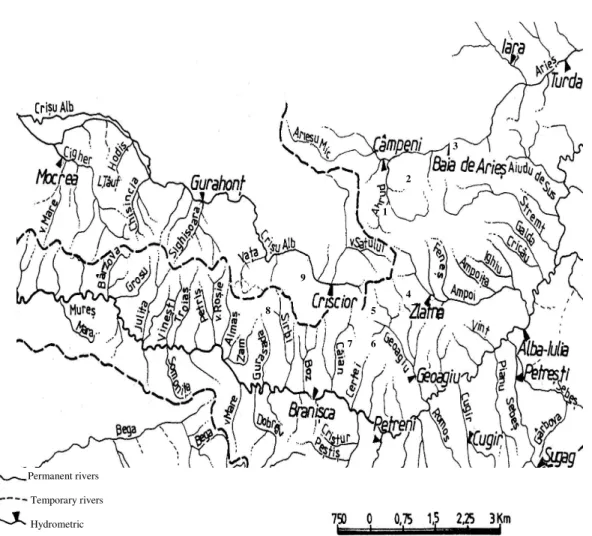
Figure 1.Hydrographic network in the Southern Apuseni Mountains.
The Mure has its origin in the Giurgeu Depression, at an altitude of 1,275m, the difference of altitude between its origin and its exit from the country being of 1193m. It has a mean slope of 1% and a sinuosity coefficient of 1.97, while the mean altitude of its hydrographic basin is of 613m. The mean discharge has an increasing dynamics from 9.87 m3/s at TopliŃa hydrographic post to 103.2 m3/s at Alba Iulia post. This increase is a result of the water share brought by its tributaries the Arie , Ampoi, Niraj, Târnava Mare and Târnava Mică rivers. From Alba Iulia up to its exit from the country, the Mure receives its left-bank tributaries: the Sebe , Cugir, Oră tie, Strei, Cerna and Dobra, and the right-bank ones: the Geoagiu, the Certej and the Căian, as well as other rivers of smaller dimensions, so that, at Brăni ca post, it registers a discharge of 147 m3/s and at Arad of 157 m3/s. On the Mure , the 1970 and the 1975 catastrophic discharges are known. In 1970, the maximum discharges of 2600 m3/s and of 2180 m3/s were registered at Alba Iulia and at Arad, respectively (Duma, S., 1998).
The main tributaries of the Mure , from the Southern Apuseni, are the Arie , the Ampoi and the Geoagiu.
The Arie (Area = 3,005km2; Length = 166km; Altitude of the river source = 1,108m; Altitude of the river mouth = 264m; Perimeter = 5m/km) crosses the massif on a distance of 30 km, forming four defiles between Sălciua and Lunca, one upstream the confluence with the Ocoli , another one downstream Lunge ti and the last one between Buru and Moldovene ti. In this place, a water aeration threshold was constructed (Fig. 2). At Moldovene ti, the river exits the defile, the valley widens suddenly and the slope begins to decrease gradually. At Turda, the river has a mean annual discharge of 26 mc/s. Downstream Abrud, the Arie receives, from the Metaliferi Mountains, a series of
right-Permanent rivers
Temporary rivers
Hydrometric stations
1-9 Zones of taking and analyzing water samples; 1- Ro ia Montană; 2- Ro ia Poieni; 3- Baia de Arie ; 4- Larga Mine; 5- Hane Mine, 6- Certej- Săcărâmb, 7- TroiŃa Mine, 8- VorŃa Mine; 9- Barza- Brad.
2 3
4 5
6 7 9
8
bank small rills such as the tefanca, the Mu ca, the Se ei, which receive the waters from the Ro ia Poieni, Hermăneasa and Cioara mining perimeter. The last flows into the Arie next to the Baia de Arie exploitation. A little downstream, at Sălciua de Jos, the Pârâul Huzii flows into the Arie , as well as the Valea Morilor which flows at the contact of the Metaliferi Mountains with the Bedeleu Massif of the Trascău Mountains. The Abrud (Area = 229 km2; Length = 22 km) is the most important right-bank tributary of the Arie and is received at Câmpeni. It gathers the rills that flow radially around the igneous massif of Detunata, well-known for its basaltic columns. The Valea Cornii and the Valea Ro iei are among the most important tributaries of the Abrud, receiving the waters from the Ro ia Montană mining perimeter.
Figure 2.The Arie River – water aeration threshold at Moldovene ti.
The Ampoi (Area = 579 km2, Length = 57km, Altitude of the river source = 1,060m, Altitude of the river mouth = 219m, Perimeter = 15m/km) is an important right-bank tributary of the Mure , receiving waters from the Trascău Mountains and from the Metaliferi Mountains and discharging them next to the city of Alba Iulia. It originates at the foot of the Dealul Mare, has a mean runoff gradient of 20–30 m/km and a relatively small hydrographic basin. Its mean discharges are of 1.33 mc/s at Zlatna and of 4.26 mc/s at BărăbanŃ. Crossing different types of rocks, the river has eroded selectively, generating sectors widened in the soft rocks (Zlatna, Poiana Ampoiului, Mete , TăuŃi, AmpoiŃa, ard) separated by narrower corridors digged into ophiolites, conglomerates, or limestone. It has as left-bank tributaries: the Vâltori (Area = 41 km2; Length = 12 km), the Fene (Area = 61 km2; Length = 16 km), the AmpoiŃa (Area = 54 km2; Length = 15 km) and the Ighiu (Area = 52 km2; Length = 17 km). On the right bank, it receives the Valea Largă, which collects the waters from the Valea Largă Mine, the Trâmpoiele and the GalaŃi valleys, etc.
Glod, the Jurassic limestone core appears, cut perpendicularly by the Valea Glodului and then, by the Geoagiu, downstream Bal a. Among the right-bank tributaries, the Pârâul Porcului, the Gura Văii and the Valea Ro ie have small dimensions, while the left-bank ones deserve to be mentioned: the Techereu, the Almă el, which collects the waters from the Hane Mine, and the Ardeu (Area = 51 km2; Length = 23 km).
The smaller, direct tributaries of the Mure , flowing from the Southern Apuseni, upstream Alba Iulia, are the following: the Aiud (Area = 182 km2, Length = 26km, Altitude of the river source = 907m, Altitude of the river mouth = 241m, Perimeter = 25m/km), theRâmeŃ (Area = 229 km2, Length = 48km) and the Galda (Area = 250 km2, Length = 39km, Altitude of the river source = 1,120m, Altitude of the river mouth = 225m, Perimeter = 21m/km) from the Trascău Mountains, and downstream Alba Iulia: the VinŃ (Area = 30 km2; Length = 12km), the Blandiana (Area = 31 km2; Length = 11 km), the BăcăinŃi (Area = 54 km2; Length = 15km), theHomorod (Area = 32 km2; Length
= 13km), the Boholt, the Certej, the Căian from the Metaliferi Mountains. From the Zarand Mountains, it collects the waters of the Boz, Sârbi, VorŃa, Gurasada, Alma , Troia , JuliŃa, Bârzava, Milova rivers, etc.
The Cri ul Alb (Area = 4,240 km², Length = 234km, Altitude of the river source = 1,000m, Altitude of the river mouth = 87m, Perimeter = 41m/km), the main collector of the waters in the northern sector of the Metaliferi-Zarand Mountains, has a vigorous and picturesque course in this region, with numerous gorges and knicks. At Criscior, after 31 km from its source, the river descends to altitudes under 300m and receives the left-bank waters from the Valea Arsului opencast pit and at Brad the ones of the Luncoi and the ones from the Barza Mine. From this place to Ineu, on a length of 150km, the stream has an altitude fall of 187m and a gradient of 1.2m/km. In the GurahonŃ Depression, the river gradient decreases under 1.0 m/km, producing strong braiding, then it deepens again in the eruptive, at Cociuba. Downstream this last narrowing, the river enters the gulf of Zarand, where the valley widens, receiving the aspect of alluvial plain. The first important tributary (the Valea Satului) is collected by the upper Cri ul Alb on the left, having dimensions similar to the collector (Area = 107km2; Length = 15 km). The rest of the left-bank tributaries, received from the Metaliferi and the Zarand Mountains, have similar dimensions: the Bucuresci (Area = 80 km2; Length = 14km), the Luncoi (Area = 74 km2; Length = 10km), the VaŃa (Area = 87 km2; Length = 21km), the Sighi oara (Area = 156 km2; Length = 16km), the Chi india (Area = 102 km2; Length = 20km). Downstream, there are a series of smaller rills (the Cleceova, Hodi , Potoc and Gutul) and then, the most important hydrographic system in Zarand: the Cigher (Area = 670 km2; Length = 58 km). Excepting the Cigher, all these rills flow into the Canalul Morilor, from where it discharges through outlets in the Cri ul Alb.
In the analyzed region, there are also a series of natural and artificial lakes. The natural lakes are genetically integrated into the karst type, such as Lake Ighiu (Area = 5.26 ha; Hmax = 9m), which is situated on the valley bearing the same name, in the southern part of the Trascău Mountains. This is the most typical dolina karst lake in Romania. Its morphobathymetric profile is typical for steep-slope dolinas. The maximum depth is registered in the whirlpool area, in the place where waters flow towards the lake emissary. The hydric regime is equilibrated due to the permanent and rich share brought by springs and by the slope runoff.
In the same region, there are also two storage lakes for mining and recreation needs (Făerag, in the proximity of Deva, on the Certej Valley, and Caraciu, in the homonymous volcanic massif near Brad). In the Zarand Mountains, the TăuŃ reservoir was built on the Cigher (Area = 240ha), with the purpose of controlling floods in the depression.
2. DEGRADATION OF HYDROGRAPHIC BASINS AND WATER POLLUTION
THROUGH THE ORE EXPLOITATION AND PROCESSING ACTIVITIES
Through their specificity, ore exploitation and processing activities induce the systemic disorder state to the aquatic environment. This appears in the degradation of the hydrographic basins and in water pollution. The degradation of hydrographic basins implies their disorganization through excavations, stream blocking, water flowing underground, and through the acceleration of the sheet and the gully erosion. Water pollution appears as result of the introduction of noxious elements such as cyanides, metallic ions, chlorides, sulphates, etc. in the aquatic environment, as well as through the modification of pH (water acidification) and the increase in alluvial discharge.
As each hydrographic basin has its characteristics (area, discharge, hydric regime, gradient, etc.), as well as a certain peculiarity regarding the degradation and the pollution level, we found useful the presentation of these phenomena on hydrographic basins and on river groups.
2.1. Degradation of hydrographic basins and water pollution in the Arie basin
The degradation and the pollution sources of the aquatic environment in the Arie basin proceed from the mining objectives of Ro ia Montană, Ro ia Poieni and Baia de Arie .
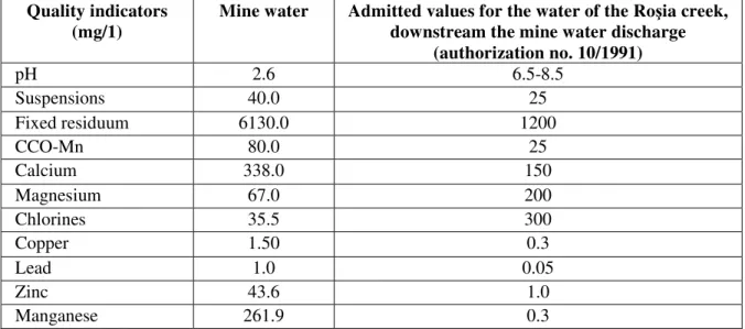
The main water collector within the Ro ia Montană mining perimeter is the Valea Ro iei creek, in whose retention basin the Cetate opencast pit is also situated; within its area, the hydrographic network has been totally disorganized. From the opencast pit, the pluvial waters infiltrate into underground through the old mining works, washing this way the mineralization. They are collected at the level of the transport gallery from where they are discharged into the Valea Ro iei creek.
In the mine waters, exceeding values are registered for almost all indicators, including very noxious elements such as lead, copper, zinc and manganese, the pH level being very low (Table 1).
Table 1.Water quality in the Cetate Mine (Ro ia Montană).
Quality indicators (mg/1)
Mine water Admitted values for the water of the Ro ia creek, downstream the mine water discharge
(authorization no. 10/1991)
pH 2.6 6.5-8.5
Suspensions 40.0 25
Fixed residuum 6130.0 1200
CCO-Mn 80.0 25
Calcium 338.0 150
Magnesium 67.0 200
Chlorines 35.5 300
Copper 1.50 0.3
Lead 1.0 0.05
Zinc 43.6 1.0
Manganese 261.9 0.3
Industrial water for the Gura Ro iei ore processing plant has been taken from the Abrud River through a water inlet placed 300 m upstream the processing plant, but downstream the discharge of the cleared waters from the tailings settling pond situated on the Săli te Valley, a right-bank tributary of the Abrud.
The quality of the technological waters has been affected by the great quantities of impurifiers: suspensions, CCO-Mn, sulphates, iron, manganese, zinc, cyanides (Table 2).
Table 2.The quality of industrial water and of the Săli te Valley settling pond water (Ro ia Montană).
Quality indicators (mg/1)
The Abrud Valley industrial water
Cleared water, Săli te Valley settling pond
Admitted values, according to C.G.A. M.11/88;
STAS 4706/88
pH 6.0 5.5 6.5-85
Suspensions 75.0 58 25
Fixed residuum 612 980 1200
CCO-Mn 253 49.1 25
Magnesium 12.2 206 200
Chlorides 28.4 28.4 300
Sulphates 3194 485 400
Cyanides 0.014 0.018 0.02
Copper 0.17 0.11 0.2
Lead 0 0.16 0.2
Zinc 126 1.95 0.2
Manganese 7.5 335 0.2
Calcium 116 145 150
The industrial water, which has practically the qualities of the water of the Abrudel River, is also impurifier-laden water, a fact which justifies the disappearance of the aquatic biota and the contamination of the phreatic horizons in the Abrudel floodplain.
It is worth mentioning the contents of cyanides of the Abrud waters which is almost similar to the cleared water proceeding from the Valea Săli tei tailings settling pond. We mention the fact that the discharge of the Abrud is at least 20 times higher than the one of the Valea Săli tei (cleared waters). In these conditions, the contents of cyanides of the Abrud waters should be, because of dilution, 20 times lower. An elementary reasoning obliges us to make a reversed calculus from which it results a contents of cyanides of 0.36 mg/l, which is much more above the admitted one (0.02 mg/l) (Duma, S., 2008).
In the Ro ia Poieni mining perimeter, the local hydrographic network, which collects the waters from the opencast pit and the mine waste dumps, is represented by the Valea Steregoi, Valea tefancei, Valea esei, Valea Mu ca and Valea Fîntînilor, right-bank tributaries of the Arie River, as well as the Valea Geamăna and the Valea Cuibarului, right-bank tributaries of the Abrud River. All these rills have been affected, in their areas of origin, by the works in the opencast pit, through the deviation of the runoff channels or through their filling.
During heavy rains, rills become real mudflows due to the very active sheet and gully erosion activated on the taluses of the opencast pit’s and of the mine waste dumps’ levels.
The analysis of the samples collected from the area of the opencast pit and of the mine waste dumps present very high exceeding values for all the water quality indicators, the pH and the contents of copper and iron registering alarming values (Table 3).
Table 3.Water quality in the perimeter of the Ro ia Poieni opencast pit.
Water quality indicators
(mg/l)
The Steregoi Rill, downstream the poor
ore dump
Flows from the Geamăna mine waste dump
Flows from the Valea Cuibarului mine waste dump
Admitted values, according to STAS 4706/1988
pH 2.25 4.42 2.3 6.5-8.5
Suspensions - 1360 - 60
Fixed residuum 9900 5600 6860 500
Copper 473.3 333 44.4 0.2
Lead 65.5 74.5 16.8 0.5
Oil products are another factor of surface waters pollution, their effects appearing on the Valea Mu ca, in whose catchment area the motor depot is placed.
The phreatic level in the immediate proximity of the opencast pit has been disorganized due to discharges in the taluses of its levels. In exchage, phreatic pseudo-levels have appeared in the mine waste dumps, especially in the areas of contact with the natural slope.
The industrial water, necessary for the technological process of copper ore processing is assured from the Arie River through the Gârda water- catchment, created downstream the confluence of the Arie with the Abrud.
The drinking water for the ore processing plant and for the social convenience, for the blocks of flats inclusively, is taken from the water treatment station of the Mihoie ti reservoir, which supplies water also for the towns of Câmpeni and Abrud.
The quality of the water discharged from the two tailings settling ponds ( tefanca and esei), present values exceeding the admitted norms for suspensions, fixed residuum, copper and lead, exceeding values which are lower than the ones in the Arie River, upstream the confluence with the Valea tefancei (Table 4).
Table 4.Waters discharged in the Valea tefancei tailings stettling pond (Ro ia Poieni).
Water quality indicators
(mg/l)
The Arie River, upstream the confluence with
the Valea tefancei
Valea tefancei, upstream the confluence with the
Arie River
The Arie River, downstream the confluence with
the Valea tefancei
Admitted values STAS 4706/1988
pH 7.52 10.2 7.36 6.5-8.5
Suspensions 22 36 28 25
Fixed residuum 205 350 220 75
Calcites 30.46 80.16 36.85 150
Copper 2.67 0.228 1.135 0.2
Lead 1.31 0.584 1.89 0.2
Figure 3.The Valea tefancei tailings settling pond - malachite and azurite in the waters of the tailings settling pond.
A similar situation, with exceeding values for all the quality indicators, appears for the waters of the Valea esei and, of course, for the waters of the Arie River, downstream the confluence with the Valea
esei (Table 5).
Table 5.The water quality of the Arie River upstream and downstream its confluence with the Valea esei.
Water quality indicators
(mg/l)
The Arie River upstream the
Valea esei
The Valea esei upstream the confluence with the Arie River
The Arie River downstream the confluence with the
Valea esei
Admitted values STAS 4706/1988
pH 7.52 2.72 6.15 6.5-8.5
Suspensions 6 144 42 25
Fixed residuum 190 - 290 75
Calcites 36.87 - 48.1 150
Copper 1.47 27.1 6.5 0.2
Lead 1.88 195 7.9 0.2
The acid pH (2.72) of the waters of the Arie River, upstream the confluence with the Valea esei, is generated by the share of acid waters collected from Ro ia Montană and from the flows proceeding from the Valea Verde mine waste dump, situated on the Valea Cornii, a tributary of the Abrud.
In the Baia de Arie mining perimeter, the local hydrographic network has been disorganized as result of stream blocking with mine wastes (Valea Hermăneasa and Valea Cioara) and with processing wastes (Valea Sartă ). The discharges of the rills in the mine area have decreased as result of the catchment of the phreatic horizons into the underground holes, a fact that led to an increase in mine water discharge to over 1900 m3/day.
mineralization degree. Values exceeding the admitted values are registered for suspensions, fixed residuum, CCO-Mn, sulphides and metallic ions (Cu, Pb, Zn, Fe, Mn) (Table 6).
Table 6.Water quality in the Baia de Arie Mine.
Water quality indicators (mg/l)
Settled mine water Admitted values according to STAS 4706/88
pH 7.9 6.5-8.5
Suspensions 35.8 25
Fixed residuum 840 750
CCO -Mn 25.3 10
Sulphates 350 400
Sulphides 0.1 -
Cu 0.35 0.2
Pb 0.4 0.2
Zn 1.0 0.2
Fe 4.7 0.2
Mn 1.3 -
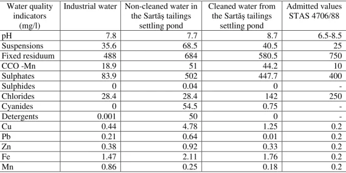
The industrial water for the ore processing plant was supplied from the Arie River, while the used waters and the industrial waste were evacuated through pumping into the Sartă tailings settling pond. The cleaning of these waters was done into a water treatment station placed downstream the tailings settling pond, station which did not function at the planned parameters. The qualitative indicators of the industrial water, of the non-cleaned used waters and of the cleared ones are presented in Table 7. Exceeding values were registered for CCO-Mn, metallic ions (Cu, Pb, Zn, Fe, Mn) and cyanides.
Table 7.Technologic water quality in the Baia de Arie ore processing plant.
Water quality indicators
(mg/l)
Industrial water Non-cleaned water in the Sartă tailings
settling pond
Cleaned water from the Sartă tailings
settling pond
Admitted values STAS 4706/88
pH 7.8 7.7 8.7 6.5-8.5
Suspensions 35.6 68.5 40.5 25
Fixed residuum 488 684 580.5 750
CCO -Mn 18.9 51 44.2 10
Sulphates 83.9 502 447.7 400
Sulphides 0 0.04 0 -
Chlorides 28.4 28.4 142 250
Cyanides 0 54.5 0.75 -
Detergents 0.001 50 0 -
Cu 0.44 4.78 1.25 0.2
Pb 0.21 0.64 0.01 0.2
Zn 0.38 0.92 0.33 0.2
Fe 1.47 2.11 1.76 0.2
Mn 0.86 0.25 0.18 0.2
the ore processing plant in Baia de Arie . This justifies the enormous contents of cyanides in the non-cleaned waters (54.5 mg/l) and very high contents in the non-cleaned waters (0.75 mg/l). As the norms for processing the concentrates were not always respected in a strict manner, we take the liberty to estimate that in the tailings settling ponds situated in this area there are dangerous quantities of cyanides.
If cumulated with the noxes discharged upstream from the Ro ia Montană and Ro ia Poieni objectives, the waters of the Arie have become some of the most polluted waters in the country, a fact megascopically visible. In fact, the first signs of life in the waters of the Arie appear only after the water aeration threshold at Moldovene ti.
The high-impact pollutions produced in 1972 and in 1978 are worth mentioning, when, as result of the mine fires extinction, waters with a pH under 1.5 and with enormous loading of metallic ions were discharged into the Arie . This had as result a catastrophic pollution of the Mure River up to its flow into the Tisa River, a fact which represented also a dispute at diplomatic level between Romania and Hungary, followed by important financial compensation for damages paid by the Romanian state.
2.2. Degradation of hydrographic basins and water pollution in the Ampoi basin and in other small rivers on the south-eastern and southern border
The mining units that have affected aquatic environment in this area are Zlatna, Certej - Săcărâmb, TroiŃa - Bolcana and VorŃa.
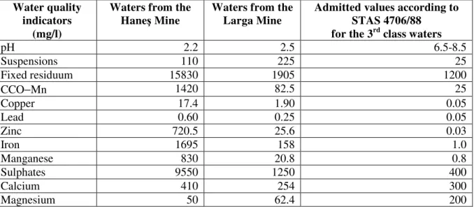
In the Zlatna mining perimeter, the hydrographic network has been disorganized due to the construction of the tailings settling ponds on the course of the Valea Sfârci and on the Valea Mică and through the blocking of the Hane and the Larga rills with mine waste dumps. The waters in the Larga Mine flow into the Ampoi River with a discharge of 100 m3/day, while the ones in the Hane Mine flow into the Alma Valley (tributary of the Geoagiu River) with a discharge of 600 m3/day. The mine water quality is also affected by the presence of great quantities of metallic ions (Cu, Pb, Zn, Fe, Mn) and by a very acid pH (see Table 8).
Table 8.Mine water quality (Hane +Larga).
Water quality indicators
(mg/l)
Waters from the Hane Mine
Waters from the Larga Mine
Admitted values according to STAS 4706/88
for the 3rd class waters
pH 2.2 2.5 6.5-8.5
Suspensions 110 225 25
Fixed residuum 15830 1905 1200
CCO−Mn 1420 82.5 25
Copper 17.4 1.90 0.05
Lead 0.60 0.25 0.05
Zinc 720.5 25.6 0.03
Iron 1695 158 1.0
Manganese 830 20.8 0.8
Sulphates 9550 1250 400
Calcium 410 254 300
Magnesium 50 62.4 200
High exceeding values were also registered for fixed residuum, CCO-Mn, suspensions, sulphates, manganese and metallic ions (Cu, Pb, Zn, Fe). The discharges of the waters from the Hane Mine and the concentration of polluting elements have increased once the collapsing cone of Stokul Mete an was created (Hane Mine).
alarming. The phreatic waters that receive water from the fluvial network have been polluted so that the water in the wells situated in Alma u de Sus has become undrinkable, while the river waters cannot be used for animal watering or for domestic use.
Figure 4.The Alma Rill – acid mine water.
The waters flowing from the tailings settling ponds of Zlatna register exceeding values for copper, lead, zinc, iron, manganese and cyanides.
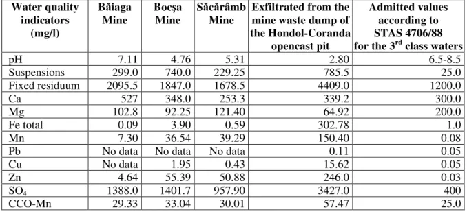
In the Certej – Săcărâmb mining perimeter, waters are collected into the hydrographic basin of the Certej River, a right-bank tributary of the Mure River. Thus, the mine waters run freely into the emissary, the ones from the Boc a Mine into the Boc a Rill, the ones from the Hondol-Băiaga Mine into the Certej River, and the ones from the Săcărâmb Mine into the Nojag Rill. In the perimeter of the Hondol-Coranda opencast pit, the hydrographic network has been totally disorganized and the waters from the opencast pit flow into the Băiaga Rill. The mine and the opencast pit waters are characterized by high contents of solid suspensions, fixed residuum, metallic ions (Cu, Zn, Fe, Mn) and sulphate ions (SO4-2). In Table 9, the lack of lead in the mine waters and the very acid pH of the waters flowing from the mine waste dump of the Hondol-Coranda opencast pit can be noticed.
Table 9.The quality of mine and of opencast pit waters (Certej - Săcărâmb).
Water quality indicators
(mg/l)
Băiaga Mine
Boc a Mine
Săcărâmb Mine
Exfiltrated from the mine waste dump of the Hondol-Coranda
opencast pit
Admitted values according to STAS 4706/88 for the 3rd class waters
pH 7.11 4.76 5.31 2.80 6.5-8.5
Suspensions 299.0 740.0 229.25 785.5 25.0
Fixed residuum 2095.5 1847.0 1678.5 4409.0 1200.0
Ca 527 348.0 253.3 339.2 300.0
Mg 102.8 92.25 121.40 64.92 200.0
Fe total 0.09 3.90 0.59 302.78 1.0
Mn 7.30 36.54 39.29 150.40 0.08
Pb No data No data No data 0.11 0.05
Cu No data 1.95 0.43 15.62 0.05
Zn 4.64 55.39 50.88 246.0 0.03
SO4 1388.0 1401.7 957.90 3427.0 400
The industrial water supply for the mining objective was done through pumping water from the Mure River, at a discharge of 7000 m3/day, while the tailings were deposited in the Mire Valley and in the Valea Mealu.
The waters flowing from the Valea Mealu tailings settling pond present quality indicators characterized by exceeding values for suspensions, fixed residuum, metallic ions (Pb, Zn, Mn), SO4, chlorine and cyanides (Table 10).
Table 10.The quality of the waters flowing from the Valea Mealu tailings settling pond (Certej - Săcărâmb).
Maximum admitted values Water quality
indicators (mg/l)
Water flowing from the Valea Mealu tailings
settling pond
According to Dir. OGA nr.2/11.01.1994
According to STAS 4706/88 for the 3rd class waters
pH 7.30 6.5-8.5
Suspensions 132.0 25 -
Fixed residuum 2376.0 - -
CCO-Mn 20.2 - 1000
Ca 339.2 - 15
Mg 43.7 - 200
Fe total 2.0 - 100
Cu 0.09 0.095 1.0
Pb 0.01 0.084 -
Zn 0.73 0.04 -
Mn 5.60 - -
Cd No data 0.045 -
SO4 1417.2 913 -
Cl 170.4 - -
Cyanides 0.040 0.01 -
The water in the Valea Mealu tailings settling pond flows into the Certej Rill which also receives downstream, on the right, the waters from the Valea Mire ului tailings settling pond and which presents a neuter pH and a relatively high concentration of calcium ions (668 mg/l) due to the presence of lime in deposit. High concentrations of sulphate (1338.2 mg/l) are also reported, as result of sulphides decomposition. The waters of the Certej Rill have polluted through infiltrations also the phreatic levels in the floodplain, as it was established in the quality of well waters in the village of Bârsău, which, in certain periods of the year become undrinkable. This is explained by the fact that during rainy periods, in the Valea Mealu tailings settling pond, which has no guard channel, waters accumulate behind the dam forming a real lake. The waters in the pond frequently exceed the upper level of the dam and flow over under the form of some mud gullies, transporting enormous quantities of industrial sand which they discharge in the damage pond from where is received by the waters of the Valea Mealu and, afterwards, by those of the Certej and of the Mure . In these periods, the Certej River becomes a mudflow, as 1997, when more than 50 ha of agricultural land were silted, the thickness of the depositions exceeding 10-15 cm.
catastrophic characteristics were given by the surprise element and by the rapidity the mud flowed from the settling pond. The breaking of the dam occurred with a real explosion (blast) and after a few minutes the mud flowed over the inhabitants’ houses, over the blocks of the unit’s personnel, demolishing it. The fluid extended on the Certej Valley up to the Mure River, deteriorating through deposition large agricultural areas situated in the floodplain of the Certej Valley and of the Mure River. No data were provided regarding the damages produced in the aquatic environment, the accident being of secret nature. However, we may assert that, in the settling pond, there were high quantities of cyanides and other flotation reagents.
The waters from the TroiŃa Mine have a discharge of 420 m3/day and run freely at the level of the Grimm gallery into the Bolcana Rill, a left-bank tributary of the Caian Rill that flows into the Mure River, downstream the locality of oimu . The quality of these waters is characterized by exceeding values for pH, fixed residuum, sulphates and metallic ions (Cu, Pb, Zn, Fe), as well as by a very acid pH (Table 11).
Table 11.The quality of the waters from the TroiŃa Mine and of those in the Căian Rill.
Water quality indicators
(mg/l)
The Caian Rill upstream
Water from the TroiŃa Mine
The Caian Rill downstream
Admitted values according to STAS 4706/88
for the 3rd class waters
pH 8.09 2.78 8.02 6.5
Fixed residuum 400 3352 432 1000
CCO−Mn 9.47 8.95 7.35 15
Sulphates 83.9 2070.6 106.9 400
Pb 0.16 26.5 0.20 0.1
Cu 0.12 1.06 0.14 0.1
Zn 0.14 94.5 0.18 0.1
Fe 1.04 83.3 1.24 1
Mine waters have only little influence upon the water quality of the Caian Rill due to their low discharge value, as well as to the share of waters containing carbonates, which flow from the Crăciune ti lime opencast pit and regulate the pH. Exceeding values are registered upstream, as result of the waters received from the BăiŃa−Crăciune ti Mine (in preservation) and from the Bolcana Mine.
The waters evacuated from the VorŃa Mine through the two flank galleries (Valea Heiu and Pârâul Băii) are discharged into the VorŃa Valley, a rightârâul Băii gallery is of 10 m3/day, while the discharge of those proceeding from-bank tributary of the Mure River, in the Ilia area. The discharge of the waters proceeding from the P the Valea Heiu is of 15 m3/day. The quality of these waters is also characterized by the presence of metallic ions (Cu, Zn, Pb, Fe), but their influence upon the waters of the VorŃa Valley is insignificant due to the low discharges of the mine waters (Table 12).
Table 12.The quality of the waters from the VorŃa Mine and of those in the VorŃa Valley.
Water quality indicators
(mg/)
The Pârâul Băii gallery
The Valea Heiu gallery
The VorŃa Valley (downstream)
Admitted values according to STAS 4706/88
for the 2nd class waters
pH 8.45 7.6 8.65 6.5-8.5
Suspensions 140 68 40,0 -
Fixed residuum 784 892 320 1000
CCO−Mn 15 30 5.24 15
Sulphates 498.7 525 49.4 400
Cu 0.13 0.13 0.1 0.1
Zn 0.18 0.18 0.12 0.1
Pb 0.16 0.14 0.11 0.1
The Mure River receives mine waters also from the geological research works conducted for rare metals and radioactive elements in the hydrographic basin of the Milova Rill. No information about the quality of these waters is available, as researches in the area were kept secret for a long time, and, after 1990, the geological research activities ceased. However, these waters are assessed to have been radioactively polluted as uranium minerals are known to be very water-soluble.
2.3. Degradation of the hydrographic basins and water pollution in the Cri ul Alb basin
The Cri ul Alb River collects the industrial waters from the former underground exploitations of Barza and from the Valea Arsului opencast pit. The Cri ul Alb also receives the waters proceeding from the geological research works of Ciungani – Căzăne ti.
The Valea Arsului, in whose retention basin the Valea Morii opencast pit is also situated, has been hydrographically disorganized in the upper basin as result of excavating into its right flank and of obturating the Valea Cire ata basin, right-bank tributary of the Valea Arsului, through filling with the mine waste resulted from ore uncovering.
Both from the opencast pit and from the mine waste dump, during rain showers, great quantities of alluvia flow into the Cri ul Alb.
The waters from the Breaza Mine have a discharge of 7170 m3/day and are discharged into the Barza Rill, left-bank tributary of the Cri ul Alb. Their quality is rendered in Table 13.
Table 13.The quality of the waters from the Barza Mine.
Water quality indicators (mg/l)
Mine waters Admitted values according to
STAS 4706/88
pH 2.82 6.5-8.5
Suspensions 440 25
Fixed residuum 4280 750
Cu 5.8 0.2
Pb 0.335 0.2
Zn 17.89 0.2
Fe 27.0 0.2
So4 2140 -
The very acid character can be noticed, as well as the exceeding values for suspensions and fixed residuum, metallic ions (Cu, Zn, Fe) and SO4.
Table 14.The quality of the waters flowing from the RibiŃa-Curteni tailings settling pond.
Water quality indicators (mg/l)
Cleared waters from the RibiŃ
a-Curteni tailings settling pond
Admitted values according to O.G.A. Agreement no. 354/78
pH 7.28 6.5-8.5
Suspensions 88 50
Fixed residuum 1718 1200
Cyanides 0.02 -
SO4 310 -
Cl 12 -
Phenols No data 0.02
Fe 0.25 0.10
Cu 0.011 0.30
Pb 0.005 0.05
Zn 0.133 0.5
values, two times higher than the admitted concentrations for iron and zinc, as well as for suspensions and fixed residuum. Exceeding values in rapport with the OGA Agreement were registered for cyanides as well, but they range among the norms admitted by STAS 4706/88 (Table 14).
No data about the waters proceeding from the geological research works of Ciungani-Căzăne ti is available.
3. EFFECTS OF THE MINING IMPACT UPON THE AQUATIC ENVIRONMENT IN THE STUDIED AREA.
The degradation of the hydrographic basins implied the exclusion from the agricultural (arable, pastures and hayfields) and forestry circuit of some large areas (Ro ia Montană, Ro ia Poieni, Hondol-Coranda, Valea Arsului, etc), as well as the silting of the riverbed, of the main collectors, inclusively (the Mure and the Cri ul Alb).
As regards water pollution, major values exceeding the admitted norms have been registered for pH, metallic ions and cyanides, all with direct and indirect effects upon biota.
Thus, very acid pH was recorded for the waters from the Ro ia Montană(2.6), Hane (2.2), Larga (2.5), TroiŃa (2.78), and Barza (2.82) mines and for the waters flowing from the mine waste and the poor ore dumps from Ro ia Poieni opencast pit (2.25 and 2.3). The acid pH determines the acid drainage called "galiŃă" which consists in the production of sulphuric acid from the mineral sulphides that encounter air and water. The phenomenon is perceived through the brown-reddish water, determined by the presence of Fe3+ in suspension, and by the oozy, brown-reddish to deep red depositions, consisting of iron oxy-hydroxides and of other precipitation minerals. If the phenomenon is produced within a mine, it is called “mine acid drainage” and when it takes place within the mine waste dumps, as in the case of Ro ia Poieni, it is called “rock acid drainage” (Popescu et al., 2007). The acid pH has direct negative effects upon the aquatic flora and fauna, as well as secondary effects such as the decrease of the oxygen contents, the increase of the carbon dioxide tension, all contributing to an increase of the toxicity of these waters which have become real dead waters (Duma, S., 2008).
High exceeding values of the contents ofmetallic ions were recorded for the waters from the Cetate Mine in Ro ia Montană (1.50 Cu, 1.0 Pb, 43.6 Zn, 261.9 Mn, in mg/l), Hane Mine (720.5 Zn, 1695 Fe, 830 Mn, 0.60 Pb, 17.4 Cu, in mg/l), Larga Mine (1.90 Cu, 25.6 Zn, 158 Fe, 20.8 Mn, in mg/l), Săcărâmb Mine (50.88 Zn), Barza Mine (17.89 Zn in mg/L) and TroiŃa Mine (26.5 Pb, 1.06 Cu, 94.5 Zn, 83.3 Fe, in mg/l). In Ro ia Poieni, high contents of copper were registered in the waters flowing from the mine waste dumps (473.3; 333; and 44.4 in mg/l). It was observed that, usually, the higher the contents of metallic ions in waters, the more acid the waters, so that their effects are synergetic. In the case of people, the consumption of lead-laden water produces memory disorders, hands paralysis and cancer, while in the case of children it affects the metabolic and the immune system and leads to a decrease in intelligence. Zinc produces epigastric and cardiovascular disorders, diarrhea, tremble, paresis (Taitner, 1988). In the case of animals, it produces digestive disorders (diarrhea), salivations, convulsions, paralyses of muscles and of larynx, tumefactions of articulations (Coman, N., 1991).
High contents of cyanides were recorded in the waters of the Săli te Valley tailings settling ponds - Ro ia Montană (0.32 mg/l), in the Sartă tailings settling pond - Baia de Arie (0.75 mg/l) and in the Valea Mealu tailings settling pond of Certej- Săcărâmb (0.040 mg/l). Fish are the most affected by the presence of cyanides in waters. For them, the contents of 0.03 mg/l HCN in waters are fatal (Witt et al., 2004). The consumption of cyanide-laden water produces headaches, vomiting, breathe disorders, tachycardia, coma, and, in the case of concentrations exceeding 300 mg/l, death (Taitner, I., 1998).
Certainly, there are also some other substances such as sulphates, chlorides, fixed residuum and suspensions that have negative effects upon the biota in the aquatic environment and upon consumers, but their effects are more reduced.
water oxygenation their natural clearing is accomplished. The construction of some guard channels on the perimeter of the tailings settling ponds situated in valleys is also recommended, to receive the slope runoff, avoiding this way the transportation of industrial detritus and of noxes into the fluvial network. The construction of some concrete, contour channels is proposed for the tailings settling ponds situated in floodplains, with role in decanting the waters flowing from the taluses. The deposition of fertile soil and the fixation with forestry vegetation is recommended for the tailings settling ponds with ceased activity, a fact that will reduce substantially the discharge of nox-laden waters into the fluvial network.
The rehabilitation of the aquatic environment in the Southern Apuseni Mountains has to be done on the basis of some projects (programmes) that aim at the ecological reconstruction of all the environmental factors in the area.
REFERENCES
COMAN, N., (1991), Introducere în tiinŃa vieŃii [Introduction to Life Science], Edit. Universitatea Ecologică, Bucure ti.
DUMA, S., (1998), Studiul geoecologic al exploatărilor miniere din zona sudică a MunŃilor Apuseni, MunŃii Poiana Ruscă i MunŃii Sebe ului [Geoecologic Study of Mining Exploitations in the Southern Area of the Apuseni Mountains, the Poiana Ruscă Mountains and the Sebe Mountains], Edit. Dacia, Cluj-Napoca.
DUMA, S., (2006), Resursele i mediul [Resources and Environment], Edit. Universitară, Bucure ti. DUMA, S., (2008), Impact of Mining Activity upon Environment in Ro ia Montană, in Romanian
Review of Regional Studies. Journal of the Center for Regional Geography, Edit. Presa Unversitară Clujană.
EGAN, T., (2000), The Death of a River Looms over Choise for Interior Post, New York Times, 7 January 2001, Cyanide-Spill Suit is Settled in Colorado, New York Times, 24 December 2000.
POPESCU GHE., TĂMA BĂDESCU S., BOGATU L., TĂMA BĂDESCU G., NEAC U A., (2007), Geologia economică a aurului [Economic Geology of Gold], Edit. Aeternitas, Alba Iulia.
POSTEL, S., RICHTER, B., (2003), Rivers for Life: Managing Water for People and Nature, Washington DC: Island Press.
TAINTER J., (1988), The Collapse of Complex Societies, Cambridge University Press.
WITT, K.J., SCHÖNRADT, M., SAARELA, J., FRILANDER, R., CSICSAK, J., CSÖVARI, M., VÁRHEGYI, A., GEORGESCU, D.P., RĂDULESCU, C.A., ZLĂGNEAN, M., BÕHM, J., DEBRECZENI, Á., GOMBKÖTÕ, I., XENIDIS, A., KOFFA, E., KOURTIS, A., ENGELS, J., (2004), Sustainable Improvement in Safety of Tailings Facilities; Report: Tailings Management Facilities - Risks and Reliability European Research and Technological Development Project, Contract Number: EVG1-CT-2002-00066.
* * * (1978), Acord OGA 354/78. * * * (1988), STAS 4706/88.
* * * (1991), AutorizaŃia nr.10 /1991 [Authorization No. 10/1991].
* * * (1992), Atlasul cadastral al râurilor României [Cadastral Atlas of the Rivers of Romania], INMH Bucure ti.
* * * (1994), Dir. OGA nr.2 - 01 /1994.
* * * (1997), Ordinul MAPM nr.756/03.11.1997 [Disposition of the Ministry of Water, Wood and Environment No. 756/03.11.1997].