IN THE SOUTH AND CENTRE OF PORTUGAL: SOME NOTES
ABOUT VIOLENCE AND WALLS IN THE 3rd MILLENIUM BCE
1Muros, puertas y torres. Asentamientos fortificados en el centro y sur de Portugal: Algunas notas sobre la violencia y las murallas en el tercer milenio A.N.E. VICTOR S. GONÇALVES *, ANA CATARINA SOUSA * and CATARINA COSTEIRA *
“Every wall is a door” Ralph Waldo Emerson, 1808-1882
ABSTRACT In relation to the question of violence in the third millennium BCE, a synthesis is presented
of fortified sites situated in the Centre and South of Portugal. The analysis is divided into three large territorial units: 1. Upper Eastern Algarve, with special emphasis on the Cerro do Castelo de Santa Justa; 2. Alentejo, in particular the middle Alentejo, where some re-cently excavated settlements and farms are to be found (São Pedro and Porto das Carretas); 3. Estremadura, the region where there is the largest concentration of fortified settlements (currently numbering 18), with over a century of archaeological research.
Four main aspects were considered in testing for the possible existence of signs of violen-ce: 1. Models of implantation; 2. Chronologies and discontinuities in the occupation of the sites; 3. Defensive architectures, especially the general ground plans, towers and gates, and internal and external reinforcements. 4. Reconstructions and remodellings.
By comparing these indicators with other archaeological data, the fortifications are consi-dered as a reaction to the violence that existed between communities, testifying to effective territorial appropriation and denoting migratory movements of the first copper archaeome-tallurgists originating from Andalusia.
Key words: Third Millennium BCE, Chalcolithic, Violence, Fortifications, Archaeometallurgy,
Portugal.
* Centro de Arqueologia da Universidade de Lisboa (UNIARQ), Grupo de trabalho sobre as Antigas Sociedades Camponesas, vsg@campus.ul.pt, sousa@campus.ul.pt, catarinacosteira@gmail.com
Fecha de recepción: 20-02-2014. Fecha de aceptación: 27-06-2014. 1. Translated from portuguese by John Elliot.
RESUMEN En relación con la violencia en el tercer milenio A.N.E. se presenta una lectura de síntesis
de los sitios fortificados situados en el centro y el sur de Portugal. El análisis se divide en tres grandes unidades territoriales: 1. Alto Algarve Oriental, con especial énfasis en el Cerro do Castelo de Santa Justa; 2. Alentejo medio, donde se sitúan sitios recientemente excavados (São Pedro y Porto das Carretas); 3. Estremadura, donde se situa el mayor número de aldeas e fincas fortificadas (actualmente 18), con antiguos antecedentes de investigación. Se consideraron cuatro vectores principales para probar si hay signos de violencia: 1, Modelos de asentamiento; 2, Cronología y discontinuidades de ocupación; 3, Arquitecturas defensivas, con especial referencia a las plantas de las fortificaciones, torres y puertas, refuerzos internos y externos; 4, Las reconstrucciones y remodelaciones.
Cruzando estos indicadores con otros datos del registro arqueológico, consideramos las forti-ficaciones como una reacción a la violencia entre comunidades, siendo testigos que traducen eficazmente la propiedad territorial y los movimientos de los primeros arqueometalurgistas del cobre venidos de Andalucía.
Palabras clave: Tercer milenio A.N.E., Calcolítico, Violencia, Fortificaciones,
Arqueometa-lurgia, Portugal.
REGARDING SOME OF THE MAIN QUESTIONS The territory
The vast region of southern Portugal has been constantly referred to as the Centre and South of Portugal, an area that includes the hydrographical basins of the Rivers Tagus, Sado and Guadiana (Ribeiro et al., 1987). This territorial unit comprises regional realities that are defined not only by geographical criteria, but also by matters of a cultural nature and even by realities arising from the pace of archaeological research itself. We can therefore identify areas such as Estremadura, the Alentejo and the Algarve, which in fact correspond to the large administrative units that were in use until the 1970s. Despite certain cultural and natural specificities, there is a clear interaction between the regions of this vast territory, which has been detected since the most ancient times.
The boundary of the Algarve is clearly marked by the hills of the Serra Algarvia (Monchique e Caldeirão), a natural barrier that separates the south of the Alentejo from the Algarve (Gonçalves, 1989:92). This territory is naturally subject to influences from the Alentejo in the hills and from Andalusia along the coast (Gonçalves 1995:212).
The region to the South of the Tagus corresponds to a fully Mediterranean territory. In geological terms, the most important area is the middle Alentejo, with metamorphic and eruptive rocks from the ancient massif and the tertiary basins of the Tagus and Sado. The peneplain is the dominant feature, corresponding to a landscape “...of plains and middle plateaus, with extensive depressed river basins and terrains gently interspersed with rare mountain areas” (Ribeiro, 1954:41), with roughly 63% of its area being situated below 200 metres in altitude.
Estremadura has the appearance of a narrow, elongated strip of land that comprises very different physical and human landscapes. Bordered to the east by the Tagus basin, to the west by the Atlantic Ocean, and incorporating the peninsulas of Lisbon and Setúbal, in the past the coastline would have been considerably more uneven than it is nowadays, as has already been shown by the pioneering studies of Suzanne Daveau
(Daveau, 1980). The coastal strip is jagged in shape, with abundant watercourses, linking the “inland” and “coastal” regions (Gonçalves, 1995).
The configuration of this territory was formed 200 million years ago, with successive deposits, movements of the coastline and numerous volcanic episodes that determined the diversity of its soils and shaped the reliefs of the Estremadura landscape (Mattoso
et al., 1997:10). The geological substratum of Estremadura corresponds to a mosaic,
being fundamentally composed of Cretaceous and Jurassic formations, with large areas of marls and calcareous soils, interspersed with basaltic formations, alternating rocks with very distinct degrees of hardness, permeability and plasticity.
Preliminary questions
In view of the available information, we consider that, for the third millennium in the Centre and South of Portugal, the analysis of violence should be centred not only on the palaeopathologies of skeletons, but above all on the question of the region’s fortifications and the actual strategy of its settlement. Other important indicators, such as the anthropological ones (Silva et al., 2012; Waterman et al., 2014), also correspond to an approach that is under construction, so that it is difficult, at this point, to propose any general readings of these. Fortified sites are, in turn, a subject that has been researched in Portugal for more than a hundred years, with 32 sites already excavated or under excavation, and an extensive published bibliography.
There may be several reasons for building a wall:
1. Political reasons (defining and asserting autonomy, symbolising local power); 2. Economic reasons (protecting flocks, surplus food products, copper artefacts,
and containing or limiting the area of a possible social disintegration);
3. Territorial reasons (closing off areas of special significance) or defending sacred areas (see Monks, 1997:8).
In any case, it is presupposed that walls form a defence and that there is consequently an expectation or a reaction to the occurrence of signs of intergroup violence, on a micro or macro regional scale.
We can also imagine that walls had multiple (and sometimes cumulative) meanings, in the course of the period under study. While, at first, the building of a fortification is an action that presupposes a group preoccupation with defence, in other contexts walls may lose their military significance and take on new functions, such as the dissuasive demonstration of power or the social and economic circumscription of the community. Thus four main aspects were taken into consideration for testing the eventual existence of signs of violence in the design and location of the fortified settlements:
1. Models of implantation;
2. Chronologies and discontinuities in occupation; 3. Defensive architectures;
Models of implantation
The different models of implantation are analysed through a case-by-case study of each of the settlements per se, and, from a general perspective, by interpreting the location of the fortified sites in their respective territory.
As far as the individual approach to these sites is concerned, we can consider the following indicators of natural defensibility: 1) visibility; 2) natural obstacles; 3) natural protection; 4) control of the routes of communication (Sousa, 2010:527).
The interpretation of the territorial implantation of these sites takes into account all of the contemporary settlement of the region, together with the specificities of the various terrains described above. Naturally, this type of spatial approach to the question is always a reflection of the history of the research undertaken so far, the visibility of the land in question and the archaeological contexts. Even so, cases were selected that had been studied directly by the authors, and in some depth: the valley of the River Sizandro (Kunst & Trindade, 1991) and the basin of the Ribeira de Cheleiros (Sousa, 2010), for the area of Estremadura; the territory of Reguengos de Monsaraz (Gonçalves, 1999, Gonçalves & Sousa, 2000; Leisner & Leisner, 1951; Valera, 2012) and the Serra de Ossa (Calado, 1994; 2001) for the Alentejo and the Upper Eastern Algarve (Gonçalves, 1989).
Chronologies and (dis)continuities in occupation
Reading and interpreting the foundational chronologies of the fortified settlements and their correlation with the panorama of the Late Neolithic period may be a very important indicator for interpreting the endogenous and exogenous origins of the builders of walls and their correlation with emerging signs of violence.
This approach also presents one of the greatest challenges, considering the stratigraphic complexity of these sites (see the case of São Pedro, in Redondo, or Zambujal) and of the limited number of absolute datings (which were only sufficient in number for Zambujal and Liceia).
Defensive architectures
The use of the term architecture to describe these constructions results from the assumption that there was a project that preceded their implantation and that certain criteria were applied regarding the organisation of space. The main defensive characteristics of these fortifications were taken into account: the general ground plan, gates and towers. Our analysis was repeatedly restricted by the partial nature of research, sometimes resulting from the fact that only small areas had been excavated and that the work had lasted only a short time, even in key sites, which limited the scope of possible readings.
The question of the full ground plan of sites is naturally a very complex one, in view of the size of the settlements and the difficulty in applying geophysical survey methods in every case. Thus, unlike ditched enclosures, which are difficult to detect at the surface (although overall pictures of the sites can be obtained through aerial photography or geophysical surveys), fortified settlements can be identified at the surface, although it is difficult to survey these using geophysical methods.
The organisation of the enclosures in multiple defensive lines is also a feature that is common to some of these sites, naturally indicating a greater defensive concern or perhaps a long diachrony of fortifications.
Access to enclosures and fortifications was controlled through the use of gates, whose construction and design also conveyed a certain strategic and symbolic importance. From a defensive point of view, gates were one of the most vulnerable points of the whole system, so that it was necessary to find strategies that would ensure their security, namely by building support (or protective) structures or by designing them in such a way as to prevent attackers from advancing directly from the outside to the inside (Gonçalves, 1989; Keeley et al., 2007).
In the case of defended gates, L. Keeley, M. Fontana and R. Quick systematised the various architectural solutions that were adopted from a transregional perspective and over a fairly long diachrony (Keeley et al., 2007), pointing to the existence of three main architectural solutions, some of which were cumulative: 1) controlled gates; 2) screened gates; and 3) flanked gates.
The low number of fortified enclosures that have been fully excavated makes the number of gates detected unreliable. But it is clear that different constructive solutions existed.
The prominent features have a clear defensive value, with towers being especially important. The great number of towers that existed at these fortified sites is one of the features that marks their distinctive style across the whole Mediterranean region.
In terms of military architecture, a bastion is a barrier that can be used for the positioning of several individuals and their defensive equipment at a higher point than the top of the wall, with the purpose of throwing projectiles, or fire, in order to stop possible attackers (Keeley et al., 2007:67). This type of structure is usually a high construction that enhances its defensive capacity (Keeley et al., 2007:68). The direct and unquestionable application of this concept to fortifications of the third millennium cannot be made literally, since archaeological contexts show that, to a certain extent, the military concept of pure defence does not strictly apply here. Instead, we use here the word “tower”, which is considered to be broader in its application, rather than “bastion”, which is the expression preferred by some authors, although it is more restrictive in nature.
The effort required to build towers would have been much greater, and they could raise the cost of building a defensive system by somewhere between 30 and 100% (Keeley, 2007:70). Looking at this situation strictly from the viewpoint of military architecture, we may consider that, in view of the greater cost, only the short range of the projectiles used in the third millennium could justify the multiple use of these structures. It should be pointed out that, in the case of the towers built on the outside of temples and palaces in Egypt and Mesopotamia, the spaces between them were also
very short (roughly five metres in distance), since the area considered to be within range of defence would be quite small. This was immediately noticed by Lieutenant Colonel Salgueiro Maia, when he visited Vila Nova de São Pedro, remarking that the archers who defended the towers ran the risk of killing one another...
On the other hand, we must consider that the placement of towers might have had the cumulative function of buttressing the different sections of the wall, preventing them from slipping down steep slopes.
The question of the “hollow tower-solid tower dichotomy” is particularly important for those sites that present both solutions. The domestic use that was made of hollow towers has in fact led some people to argue that the fortifications correspond to models displaying the evolution of Chalcolithic villages: the towers are associated with huts that are joined together by boundary walls (Ramos, 2007). The lack of any standardised distances that would permit an effective control and the “excessive” number of towers that is noted both at Santa Justa and other fortified sites, makes the question of the (co-)existence of various functions here an open one: a hollow tower would quite probably be used for storage, as well as for domestic and defensive purposes, whereas solid towers would possibly be used for defensive purposes and as small towers that could serve as buttresses.
Reconstructions and remodellings
The great building programmes were implemented at the beginning of the life of these settlements, mainly dating from the end of the first quarter of the third millennium BCE.
If we take Liceia and Zambujal as indicators, we may consider that the defensive system was built, used and remodelled over a period of 300-400 years. During these centuries, two situations were to be noted:
1. Maintenance works, arising from the disintegration of dry stone structures; 2. Changes in the strategy for the site’s defence or its eventual status as a monument. In the case of the disintegration of such structures, M. Kunst has highlighted the possibility of maintenance works that were related with earthquakes: “We cannot think that each destruction results from human action, such as war or episodes of conflict, and the possibility of the occurrence of earthquakes must also be considered, since the centre of Portugal is still affected by earthquakes today, with the greatest example being the 1755 earthquake that destroyed the whole of the Baixa (downtown) area of Lisbon, as perpetuated in Voltaire’s “Poème sur le désastre de Lisbonne” (Kunst, 2010:135). This line of interpretation could be developed even further, given the history of earthquakes on Portuguese territory. João Araújo Gomes has undertaken research under the scope of archaeoseismology (Gomes et al., 2008), presenting as a case study the collapses of structures at various Portuguese archaeological sites, namely the tholos Alcalar 7, where there are signs of an inclination of the corridor and pop-up effects in the pavement (Gomes et al., 2008:90). If one looks at the map of active faults in the
Pleistocene and Quaternary, it can be seen that, in the case of Estremadura, the faults were concentrated in the Lisbon area and the Tagus estuary (Cabral, 1995), and there do not seem to have been any occurrences of faults in the northernmost part of the Lisbon Peninsula, where sites such as Zambujal or Penedo do Lexim are located. Even so, we must consider this hypothesis for a possible geoarchaeological study, paying attention to an interdisciplinary approach: “…both excessive recourse to the hypothesis of seismic destruction for the archaeological sites and excessive caution in putting forward this possibility are signs of a poor effective knowledge and the insufficient value that is given to interdisciplinary knowledge” (Gomes et al., 2008:90).
The natural disintegration resulting from the climate is also considered as a possibility by M. Kunst, even though he disregards its possible importance to some extent: “the atmospheric phenomena of winter may also have given rise to some collapses of lesser importance” (Kunst, 2010:135). The question of natural disintegration will have to be considered in accordance with the constructive specificities of each fortified settlement. A dry stone wall, held together only by clay and packed earth would have had a relatively limited stability, further exacerbated by its greater or lesser height. In a uchronic analogy for the Estremadura region, we can see that, at the fortress along the Lines of Torres Vedras (1809-1811), made expeditiously of earth and dry stone, without any mortars, there were considerable collapses, with the break-up of the actual geological substratum itself. At the modern fortress of Zambujal (Mafra), excavated by one of us (Sousa, 2011), extensive areas of collapse were detected in the access corridor, which resulted from a process of disintegration occurring after only 200 years.
Also needing to be taken into consideration are the constructive differences between walls and towers, resulting from the natural substratum and building techniques. Structural differences between the walls of Penedo do Lexim, built with enormous basalt prisms, and the walls of Zambujal, built with medium-sized sandstone blocks can be noted. On the other hand, it does not seem plausible that all the fortified settlements present a conserved height that can be compared with that of Zambujal (roughly 4 metres in the central area). In most cases, the structures were identified by their foundations, and it has been suggested for some of them that the building materials used were mixed ones, also involving the use of clay. It was possible that the walls that were raised were made of packed earth, with some large deposits of clay debris being found at sites such as São Pedro and Porto das Carretas.
With prehistoric technology, before the advent of artillery, the only way of deliberately demolishing towers and walls was to dig under the foundations, which naturally was not feasible in this actual case. Were the Chalcolithic fortifications therefore impregnable?
As far as the alteration of the defensive system is concerned, we encountered a variety of situations: additions, reinforcements of the walls and towers and reconfigurations of the layouts.
But what does this process mean?
M. Kunst puts forward a hypothesis for the repairs that were carried out at Zambujal: “...at that time, when the face of a wall was damaged, the inhabitants of the settlement did not replace the stones, but instead they built a new face for the wall on the outside. In this way, with time, the walls became thicker. Normally between this new face and
the older one there was a space filled by smaller irregular-shaped stones” (Kunst, 2003:171). This situation is paralleled at other sites, such as Liceia or Santa Justa.
These repairs or reinforcements point to the continued concern with ensuring that the settlement could be defended and probably also to some social instability existing outside the community.
There were also some alterations made to the ground plan in the walled area, configuring different phases. Usually, the final ground plan that was obtained corresponded to a succession of different building periods, so that it is very difficult to break down this image into the different phases of construction and use. The hypotheses put forward for the cases of Zambujal, Porto das Carretas and São Pedro point to various building phases with significant changes at the level of architecture, and with a general shrinking of the walled area. Considering the average life of the fortifications (roughly 300-400 years), a functional explanation may be put forward based on the idea of maintenance or the need to alter the defensive system in the event of possible new confrontations.
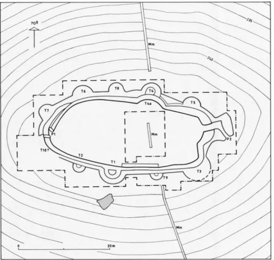
THE UPPER EASTERN ALGARVE
In the Upper Eastern Algarve (Alto Algarve Oriental), three hill settlements were identified in the late 1970s, in this order: the first was Cerro do Castelo de Corte João Marques, which was excavated by one of us (VSG) between 1978 and 1979, not revealing any traces of fortifications in the extensive excavation that was carried out, which, of course, does not mean that they did not exist. However, the difficult access to the top of the hill or the existence of palisades may have replaced defensive systems that took longer to build. It should, however, be said that the abundance of greywacke made it easy, within such a short distance, to acquire and transport a raw material of great solidity and resistance, ideal for the building of walls.
Cerro do Castelo das Mestras was never excavated, but surreys made it possible to identify two, if not three, lines of concentric walls, at the top of the hill. Being situated on a raquette of the river, which itself follows a meandering path, its conditions of defensibility and visibility would have been excellent.
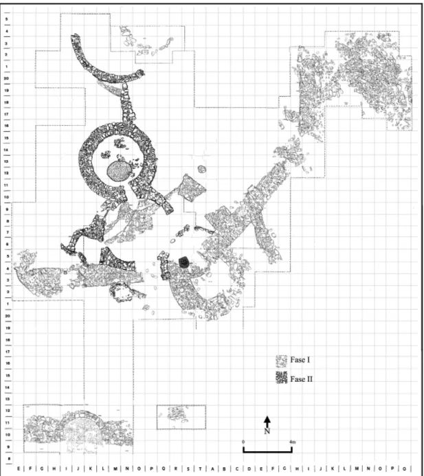
Cerro do Castelo de Santa Justa was identified and almost completely excavated between 1978 and 1985 (VSG). It showed a relatively simple architecture, with all the normal components of these settlements and a stabilised use of resources:
1. Walls;
2. Reinforcements of the walls (internal and external); 3. Gates of different types;
4. Hollow or solid towers (isolated or symmetrically arranged to protect access to the site).
It should also be said that, unlike Zambujal, Liceia or Vila Nova de São Pedro, the walls of Santa Justa, which effectively reveal signs of corrections that were made to the settlement’s layout, show, also unlike the others, that they were enlarged, although not very significantly. Some accidents of life at the site also left their marks on the
structures, or, even when destroyed, have conserved signs of their presence. Let us now look at these components in the order in which they were listed.
Walls
A nuclear greywacke wall formed the basis of a defensive system in the shape of an ellipse, although it is not completely clear whether it was immediately continued or whether it was integrated into the first phase of occupation of the site, which at that time had a large collective hut.
In the square that was excavated, the occupied area is covered by the coordinates E to Q and 8 to 30, corresponding to roughly 1196 m2, but while, at 270 grads, the
hillside is devoid of any archaeological information, at 70 grads, it is quite possible that other structures remain buried there, so high was the density of loose materials found at the surface.
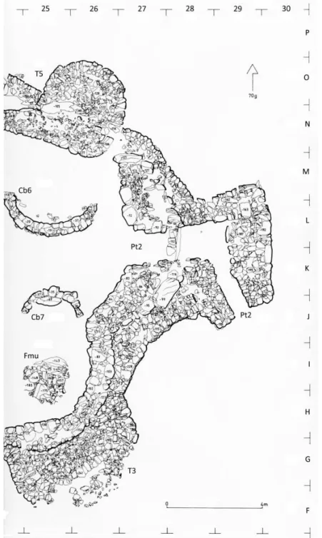
This wall was partially reconstructed, enlarging the initial space of the protected area towards 170 grads. It undulates at the coordinates H, I – 25, running around the multi-purpose oven used for cooking, but also, after its construction, as a furnace for copper metallurgy. Quite probably, the oven lay outside the walls during the settlement’s first phase and was then positioned inside the walls after the enlargement of the area, which implied the building of a new gate and new (T3 and T5), protecting Gate 2 (Pt2) (figs. 1 & 2).
Reinforcements of the walls (internal and external)
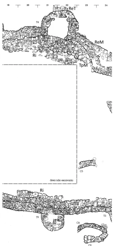
One of the peculiar aspects of Cerro do Castelo de Santa Justa is the fact that the wall’s external reinforcement was built with a very different raw material from the greywacke of the wall itself, namely laminar schist, which accompanied its layout in its entirety. In its entirety? In fact, this is not exactly the case: not only does the reinforcement include towers that were built from scratch, as is the case with T3, T6, T7 and T8, but some of these begin at the outside of the wall, as is the case with T2, T9...
The greywacke wall was also subjected to an external reinforcement, at the coordinate H.20, 21, and it is not impossible that it was also reinforced at the internal part of T4, at the coordinates O, P, 21, 22, where the layout seems to suggest that the old enclosure ended at 170 grads.
Different types of gates
The two gates identified at Santa Justa are completely different, even though they are both relatively simple. The oldest gate, at 370 grads, at the coordinates L, M, 10, 11, is a simple gate defined by two funnel-shaped stones, which were certainly complemented by a wooden endpiece. The settlement’s reconstructed and enlarged
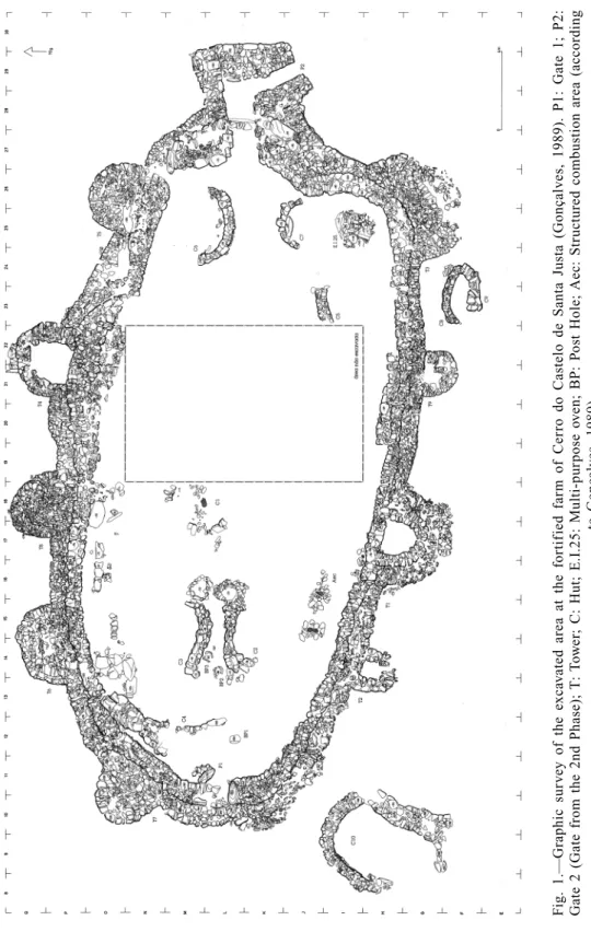
F
ig. 1.—Graphic sur
v
e
y of the e
xca
v
ated area at the for
tif
ied f
ar
m of Cer
ro do Castelo de Santa Justa (Gonçalv
es, 1989). P1: Gate 1; P2:
Gate 2 (Gate from the 2nd Phase);
T
:
T
o
w
er; C: Hut; E.I.25: Multi-pur
pose o
v
en; BP: P
ost Hole;
Aec: Str
uctured combustion area
(according
to Gonçalv
gate, which is located at the coordinates J, K, L, 27, 28, 29, is a bayonet gate, which is integrated into a cohesive defensive system, formed by Tower 3, a large tower in the shape of a half ellipse, and Tower 5, of which only the foundations have been identified, which is integrated into a complex sector of the wall that was built later, so that this really was the settlement’s last active gate... However, if we look closely at the oldest gate (Pt.1), this gate, or the area in which it closed, was protected by Tower 7 and probably by another tower (which would be T.10), of which there appear to be some traces, albeit greatly destroyed, at J.10, 11. This means that both gates had towers protecting them, which is perfectly clear in the case of Pt.2 and quite probable in the case of Pt.1.
Fig. 2.—Simplified reading of the ground plan of Cerro do Castelo de Santa Justa (Gonçalves, 1989). Mm: Modern wall; T: Tower; P: Gate (according to Gonçalves, 1989).
Hollow or solid towers (“isolated” or symmetrically arranged in order to protect access) At Cerro do Castelo de Santa Justa, we have an extraordinary example of a hollow tower, T1, on the inside of which we even found a “horned idol”, an artefact that is normally linked to fire areas, whether these are structured or not (there were seven such areas associated with the multi-purpose oven). It is the oldest tower in the settlement, opening directly onto the inside of the enclosure. T4 is also a hollow tower, and is also incorporated into the layout of the greywacke wall, but there is little artefactual information about its contents. T2 is an example of the micro-towers about which we know very little (there are two such towers at Pedra d’Ouro, in Estremadura, which are integrated into the interior fortification), and T9 is another situation that remains to be clarified, since it is doubtful that it was hollow, like the previous one, or that it had been partially emptied (figs. 3, 4 & 5).
A planned system?
It seems to us that Cerro do Castelo de Santa Justa (a genuine fortified farm) followed a specific construction plan and that the middle phase of its life called for reconstructions and additions, as well as towers and reinforcements that also followed a special programme for their implementation. Its remarkable similarities with Cerro de los Vientos, both at the level of artefacts and architecture, together with other data, reinforces the idea of a route that was followed by the copper archaeometallurgists who came from Andalusia and spread the demand for the metal, becoming involved in trading networks with indigenous populations whose means of production was already in a state of collapse. The quantity and weights of the copper artefacts found here are quite high, when compared with the numbers and values of the Estremadura region itself. At Santa Justa, a furnace was found that had numerous drops of copper spread around its interior, whereas at Corte João Marques this was an open foundry area, and, besides crucibles, some remains of fusion were found in everyday ceramic containers used for this purpose (fig. 6).
THE ALENTEJO
The picture of the human occupation of the Alentejo in the third millennium BCE has changed profoundly since the last few decades of the 20th century, after the first research work was undertaken at Reguengos de Monsaraz (Gonçalves, 1988-89; 1993) and on the Alentejo coast (Silva & Soares, 1976-77), and also in other isolated interventions (Gomes, 1991; Parreira, 1983). The significant increase in the number of archaeological interventions designed to minimise the impacts caused by the development of urban and rural centres and the construction of large infrastructures, such as the Alqueva Dam and Reservoir, has led to an exponential growth in the number of contexts that fit into this chronology. The increase in the amount of available data led to a broadening of horizons, since not only were there more sites, but new realities also appeared, which were large in size and had fairly extensive diachronies.
Fig. 3.—The extremity at 370 grads of Cerro do Castelo de Santa Justa. P1, the oldest gate, consisting simply of two large stones arranged in a funnel shape (when this gate was closed as a result of reinfor-cement work, this area remained protected by Tower 7 and the presumed Tower 10); Hut 4, very badly destroyed, initially raised doubts as to whether or not it represented a section of wall from an earlier phase
Fig. 4.—The extremity at 170 grads of Cerro do Castelo de Santa Justa. P2, the gate from the second phase (Pt2). This is a bayonet gate, protected by Towers 5 and 3. The multi-purpose oven Fmu, which lay outside the walls at the beginning of the settlement’s existence, determined the convex shape of the wall
Fig. 5.—Internal reinforcements of the wall (Ri), the outside of Tower 4, the outside of the wall (Rem) and the original layout of the wall (Tpm) (according to Gonçalves, 1989).
Fig. 6.—Copper artefacts of greater sizes and weight, found in the Upper Eastern Algarve. The first two, above, from Corte João Marques. The remainder from Santa Justa (according to Gonçalves, 1989).
This proliferation of habitat sites made it unfeasible to carry out isolated analyses and called for a consideration of regional settlement through structured networks and for the establishment of a hierarchy for the various settlements based upon their size. However, the information available for the archaeological sites of the same geographical area is normally quite uneven, and is greatly dependent on these projects for the minimisation of impacts. In fact, archaeological work has tended to be concentrated on the plains, which has led to a boom in the number of ditched sites investigated and a certain crystallisation of the number of fortified hill sites, many of which have been identified in archaeological surveys, such as the one that was conducted for the Serra d’Ossa area (Calado, 1994; 2001), but without these involving any excavation works that might confirm the findings. This situation has only been contradicted by those cases in which fortified hill sites were affected by construction projects such as the one that occurred at the settlements of São Gens (Mataloto, 2005), São Pedro (Mataloto, 2007; 2010) or Porto das Carretas (Soares, 2013). However, the size of the excavated areas is quite uneven, which in many cases makes it more difficult to reconstruct the ground plan of the fortification and to understand the different phases of the settlement’s occupation. We therefore consider that, in this regional area, the fortified sites have tended to become under-represented in comparison with other realities (fig. 7).
Models of implantation
In the Alentejo, the first half of the third millennium BCE was characterised by a new form of occupation on high ground, with the building of fortified systems made of stone. These new settlements were frequently built in a prominent position in the landscape, being adapted to the morphology of the local terrain, combining conditions of visual control with proximity to good farming land and watercourses, as, for example, at Monte Novo dos Albardeiros (Gonçalves, 1988-89; Gonçalves & Alfarroba, 2010), or São Pedro (Mataloto, 2010). In the Serra de Ossa, there is a fortified settlement built on high ground (653 m), the site of São Gens (Mataloto, 2005). Visual control was similarly an important factor at Porto das Carretas, on the left bank of the Guadiana, overlooking one of the accesses (Soares, 2013).
The occupation of high ground was not accompanied by an abandonment of the settlements built on the plains, namely those that occupied ditched sites (Perdigões – Valera, 2013b). There are also numerous instances of Chalcolithic settlements built in open areas, although these have an insufficient structural and chronological definition. The sites of settlement in this regional area, and within this time frame, are characterised by the great diversity of their implantation, architecture and size, with there being an increase in the number of sites dating from the late Neolithic period, which may point to such phenomena as an endogenous population increase or the arrival in the region of exogenous elements (fig. 8).
Fig. 7.—Porto das Carretas (Mourão). The two phases of the settlement, which are very clearly defined chronologically (according to Soares & Silva, 2010; see also Soares, 2013a).
Chronologies and discontinuities in occupation
The diachronies of the occupation of the fortified settlements of the Alentejo are complex and difficult to read, particularly in relation to the exact time of their foundation. Only in three cases was there evidence of possible occupations prior to the building of the fortifications. At the settlement of São Pedro, a group of deposits were found, negative units of the silo or pit type and also cavities dug into the rock, associated, under the first fortification, with materials displaying characteristics that predated the building of the stone structures (smooth globular and spherical ceramic forms, sometimes with nipples next to the rim, carinated bowls and the absence of plates).
These data make it possible to put forward the hypothesis of an occupation prior to the fortification of this hillock, which may date to as far back as the fourth millennium BCE. The low level of visibility of this occupation makes it difficult to characterise,
Fig. 8.—Monte Novo dos Albardeiros (Reguengos de Monsaraz). Inner view of the gate of the large hollow tower, which included an embrasure or niche. Under the gate, a foundation ritual, with Pecten maximus
although it probably had no delimiting structure, and it is equally difficult to know whether the fortification resulted from a continuation of this occupation or whether it was founded from scratch. At the settlement of São Gens, with an extremely small excavated area, the hypothesis is also put forward that there was an occupation of the site prior to the construction of the fortification, similar to the one proposed for the site of São Pedro (Mataloto, 2005).
At Monte Novo dos Albardeiros, there were signs of a level of occupation prior to the building of the large tower (Gonçalves, 1988-89).
The fortif ication of settlements built on high ground seems to have been a phenomenon that began after the second century of the third millennium BCE, in most cases resulting from settlements that were founded from scratch. To some extent, there was therefore a discontinuity in relation to the ditched sites built on the plains. In fact, at the time when fortified settlements first began to appear, between 2900 and 2800 BCE, there are less absolute datings at ditched sites, with the only one being documented at ditch 3 of the Perdigões site (Beta-285098: 2851-2472; Beta-285096: 2851-2472 2 σ Cal BCE). At other ditched sites, such as Juromenha 1 and Moreiros, there was even evidence of their abandonment during the onset of fortified settlements. This perspective naturally needs to be tempered by the published sample of datings and the specificity of the datings for the filling in of the ditches (fig. 9).
Defensive architectures. Reconstructions and remodellings
The available knowledge of the ground plans and building phases of the Chalcolithic fortifications identified in the Alentejo is very partial in nature, since the excavated areas are mostly highly compartmentalised and tiny, leading to the formation of confused pictures and very hypothetical reconstructions. Only in the case of São Pedro, Porto das Carretas and Monte Tumba can we put forward a proposal for the ground plan and the times of the building phases.
The archaeological intervention at the settlement of São Pedro (Mataloto, 2010) is particularly important in this regard, since the full excavation of a broad area (roughly 2000 m2) made it possible to identify two architecturally different fortified structures that are chronologically out of phase with one another. The first fortification of this settlement displays an irregular polygonal ground plan, marking out a space of roughly 800 m2. The walls were built with schist slabs of varying thicknesses, associated with blocks of quartz and granite, mainly using the “sandwich technique”, with larger stones at the base and on the outside (Mataloto, 2010). In a first phase, two hollow towers were built to the south-west, associated with the different sections of walls, with three larger ones (with a maximum diameter of roughly six metres) to the north, one of which reinforced the corner of the wall in a clearly sensitive area. After an episode of destruction, part of the south-west face of the wall was remodelled, involving the replacement of some of its sections and its towers with smaller constructions. In the central area, two circular structures were identified with foundations consisting of schist stones of varying thicknesses, which must have developed upwards to some height, so that they can be interpreted as towers that were used as huts (Mataloto, et al., 2007).
Fig. 9.—São Pedro (Redondo). Two phases of the settlement. Above, Phase 2, the first phase of the fortification. Below, Phase 4 (according to Rui Mataloto, adapted).
The second fortification of the settlement of São Pedro presents a slightly flattened oval ground plan, with an east-facing opening and a group of towers with their backs turned to the outside, marking out a space of roughly 250 m2. The towers that formed
this structure underwent some changes over time: initially, there was a hollow tower at the north, another in the east and another in the west, with a smaller solid tower later being added at the south-east, which would have been deactivated with the building of a new hollow tower in the south. Despite these alterations the appearance of the wall remained practically unchanged.
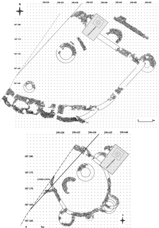
At the settlement of Porto das Carretas, various excavation areas were carried out, with roughly 10% of the occupied area being covered. The fortification of this settlement thus consisted of three lines of interrelated walls, resulting from a greater complexity and enlargement of the enclosed area (Soares, 2013). The first wall had a polygonal layout, similar to the first fortification of the settlement of São Pedro, with a large tower in the area where the wall formed an angle. The second wall, interpreted as a reinforcement of the previous one, consisted of a hollow circular tower. Only a few sections of the third wall remain, although the archaeologist responsible for the excavation proposes its reconstruction as a large circular structure. In the central area of this settlement, there is a large circular structure, apparently bordered by a wall, which may be interpreted as a tower-hut (fig. 10).
At the settlement of Monte da Tumba (Torrão), three major building phases were identified, with some internal subdivisions (Silva & Soares, 1987). The fortification built in Phase 1 consists of an oval wall, roughly 1.5 metres thick, and several semicircular towers roughly 7 metres in diameter. In Phase 2, a new wall was built, which overlapped with the previous one at various points, coinciding in its morphology and in the area that it marked out. This structure was composed of several semicircular towers smaller than those of the previous phase (roughly 4.5 metres in diameter) and some circular towers. Phase 3 of the occupation of this site involved building over the remains of the previous walls, together with the construction of a large circular tower in the centre of the elevation.
At the other sites, the excavated sample was very small indeed, although it displayed similar strategies.
At Monte Novo dos Albardeiros, there was evidence of a “...large semicircular tower, very probably linked to a complex defensive system” (Gonçalves, 1988-89:59), with attention being drawn to the conservation of a well preserved corridor providing access to the tower along a corridor. The lintel is also conserved.
The small intervention at Cerro dos Castelos de São Brás (Parreira, 1983:fig. 8) made it possible to identify some sections of two lines of apparently concentric walls and a large semicircular tower.
At the settlement of São Gens, only small sections of thick robust walls were iden-tified, Forming a fortified structure that marked out the top of the hill (Mataloto, 2005). The brief archaeological intervention at the settlement of Escoural (Gomes, 1991; Gomes et al., 1994; Soares & Cabral, 1993) made it possible to identify a fortified structure and a tower.
In recent excavation campaigns at the hillock of São Miguel da Mota (Alandroal) prehistoric materials and structures were identified (Rocha, in press). Despite their
Fig. 10.—Monte da Tumba (Torrão). Above, a general view. Below, towers showing partial overlaps and corrections to the layout of the wall (according to Silva & Soares, 1987, adapted).
poor state of conservation, it was possible to identify various segments of two lines of walls, which were quite possibly circular, and half of a tower.
The information that is available about the settlement of Monte do Tosco 1 (Mourão) does not really clarify whether there were any fortified structures here. In one of the excavated sectors, two parallel stone structures were identified (Valera, 2000:35-36) which may be sections of a wall, although the fact that the area examined was very small does not allow us to make any comments about its possible ground plan or size.
Although they were very uneven, the data presented for the different settlements enable us to make a few considerations. Immediately, we must stress that the fortifications of the first phases seem to have been the most robust and largest. The walls of these settlements are reinforced with various towers, most of which are hollow, which present large diameters in the first phases, becoming smaller in later phases. In some contexts, large circular structures were found, in the centre of the delimited area, which have been interpreted as towers, elements that are associated with a defensive structure.
The identification and description of the gates of most of these settlements is very succinct, which does not allow us to make many considerations about their specificities. The contemporary nature of the lines of walls at the various settlements that we have presented here is always problematical and difficult to confirm, considering that the walls were superimposed on one another and that their materials were reused, highlighting the fact that they had been deactivated. Monte da Tumba and São Pedro even show that their structures were reduced in size, namely the diameter of the towers. At most of the sites in the Alentejo, we noted the presence of large-sized central towers: 6 metres in diameter at São Pedro (Mataloto, 2010) and 5 metres in diameter at Porto das Carretas (Soares, 2013). If we use the calculations devised by M. Kunst and F. Arnold, we could hypothesise a considerable height for these structures, which would mean that they played a central role for the community because of the visual control that they offered of the territory. The stones from these large central watchtowers might have been partially reused in structures built in later phases.
THE SETÚBAL AND LISBON PENINSULAS An overview of the research
In the Portuguese region of Estremadura, the Chalcolithic period has frequently been associated with walls and fortifications, a connection that has a long history.
The 130 years of research that has been undertaken into the fortified settlements of Estremadura has accompanied the very history of archaeological thought in Portugal. Most of the walled sites were identified at the end of the 19th century, during a pioneering phase in Portuguese archaeology marked by the research of the Geological Services of Portugal, based on the collections of the National Museum of Archaeology and the studies of local researchers. The first research studies and publications thus date from a very early period, being concentrated mainly in the last few decades of the 19th century at Liceia (1878), Olelas (1878), Penedo do Lexim (1879), Pragança (1893), Rotura (1896), Outeiro da Assenta (1897), Outeiro de São Mamede (1895), Chibanes (1906) and Vila Nova de São Pedro (1929). The second phase was marked
by the discoveries by local amateurs of sites such as Fórnea (1931), Zambujal (1932), Penedo (1933), Pedra d’Ouro (1934), Ota (1932), and later Penha Verde (1957) and Outeiro Redondo (1966). Only two new fortified settlements were identified in the last quarter of the 20th century: Castelo (1987) and Moita da Ladra (1998) (figs. 11 & 12). Despite this long history of identifications, at most of the sites, only superficial samples were collected or preliminary excavations carried out. The available information is to be found scattered amid an extensive bibliography, but, in most cases, the archaeological records are old and insufficient.
These circumstances limit the range of our analysis to the three large settlements in Estremadura (Vila Nova de São Pedro, Zambujal and Liceia) and to some examples of small walled sites such as Penedo do Lexim, Moita da Ladra or Outeiro Redondo. The other known sites mentioned above will be included in our general analyses.
It should be stressed that it is in Estremadura that one can find the largest concentration of walled sites in the west of the Iberian Peninsula: 18 fortified settlements for an area of roughly 4000 km2: practically one “fortification” for each of the
present-day administrative municipalities in this region, which has frequently led to territorial analyses and hierarchical readings of the settlement.
This relative concentration is further reinforced by the virtual absence of ditched sites, with only a few scattered and insufficiently characterised instances being recorded at Gonçalvinhos (Sousa, 2010), Santa Sofia (Pimenta et al., 2013) or Travessa das Dores, Lisbon (currently under study).
A possible vision of the violence seen through the walls of Estremadura and other contexts
In Estremadura, we may consider that the interpretation of the walls has been guided by two broad perspectives. On the one hand, the question of the origins of the builders of the walls seen according to the dialectic of indigenism versus diffusion (see for exemple Gonçalves et al., 1983-84; Jalhay & Paço, 1945:263; Sangmeiester & Schubart, 1981:20). On the other hand, one should stress the defensive and offensive perspective that the main authors have adopted for the interpretation of the walls, namely for Zambujal, the german School of the DAI (Deutsch Archaeological Institut), with H. Schubart, H. Sangmeister, and recently M. Kunst. Also the interpretation put forward by other authors such as J. L. Cardoso for Liceia (Cardoso, 1997), C. T. Silva and J. Soares for Chibanes (Soares, 2003) or one of the authors of this paper (ACS) for Penedo do Lexim (Sousa, 2010) proposes a defensive function for these structures. The post-processualist movements that denied the “warlike” nature of the walls, and which swept across the northern territories, fortunately never reached as far as Estremadura… nor indeed any other site in the south of the Iberian Peninsula.
The appearance of the first walls is therefore interpreted within a context of social and economic transformation. Authors such as M. Kunst (Kunst, 2001; Kunst & Arnold, 2011) highlight the question of violence, pointing to the proliferation of arrow heads and referring to cases of violent deaths such as the necropolis of San Juan ante Portam
Fig. 11.—Outeiro Redondo (Sesimbra) in its initial phase of excavation (according to Cardoso, 2010b).
Fig. 12.—Moita da Ladra (Vila Franca de Xira) (according to Cardoso & Caninas, 2010, and according to spoken information provided by J. L. Cardoso, a late fortification).
Latinam (Etxeberria & Vegas, 1988): “All indications point to a tumultuous period, during which there was an accumulation of belligerent conflicts” (Kunst & Arnold, 2011).
Looking at the question from the point of view of so-called social archaeology, authors such as Joaquina Soares recognise a scenario of great conflict in Estremadura: “The potential for conflict was to be exported on a supracommunity scale. “Generalised” war was like that: it was the price that was paid for resisting the centralisation of power. Each settlement was to take responsibility for its own defence” (Soares, 2003:168). Other authors either implicitly or explicitly refer to the “arrival of Mediterranean influences by land and sea” and shocks with the indigenous people, a reading that is to some extent corroborated by Victor S. Gonçalves (Gonçalves, 1995:315), João Luís Cardoso (Cardoso, 1997:16) and Ana Catarina Sousa (Sousa, 2010).
Various indicators seem to confirm that the appearance of fortifications in the Estremadura region occurred at a time of profound social change, and also of instability, a reality that is borne out by the aforementioned indicators.
Models of implantation
On a territorial scale, we may consider that there was a radical change in the patterns of occupation, with open and dispersed implantations being practically abandoned and with fortified settlements being exclusively concentrated at high points with great visual control over the surrounding territory and good access to necessary resources. Even though there have been great differences in the pace of research into the two peninsulas of Lisbon and Setúbal, the systematic research undertaken in concrete areas such as the valley of the River Sizandro (Torres Vedras) or the river basin of the Ribeira de Cheleiros (Mafra and Sintra), this seems to highlight the concentration of the settlement of that area at the beginning of the third millennium in sites built on high ground and with fortifications and the progressive abandonment of the settlement in open areas that could not be easily defended (Sousa, 2009; 2010).
There is no one single model relating to types of implantation in terms of the natural defensibility of fortified sites: “clear” areas without any strong marks of the geological substratum, such as Zambujal, Liceia or Vila Nova de São Pedro; and small sites where the architectural model is predetermined by the existing geological substratum, as is the case with Penedo do Lexim, Penha Verde or Pragança (figs. 13 & 14).
Chronologies and discontinuities in occupation
We find distinct situations as far as pre-existing Neolithic occupations at these fortified settlements are concerned. In only three cases do we clearly find quantitatively significant levels of evidence from the late Neolithic period: Liceia, Olelas and Penedo do Lexim. The case of Liceia is paradigmatic, since the sequence of absolute datings enabled us to statistically identify a hiatus in the region’s occupation between the levels of the late Neolithic period and those of the early Chalcolithic (Cardoso & Soares, 1996), allowing us to make possible inferences of stratigraphic continuity. In the case
Fig. 13.—The successive series of fortifications at Liceia (Oeiras) (according to Cardoso, 2010a). In the drawing published by J.L. Cardoso, we removed all the constructions inside these defensive lines and gave them new keys, so that this image is now a new proposal. T: Tower (followed by the designation attributed by J. L. Cardoso); Pt: Gate; Ri: Inner reinforcement of the wall; TA: Watch tower; Cb: Hut?. What is very interesting here (and deserves to be discussed) is the fact that the towers TEO, TEI (?), TEP, TEU and TEX opened onto the area outside (or not?). Also in this line of walls, Gate EH presents two reinforcements on either side, which were uncommon in other settlements. Because of its arrangement and even its integration into the whole, MM was considered as a watch tower, similar to the one at Monte da Tumba. Hut ZZ is very similar to Hut 7 of Cabeço do Pé da Erra (Coruche), a farm overlooking the River Sorraia, protected by a large ditch, dating from the second half of the third millennium BCE. Tower XX1 could be similar to Tower 3, at Santa Justa, a tower from the second building phase, protecting a gate.
of Olelas and Penedo do Lexim, the absolute chronology does not clearly establish the sequence, but it does reveal pre-existing situations. For Vila Nova de São Pedro, there seems to have existed an ex novo form of occupation (see Gonçalves et al., in press). In the case of Zambujal, the new works undertaken on the fourth line may indicate a phase of occupation that immediately preceded the first fortifications also dated within the same time frame (Kia-7260; bone; before 1 – Line 4; 4134 ± 43 BP, 2875-2581 2 σ cal BCE). No dates are known prior to the third millennium nor any materials that can be regarded as fossils pointing towards the late Neolithic in the Estremadura region (carinated bowls and serrated rims).
The beginning of the Chalcolithic occupation of the fortified settlements of Estremadura is concentrated into the second century of the third millennium, with the upper end of this time interval being around 2890 to 2880 Cal BCE, with some exceptions such as
Fig. 14.—Olelas (Sintra) (according to Marques Gonçalves, 1997). It includes the towers, initially consi-dered to be tholoi by Serrão & Vicente (1959).
those settlements founded at a later date, such as Penha Verde or Moita da Ladra, in the middle of the third millennium. Everything indicates that the change in the model of implantation and the onset of fortified settlements corresponds to a very rapid process, a circumstance that seems to corroborate the idea of social instability.
Defensive architectures
The interpretation of the architectures of the fortified settlements of Estremadura is limited to a very small number of sites with overall ground plans: Vila Nova de São Pedro, Zambujal, Liceia, Moita da Ladra. The universe is even smaller if we restrict ourselves to sites with information about separate architectural and occupational phases, something that was lacking in Vila Nova de São Pedro, and was only extremely partial in the case of other fortified settlements that were excavated, namely Penedo do Lexim, Olelas, Pragança, Outeiro de São Mamede, Fórnea, Chibanes, Penha Verde, Pedra d’Ouro.
For these sites, we can broadly consider that the first building phase generally obeyed the overall strategic plan, and that it apparently corresponded to the greatest area of building work. This perception of a plan has been stressed in the case of Liceia, for example: “The construction of such a complex system, and all in one go, suggests, on the other hand, that there was a pre-conceived and methodically implemented plan, and that, during a reasonable period of time, it was used for defensive purposes by those who had promoted its construction, which was, after all, the justification for such a grandiose work” (Cardoso, 1994:32).
Only the fortified settlement of Zambujal does not fit into the general model of fortifications with an oval ground plan, which can broadly speaking be applied to Moita da Ladra, Liceia, or, hypothetically, Olelas and Penedo do Lexim (these two settlements having been subjected to only partial excavations). At Zambujal, there is a ground plan that denotes the overlapping of subcircular areas with compartmentalisations of parallel walls, creating an image of a ground plan with angles. In fact, it should be stressed that, in the evolutionary ground plans drawn up for Zambujal (Sangmeister & Schubart, 1981; and, more recently, Kunst, 2010), the first phase is the one that is least represented, with there being large sections of wall that correspond to hypothetical axes. There is also a clear correlation between the ground plans and the geomorphological setting of the sites. In the case of Liceia, the rocky escarpment situated to the west dispensed with the need to build a defensive line, which was only built for the eastern half. In the cases of settlements implanted in rocky areas, a clear use was made of natural elements, with the walls being adapted to the spaces between outcrops. This was the situation at Pragança, Penha Verde, Outeiro de São Mamede, and, of course, Penedo do Lexim. As far as this last site is concerned, there is a correlation between the natural and the built elements, with the vertical basalt outcrops being substantially more monumental than the walls that were built in the more vulnerable areas. Despite this, the placement of isolated obstacles (sections of wall in areas of easier access or where there are gullies), without any integrated ground plan, has never been detected, so that it would seem clear that the main purpose of these building works was to enclose an area (figs. 15, 16 & 17).
Fig. 15.—Aerial photograph of Penedo do Lexim and the immediate surrounding area, with a prehistoric human occupation (according to Sousa, 2010).
Fig. 16.—Solid tower in Sector 5 of Penedo do Lexim, on the east slope (according to Sousa, 2010). Below, the collapse of part of the tower.
The concept of successive lines of wall is applicable above all to the large settlements such as Liceia, Vila Nova de São Pedro and Zambujal. Attention is drawn in particular to Zambujal, since the work recently undertaken there has made it possible to identify a fourth line (Kunst & Uerpmann, 2002), altering the previous model of three lines. In some cases, we may put forward the hypothesis of the existence of just a single line, as at Moita da Ladra, which has already been fully excavated. We might therefore consider a model of large settlements with successive lines of walls that lasted for a long time and small settlements, such as Moita da Ladra, Olelas and Pragança, lasting for a shorter period of time and having just one defensive line.
There are, however, exceptions. At Pedra d´Ouro, where the “…area protected by walls was much larger than that which is defined by the trapezoidal structure that was initially published” (Gonçalves, 2003:307), the site developed in width, adapting to the morphology of the terrain, without a strictly concentric logic. At this site, in the 1973 excavations led by Victor S. Gonçalves, a large hollow tower was discovered backing onto the “mauer 3” of the German archaeologists, who had previously revisited the site (Leisner & Schubart, 1966). In the case of Penedo do Lexim, a small settlement, the excavations made it possible to confirm the presence of two definite lines and a probable third one.
With only partial information available for the ground plans, our reading of the defensive nature of the fortifications of Estremadura is naturally centred on the other two key elements in any fortification: the geometry of the gates and the towers.
As far as the gates are concerned, we only have clear information for the large fortified settlements.
In Liceia, by observing the model of implantation of the defensive system in the rocky platforms (Cardoso, 1997:31), we can note the existence of three gates in the outer enclosure, facing towards the areas where there are no gullies. Among the gates, attention is drawn to E6, which belongs to the category of a flanked gate with the presence of “…two rectangular towers, probably related with the installation of a wooden gate” (Cardoso, 1997). However, in the interpretation of the general layout, some of the towers implanted in the third defensive line record the presence of exterior entrances, although there is no information available about the phase during which these would have been created and used. Mention should also be made of the close links between the circulation and the gates, with emphasis being laid on the presence of paved surfaces at the entrances (Cardoso, 2000:93): “...two main lines of circulation have been identified inside the walls, one facing northwards, and successively passing through the first, second and third lines of walls, and the other facing southwards, relating to two entrances, one situated in the innermost defensive line and the other in the outer one …” (Cardoso, 2000:95).
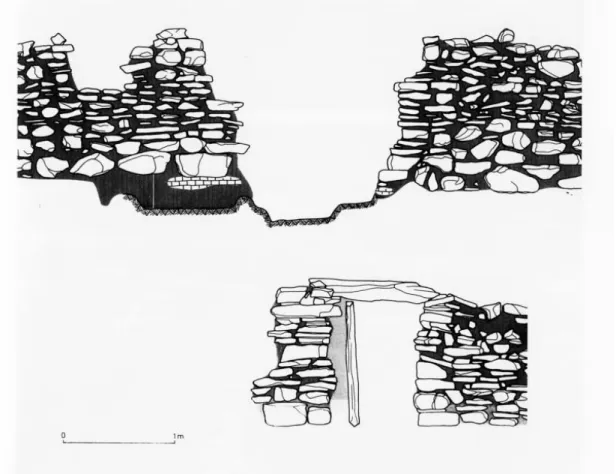
Zambujal presents a complex group of walls, with various entrances, for which an elaborate defensive strategy has been proposed. Mention should be made of the gate leading to the inside of the central redoubt: “A corridor, just one metre wide, leads to the fortified core, passing through the wall at a point where this reaches a height of 13 metres” (Schubart & Sangmeister, 1987:135). This is perhaps a dissimulated gate, since the layout is not a right-angled one and does not allow for direct visibility of its interior (figs. 18, 19 & 20).
Fig. 18.—Zambujal (Torres Vedras). Proposal for the different phases of the defensive system (according to the proposal put forward by Sangmeister & Schubart, 1981, developed in Kunst, 2010).
Fig. 19.—Zambujal (Torres Vedras). Aspect of the dynamics of the reconstruction of the defensive system between the first and the second line of walls, including the “barbican” (according to Kunst & Arnold,
Fig. 20.—Zambujal (Torres Vedras). Proposal for the reconstruction of Tower B (according to Kunst & Arnold, 2011).
The excavation undertaken at Vila Nova de São Pedro is difficult to read clearly, but it seems that the entrance to the central enclosure might have been reinforced with a tower, corresponding to the model of a flanked gate. Attention is drawn to the small width of the entrance to the main enclosure.
At Moita da Ladra, a hypothetical entrance flanked by a tower (Cardoso & Caninas, 2010:73) has been identified, together with another paved one (A1) between sections of the wall. Observation of the ground plan and the pictures (Cardoso & Caninas, 2010:fig. 12) does not clarify what type of entrance this was.
As far as Estremadura is concerned, it can be seen that towers were to be found in almost all of the contexts of fortified settlements, with the exceptions being S. Mamede
and Fórnea. The number of hollow towers and solid towers was relatively balanced, although there were slightly more of the former.
At Vila Nova de São Pedro, the available information makes it difficult to interpret the settlement, although it is clear that in the inner enclosure all the towers were solid ones (Gonçalves, 1993:231), which is not the case with the second line of walls. In the third line of walls, in the section excavated by Victor S. Gonçalves, there were no towers protecting the gate that was identified (Gonçalves, 1993:131).
At Zambujal, the sequence begins with solid towers. A recently published study by Miguel Kunst and Felix Arnold makes a very rigorous and well-grounded proposal about the reconstruction of the towers of Zambujal. This site’s excellent state of conservation, which makes it one of the most remarkable one Chalcolithic villages of the Iberian Peninsula in terms of the actual height that has been conserved, allows for the presentation of concrete proposals for the reconstruction of the towers. The elevation of the towers even includes the beginning of the vaults, which enables us to make some exact calculations: “Vaulted ceilings in the form of a false dome were particularly appropriate for areas that were below 2.5 metres in height. (…) Provided that the arch began immediately at the foot of the wall, a vaulted ceiling with a false dome might make sense in a space that was up to 3 metres in width. Thus spaces with a width of 3 metres would acquire an acceptable height of 3.3 metres. But working with a larger space would already result in a disproportionately greater height, for example. 3.5 metres would require a height of 5.5 metres and a space of 4 metres would require a height of 9 metres” (Kunst & Arnold, 2011:472-573). These calculations lead the authors to propose that the towers had a second fl oor, with ceilings that were probably made of organic material (Kunst & Arnold, 2011:476) considering the complexity of the keystones of the vault. For the solid towers, the hypothesis is also put forward that there was an upper platform. The existence of upper fl oors in the towers is also proposed for Los Millares (Molina & Cámara, 2005).
At Liceia, with the first building phase, there simultaneously appear solid towers in the second line of walls and hollow towers in the third line. If we consider that the various defensive lines of Liceia or Zambujal were contemporary with one another, it is even more difficult to understand the proximity of turrets positioned in the inner lines. The presence of a tower at Penedo do Lexim is the most eloquent indication of the same defensive architectural concept, so that it is diffi cult to conceive of a non-defensive function for this structure. The line of walls and the turret detected halfway up the eastern slope of Penedo do Lexim are positioned in an area where there is very little visibility over short distances, which seems to indicate a possible strategic function for this structure (fi g. 16). In a site where the removal and reuse of stone blocks would be a complex affair in view of their size and the uneven and hilly terrain of the various platforms, the building of a turret at Penedo do Lexim certainly called for a great community effort.
Reconstructions and remodellings
Resulting either from natural or man-made causes, there were reconstructions and remodellings of the defensive system at all the fortified settlements with modern archaeological records.
As far as remodellings are concerned, the different phases occurring at Zambujal and Liceia are well documented.
For Zambujal, H. Schubart and E. Sangmeister established an architectural evolution that involved five main phases, which are, in turn, divided into sub-phases. This model was adopted and developed by M. Kunst, who attributes a clear “warlike” function to these structures, with very distinct building programmes. Phase 1 corresponded to a model of narrow walls with solid semicircular towers and smaller radial walls (Sangmeister & Schubart, 1981:227), Phase 2 corresponded to the creation of the defensive system of a barbican and to the system of successive lines of walls; Phase 3 is described as the “solid phase” (Sangmeister & Schubart, 1981:237-242) and Phases 4 and 5 involved a concentration of the occupation of the settlement and the construction of hollow semicircular towers in the first line of walls.
A plan has been developed at Zambujal (figs. 18 & 19) for the dating of samples with a short life, but these dates have not made it possible to establish a clear chronological correlation of the various phases, with the great stratigraphic complexity of the site reflecting the difficulty in dating these types of reality.
For Liceia, it is proposed that three main periods should be identified (late Neolithic, early Chalcolithic and middle Chalcolithic), which correspond to four building phases of the defensive system and different domestic uses (Cardoso, 2010). In the early Chalcolithic period, there were building phases related with the defensive system: in the first one, the basic system was built, with “three walled lines, arched and sub-parallel, defended and reinforced on the outside by semicircular towers, which were generally hollow” (Cardoso, 2010:50); in the second phase, there were “reinforcements and improvements”, designed to make them higher (Cardoso, 2010:51), and in the third phase, new towers were built and the width of the entrance was shortened in the third line of defence. In the middle Chalcolithic period, abundant domestic structures appeared, sometimes backing onto the wall or built amid its demolished parts (fig. 13).
We therefore have a building phase which in Liceia was one of general reinforcement, whereas in Zambujal it involved a change to the overall programme. This duality may in some way reflect the interpretations made by their excavators, in the case of Zambujal with a perspective that was clearly geared towards the fortifications of the “colonies” of metallurgists. We may, however, identify one constant feature, with the widening of the walls and the concentration of the settlement in a central redoubt. In other sites too, such as Vila Nova de São Pedro, there seems to have been a contraction of the occupied area in the middle of the third millennium, in what has come to be known conventionally as the middle Chalcolithic period (figs. 21 & 22).
As far as repairs or remodellings are concerned, these were found to have taken place at all the sites with a detailed archaeological record, highlighting the fact that the defensive systems present a dynamic in their use and appropriation that reveals the ongoing social instability that gave rise to their initial implantation. The repeated collapses of the walls, their horizontal stratigraphy and the rapidity with which they were repaired make their interpretation more complex and present enormous challenges in recording and interpreting the field data.
The excellent exercise of reconstituting the stratigraphies and forms of construction identified for Zambujal (Kunst & Arnold, 2011) highlights the importance of a precise