E-walknavi: Walk Route Navigation System
For Fitness Walkers Using
Calorie Consumption Prediction
Yuki Sakon, Hung-Hsuan Huang, and Kyoji Kawagoe
Abstract—In this paper, we propose a novel walking route navigation system for fitness walkers effective for health main-tenance. Recently, lifestyle-related disease has been increasing in the world. It is important for people to keep balance between the calorie intake and the calorie consumption. We focus on calorie consumption by walking, because walking is on effective exercise for maintaining and promoting healthy life. It is necessary to select a walking route, appropriate for calorie consumption. Our system described in this paper, called E-walknavi, can dynamically navigate an effective route in real time when a user is walking. To realize this novel navigation function, a method of dynamically predicting calorie consumption is also described in this paper. Our system helps a fitness walker prevent lifestyle-related diseases. Some evaluation results are described in the paper.
Index Terms—health science, walking navigation system, METs, time series, calorie prediction.
I. INTRODUCTION
T
HE influence of lifestyle-related diseases is of world-wide increasing concern. It is important for people to maintain a balance between their calorie intake and calorie consumption. Because moderate exercise is necessary to health, walking is one of the most effective exercises for maintaining and promoting healthy life of all sports. Walking can be done at any time of day and can be performed at your own pace. Several important research studies [1][2][3][4][5] have been performed on the promotion of walking exercise with the help of computer technology.For example in [4], the authors used a device that can calculate a user calorie consumption using a 3-axis ac-celerometer of the device, attached to the body. However, none of the existing devices include an important function of predicting calorie consumption while a user is walking.
If a system or a device can predict consumed calorie dynamically, we can select a walking route in order to burn calorie effectively and can improve health care.
There are several web services that can easily calculate calorie consumption with the input of the total distance walked by a user [6][7]. However, the accuracy of the method implemented in these web services, is poor because it does not take account of the route elevation, walking speed, the user’s walking characteristics, and fatigue characteristic. In order to select a walking route for effective calorie consumption, we realized an accurate prediction of calorie consumption before walking [8].
Manuscript received January 23, 2014; revised February 2, 2014. This work was supported by JSPS KAKENHI Grant Number 24300039.
Y. Sakon is with the Department of Information science and technology, Ritsumeikan University, Japan, e-mail: is019085@ed@ed.ritsumei.ac.jp
H.H Huang and K. Kawagoe are with Ritsumeikan University.
In this paper, we propose a novel system of predicting calorie consumption based on the method proposed in [8].
The point of our system is to enable users to present a new route from the data acquired in previous walking with use of the method of calorie consumption prediction.
Therefore, a user can find a new route between the current spot and the destination with the maximum calorie con-sumption per unit time. We describe herein a walking route navigation system of a new route enabling the maximum calorie consumption per unit-time in real time when a user does walking exercise.
II. RELATED WORKS
In this section, we describe existing systems as well as Metabolic Equivalent Task called METs.
A. Free Walking Calorie Calculator Tool
A web service tool, called Free Walking Calorie Calculator Tool [6], predicts calorie consumption when a walking path with the total walking distance is specified. After a user inputs walking pace, user weight, walking time and route elevation, the service gives the user the predicted calorie consumption. Although this service is similar to our own, this service is not effective when a user change his/her walking speed frequently. the user’s walking characteristics, and fatigue characteristic.
B. Kyorisoku
A web service tool, called Kyorisoku [7], predicts calorie consumption when a walking path with the total walking distance is specified. A user inputs the start spot and the goal spot. Then, the service displays food intake that corresponds to the predicted consuming calorie. However, the user can only use this service after or before walking. So, this service can’t dynamically navigate an effective route in real time when a user is walking.
C. METs
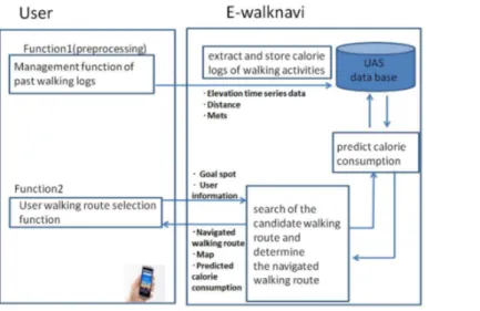
Fig. 1. The structure of E-walknavi
than is needed at rest. Ainsworth defined the METs for each exercise [10]. The amount of calories burned can easily be calculated using the METs values and the equation proposed by the American College of Sports Medicine (ACSM) [9]. The calorie consumption value is a function of the METs/h value and the subject’s body weight, as shown in the equation below.
Calorie Consumption= 1.05·M ets·hours·body weight
(1)
III. E-WALKNAVI
We developed the E-walknavi. In this section, we explain the system details.
A. Purpose
The purpose of our system is to dynamically navigate the walking route. We use of the proposed method of predicting an effective calorie consumption in consideration of the characteristic of the user in real time when a user does walking exercise.
B. Function and the structure
E-walknavi has the following two functions.
• Management function of past walking logs: This func-tion extracts and stores user’s past calorie logs of walk-ing activities in the format of time series. The system collects walking data with the help of smartphones. Then, the system stores these time series in a UAS database, described below.
• User walking route selection function: with the function, a user can obtain his/her walking information and the most effective walking route.
Fig. 1. shows the structure of E-walknavi system based on the method described below. Using this figure, the process of route navigation is described below.
The system first calculates a user’s METs by using a 3-axis accelerometer and acquires the position time series data for
Fig. 2. Photograph of the E-walknavi(1)
the user’s walk from the user’s past movement. We extract the METs in the position time series data in every△T minutes. A calorie consumption prediction method should take into consideration of the four factors: elevations, user’s walking characteristics, walking speed and fatigue characteristic.
A user of the system starts walking exercise after inputing of the goal spot and user information. E-walknavi works at the same time as the user walks. E-walknavi calculates user walking speed and current spot. E-walknavi searches the candidate routes more than N from the current spot to the goal spot. Next, the system predicts the calorie consump-tions of N routes using our predicted calorie consumption prediction method. The system calculates a weight between two spots calledE-valueusing predicted calorie consumption and current walking time.
C. UAS database
We extract and store calorie logs of walking activities in a format of time series, beforehand. The obtained data is stored in User Action State (UAS) database.
The walking route includes attitude and distance informa-tion. The walking route is represented by a trajectory which is a temporal sequence of<distance, elevation>.
UAS database has the elevation time series data, distance data and exercise intensity data. Elevation time series data is acquired from GPS. Distance data is acquired and calculated from the degree of latitude and longitude by using Hubeny’s distance formula [11]. Exercise intensity data (METs) is acquired from 3-axis accelerometer data.
D. Examples
We describe here examples of our system usage, using Fig.2 and Fig.3. Figure 2 shows an output after the user’s input. A user inputs the goal spot and user information such as user’s weight. The user can ask the system to predict calorie consumption any number of times, at any time as shown in Fig. 3.. Once the user knows the benefit of walking for exercise, the user is more motivated to walk because it is beneficial. When the user approaches the forked road, the system displays the predicted calorie consumption in real Proceedings of the International MultiConference of Engineers and Computer Scientists 2014 Vol II,
IMECS 2014, March 12 - 14, 2014, Hong Kong
ISBN: 978-988-19253-3-6
ISSN: 2078-0958 (Print); ISSN: 2078-0966 (Online)
Fig. 3. Photograph of the E-walknavi(2)
time as shown in Fig. 4.. Predicted calorie consumption values vary with walking distance, walking speed, walking time, walking elevation, walking characteristics, and fatigue characteristic. So, the system selects a route according to predicted calorie consumption dynamically.
Our system was implemented using an Android smart-phone terminal so that the user does not need to attach an ad-ditional device. Android applications are developed using the Google Map Android API V2. The database is constructed on the built-in Android system by using SQLite, which makes it possible to operate our system as an independent application rather than on a server.
• The arrow indicates the way to go. • Predicted calorie consumption
• Elapsed walking time up to the current time • Calorie consumed up to the current time • Distance to the destination
IV. CALORIE CONSUMPTION PREDICTION AND WALKING DYNAMIC NAVIGATION
We developed the system that navigates the most effective route dynamically, in order to realize dynamic navigation according to calorie consumption. Our system is provided to solve these issues. The basic ideas of our proposed system are described here.
Before walking, time series data of the past routes which are all similar to the time series of the walking route are searched with use of peculiarity similarity definition. The calorie consumption is estimated from these past walking time series.
Moreover, the goal spot are decided in the determination of walking route beforehand. There are candidate walking routes to the goal spot from the current spot. The system calculates walking speed from GPS and predict calories consumption of the candidate walking route. The system navigates the most efficient walking route in a candidate route.
A. A calorie consumption prediction
In our proposed method, predict calorie consumption pro-cess is conducted as follows:
Fig. 4. Photograph of the E-walknavi(3)
Step-1 The system calculates walking speed from GPS. Step-2 Elevation time series data and predicted distance
after every S min are calculated with regard to the walking speed.
Step-3 The similarity with the User Action State (UAS) database’s elevation time series data is calculated. Then, using the K-nearest neighbor (K-NN) algo-rithm the average METs and the average distance are obtained from the UAS database.
Step-4 A total calorie consumption is calculated from the METs and distance acquired in STEP-3.
B. Finding similar past walking routes
In order to predict calorie consumption for a new path that takes the three factors into account, we first obtain the amount of calories to be consumed for the next P minutes from the current time. All the calorie consumption values that had been predicted up to current time for eachP ×S
minute interval were collected and added. The route forP×S
minutes is called a route segment. Each route consists of small route segments. It is assumed the time interval of a route segment is constant, S minutes. Routelj is a sequence
of route segments, route lj =< e1, e2, e3, ... >. We obtain
the previous route that is most similar to the new route by using the following distance definitions d(lnew,llog), the
distance between a new routelnewand one of the past routes
llog as follows.
d(lnew, llog) = Σj|△Elevation(enew,j)
−△Elevation(elog,j)| (2)
where enew,j and elog,j are route segments for a log
route and a new route, respectively.△Elevation(ek)is the difference between the elevation of the current spot and the elevation of the goal spot for route segmentek.
C. Calorie consumption prediction using K-NN and the split time-series data
the routes by a K-NN search from the UAS database, the average calorie consumption values for the different routes are calculated and the predicted calorie consumption values are tabulated. The total predicted calorie consumption is calculated by adding all the predicted calorie consumption numbers for the route segments. The calorie consumption for a route is calculated using the equation proposed by the American College of Sports Medicine [9]. It can also be determined using an hourly MET value and the user’s weight. Also, In order to take into account the fatigue characteristic of the user, we divide into the UAS database into ”early stage”, ”middle stage” and ”final stage” . We calculate the degree of similarity of each stage.
D. Dynamic navigation
In our system, a dynamic walking route navigation process is conducted as follows:
Step-1 The system obtains user’s current spot. Then, the system searches for the candidate routes more than
N between the current spot and the goal spot. Step-2 The system predicts the calorie consumption of
N routes using the predicted calorie consumption methods in the following steps.
Step-3 The system calculates a weight between two spots calledE-valueusing predicted calorie consumption and predicted walking time. The above process is conducted every several seconds. Our initial setting for this interval is pre-defined. Therefore, the system can dynamically present a user a new route from the current spot to the goal according to possible calorie consumption as well as current consumption.
The system searches the N candidate routes from the current spot to the goal spot. We extract a candidate walking route from Google Maps. The candidate walking route is assumed to be a route using a pedestrian precinct and the sidewalk on foot a candidate route in Google Maps and acquires elevation data. Afterwords, When a user approaches the forked road, the system sets A the current point and sets B the goal spot. We extractN candidate walking routes between A and B. Predicted calorie consumption values vary with walking distance, walking speed, walking time, walking elevation, walking characteristics and fatigue characteristic. So, the system selects a route according to predicted calorie consumption dynamically.
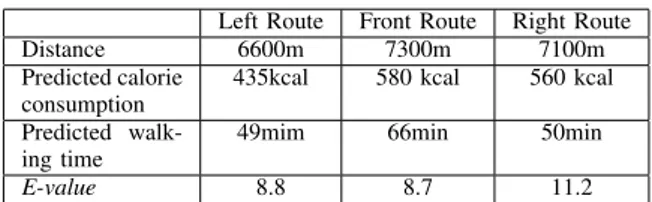
For example, it presents three routes with a left route, a front route, a right route.
The system calculate predictive calorie consumption us-ing function to predict calorie consumption in the walkus-ing route. The system calculateE-valuebetween two spots using predicted calorie consumption and current walking time. The
E-value of the route between two spots is a function of the predicted calorie consumption and current walking speed, as shown in the equation below.
E−value= predicted calorie consumption
predicted walking speed (3)
The system calculates predicted calorie consumption val-ues vary with walking distance, walking speed, walking
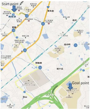
Fig. 5. To Minami-kusatsu station from Ritsumeikan (BKC)
time, walking elevation, walking characteristics, fatigue char-acteristic. Whenever user approaches the forked road, the system calculates predicted calorie consumption. The system selects a route according to predicted calorie consumption dynamically.
V. EVALUATIONS
A. Setup
Five subjects stored their UAS database in their smart-phones for seven days and acquired the elevation time series data of total 360 minutes during seven days. We considered a crossing of the route as a node. We connected the shortest distance between nodes and found all the routes as candidate routes.
B. Experiments
We set Minami-kusatsu station the start spot and set Ritsumeikan University the goal spot (Fig. 4.). We performed three experiments: the e-value experiment, the E-value exper-iment on navigated routes, and the experexper-iment on accuracy of calorie consumption prediction. The results of these three experiments are described below.
In the latter two experiments, we compared our results with the two existing systems: Free Walking Calorie Cal-culator Tool (existing system(1)) and Kyorisoku (existing system(2)). These systems do not take account of the route elevation, walking speed, the user’s walking characteristics and fatigue characteristic.
C. Evaluation of E-value
Table I shows our findings. It shows the distance, the predictive calorie consumption, the predictive walk time and
E-value for each route. When a user approaches the forked road, our system can navigate the right route whoseE-value
is the largest among the three routes. Proceedings of the International MultiConference of Engineers and Computer Scientists 2014 Vol II, IMECS 2014, March 12 - 14, 2014, Hong Kong
ISBN: 978-988-19253-3-6
ISSN: 2078-0958 (Print); ISSN: 2078-0966 (Online)
Distance 6600m 7300m 7100m Predicted calorie
consumption
435kcal 580 kcal 560 kcal
Predicted walk-ing time
49mim 66min 50min
E-value 8.8 8.7 11.2
D. Evaluation of navigated route (1)
Five subjects walked to Ritsumeikan University (the bot-tom right spot shown in Fig. 5) from Minami-kusatsu (the top left spot) at an approximately constant speed (6 km/h), the walking distance one-way was about 3,300 m and the difference in elevation was 52 m. We predicted the calorie consumption for a new unknown walking route by using our method, the Free Walking Calorie Calculator Tool [6] and Kyorisoku [7]. We calculated theE-valuebetween two spots using predicted calorie consumption and predicted walking time. We also calculate each modulus as correct answer data of real E-values.
We used the following navigated route’s appropriateness (RRA) formula for evaluation. This number indicates that the smaller one has good appropriation.
RRA=1
N×Σi
|P redictedE
−value(i)−ActualE−value(i)|
ActualE
−value(i) (4)
whereP redictedE−value(i)is a predicted value ofE-value
forsubjecti.ActualE−value(i)is an actual value ofE-value
for subjecti, andN is the number of subjects.
Table II shows the results of this experiment. As shown in Table III, the RRA was about 0.8% for our method and about 23.5% for the Free Walking Calorie Calculator Tool system (existing system(1)) and about 29.3% for the Kyorisoku (existing system(2)).
Therefore, the navigated route’s appropriateness of our method is superior to those of the existing web services.
TABLE II RESULTS OF THEE-value
Actual E-value
E-walknavi
Existing system(1)
Existing system(2)
Subject1 9.61 9.44 7.02 7.50
Subject2 7.48 7.63 4.71 5.35
Subject3 6.31 6.20 4.97 4.43
Subject4 6.63 6.41 5.57 4.96
Subject5 7.2 6.98 6.00 4.21
TABLE III RESULTS OFRRA
E-walknavi Existing system(1) Existing system(2)
RRA 0.8% 23.5% 29.3%
E. Evaluation of navigated route (2)
We extracted the following routes from the candidate walking routes. N odek is a node representing a
in health maintenance. Our system can navigate the walking route which can use an effective calorie in consideration of the user walking speed, the user’s walking characteristics, fatigue characteristic in real time when a user does walking exercise. The accuracy seems to be enough to obtain credible numerical values for calorie consumption. In the future, we plan to perform more detailed and subjective evaluations. Further, another issue is the improvement of user interface, for example, the introduction of an agent based interface may help to improve the usage of the system.
ACKNOWLEDGMENT
This work was partially supported by JSPS KAKENHI Grant Number 24300039. We would like to thank Professor Kiyoshi Sanada and Professor Motoyuki Iemitsu for giving us a great deal of information on sports and health science.
REFERENCES
[1] Lara, O. D., Perez, A. J., Labrador, M. A. and Posada, J. D.: Centinela: A human activity recognition system based on acceleration and vital sign data, Journal on Pervasive and Mobile Computing (2011) [2] U. Varshney, Pervasive Healthcare and Wireless Health Monitoring,
ACM/Baltzer Journal of Mobile Networks and Applications, Vol.12, No.2-3, pp.113-127 (2007).
[3] Neil Zhao.: Full-Featured Pedometer. Design Realized with 3-Axis. Digital Accelerometer Analog Dialogue Vol.44-06, 1-5, June (2010) [4] Kawahara, Y., Ryu, N., and Asami, T.: Monitoring Daily Energy
Expenditure using a 3-Axis Accelerometer with a Low-Power Mi-croprocessor. International Journal on Human-Computer Interaction, Vol.1(No.5), 145-154 (2009)
[5] Sumida, M., Imazu, S., Mizumot, T., and Yasumoto, K.: Estimation of Perceived Exertion using Smartphone for Health-Conscious Walking Navigation, IPSJ SIG Technical Report, Vol.2012-MBL-62, 1-8 in Japanese (2012)(in Japanese)
[6] Free Walking Calorie Calculator Tool, https://www.everydayhealth.com/ [Accessed 3rd February 2014]. [7] Kyorisoku, https://http://www.mapion.co.jp/route/ [Accessed 3rd
February 2014].
[8] Sakon, Y., Huang, H.H., Kawagoe, K.: Walk Route Recommendation for Fitness Walkers Using Calorie Consumption Prediction. Smart Health. Lecture Notes in Computer Science Volume 8040, 122-133 (2013)
[9] American College of Sports Medicine, http://www.acsm.org/ [Ac-cessed 3rd February 2014].
[10] Ainsworth, B. E., Haskell, W. L., Whitt, M. C., Irwin, M. L., Swartz, A. M., Strath, S. J., O’Brien, W.L., Bassett, D. R. Jr, Schmitz, K. H., Emplaincourt, P. O., Jacobs, D. R. Jr, and Leon, A. S.: Compendium of Physical Activities: an update of activity codes and MET intensities. Med Sci Sports Exerc. Vo.32, S498-504 (2000)
[11] Haraki, T., Yokoyama, S., Fukuta, N., and Ishikawa, H.: On Gener-ating Tag about Moving Object Using GPS Location Data and Web Resources. DEIM Forum, 2011, B8-5(2011)(in Japanese)
Proceedings of the International MultiConference of Engineers and Computer Scientists 2014 Vol II, IMECS 2014, March 12 - 14, 2014, Hong Kong
ISBN: 978-988-19253-3-6
ISSN: 2078-0958 (Print); ISSN: 2078-0966 (Online)