www.hydrol-earth-syst-sci.net/18/4635/2014/ doi:10.5194/hess-18-4635-2014
© Author(s) 2014. CC Attribution 3.0 License.
HESS Opinions: From response units to functional units: a
thermodynamic reinterpretation of the HRU concept to link spatial
organization and functioning of intermediate scale catchments
E. Zehe1, U. Ehret1, L. Pfister2, T. Blume3, B. Schröder4,5, M. Westhoff1, C. Jackisch1, S. J. Schymanski6, M. Weiler7, K. Schulz8, N. Allroggen9, J. Tronicke9, L. van Schaik4, P. Dietrich10, U. Scherer1, J. Eccard5,9, V. Wulfmeyer11, and A. Kleidon12
1Karlsruhe Institute of Technology (KIT), Karlsruhe, Germany
2Centre de Recherche Public – Gabriel Lippmann, Belvaux, Luxembourg 3GFZ German Research Centre for Geosciences, Potsdam, Germany 4Technische Universität Braunschweig, Braunschweig, Germany
5Berlin-Brandenburg Institute of Advanced Biodiversity Research (BBIB), Berlin, Germany 6Swiss Federal Institute of Technology, Zurich, Switzerland
7University of Freiburg, Freiburg, Germany
8University of Natural Resources and Life Sciences, Vienna, Austria 9University of Potsdam, Potsdam, Germany
10Helmholtz Centre of Environmental Research, Leipzig, Germany 11Universität Hohenheim, Hohenheim, Germany
12Max Planck Institute for Biogeochemistry, Jena, Germany
Correspondence to:E. Zehe ([email protected])
Received: 21 February 2014 – Published in Hydrol. Earth Syst. Sci. Discuss.: 21 March 2014 Revised: 9 October 2014 – Accepted: 11 October 2014 – Published: 26 November 2014
Abstract. According to Dooge (1986) intermediate-scale catchments are systems of organized complexity, being too organized and yet too small to be characterized on a statisti-cal/conceptual basis, but too large and too heterogeneous to be characterized in a deterministic manner. A key require-ment for building structurally adequate models precisely for this intermediate scale is a better understanding of how dif-ferent forms of spatial organization affect storage and release of water and energy. Here, we propose that a combination of the concept of hydrological response units (HRUs) and thermodynamics offers several helpful and partly novel per-spectives for gaining this improved understanding. Our key idea is to define functional similarity based on similarity of the terrestrial controls of gradients and resistance terms con-trolling the land surface energy balance, rainfall runoff trans-formation, and groundwater storage and release. This might imply that functional similarity with respect to these specific forms of water release emerges at different scales, namely
equifinality to be partly reduced by including available ob-servations, e.g., on driving gradients. Most importantly, the thermodynamic perspective yields an energy-centered per-spective on rainfall-runoff transformation and evapotranspi-ration, including fundamental limits for energy fluxes asso-ciated with these processes. This might additionally reduce equifinality and opens up opportunities for testing thermody-namic optimality principles within independent predictions of rainfall-runoff or land surface energy exchange. This is pivotal to finding out whether or not spatial organization in catchments is in accordance with a fundamental organizing principle.
1 Introduction
Almost 30 years ago Dooge (1986) identified the organized complexity of intermediate-scale catchments between 5 and 250 km2 as a cardinal problem in hydrological research. Dooge (1986) defined them as systems that exhibit a consid-erable degree of both spatial organization and stochastic het-erogeneity, being too large for a fully deterministic treatment yet too small for a simplified conceptual treatment. Despite the great progress that has been achieved in hydrology of hill-slopes and at the scale of organized simplicity (Dooge, 1986), we feel that our understanding at the intermediate scale of or-ganized complexity is still rather incomplete. Why so? These systems are already too large and too heterogeneous to take real advantage from applying physically based models, as al-ready pointed out by Beven (1989). This is due to the ab-sence of the required detailed data (e.g., on patterns of soil hydraulic functions, the topology of preferential flow paths, the physiology of apparent vegetation), because their exhaus-tive characterization at intermediate scales is severely lim-ited by present measurement technology and experimental design (Beven, 2006; Kirchner, 2006, Zehe et al., 2007). We of course acknowledge that parameter sets of “physics-based models” can be derived by calibration/inverse modeling as done for Hydro-Geo-Sphere (Perez et al., 2011), Mike She (Christiaens and Feyen, 2001, 2002) or CATFLOW (Klaus and Zehe, 2010). However, these efforts lead (unsurprisingly) to the same problems encountered in the calibration of con-ceptual models. On the one hand, we obtain either effec-tive soil hydraulic functions that jointly represent matrix and preferential flow (Troch et al., 1993; Hopp and McDonnell, 2011): we are then stuck with non-commensurable parame-ters that cannot be constrained using measured data derived within multistep outflow experiments. On the other hand, if we decide to disentangle matrix and preferential flow, we face a strong equifinality in acceptable model structures, also because a large set of different flow network topologies produce similar response behavior (Weiler and McDonnell, 2007; Klaus and Zehe, 2010; Wienhöfer and Zehe, 2014).
Intermediate-scale catchments with a strong spatial orga-nization are, unfortunately, also too small for averaging out errors of simplified conceptual model approaches (as they tend to do according to Dooge (1986) at the scale of or-ganized simplicity). Both the land surface energy balance and rainfall runoff generation reflect fingerprints of how the partly organized and partly heterogeneous patterns of soils and network-like structures (surface and subsurface prefer-ential flow paths, vegetation, or structures associated with surface atmospheric turbulence) nonlinearly interact with the prevailing meteorological states and forcing (Schulz et al., 2006). These “structure–process” interactions cause, depend-ing on the pattern of system states, threshold or emergent be-havior (Zehe and Sivapalan, 2009): due to either (a) the on-set of preferential flow and potentially subsurface pipe flow, reducing overland flow formation (Buttle and McDonald, 2002; Zehe et al., 2005; Tromp-van Meerveld and Weiler, 2008; Wienhöfer et al., 2009; Fujimoto et al., 2011), (b) the rapid mobilization of pre-event water due to pressure trans-duction (e.g., Bonell et al., 1990; Sklash et al., 1996), or (c) the switch between either atmospheric or land surface controlled evapotranspiration (ET, McNaughton and Jarvis, 1983; Dooge, 1986; Seneviratne et al., 2010). However, we lack suitable theoretical concepts to explain these threshold changes and emergent behavior, and to represent them in conceptual models.
Today, almost 30 years after the problem of organized complexity was identified, there is still a gap at the interme-diate scale with respect to (a) our understanding, (b) struc-turally adequate models that step beyond input–output pre-dictions, and (c) experimental strategies to collect useful data in a representative way to support modeling and understand-ing (Kirchner, 2006; McDonnell et al., 2007). As a conse-quence, hydrological practice often avoids operational flood forecasts in intermediate-scale catchments not only because of the highly uncertain rainfall predictions but also because of the deficiencies of rainfall runoff models and data collec-tion strategies that prevail at this scale. Here, we stipulate that a better understanding of how different forms of spa-tial organization affect storage and release of water and en-ergy across scales is essential for narrowing this gap. The key to gain such an improved understanding is in our opin-ion a reinterpretatopin-ion of the concept of hydrological response units (HRUs, Flügel, 1996) – which we greatly appreciate – from a thermodynamic perspective (Kondepudi and Pri-gogine, 1998). The proposed reinterpretation offers alterna-tive perspecalterna-tives:
exist, and operate at different scales (as explained in Sect. 2);
– for alternative experimental strategies. They rely on ex-emplary learning and replicate experiments and mon-itoring, to characterize how different forms of spatial organization control how catchments store and release water and energy (as explained in Sect. 3);
– for requirements to be met by structurally adequate models; for equifinality as an inherent part of their gov-erning equations; for ways to partly reduce this equifi-nality by a systematic linkage of observations to model components representing driving gradients and resis-tance terms (as explained in Sects. 4.1 and 4.2); – for assessing whether persistent spatial organization in
catchments is in accordance with thermodynamic opti-mality principles and whether this offers opportunities for uncalibrated predictions (as explained in Sect. 4.3). The thermodynamic perspective yields, most importantly, a consistent energy-centered perspective on rainfall runoff transformation and ET. This includes fundamental upper lim-its for energy fluxes associated with these processes, which might be used to reduce equifinality, and opens opportunities for testing thermodynamic optimality principles within inde-pendent predictions of rainfall runoff or land surface energy exchange.
2 Reinterpreting the HRU idea from a thermodynamic perspective
2.1 Hydrological processes from a thermodynamic perspective
Flügel (1996) defined HRUs as “distributed, heterogeneously structured entities having a common climate, land use and underlying pedo-topo-geological associations control-ling their hydrological transport dynamics”. When land-scapes and their spatial organization are seen as open ther-modynamic systems, similar functioning identified in obser-vations suggests a similar thermodynamic state and function-ality (Reggiani et al., 1998; Rasmussen et al., 2011). A neces-sary step to reinterpret the HRU idea from a thermodynamic perspective is to express hydrologic fluxes in thermodynamic terms (Kleidon et al., 2013). At the very basic level, the sec-ond law of thermodynamics tells us that (potential) gradients are depleted by the fluxes that are caused by these gradients (e.g., Kleidon et al., 2013), no matter whether we deal with energy, momentum, or mass fluxes (of water, solutes or sedi-ments). Depletion of driving gradients implies production of entropy and dissipation of free1energy. This direction of the 1Which in the Oxford Dictionary is defined as a thermodynamic quantity equivalent to the capacity of a system to perform work: i.e.,
second law is the foundation for expressing hydrologic fluxes (in fact any flux in physics) in the common way as a product of a conductance (or an inverse resistance,R) and a gradient2
∇8.
q= −1/R∇φ (1)
Hydrologically relevant potentials consist of (spatio-temporal fields of) soil or air temperature, soil or plant water potentials, piezometric heads, or surface water levels driving turbulent fluxes of latent and sensible heat, fluxes of capillary soil water and soil heat, or fluxes of free water sustaining dif-ferent runoff components (Table 1). The magnitude of these fluxes is determined by the set of governing equations and es-pecially hydrologically relevant resistances, and also by ther-modynamic limits such as the Carnot efficiency (Kleidon et al., 2012; Rasmussen, 2012). The resistances terms, symmet-ric tensors in the most general case, relate to the inverse of the soil heat conductance, or the canopy and aerodynamic resistances, or the surface roughness, or the inverse of soil hydraulic conductivity. These resistances determine dissipa-tive energy losses along the different flow paths, and strongly reflect the degree of heterogeneity of either soil materials in the subsurface control volume or the physiology and mor-phology of the vegetation at the land surface. Subsurface or plant resistances furthermore depend non-linearly on soil or plant water content, which also controls soil or plant water potentials.
Isolated systems, which exchange neither mass nor energy with their environment, evolve to a “dead state” of maximum entropy due to the absence of any driving potential gradient, called thermodynamic equilibrium (TE). Open systems such as the critical zone may, however, export entropy to the envi-ronment and maintain a spatially organized configuration far from thermodynamic equilibrium (Kleidon et al., 2012).
Table 1.Gradients and resistances determining fluxes/storage of water and energy as well as their landscape controls, with special emphasis on the influence of connected network-like structures that reduce resistances.
Processes Gradient Landscape control Resistance Network-like structure
Transpiration Vapor pressure canopy–atmosphere (due to radiative heating)
Canopy albedo and temperature Aspect and slope Air vapor pressure Soil water potential Wind speed
Canopy and boundary layer resistances, root resistance, plant physiology
Canopy structure, leaf area index (LAI), root network topology
Evaporation Vapor pressure soil–atmosphere (due to radiative heating)
Soil albedo and temperature Aspect and slope
Soil water content & soil water retention curve Wind speed
Inverse of soil hydraulic conductivity
Boundary layer resistance
Pore network
Sensible heat flux Temperature surface–atmosphere
Soil albedo and tempera-ture
Aspect and slope Surface roughness Air temperature Wind speed
Turbulent/laminar boundary layer resistance
Soil heat flux Soil temperature Soil albedo and tempera-ture
Aspect and slope Heat capacity Soil water content
Inverse of soil thermal conductivity content
Advective heat flux
Surface runoff Overland flow depth Surface topography and permeability
Surface roughness (incl. plants and debris),
Rill network topology & spec. flow resistance
Infiltration Soil water potential Soil water retention curve, soil water content, depth to groundwater
Inverse of hydraulic con-ductivity, soil water content
Macropore network topol-ogy & spec. flow resistance
Root water uptake Water potential soil–root Rooting depth Fine root distribution Canopy water demand Soil water content Depth to groundwater
Root system resistance Inverse of hydraulic conductivity
Root network Macropore network
Subsurface storm flow Gradient in free water table (gravitational potential gradient)
Bedrock topography and permeability
Inverse of hydraulic con-ductivity, soil water content
Lateral pipe network & spec. flow resistance
Groundwater flow Piezometric head Aquitart topography, specific storage coefficient
Inverse of hydraulic permeability
Fracture network topology & spec. flow resistance
groundwater into the atmosphere, as plant roots may extract soil water against steep gradients in soil water potential and thus shortcut dry topsoil layers, which block bare soil evap-oration considerably. The plant’s metabolism that sustains this preferential flow path is maintained by photosynthesis, which links to plant gas exchange (Schymanski et al., 2009) controlled by plant physiology (root water uptake, plant wa-ter transport, stomata conductance). Entropy production in a catchment is dominated by ET due to the large specific heat of vaporization (Kleidon, 2012), while entropy export is sus-tained by outgoing long wave radiation and turbulent heat fluxes (Kleidon, 2012).
storage dynamics (Zehe et al., 2013) and reflect energy con-servation and irreversibility of these processes as they imply small amounts of dissipation of free energy and thus produc-tion of entropy.
2.2 Are HRUs and landscape organization resulting from co-evolution?
Spatial organization in the critical zone itself manifests across a wide range of scales through different fingerprints, affecting both gradients and resistances controlling terrestrial water and energy flows (and stocks). The persistence of to-pographic gradients is the most obvious form of spatial or-ganization, which implies the existence of catchments with perhaps the strongest and best-known implications for ter-restrial water flows. A spatial correlation in, for instance, soil hydraulic properties (Zimmermann et al., 2008) reflects spa-tially organized storage of soil water and spaspa-tially organized capillary rise against gravity within a given soil (Western et al., 2004; Brocca et al., 2007; Blume et al., 2009; Zehe et al., 2010b). The soil catena reflects organized formation of dif-ferent soil types along the gradient driving lateral hillslope-scale water fluxes (Milne, 1936), which implies partly deter-ministic patterns of infiltration and overland flow formation. The omnipresence of networks of preferential flow paths is often regarded as theprime example of spatial
organiza-tion (Bejan et al., 2008), because, independently from their genesis, they exhibit similar topological and functional char-acteristics. Topologically connected, network-like structures such as surface and subsurface preferential flow paths (sur-face rills, macropores, pipes), or vegetation and near sur(sur-face atmospheric turbulent structures, create a strong anisotropy in flow resistances controlling mass and energy flows by strongly reducing dissipative losses within the network. This implies accelerated fluxes at a given driving gradient either of liquid water during rainfall driven conditions or of latent heat and water vapor during radiation driven conditions, thereby an increased power in associated energy fluxes (Kleidon et al., 2013). This in turn implies either an increased free en-ergy export from the hillslope/catchment control volume or an increased depletion of internal driving gradients and thus a faster relaxation of the system back towards local ther-modynamic equilibrium (Kleidon et al., 2013; Zehe et al., 2013). This common functionality might explain the domi-nance of rapid flow in different forms of connected network-like flow paths across many scales: locally in vertical macro-pores (Beven and Germann, 1982, 2013), in hillslope-scale lateral surface rills or subsurface pipe networks (Bull and Kirkby, 1997; Parkner et al., 2007; Weiler and McDonnell, 2007; van Schaik et al., 2008; Wienhöfer et al., 2009) or in catchment-scale and even continental-scale river networks (Howard, 1990).
We think that the idea of HRUs essentially implies that landscape evolution creates spatial organization, which is reflected in similar hydrological behavior of landscape
en-tities/control volumes with similar structure. The underly-ing reason might be a co-evolution of distinct natural com-munities, landscape characteristicsandsuitable management
practices (Watt et al., 1947; Winter, 2001; Schröder, 2006; Schaefli et al., 2011; Jefferson et al., 2010; Troch et al., 2013), because apparent spatial organization in a catchment has been formed in response to past hydro-climatic and man-agement regimes (Phillips, 2006; Savenije, 2010). Locations at the hilltop, i.e., the sediment source area, the mid slope, i.e., sediment transport zone, or the hillfoot/riparian zone sediment deposit area have experienced distinctly different weathering processes and micro-climatic conditions causing formation of typical soil profiles with distinct soil texture and matrix properties in different horizons. This might, depend-ing on hillslope position and aspect, imply formation of dis-tinct niches with respect to water, nutrient, and sunlight avail-ability and thus “filters” to (a) select distinct natural commu-nities of vegetation (Tietjen et al., 2010) and soil macro fauna (Keddy, 1992; Poff, 1997; Schröder, 2006), and (b) constrain the appropriate forms of land use (Savenije, 2010). This in turn implies a similar ensemble with respect to formation of biotic flow networks (burrow systems of ants, earthworms, moles, and voles, as well as root systems), which feeds back on flows of water, mass, and thermal energy (Tietjen et al., 2009), which in turn create feedbacks on the vegetation habi-tat (Tietjen et al., 2010).
In this sense, we propose that structural similarity of, for instance, hillslopes might imply that past process patterns and human “disturbances” have been similar (Watt et al., 1947; Schröder, 2006). If we accept this, it seems logical that structurally similar landscape entities that are exposed to a similar management regime also exert at present similar con-trols on hydrological dynamics at different scales.
2.3 From response units to a hierarchy of functional units
Based on Eq. (1) and the associated mass and energy bal-ances, we define functional units as classes of landscape en-tities/control volumes with similar terrestrial controls on the pair of gradient and resistance fields (referred to as (∇8,R)
in the following) controlling either land surface energy ex-change (thereby water vapor release) or different forms of stream flow generation (thereby liquid water release). This definition is consistent with the HRU definition as well as with the original idea of representative elementary water-sheds (REWs) of Reggiani et al. (1998), as hydrologically homogeneous control volumes. At the same time, this def-inition offers a broader perspective, because the extent of functionally similar control volumes might (likely) be dif-ferent for the difdif-ferent forms of water release (as already suggested by Vogel and Roth, 2003). We propose that ho-mogeneity with respect to the terrestrial controls of the pair (∇8,R) might emerge at three different scales, namely (1) at
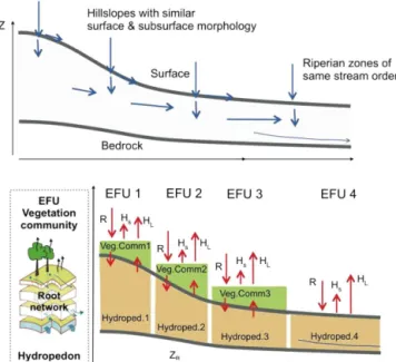
Figure 1.Catchment functioning reflecting context-dependent controls of different elementary functional units (EFUs) or lateral topological units (LTUs). Members of the same EFU class exert similar terrestrial controls on the surface energy balance (when in similar states and exposed to similar radiation/rainfall forcing). EFUs thus control functional similarity during radiation-driven conditions acting in parallel; class members could be ideally represented by the same parameter set related to the energy balance and vertical water flows. Members of the same LTU class exert similar terrestrial controls on rainfall runoff generation as the embedded EFUs are interlinked by lateral, gravity-driven water flows. Hillslope-scale LTUs control functional similarity; members of classes could be ideally represented by the same parameter set characterizing lateral flows and EFU-scale parameters.
land surface energy balance, (2) at the hillslope scale with re-spect to (∇8,R) controlling rainfall-runoff transformation,
and (3) at the headwater/subcatchment scale with respect to (∇8, R) controlling groundwater storage and release. As
a consequence, we propose the existence of three specific functional units (specialized HRUs) for a specific form of “water release”, which operate at the three different scales (Fig. 1):
– Field-scale elementary functional units (EFUs) of the same class are expected to function similarly with respect to the land surface energy balance and ET. They dominate catchment functioning during radiation-driven conditions, acting vertically and thus in parallel. Members of different EFU classes are characterized by similarity of the terrestrial properties controlling the ra-diation balance, the Bowen ratio, ET and root water up-take, and upward flows of capillary water in the soil ma-trix (Fig. 2, Table 2).
– Hillslope-scale lateral topological units (LTUs) of the same class are expected to function similarly with re-spect to runoff formation during rainfall-driven condi-tions. They release water during and after rainfall events
due to activated, topologically connected flow paths which dominate free water fluxes either at the surface, in subsurface lateral drainage networks, or at the bedrock interface or through fractures to the aquifer. Members of the same LTU class thus share the same dominant runoff mechanism, and consist of the same organized sequence of EFUs from the hill crest to the stream, which are likely interconnected by the same type of lateral (pref-erential) flow paths (Fig. 2, Table 2).
– Sub-catchment-scale hydro-geomorphic units (HGUs) of the same class function similarly with respect to groundwater storage and release. HGU classes are de-termined by the hydro-geological and geomorphic set-ting of subcatchments. This determines the starset-ting point for morphological processes, thereby constraining the set of hillslope forms, as well as parent rock for soil formation (Fig. 2, Table 2).
Figure 2. Scheme of lateral topological units and embedded el-ementary functional units controlling rainfall runoff response and land atmosphere energy exchange.
the atmosphere or as event runoff alongside the differ-ent driving gradidiffer-ents, differdiffer-ent associated preferdiffer-ential flow paths that get potentially activated, and different forms of water storage depletion. Before we further explain how the proposed hierarchy might facilitate a representative experimentalcharacterization of intermediate-scale catch-ments, it is necessary to reflect on equifinality (Beven and Freer, 2001) as an inherence of hydrological dynamics.
2.4 Equifinality as inherent in our governing equations and options for its reduction
Equation (1) is inherently subject to equifinality as several combinations of gradients and resistances yield the same flux (e.g., an increase in bedrock slope can be compensated by de-creasing subsurface hydraulic conductivity to yield the same flux). This might frequently be the case in hydrological sys-tems as the quasi-static controls on gradients driving lateral flows of free water during rainfall-runoff transformation are largely independent of those that determine the flow resis-tance. In line with Bardossy (2007) we suggest that the equi-finality in Eq. (1) can partly be reduced by collecting infor-mation that characterizes at least two of the three variables: either q (or a proxy thereof) and terrestrial controls on R,
orqand terrestrial controls on∇8, or terrestrial controls on
∇8andR. This option has clear implications for:
– A feasible experimental design to characterize intermediate-scale catchments, which should rely on characterizing the outlined pairs (if possible) in replicate members of candidate functional units along the proposed hierarchy;
– The structural adequacy of models, which should be thermodynamically consistent (as already called for by Reggiani et al., 1998) and thus able to disentangle the driving gradients and resistances controlling hydrologi-cal fluxes. This allows, for instance, constraining the set of feasible behavioral subsurface flow resistances by in-corporating available information on the corresponding gradients driving lateral flows (e.g., bedrock topogra-phy).
Current technology allows in principle the characteriza-tion of the terrestrial controls of all hydrologically relevant gradients, and even bedrock topography may be approxi-mated using geophysical imaging techniques. Fingerprints of lateral subsurface fluxes and resistances (including fin-gerprints of preferential flow paths) may be retrieved from natural and artificial tracers. Also ET patterns can be esti-mated by new remote sensing techniques coupled with high-resolution soil–vegetation–atmosphere transfer (SVAT) mod-eling. However, a combination of these techniques with soil physical methods, to characterize resistance terms, or sap flow to estimate local transpiration fluxes, is hampered by well-known scale issues and the high amount of labor, and is thus only feasible to a limited extent. We thus suggest clustering of these observations in replicate members of EFU or LTU classes, mainly to explore whether their main struc-tural and functional characteristics can indeed be character-ized in an exemplary manner. If this were true, it would im-ply that behavioral model parameters characterizing structure and functionality of EFUs or LTUs were indeed transferable among all members of the same class.
3 Implications for experimental characterization of intermediate-scale catchments
The idea of HRU or specific functional units implies that their typical dynamic behavior might be grasped by thor-oughly characterizing the structural setup and functionality of a subset of only a few members of each class. Up to now, a large set of HRU separation methods has been suggested, such as (an exhaustive review being beyond the scope of this paper):
– Topographic indicators to support geomorphology-based predictive mapping of soil thickness (Pelletier and Rasmussen, 2009), soil erosion processes (Märker et al., 2011), and other soil properties (Behrens et al., 2010), or
– Explanations of the variability of base flow response based on climatic, soil and land use characteristics (San-thi et al., 2008; Haberlandt et al., 2001), or even
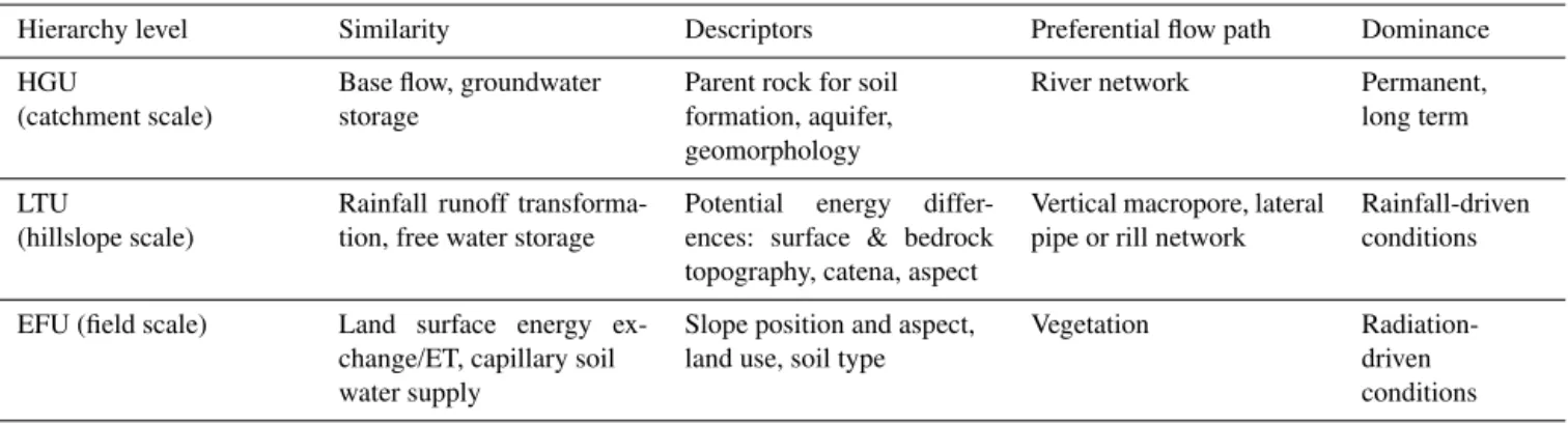
Table 2.Hierarchy of proposed functional classification scheme, controlled form of water release, candidate descriptors, dominant preferen-tial flow path, and hydrological context of dominance.
Hierarchy level Similarity Descriptors Preferential flow path Dominance
HGU
(catchment scale)
Base flow, groundwater storage
Parent rock for soil formation, aquifer, geomorphology
River network Permanent,
long term
LTU
(hillslope scale)
Rainfall runoff transforma-tion, free water storage
Potential energy differ-ences: surface & bedrock topography, catena, aspect
Vertical macropore, lateral pipe or rill network
Rainfall-driven conditions
EFU (field scale) Land surface energy ex-change/ET, capillary soil water supply
Slope position and aspect, land use, soil type
Vegetation
Radiation-driven conditions
small-scale experiments for agricultural land (Naef et al., 2002; Schmocker-Fackel et al., 2007).
A rigorous experimental test of whether HRUs exist in the landscape has, however, never been carried out. A major ob-stacle to implementing such an experimental test, or more precisely to searching for the proposed hierarchy of func-tional units, is to balance the need for exhaustive character-ization of the triple of (q,∇8,R) within class members of
functional units with the need to conduct replicate experi-ments and monitoring to detect typical functional and struc-tural characteristics among class members. The null hypothe-sis, for example for EFUs, is that their class members belong to the same ensemble with respect to the interplay of the en-ergy balance (including ET), root water uptake, and capil-lary soil water dynamics. This implies that mean and spatio-temporal variability of, for instance, sap flow, soil moisture, and surface and soil temperature dynamics observed within replicates should be identical within the confidence limits, and significantly differ from the corresponding observations obtained in members of other EFU classes. However, to en-sure an acceptable significance level of such a test of con-cept one cannot exclusively rely on observations, because the sample sizes, N, within EFU class members are likely
to be small (and the confidence limits of the mean decrease with N−1/2). This exercise must thus be essentially
com-bined with a test of whether behavioral model parametersets
are transferable among class members of functional units at the same hierarchy level.
3.1 How to characterize EFUs and their structure and functionality?
3.1.1 Controls and characteristics of EFUs
We hypothesize that similarity with respect to the surface energy balance and ET emerges at the EFU/field scale (1000 m2) due to emerging homogeneity with respect to the terrestrial controls on the radiation balance, root water up-take and capillary water storage/upward capillary rise. This
is because the covariance lengths of the governing soil hy-draulic parameters, soil moisture, and controlling vegetation are in the order of 1–10 m (Zimmermann et al., 2008; Zehe et al., 2010b; Gerrits et al., 2007). We further suggest that lateral variability of soil water potential at a given depth is during energy-driven conditions rather small at this scale. This is supported by the observed stability of ranks and abso-lute mean differences among 80 soil moisture sensors Zehe et al. (2010b) clustered at a forested and grassland site. The reported persistence of these differences at a scale extent of 10 by 10 m might reflect small-scale heterogeneity of soil texture, but not necessarily differences in driving potentials. This is because the persistence of differences can be ex-plained by absence of lateral soil water flows, which in turn may be due to absence of a lateral gradient in soil water po-tential. The latter implies that a vertical 1-D treatment of soil water flow (as proposed in Sect. 4.2) is still appropriate at this scale.
Our first guess predictors for detecting candidate EFUs in a given geological setting are thus land use and manage-ment practice, location within the catena, and hillslope as-pect (Fig. 2, Table 2). These factors determine exposure to global radiation, surface albedo, and either the age spectrum and species composition of trees in forest areas or surface preparation and selection of crops in agricultural areas (with a certain plant albedo).
3.1.2 Characterization of the energy balance and gradients and resistances at the EFU-scale For EFU detection and characterization we propose com-bined observations of global radiation and the albedo (∇8),
sap flow (relates toq) within trees species of representative
age stages, air temperature and humidity (relate to∇8)
the soil water retention curve driving upward capillary water flow (relates to∇8). We propose a combination of in situ
ob-servations of soil moisture and matric potentials in the field (for inverse modeling and soil landscape modeling), perme-ameter measurements and undisturbed soil cores to be ana-lyzed in the lab. Comparison of inverted hydraulic parameter sets with those derived from soil samples quantifies the ef-fect of activated preferential flow paths, as the former jointly represent flow in both domains (Troch et al., 1993; Hopp and McDonnell, 2011).
As some networks of preferential flow paths are created by biota such as earthworms, ants, and rodents (Lavelle et al., 2006; Meysman et al., 2006), an ecological survey of the abundance and number of individuals of soil ecosystem en-gineers creating vertical and lateral preferential flow paths might yield helpful proxy information on density and depth of biotic macropores.
3.2 How to identify LTUs and characterize their struc-ture and functionality?
3.2.1 Controls and characteristics of LTUs?
Class members of hillslope-scale LTUs are deemed to be-long to the same ensemble with respect to controls of rainfall runoff behavior (note that we exclude homogeneity with re-spect to base flow production here). We propose that homo-geneity with respect to the terrestrial controls on rainfall in-terception and the gradients driving vertical and lateral fluxes of free water emerges at this scale. This is because hillslopes are key elements organizing rainfall-runoff transformation in many intermediate-scale catchments (e.g., Troch et al., 2004; Berne et al., 2005), connecting areas of maximum potential energy located at the watershed boundary to local minima in potential energy located at the stream, which the latter mark-ing a local minimum in potential energy. Hillslopes are al-ready large enough to be distinguished based on typical spa-tial patterns characterizing their flow path morphology (con-fluent, parallel, divergent), their hydro-pedology based on the soil catena (Milne, 1936) and permeability of the parent rock including dip direction and slope of facies and optionally fractures.
Then again, hillslopes are smaller than the length scales of meso-scale and even of most micro-scale atmospheric struc-tures (including convective rainfall cells); spatial variabil-ity of the atmospheric forcing within the hillslope is thus controlled by slope topography, aspect, and land use. The fact that rainfall runoff in different hydro-climates may be successfully simulated using model structures that rely on several typical hillslopes as building blocks (Güntner, 2002; Zehe et al., 2005, 2013; Jackisch et al., 2014) is another strong argument that homogeneity with respect to rainfall-runoff transformation emerges at the hillslope scale.
We propose that within a given hydro-geological and ge-omorphic setting, a similar surface and bedrock topography
and morphology alongside a similar land use are first-order determinants for LTU classes (Fig. 2, Table 2). These fac-tors determine the ensemble for interception and infiltration, as well as the steepness of the water level/potential energy gradient that might drive lateral flows and the conditions for sediment redistribution and formation of the soil catena.
3.2.2 Characterization of rainfall-runoff transforma-tion, gradients and resistances at the LTU scale As neither flow at the bedrock interface nor in lateral pipe networks is directly observable, we still struggle to under-stand how, when and why hillslopes connect to the stream. In recent years promising new investigation techniques have been proposed to add bits and pieces to this puzzle; for in-stance, distributed temperature surveys (DTSs) of groundwa-ter inflow locations along streams (e.g., Selker et al., 2006; Westhoff et al., 2007) or thermal infrared imagery of satu-rated area dynamics (e.g., Pfister et al., 2010; Schuetz and Weiler, 2011). Source areas of runoff onset and cessation in the hillslope, riparian zone, stream continuum might be characterized using biological tracers (Pfister et al., 2009), occasionally with radon as a tracer of groundwater input and extensive observation networks (e.g., Jencso et al., 2010; Tromp van Meerveld and McDonnell, 2006).
Bedrock topography, as key control on gradients driving lateral flow, may be furthermore approximately characterized by geophysical imaging techniques such as electric resistiv-ity tomography (ERT, e.g., Graeff et al., 2009) or ground penetrating radar (GPR). These techniques are, however, la-borious and need to be validated with auger profiles, because even joint geophysical inversions can be non-unique (e.g., Binley et al., 2002; Paasche and Tronicke, 2007). Time-lapse GPR using a shielded antenna is furthermore promising for in situ observation of shallow subsurface hydrological pro-cesses. Up to now such surface-based techniques are rarely used for monitoring purposes. Because of the high demands on data quality only a handful of successful examples is re-ported, which are mainly carried out in controlled environ-ments such as sand boxes (e.g., Versteeg and Birken, 2001; Trinks et al., 2001; Truss et al., 2007; Haarder et al., 2011).
3.3 How to identify HGUs and to characterize their structure and functioning?
3.3.1 Controls and characteristics of HGUs
homogeneous geology, climate conditions and land use. As this rarely is the case in intermediate-scale catchments, there is a need to understand how homogeneous geologies and land uses as well as different mixtures thereof control groundwa-ter storage and release.
3.3.2 Characterization of free water storage and release across scales and geologies
The majority of the related tracer-based investigations have been carried out in small, geologically homogenous, ex-perimental catchments (Klaus and McDonnell, 2013). More recent work has begun to explore tracer signatures across scales, ranging from hillslopes to headwaters (e.g., Uchida et al., 2005; McGuire and McDonnell, 2006) to lower meso-scale (∼200 km2)catchments. McGuire et al. (2007) showed for the Western Cascades in Oregon that mean transit time (MTT) was positively correlated to flow path length and neg-atively correlated to flow path gradient. Additionally Hra-chowitz et al. (2009) reported for a set of 20 headwater catch-ments (1 to 35 km2)that MTT is strongly controlled by pre-cipitation intensity and soil cover, drainage density and topo-graphic wetness index. While geological factors have been omnipresent in MTT scaling studies, few investigations have been able to identify distinct geological differences across nested and neighboring catchments (e.g., Sayama et al., 2011). However, studies available today (e.g., Maloszewski et al., 1992; Dewalle et al., 1997; Viville et al., 2006; Tet-zlaff et al., 2006, 2009; Heidbüchel et al., 2013) do not yet span a wide enough range of bedrock types where both flow and isotope tracer data are available to draw more gen-eral conclusions on how catchment bedrock conditions influ-ence mixing, storage, and release across scales. Such studies should furthermore be completed by a characterization of the space/time variability of climate and land-use controls.
4 Implications for structurally adequate modeling 4.1 Reduce inherent equifinality by removing physical
and structural biases
4.1.1 Thermodynamically consistent model equations We already proposed that structurally adequate models for intermediate-scale catchments should be thermodynamically consistent to draw advantage from the structure of Eq. (1) by including available data on a pair out of the triple of flux, gradient, resistance (q,∇8,R). This allows constraining of
the set of feasible behavioral subsurface flow resistances by incorporating available information on bedrock topography at the hillslope scale, as well as soil water retention prop-erties and proxies for macroporosity along the catena. As an exhaustive observation of these characteristics at the interme-diate scale is out of reach, this option is feasible only if the structure and functionality of functional units may indeed be
exemplarily characterized and the related behavioral, struc-tural, and functional parameter sets are indeed transferable among members of the same EFU or LTU class.
Most conceptual models are not thermodynamically con-sistent because they merge driving gradients and resistances into effective descriptions (Westhoff and Zehe, 2013). Dis-tributed physically based models employ thermodynamically consistent model equations; commonly the Darcy–Richards approach, the convection dispersion approach, and ap-proximations of the Saint-Venant equations. In principle, they allow consistent predictions of internal dynamics and input–output behavior, including non-Gaussian transport, based on different conceptualizations of preferential flow up to the headwater scale, as recently shown by, for example, Gassman et al. (2013). Nevertheless, a full 3-D physically based model might not be a “perfect model” for intermediate-scale catchments, either when defining perfection on the ba-sis of a balance of complexity and parsimony or with re-spect to straightforward accessibility of structural model er-rors (Reusser et al., 2011; Reusser and Zehe, 2011).
4.1.2 Disentangling matrix fluxes and rapid fluxes in connected networks
Model structural adequacy also requires, in our opinion, sep-arate treatment of fluxes in matrix/continuum elements and connected network-like structures. This should be addressed for vegetation controlling transpiration, for flow in the river network, and in particular for subsurface vertical and lateral preferential flows, for several good reasons. First, because matrix flow and preferential flow sustain different forms of water release, they are dominated by different forces (either capillary forces or gravity) and deplete different gradients in free energy, as explained above. Second, with the soil ma-trix and preferential flow paths acting as independent factors that control subsurface flow resistances, they are indepen-dent sources of equifinality (e.g., Binley and Beven, 2003; Wienhöfer and Zehe, 2014). Preferential flow networks with different topological and hydraulic properties may result in the same control volume resistance and thus match observed flow and transport equally well, even if all other model pa-rameters are kept constant (Wienhöfer and Zehe, 2014). Sep-arate treatment of matrix flow as well as vertical and lat-eral preferential flow allows constraining of the degrees of freedom in both flow domains independently, using different appropriate sources of information and genetic knowledge about the differences in their origin.
This approach preserves the flow path topology (Wienhöfer and Zehe, 2014) and may be parameterized based on ob-servable field data or on estimates from species distribution models for ecosystem engineers (Schröder, 2008; Schnei-der and SchröSchnei-der, 2002). Such an explicit approach further-more allows testing of thermodynamic optimality principles, which allow for a priori optimization of the resistance field at a given gradient (Porada et al., 2011). This implies the possibility of independent predictions based on optimized model structures and preferential flow networks (compare to Sect. 4.3).
4.2 What is a perfect (and yet thermodynamically con-sistent) model?
“Perfection is achieved, not when there is nothing more to add, but when there is nothing left to be taken away”. In line with thisbon motof Antoine de Saint-Exupéry, we regard a
model as perfect if it balances necessary complexity with the greatest possible parsimony. Although thermodynamic con-sistency of equations and separate treatment of matrix and preferential flow are not negotiable, we think that simplicity can be achieved for instance by stating clear hypotheses on (a) how spatial organization creates anisotropy in dominant terrestrial water and energy flows (thereby reducing dimen-sionality of the governing equation set), or (b) how to account for preferential flow paths and how to couple fast and slow flow domains, or (c) how to conceptualize driving gradients in a smart and unbiased manner.
4.2.1 Pioneering research and models to balance neces-sary complexity with parsimony
The Representative Elementary Watershed (REW) approach proposed by Reggiani et al. (1998) is certainly pioneering in proposing a simplified but thermodynamically consistent treatment of the mass, energy, and momentum balance of hy-drologically homogeneous control volumes (named REWs). Reggiani et al. (1998, 1999) derived the set of balance equa-tions for the REW and subcontrol volumes/process domains (e.g., the unsaturated and saturated flow domains, character-istic areas where either Hortonian or Dunne’s overland flow dominate) using thermodynamic consistent averaging (Reg-giani et al., 1998, 1999; Reg(Reg-giani and Schellekens, 2003; Reggiani and Rientjes, 2005). The related parameters and state variables are, thus, to be regarded as effective represen-tations of point scale state variables and parameters (Zehe et al., 2006; Lee et al., 2007; Mou et al., 2008). Beven (2006) identified the assessment of suitable closure relations to char-acterize exchange flows of mass, energy, and momentum as the cardinal problem when applying the REW approach to real catchments. And there has been considerable progress in this respect: REWASH developed by Reggiani and Rien-tjes (2005) has been successfully applied to the Geer catch-ment in Belgium and to the Donga basin in Benin by Varado
et al. (2006). Zhang et al. (2006) introduced a macropore flow domain into the REWASH model, which considerably im-proved its performance when applied to the Attert basin. In particular they were able to simultaneously reproduce stream flow and distributed observations of groundwater.
However, all the listed applications of the REW approach up to now treat sub catchments and REWs as synonymous and flow within the control volumes in a spatially averaged zero-dimensional manner. This is problematic as it implies averaging across different ensembles – for instance soil types – and with respect to the local equilibrium assumption. Fur-thermore, it is exactly the deviation from the spatial average compared to the uniform distribution what makes up spa-tial organization. Thus, the REW approach is in our opin-ion over-simplified with respect to how it represents different forms of hillslope scale spatial organization and thus eventu-ally with respect to how it reduces equifinality in the manner specified above.
The hillslope storage Boussinesq (HSB) model proposed by Troch et al. (2004) is another pioneering work, based on an analytical solution of the linearized Boussinesq equa-tion that describes discharge from a free unconfined aquifer that develops over impermeable bedrock. The HSB model is tailored for hilly landscapes with shallow, permeable, weakly heterogeneous soils, where subsurface storm flow and saturated excess overland flow dominate runoff gener-ation (Hilberts et al., 2004, 2005; Troch et al., 2004; Berne et al., 2005). Although treatment of hillslope scale spatial vari-ability of infiltration is a challenge, this concept is valuable in the sense that rainfall-runoff transformation is dominated by lateral fluxes of free non-capillary water and a simplified but unbiased treatment of this process.
of land-surface energy exchange and capillarity-dominated flow during radiation-driven conditions. However, it would be unfair only to blame TOPMODEL as being too simple in terms of predictions of land-surface energy exchange: most hydrological and land-surface models produce severe errors in this respect, especially with respect to the influence of veg-etation. Another error source is shallow turbulence param-eterization, which is in most atmospheric based models on Monin–Obukhov similarity and related stability functions. The underlying key assumptions – horizontal homogeneity and constant turbulent fluxes near the ground – are, however, questionable at intermediate scales, especially in the case of a rugged topography.
4.2.2 Suggestion of a simple but structurally adequate modeling framework: the CAOS model
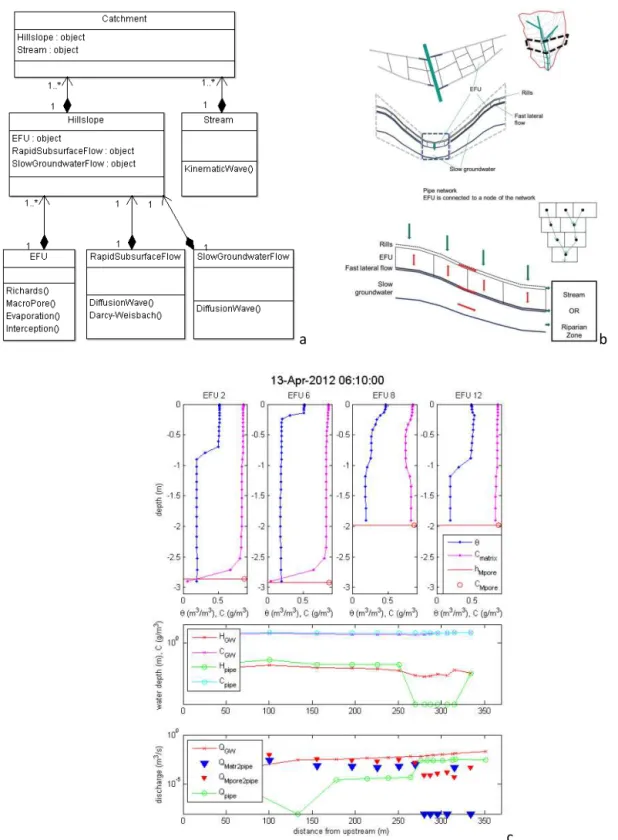
The CAOS (Catchment as Organized Systems) model sim-ulates water, tracer, and heat dynamics based on thermody-namically consistent equations and disentangles matrix and preferential flow. Our proposition to achieve parsimony is to represent only the dominant matrix and preferential flow processes at the EFU, hillslope, and catchment levels in a coupled but 1-D manner. We further propose that flow in network-like structures dominates over matrix flow during rainfall-driven conditions. The CAOS model consists of hi-erarchical objects (Fig. 3) with the catchment object on top, followed by hillslope and riparian zone objects. The least model entities are not REWs but EFUs, which control verti-cal flows of land-surface energy exchange and ET (based on the Penman–Monteith approach) and related vertical flows of upward capillary rise and soil heat during radiation-driven conditions or downward gravity-driven preferential flow dur-ing rainfall-driven conditions. Durdur-ing radiation-driven condi-tions we use the Darcy–Richards equation, which, although often criticized, is still the best concept to describe capillary-driven water flows. Flow in the macropore domain dur-ing rainfall-driven conditions is represented either through a kinematic wave equation or via a stochastic approach. As motivated by Davies and Beven (2012), the latter consists in treating water flows during rainfall-driven conditions by means of a space–time domain random walk of water par-ticles. Diffusive model parameters may be estimated based on soil water characteristics, while the probability density function of advective flow velocities in preferential pathways is retrieved from tracer travel depth or travel time distribu-tions. Related macropore densities and depth may be esti-mated from dye staining, time lapse GPR, or data on the abundance of ecosystem engineers. Water beyond saturation is directed to either the macropore domain or the Rapid Sub-surface Flow object, which laterally connects EFUs along the downslope driving gradient. The lower boundary condition is free drainage which connects to the Slow Groundwater Flow object.
Lateral exchange between EFU objects during rainfall runoff is treated in separate hillslope-scale network do-mains representing either overland flow in rills or subsur-face lateral flow. Flow within these networks is modeled with the diffusion wave or the Darcy–Weisbach equation re-spectively. Motivated by the experimental findings of van Schaik et al. (2008), van Schaik (2009) and by unpub-lished experimental findings of an irrigation experiment out-lined in Sect. 5.1.1, we neglect exfiltration from the lateral flow domains into the surrounding matrix/EFU objects. The slow groundwater domains account for base flow production through a diffusion wave equation. It receives its water from the lower boundary of the matrix domain and the rapid sub-surface flow object. Groundwater flow on the hillslope is as-sumed to be homogeneous perpendicular to the line of steep-est descent. The stream domain is also represented as a net-work. It receives its water from the Rapid Subsurface Flow and Slow Groundwater Flow objects of all connected hill-slopes. Flow is described with the kinematic wave equation. Each of the model objects has a transport module based on the advection–dispersion equation, including a decay term to account for the transport of solutes, isotopes or thermal en-ergy. Adaptive time stepping and the same explicit/implicit Crank–Nicolson scheme as in the water flow solvers are used. An example of the overall model output is given in Fig. 3. The restriction to multi-1-D representations and of the EFU size to be approximately 1000 m2and applying the “θ-based”
version of the Richards equation reduces the computation time significantly. With respect to model complexity, the CAOS model concept is on the one hand steps beyond the REW concept (Reggiani et al., 2005; Lee et al., 2007) as it avoids averaging across landscape components of differ-ent function and hence allows closure of the mass, momen-tum, and energy balance in a spatially resolved manner. On the other hand, the model is clearly simpler than fully dis-tributed, physically based models such as HydroGeoSphere, HYDRUS 3D and CATFLOW.
4.3 Thermodynamic consistency to test thermodynamic optimality
4.3.1 Organizing principles – a possible link between catchment structure and functioning
a b
c
Figure 3. (a)Simplified UML diagram of the current CAOS model structure. Each object either has child objects or solves 1-D flux equations. (b)Sketch of the physical model elements.(c)Exemplary visualization of model states and output: top panels show EFU soil moisture profiles and tracer concentrations, middle panel shows water levels and tracer concentration in fast and slow lateral flow domains, lower panel shows discharge from soil matrix and macropores into pipes as well as along the lateral flow domains. Numerical solutions have mass relative balance errors of order 0.001 to 0.01.
local energy dissipation, and based on this they reproduced observed fractal characteristics of river networks.
Related to these energetic minimization principles, the lit-erature debates several principles that seem to state exactly the opposite (Paik and Kumar, 2010): that systems orga-nize themselves to maximize steady state power (MAXP proposed by Lotka (1922)), steady state net reduction of free energy (MRE – Zehe et al., 2010, 2013), or steady state max-imized entropy production (MEP – Paltridge, 1979) asso-ciated with environmental flows. The MEP hypothesis has been corroborated within studies that allowed (a) success-ful predictions of states of planetary atmospheres (Lorenz et al., 2001), (b) identification of parameters of general circu-lation models (Kleidon et al., 2006), or (c) identification of hydrological model parameters to estimate the annual wa-ter balances of the 35 largest basins on earth (Porada et al., 2011). Kleidon et al. (2013) recently explored whether the formation of connected river networks is in accordance with MAXP and thus whether “free” energy transfer to sediment flows is maximized. What they showed is that the depletion of topographic gradients by sediment transport is linked to a minimization in frictional dissipation in streamflow, so that maximization and minimization approaches may not neces-sarily contradict each other.
We thus suggest that these outlined maximization and min-imization principles are largely two sides of the same coin, because local minimization of frictional dissipation of kinetic energy increases the flow’s ability to transport matter against the driving macroscale gradient and thus to deplete it.
4.3.2 Promising findings and the need for stronger tests These outlined organizing principles allow for a priori opti-mization of the resistance field at a given gradient (Porada et al., 2011) with respect to an objective function. This im-plies the possibility of independent predictions either using an optimized bulk resistance (Westhoff et al., 2014) or based on an optimized density of vertical and lateral macropores (Zehe et al., 2013; Kleidon et al., 2013). If conclusive, this might be seen as an argument that at least the potential nat-ural state of a catchment as open terrestrial system functions in accordance with such a principle.
Zehe et al. (2013) provided evidence that the spatially or-ganized pattern of soils and macropores in the Weiherbach, reflecting past erosion processes (Zehe and Blöschl, 2004) and habitat preference of anecic earthworms (van Schaik et al., 2014), is superior to other tested arrangements with re-spect to long-term reduction of free energy of soil water. This implies that the true system configuration operates closer to local thermodynamic equilibrium (LTE) than the other con-figurations. They showed furthermore that an uncalibrated 1.5-year simulation of rainfall-runoff transformation based on an apparent thermodynamic optimum in the surface den-sity of macropores, which maximized free energy reduction during rainfall runoff processes (thereby minimizing system
time to recover back to LTE), performed as well as the best model setup calibrated based on rainfall runoff data. It seems that in this old agricultural landscape, the slow co-evolution of landforms, soil catena formed by erosion, and macrop-ore patterns to a system architecture far from thermodynamic equilibrium implies that the system dynamics, however, op-erates close to local thermodynamic equilibrium, except for a few extreme events.
The same study by Zehe et al. (2013) revealed that the rel-atively young landscape in Malalcahuello catchment in the Chilean Andes, close to the Volcano Longymay, operates close to a steady state in the potential energy of soil water. A model structure assuming that gains in potential energy due to infiltration into these highly permeable volcanic ash soils are in the long term compensated by potential energy export by means of subsurface storm flow allowed an uncal-ibrated prediction of rainfall runoff within an Nash Sutcliffe efficiency (NSE) of 0.65. Finally, a parsimonious model for the land-surface energy exchange based on maximum power and Carnot efficiency by Kleidon and Renner (2013a, b) per-formed well, without calibration, against flux tower data at three sites with different land use and at the global scale against ERA 40 reanalysis data. This implies that turbulence in the convective boundary layer, which forms at a timescale of 10–20 min, is structured such that sensible heat fluxes op-erate close to the upper limit determined by Carnot efficiency. We conclude that a thermodynamic perspective is very helpful for explaining the operative advantage of organized preferential flow structures: push it to the limit and mini-mum time for recovery. In case structures establish fast com-pared to characteristic time of mass and energy flows as in the boundary layer, they push the system to operate at its (Carnot) limit. In case organized structures result from a very slow co-evolution, as in the Weiherbach, they minimize time of the system to recover back to LTE. However, we acknowl-edge that (a) the validity and the practical value of thermo-dynamic optimality are still debated (see also discussion of this paper in HESSD) and (b) that the reported promising findings might be just a matter of coincidence. A test of con-cept based on successful uncalibrated predictions relies im-plicitly on the assumption that the model is “closed”, i.e., is an acceptable representation of the system accounting for all relevant degrees of freedom and of the feedbacks between processes that form structures and their impact on water and energy flows. As none of the reported model studies is closed in this sense, there is a strong need to define rigorous model and real world experiments to test how far thermodynamic optimality applies.
5 Conclusions and outlook
has been driving joint research within the CAOS project for the last 2.5 years. Key objectives of the CAOS project are to test our three main propositions: on (a) a scale hierar-chy of functional units and a strategy for their characteri-zation, (b) requirements to be met by structurally adequate models, and (c) the search for organizing principles linking catchment structure and functioning. The area of focus is the Attert hydrological observatory basin in Luxembourg, which has been operated in since 1994 by the CRP–Gabriel Lippmann (e.g., Pfister et al., 2009, 2010; Martínez-Carreras et al., 2012). It consists of nine nested subcatchments that have homogeneous and mixed geologies ranging from schists to marl, sandstone and limestone, different land uses and a semi-oceanic climate.
5.1 Brief outlook on the ongoing proof of concept 5.1.1 Experimental design
In line with the hypotheses and ideas proposed in Sect. 3 for an experimental test of the HRU concept, 46 candidate EFUs in two candidate LTUs have been instrumented since 2011 with automated sensor clusters (SCs). A single SC col-lects data on rainfall (N=5), air temperature, relative hu-midity, and wind speed, global radiation; soil moisture pro-files (N=10), electric conductivity (N=10), and soil tem-perature (N=10); matric potential (N=10), water levels (N =4) to observe groundwater and stream water levels, and five sap flow (N=4). 23 sensor clusters are located within candidate EFUs in the schist area, of which 6 are along north facing slopes and 10 along south facing slopes, 7 units are situated close to a stream, and we included 16 forest and 7 pasture sites. Within the sandstone and marl areas 12 and 11 EFUs have been instrumented, respectively. This has been combined with an ecological survey of soil ecosystem engi-neers in combination with bromide profiles and dye staining. We sampled different earthworm species (in total 18 were found in the Attert catchment) and small rodents in a ran-domly stratified design at 117 locations (including the sensor cluster sites if possible), considering the gradients of differ-ent habitat factors covering the differ-entire catchmdiffer-ent. These data may serve as the basis for models predicting the spatiotempo-ral distribution of these species (Palm et al., 2013) and yield proxy information about preferential flow paths. To inves-tigate the relevant subsurface structures and properties we have evaluated different geophysical techniques. The com-bination of ERT, GPR, and a few manual auger profiles has proved to provide important information on depth to bedrock and the depth of the weathered schist layer, and can be used to evaluate the consistency of the first-guess lead topologies and to estimate the downslope extent of EFUs within selected LTUs.
At the hillslope/LTU scale connectivity between hill-slopes/riparian zones and streams has been characterized in detail for a tributary of the Colpach River in the Schist area
of the Attert catchment. Within 50 m reaches we measured incremental discharge, including radon as a natural tracer to distinguish between young water and old water draining from the hillslopes into the streams. Additionally salt tracer exper-iments were performed to derive gains and losses for several headwater streams during different flow conditions. This was completed with hand-held Thermal infrared (TIR) and DTS temperature observations of the streams to identify localized inflow locations. At the event timescale we conducted a hills-lope scale sprinkling experiment to explore the role of lateral subsurface flow in the near surface weathered schist layer and the feasibility of combining time lapsing GPR, time domain reflectometry (TDR) soil moisture profiling, and stable iso-tope profiling before and after the irrigation to jointly moni-tor subsurface flow processes within the upper 2–3 m.
The Attert observatory is also well suited to explore how homogeneous geologies and land use as well as different mixtures thereof control groundwater storage and release, as it provides natural tracer and rainfall runoff data for at least a decade for nine nested subcatchments (e.g., Pfister et al., 2002). Recent investigations focus on geological controls on isotopic signatures in baseflow and catchment dynamic stor-age (as per Sayama et al., 2011) and the spatial and tem-poral variance of storage capacities and dynamics, as well as of contributions from saturated and unsaturated zones. To this end we rely on the complementarities of multiple tracers (geochemicals, stable isotopes of O and H, tritium), hydro-metric data and in situ observations and remote sensing of soil moisture.
Spatio-temporal variability of precipitation is of key im-portance for discriminating functional similarity and dissimi-larity. It is characterized by merging operational rainfall radar data with rain gauge data as well as disdrometer data to characterize droplet sizes and vertical rain radar that have been installed within the Attert catchment at three meteo-sites. These data are combined: (a) by means of data assim-ilation into the soil–vegetation–atmosphere model system WRF-NOAH-MP (Skamarock et al., 2008; Schwitalla and Wulfmeyer, 2014) and (b) by a geo-statistical merging orig-inally proposed by Ehret et al. (2008) for improving quan-titative precipitation estimates. During radiation-driven con-ditions horizontally averaged sensible and latent heat fluxes are observed by means of a scintillometer and airborne ther-mal remote sensing that yields spatially highly resolved data on leaf temperature and soil surface temperature at different time slices. Spatial patterns of land cover and leaf area in-dex are derived from Landsat and Modis satellite images to support EFU identification by means of pattern recognition.
5.1.2 Spatial transferability of parameters as genuine test of model structural adequacy
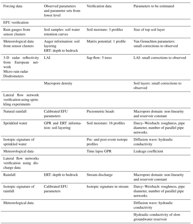
Table 3.Available observations and calibration parameters for CAOS model verification at different scale levels.
Forcing data Observed parameters and parameter sets from lower level
Verification data Parameters to be estimated
EFU verification
Rain gauges from sensor clusters
Soil samples: soil water retention curves
Soil moisture: 3 profiles Size of top soil layer
Meteorological data from sensor clusters
Auger information: soil layering
ERT: depth to bedrock
Matrix potential: 1 profile Van Genuchten parameters: small corrections to observed
3-D radar reflectivity from European net-work
Micro rain radar Disdrometers
LAI Sap flow: 5 trees LAI: small corrections to observed
Macropore density Soil layers: small corrections to observed
Lateral flow network verification using sprin-kling experiments
Natural rainfall Calibrated EFU parameters
Piezometric heads Macropore domain: non-linearity and reservoir constant
Sprinkled water GPR and ERT informa-tion: soil layering
Soil moisture: 16 profiles Darcy–Weisbach: roughness, pipe diameter, number of parallel pipe networks
Isotopic signature of sprinkled water
Pre- and post-event isotope profiles
Diffusion wave: hydraulic conductivity
Meteorological data Time lapse GPR Leakage coefficient
Lateral flow networks verification using dis-charge data
Rainfall ERT: depth to bedrock Stream discharge Macropore domain: non-linearity and reservoir constant
Isotopic signature of rainfall
Calibrated EFU parameters
Isotopic signature in stream Darcy–Weisbach: roughness, pipe diameter, number of parallel pipe networks
Meteorological data Diffusion wave: hydraulic
conductivity
Hydraulic conductivity of slow groundwater reservoir
units does exist and whether their thorough exemplary ex-perimental structural and functional characterization is help-ful to partly reduce inherent equifinality. The ongoing hi-erarchical verification approach spans from the EFU scale across hillslope and headwater scales (Table 3). In addition to the traditional split sampling tests (calibration/validation periods), the verification approach therefore also comprises parameter transfer tests among EFUs of the same class and hillslopes of the same LTU class. As this verification is a mul-tidisciplinary task, we also put a focus on the identification
and development of universally applicable verification crite-ria and metrics. The major challenge here is to find ways for joint evaluation across variables and scales and to complete established metrics tailored for specific observables.