ECLAS Conference 2017 / Proceedings Creation/Reaction/
University of Greenwich
Department of Architecture & Landscape London UK
University of Greenwich
Department of Architecture and Landscape 11 Stockwell Street
Greenwich London SE10 9BD First published in 2017
Copyright © University of Greenwich All rights reserved
No part of this publication may be reproduced in any form or by any means, electronic or mechanical, including photography, recording or any information storage and retrieval system without permission in writing from the publisher Every scientific paper published in these Conference Proceedings was peer reviewed. All explanations, data, results, etc. contained in this book have been made by authors to their best knowledge and were true and accurate at the time of publication. However, some errors could not be excluded, so neither the publisher, the editors, nor the authors can accept any legal responsibility or liability for any errors and omissions that may be made.
ISBN 978-0-9935909-6-2
A digital version of this book is available for download at https://eclas2017london.com
Editors:
Duncan Goodwin, Benz Kotzen, Ed Wall & Tim Waterman
Design:
Mike Aling
Production:
Vanessa Celosse
Francesca Clementina Immirzi AnnaLaura Simeoni Ed Wall
115 9 . E CL A S Conf er enc e 201 7 . P ro ce edings Abstract
The growth of contemporary cities has been accompanied by the appearance of forgotten and abandoned spaces, as well as derelict structures that are part of a broad category of neglected and unoccupied spaces within cities. This situation which arises for economic reasons, property speculation, and the consequent expansion of the suburbs has become an important topic subject, as can be seen from the international bibliographical review about the “reuse” of vacant land and derelict structures in cities.
Traditionally urban planning dealt with growth which was the centre of attention. Modern urban planning arose in the 19th century associated with the need to find suitable housing for a growing urban population, and it retained this function over almost the entire 20th century. Although during that period there were some amounts of ruins that urban planners had to cope with, such destruction was occasional and scattered, linked to cataclysms or other exceptional circumstances.
In the final quarter of the 20th century urban planners were faced with situations that had been unknown in the lives of cities. Suddenly they found that not only the central areas of agglomerations but also entire urban regions were losing residents and businesses instead of growing.
These “perforated/random” abandoned or vacant spaces are a potential challenge when it comes to assigning them new “functions”. Most of these spaces house ecological formations. Some are the remnants of gardens or derelict green structures that survive over time and very often also perform a social role, but usually underperforming.
This study seeks to raise awareness of the aesthetic, functional and ecological qualities that these abandoned spaces can bring to a city and discuss ways of integrating them into the urban landscape that go beyond the conventional urban restoration models but rather represent alternative intervention solutions that may be applied permanently or temporarily. The refurbishing or reorganising of these spaces
Vacant land in
city: potential
functional,
ecological and
aesthetic role
in the urban
landscape
Ana Luísa Soares
University of Lisbon
Sónia Talhé Azambuja
University of Lisbon, University of Algarve
Eduardo Brito-Henriques University of Lisbon
Ana Rita Simões
University of Lisbon
Keywords:
naturalism, urban restoration, vacant land, Lisbon and Barreiro
1160 . E CL A S Conf er enc e 201 7 . P ro ce edings
will strength the urban ecological structure in addition to green spaces and so contribute to the promotion and preservation of biodiversity, urban resilience and risk mitigation.
The study presented here is part of NoVOID Project – “Ruins and vacant lands in the
Portuguese cities: exploring hidden life in urban derelicts and alternative planning proposals for the perforated city”, funded by the FCT and which is based on the identifying and classifying of the main vacant and derelict urban spaces (ruined buildings and public places vacant plots and abandoned or suspended projects) and assigning them an occupation in line with the new trends and sensitivities of architecture, landscape architecture and other specialist fields. The project, based on genuine situations in Portuguese cities Lisbon and Barreiro, seeks to contribute to sustainable urban and landscape proposals, of a permanent or temporary nature, that enhance their potential functional, ecological and aesthetic role and, in some cases, be an alternative to the conventional models of urban landscape restoration.
Introduction
The growing number of abandoned, neglected and unoccupied urban spaces, marks a new era of cities where the urban landscape has become “perforated” by ruins and vacant properties. These areas are widespread in the urban
landscape, from the centre to the periphery. Their intermittent and ubiquitous presence calls for a moment of criticism and provides an opportunity for creativity.
There have been many terms used to describe this kind of landscape. Sometimes, the images conveyed by some of these terms evoke
the abandonment, the disinvestment or the uncertainty, and marginality: “disabitato”, “wasteland”, “derelict land”, “drosscape”; “brownfield”, “nameless place”, “space of uncertainty”, “marginalia”, “interstices”, “in-between spaces”, or even “void”… The link to imperfection and incompleteness explains why to the solution has been to contradict
1161 . E CL A S Conf er enc e 201 7 . P ro ce edings
these expressions and transform them through major investments in urban regeneration and refurbishing operations.
Such places bring to mind the paradoxical ideas of absence and possibilities. An ambiguity that appears to have found agreement in the French term terrain vague, adopted by Ignasi de Solà-Morales to refer to city interstices, “its negative image, as much a critique as a possible alternative” [1]. Indeed, terrain vague summarises
the complex phenomena of abandoned places in less strict and more holistic terms, accepting the triviality of the landscape and treating the “vague” in definition to be of aesthetic value. Gilles
Clément goes further with his Manifeste du tiers
paysage [2], when he praises the ecological value
of such spaces, abandoned by Man but delivered to Nature. His work opened doors to a new way of understanding the functional, ecological and aesthetic value of these places.
In the context of the NoVOID Project – “Ruins and vacant lands in Portuguese cities: exploring hidden life in urban derelicts and alternative planning proposals for the perforated city”, funded by the FCT, we will present the
quantification by defined categories: ruin, ruin and yard and vacant land, to the cities of Lisbon and Barreiro, in order to future landscape
architecture proposals.
Terrain Vague and the History of Contemporary
Landscape Architecture
Both the American Revolution (1776) and the French Revolution (1789) paved the way for increasing social democratisation, which meant that gardens, parks and enclosures that had belonged to the Crown, the aristocracy and the Church were opened to the public. The Industrial Revolution, which began in England in the second half of the 18th century and continued until the first half of the 19th century, spread to Western
Europe and to the USA, bringing industrialisation to the major cities. Due to the factories huge need for manpower there was a rural exodus and unplanned urban growth which led to serious pollution and precarious living conditions. The building of the railways over this period brought
1162 . E CL A S Conf er enc e 201 7 . P ro ce edings
major upheaval to cities, such that “With a trebled population, with railways and expanded roads crisscrossing the countryside, with town spreading independently into suburbs, with huge areas ravaged by exploitation, with smoke pollution damaging the life of man and plant and destroying human pride in environment, the end of the century saw Britain in a sorry state of landscape decomposition”[3]. The Public Parks
Movement began in England, the birthplace of the Industrial Revolution, and the world’s first public park, Birkenhead Park, opened in Liverpool, as an attempt to mitigate the negative effects of the pollution caused by industrialisation and the commercial port. Birkenhead Park (58 ha) was designed by Joseph Paxton (1803-1865) in 1843 and opened in 1847. On the other side of the Atlantic in New York, Frederick Law Olmsted (1822-1903) and Calvert Vaux (1824-1895), as part of a multidisciplinary team, designed Central
Park (341 ha) in 1856, on marshland unsuited
for building skyscrapers. Frederick Law Olmsted had visited Birkenhead Park in 1850 and had been very impressed by this public park, stating: “[...] in democratic America there was nothing to be thought of as comparable with this People’s Garden [Birkenhead Park]. Indeed, gardening, had here reached a perfection that I had never before dreamed of””4.
The transformation of Paris from 1852-1870, directed by Baron Haussmann (1809-1891), was concentrated in the “city’s old quarters”5, with the
aim of accommodating the growing population, as the number of inhabitants had doubled in the 19th century, and of creating places for recreation and conviviality such as gardens (Jardins des Champs-Élysées, Jardin des Plantes du Mans, etc.), parks (Parc des Buttes-Chaumont, Parc Monceau, Bois de Boulogne, etc.) and
boulevards (Boulevard Montmartre, Boulevard des Capucines, etc.), thus ensuring that the 19th century landscape became essentially “[..]
urban, public and Romantic”[6]. Parc des Buttes Chaumont was built in a former quarry and the
design and work was overseen by the engineer Jean-Charles Alphand (1817-1891)[7], one of the
1163 . E CL A S Conf er enc e 201 7 . P ro ce edings
According to Gonçalo Ribeiro Teles “At the end of the 19th century the industrialisation era becomes more marked in Lisbon, as factories are built on the outskirts such as Alcântara and Poço do Bispo. During its time as an industrial city Lisbon’s population almost doubled from 200 000 inhabitants in the 19th century to around 350 000 inhabitants at the beginning of the 20th
century”8. In Lisbon, one of the largest urban
parks, Parque Eduardo VII (25 ha), designed
by the architect Francisco Keil do Amaral, was opened in 1945. Before the project was completed, the land was the stage for informal and improvised use over a long period of waiting and indecision from the first project to the day the park opened[9].
From the nineteen seventies, in a
post-industrialism period, old factories that had been closed down begun to be seen as industrial
heritage, and History of Contemporary Landscape Architecture projects started to arise, aimed at recovering terrains vagues and abandoned spaces. One of the first projects under this new approach was Gas Works Park (8 ha) in Seattle, designed by the landscape architect Richard Haag (born 1923), which was opened to the public in 1975. The architect took advantage of the abandoned gas plant, retaining the industrial structures in the make-up of the park and
preserving its memory. The project paid particular attention to the treating of contaminated soil, which was moved and modelled to form an artificial hill called the Great Mound, and which provides a scenic view of Lake Union and the city of Seattle. Other examples followed as
spaces abandoned by industry were recovered. In Germany, in the nineteen nineties, the landscape architect Peter Latz (born 1939) converted a heavily contaminated, steel plant covering 230 hectares into the famous Landschaftspark
Duisburg-Nord (North Duisburg Landscape Park)
as part of IBA Emscherpark. Another project worthy of mention because of the organisation and scale was the urbanisation plan for EXPO’98 (1998 Lisbon World Fair) which transformed one of the city’s largest brownfields (50 ha) into the setting for the World Fair of 1998.
1164 . E CL A S Conf er enc e 201 7 . P ro ce edings
A key contemporary reference of a linear park that took over a deactivated transport structure is The High Line Park, built from 2009 to 2014 in New York, a project developed in line with a planting plan devised by Piet Oudolf (born 1944) and coordinated by the landscape architect James Corner (born 1961). The nature of the vacant land changed the way we appreciate and understand the landscape. Christophe Girot argues there are two dominant approaches to landscaping vacant land: the first holds that the ruin will inevitably be the aesthetic core of the project, while the second more reactionary and inclusive attitude seeks a more active change through which the vacant land is seen as the starting point for a new landscape[10]. We
can also add that while these approaches are contradictory they are often complementary at the time of the intervention and are the raw material for creativity and the readapting of new city dynamics, where very often the budget is limited. Their conversion into public parks or gardens is a permanent, rigid and costly solution. We should question the option for long-term solutions. Meanwhile or intermediate uses are increasingly the solution most suited to the dynamism of contemporary cities. One example that may prove to be the model for this approach to reusing abandoned urban spaces for new temporary or intermediates ends is the former Berlin airport which gave rise to Tempelhofer
Feld[11]. Another example of readapting to the
new dynamics of a city is the Petite Ceinture de
Paris: one of the oldest railway lines in the city it
was deactivated in 1993, and today is host to new experiences of urbanity and nature that contrast with conventional urban planning [12]. Christophe
Girot points out that “When confronted with desolation, there is always a chance to cultivate a new garden. This is the case of the temporary gardens on the terrain vague of the abandoned Hardturm stadium in Zurich (2014)”13. All over
the world, city dwellers, organised in collectives or associations, have the chance to increase participation in city building.
Many initiatives of this type go through a stage of re-appropriation of public space or the
1165 . E CL A S Conf er enc e 201 7 . P ro ce edings
occupation of terrains vagues or abandoned land. In this way, they aim to act as urban catalysts and regeneration projects. And the strategies used favour greater flexibility and reversibility of access and uses over density of forms and design. To attract the public and bring investment and profitability to the project, it is normal to include services (restaurants, shops, artists’ studios, gymnasiums) and organise events, such as concerts, conferences and festivals, or to
include facilities such as allotments, playgrounds, creative workshops, art galleries, community kitchens. The interest in this type of approach stems from its scope, as it can be implemented in new areas of the city that are being eyed up by real state developers and in dilapidated neighbourhoods or the poorest parts of the city. Vacant land in Lisbon and Barreiro: between reality and potential
The research project NoVOID – “Ruins and vacant lands in Portuguese cities: exploring hidden
life in urban derelicts and alternative planning proposals for the perforated city”, funded by the FCT, where the multidisciplinary team consists of geographers, architects, landscape architects, urban planners, botanists and other specialists, aims at looking into and discuss the value and potential of vacant and abandoned land in four cities – Guimarães, Vizela, Lisbon and Barreiro – and present solutions that enhance their value through meanwhile and permanent projects. Therefore, the project seeks to answer a number of questions, such as: how many plots of vacant land are there, what type are they, and how are they distributed across the city; what is there ecological value, their biodiversity potential; who uses or would like to use this land; are there conflicts within these spaces and many other questions related to the challenge of intervening in these spaces located within the city or
sometimes on the outskirts, resulting in a porous city, perforated by vacant land and ruins.
The NoVoid project includes three stages: Stage 1 – Definition and identification of the subject of the study
1166 . E CL A S Conf er enc e 201 7 . P ro ce edings
Stage 3 – Discussion and prospects
In the first stage three abandoned urban space categories were defined (ruin, ruin yards and vacant land) which were identified and quantified by way of geographical information systems. According to the NoVOID classes definitions: Ruins – may be described as structures produced by technology and intended for human use or for other purposes that have reached an advanced state of dilapidation, being therefore incapable of performing the function for which they were originally designed.
Ruin yards – correspond to non-built lands surrounding dilapidated buildings that visually can be considered as integral parts of the same property.
Vacant land – is defined in this study as
unutilized, non-cultivated, non-landscaped, and non-built up land, with shrub and herbaceous covering showing signs of neglected and lack of maintenance, or presenting bare soil, rubble, and vestiges of razed buildings.
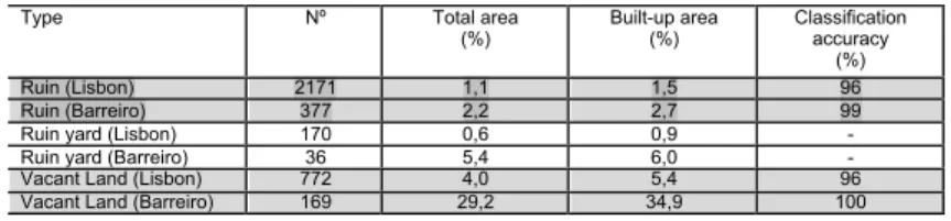
This paper will only look at two cities, Lisbon and Barreiro. Up to now we collected the comparative figures on Lisbon and Barreiro shown in table 1. In Lisbon (84.9 Km2) a total of 2 171 buildings in ruins were identified, which corresponds to 1.1% of the city area, while 772 plots of vacant land were found with a total area equal to 4% of the city. As for Barreiro (6.7 Km2) a total of 377 buildings in ruins were identified, equal to 2.2% of the area under study, along with 169 plots of vacant land that make up almost a third (29.2%) of the city perimeter14.
The second stage of the project will examine the potential of the urban spaces classified as abandoned land, from the architecture,
landscape architecture, geographic and ecologic standpoints as well as from the recreational, leisure and social standpoints.
The aim of the third stage is to discuss and create innovative urban spaces with landscape architecture and architecture solutions. The range of ruins, vacant land and abandoned ventures will be selected to propose meanwhile or permanent rehabilitation/reconversion programmes for those
116 7 . E CL A S Conf er enc e 201 7 . P ro ce edings
spaces as reference examples.
Many of the proposals will involve the
re-appropriation of public space or the occupation of terrains vagues or abandoned land. In this way, they aim to act as urban zone catalysts and regeneration projects. And the strategies employed will favour greater flexibility and
reversibility of access and uses. In order to ensure the spaces are used the proposals will include the organisation of events and activities, such as concerts, conferences and festivals, or gardens and facilities such as allotments, playgrounds, creative workshops, art galleries, community kitchens that can attract the public and bring investment and profitability to the project. Final remarks
From the landscape architecture, viewpoint for which the interventions may be of a temporary or permanent nature depending on the type of space and future town planning, this alternative approach to abandoned urban spaces is
acceptable, practical and may even constitute a particularly interesting challenge. In fact it is in line with a naturalist trend in green space design which is not new but has been gaining ground in recent years, and favours spontaneous, organic and authentic solutions, which can also be seen as a tribute to ecology and the wild.
Interest in the type of approach employed in the NoVOID project may be applied both to new areas of the city that are being eyed up by real state developers (so called zones in waiting), both in the centre of the city, in the so called vacant spaces of a perforated city, as well as in dilapidated neighbourhoods or the poorest parts of the city. The aim is to find and create provisional and permanent solutions for the selected spaces in the cities of Lisbon and Barreiro. The methodology employed in this project, together with the different types of
intervention proposed, could be used in the future in other cities.
1168 . E CL A S Conf er enc e 201 7 . P ro ce edings Endnotes
1 [] Solà-Morales, Ignacio. 1995. “Terrain vague.” In Davidson, C. (eds.) Anyplace, Cambridge, MA: MIT Press, p. 120
2 [] Clément, G. 2003. Manifeste du Tiers
paysage. Paris: Editions Sujet/Objet.
3 [] Jellicoe, Geoffrey; Jellicoe, Susan, 1995.
The Landscape of man: shaping the environment from prehistory to the present day. London:
Thames and Hudson, p. 261.
4 Olmsted, F. L. 1852. Walks and Talks of an
American Farmer in England. New York: George P.
Putnam, p. 79.
5 Lamas, J. M. R. G. 1993. Morfologia Urbana
e Desenho da Cidade. Lisbon: Fundação Calouste
Gulbenkian, p. 212.
6 [] Boults, E.; Sullivan, C., 2010. Illustrated
History of Landscape Design. New York: John
Wiley & Sons, p. 177.
7 [] Tate, A. 2015. Great city parks. New York: Routledge.
8 Telles, G. R. (coord.). 1997. Plano Verde de
Lisbon: componente do Plano Diretor Municipal de Lisbon. Lisbon: Edições Colibri, p. 42.
9 [] Tostões, A. 1992. Monsanto, Parque
Eduardo VII, Campo Grande. Lisbon: Edições
Salamandra. p. 67.
10 [] Girot, C. 2016. The Course of Landscape
Architecture - A History of our Designs on the Natural World, from Prehistory to the Present. London: Thames & Hudson, p. 291.
11 [] Colomb, C. 2012. «Pushing the urban frontier: temporary uses of space, city marketing, and the creative city discourse in 2000s Berlin ». Journal of Urban Affairs, 34 (2): 131-152. doi: 10.1111/j.14679906.2012.00607.x.
12 [] Foster, J. 2014. « Hiding in plain view: Vacancy and prospect in Paris’ Petite Ceinture ». In Cities, Volume 40, 2014, pp. 124-132. doi: 10.1016/j.cities.2013.09.002
13 Girot, C. 2016. The Course of Landscape
Architecture - A History of our Designs on the Natural World, from Prehistory to the Present.
Type Nº Total area
(%) Built-up area (%) Classification accuracy (%)
Ruin (Lisbon) 2171 1,1 1,5 96
Ruin (Barreiro) 377 2,2 2,7 99
Ruin yard (Lisbon) 170 0,6 0,9 -
Ruin yard (Barreiro) 36 5,4 6,0 -
Vacant Land (Lisbon) 772 4,0 5,4 96
Vacant Land (Barreiro) 169 29,2 34,9 100
Table 1 – Lisbon and Barreiro: quantification by defined categories (Ruin, Ruin yard and Vacant Land) 15. 1169 . E CL A S Conf er enc e 201 7 . P ro ce edings
14 Morgado , P.; Brito-Henriques, E.; Girão, I.; Batista, A.; Bozek, A. 2017. Open-data based methodology for detecting and analysing urban voids. II International Conference on “Urban e-Planning”, 20-21 April 2017 Lisbon.
15 Morgado , P.; Brito-Henriques, E.; Girão, I.; Batista, A.; Bozek, A. 2017. Open-data based methodology for detecting and analysing urban voids. II International Conference on “Urban e-Planning”, 20-21 April 2017 Lisbon.
11 70 . E CL A S Conf er enc e 201 7 . P ro ce edings
ECLAS Conference 2017 Creation/Reaction/ 10th > 13th September 2017 https://eclas2017london.com
Department of Architecture & Landscape 11 Stockwell Street
Greenwich London SE10 9BD