Introduction
Many applications of MODFLOW have been per-formed in the last decade (Harsh and Laczniak 1990; Love et al. 1994; Leaney and Herczeg 1995; Carreira et al. 1996). Recently, Harrington and others (1999) combined MODFLOW with the compartmental mixing-cell model to study the dynamics of ground water flow in the coastal basin of Otway, South Australia. In the following, we describe the simultaneous application of computational modeling, environmental isotopes (O-18, C-14) and electric conductivity measurements to a well field in a semiarid climate. For a review of theory and application of isotopes to ground and surface water, we refer to recent comprehensive books (Mook and de Vries
2000; Cook and Herczeg2000).
Significant reductions in the static level of an aquifer produce effects on the environment and on the circula-tion of ground water, and can induce vertical flows between adjacent aquifer units. These processes were observed in the sedimentary basin of the Cariri region, located in the semiarid zone of the Brazilian Northeast, in the municipal area of Juazeiro do Norte, Ceara´. In this region, the elevated demand for water, due to a high population density, increased during large pilgrimages, large-scale irrigation of sugar cane crops, cattle breed-ing, and an incipient industrialization, is satisfied exclusively by ground water exploitation.
Apart from intense pumping, the studied aquifers are subject to a regional climate that is characterized by an irregular spatial and temporal distribution of rainfall with two distinct seasons. Rain is essentially limited to
Luiz Alberto Ribeiro Mendonc¸a Horst Frischkorn
Marlu´cia Freitas Santiago Josue´ Mendes Filho
Isotope measurements and ground water
flow modeling using MODFLOW for
understanding environmental changes caused
by a well field in semiarid Brazil
Received: 11 July 2004 Accepted: 28 December 2004 Published online: 30 March 2005
Springer-Verlag 2005
Abstract Measurements of the envi-ronmental isotopes carbon-14 and oxygen-18 and of the electrical con-ductivity in ground water, together with MODFLOW-88 (DOS) simu-lations of pumping tests, were used to achieve a detailed understanding of the functioning of an aquifer in the area of a well field. The meth-odology was applied in the sedi-mentary basin of the Cariri region, in the south of Ceara´ State in Brazil. Localized hydraulic connections between adjacent aquifer units could be detected, and mixing ratios for the contributions from the units involved were determined. Cone of depression simulations for a three-year drought period revealed well
interference and a drastic lowering of the piezometric level, thereby explaining the hydrogeologic chan-ges and transformations in vegeta-tion that were observed in the area of the well field. The combined use of the modeling tools and the geo-chemical field observations is shown to provide more detailed insight into the conceptual model of the
groundwater flow system.
Keywords Environmental isotopesÆ MODFLOWÆSemiarid Brazil Æ Well field
L. A. R. Mendonc¸aÆM. F. Santiago (&) J. M. Filho
Departamento de FI´sica da UFC, Caixa Postal 6030, 60455-970 Fortaleza, Brazil E-mail: marlucia@fisica.ufc.br
Tel.: +55-85-32889913 Fax: +55-85-32889450
H. Frischkorn (&)
Departamento de Engenharia Hidra´ulica e Ambiental da UFC, Caixa Postal 6006, 60455-970 Fortaleza, Brazil
5 months, from February to June, the rest of the year being dry. Moreover, periods of drought, when annual precipitation is much lower than average levels for up to five consecutive years, occur in the region, resulting in decreased recharge of the aquifer system.
As recharge only occurs during periods of abundant precipitation, the high variability in annual rainfall in the region causes an even higher variability of recharge of the aquifers. Consequently, water tables exhibit great annual fluctuations. Thus, a detailed understanding of the functioning of aquifers and the behavior of the well field in extreme situations of drought is necessary in or-der to avoid environmental damage or even shut-down of wells due to interference caused by excessive pumping. In the present study, the effects on the aquifer system due to the variation in its static level, caused by intense pumping and/or reduced recharge during years of drought, were analyzed. Localized vertical leakage be-tween adjacent aquifer units could be detected. For this analysis, measurements of the isotopes oxygen-18 and carbon-14, and electric conductivity were used together with pumping tests and MODFLOW-88 (DOS) (Mc Donald and Harbaugh 1988) simulations for the char-acterization of the waters from semi-confined and con-fined aquifers (we used the MODFLOW-88 version that is slightly more complicated to use than modern ones, but is free). The isotope and electric conductivity parameters allow, for each well, the determination of the mixing ratios of the contributions from each aquifer.
Area of study
The sedimentary Cariri region, in the very south of Ceara´ State, consists of a plateau, the ‘‘Chapada do
Araripe’’, and a valley, the ‘‘Vale do Cariri’’, on its northern slope (Fig.1). In contrast to the crystalline basement area that covers about 75% of Ceara´ state, the Cariri Region has rich ground water resources. In the Cariri Valley, the sedimentary sequence (Ponte and Appi
1990) is composed of the formations (from the top to the crystalline base) Rio da Batateira, Abaiara, Missa˜o Velha, Brejo Santo and Mauriti. Rio da Batateira is a semi-confined aquifer, and Missa˜o Velha and Mauriti are aquifers confined respectively by the aquitards Abaiara and Brejo Santo (Fig.1).
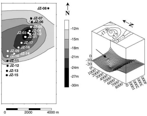
Public water supply to the town of Juazeiro do Norte is based on two neighboring well fields (Fig.1), one (field 1, with wells Jz-01 to Jz-08 and Jz-14, Jz-16, and Jz-17) along the Macacos creek, and the other (field 2, with wells Jz-09 to Jz-13 and Jz-15) along the main access road to Juazeiro do Norte. Figure2shows the stratigraphy along section AB (well field 1), con-structed by interpolation of the drilling logs of the production wells. A localized discontinuity in the Abaiara aquitard can be observed in the vicinity of well Jz-06. In the area of well field 2, the geological stratum is uniform and no discontinuities in the confinement layer at the base of the aquifer are found. For this reason, we focus our attention on field 1. Field 1 began operation in the 1970s and field 2 in the 1980s. The entire set (both fields) consists of 17 wells, with a maximum production of 2,592 m3/h, being pumped 24 h a day.
Secondary effects of ground water extraction
During a five-year drought, from 1989 to 1993, water levels dropped dramatically and secondary effects of
excessive ground water exploitation appeared. Neigh-boring wells with depths less than 30 m dried up. The same happened to creeks and the ponds Lagoa Seca and Lagoa dos Macacos, in the surrounding area of field 1, which were formerly perennial. The area suffered a transformation from wet to dry, accompanied by a change in the vegetation cover. The old forest trees died and were replaced by a steppe type of vegetation. Private small properties, used for weekend farming and recrea-tion, were abandoned. Subsequent abundant rainfall during the three-year period from 1994 to 1996 partially recovered the static level in the Rio da Batateira aquifer. However, the environmental changes persisted as the creeks and ponds remained dry and the previous land-scape did not return.
Methodology
The geological stratigraphy and the structure of the aquitard separating the Rio da Batateira and Missa˜o Velha aquifers were determined using geological studies of the area and the drilling profiles of the wells.
Measurements of isotopes carbon-14 and oxygen-18 and electric conductivity on samples from the 11 wells of field 1 were performed to characterize the water origi-nating from the Rio da Batateira and Missa˜o Velha aquifers and to evaluate the degree of mixing of ground water derived from both aquifers. Electric conductivity measurements were made in situ. Analyses ford18O were done by Hydroisotop/ Schweitenkirchen, Germany (with an error of ±0.15&). Carbon-14 was measured in
our ‘‘Laborato´rio de Carbono-14’’ at the Federal Uni-versity of Ceara´, UFC, in Fortaleza.
Data from two pumping tests, conducted on wells Jz-05 and Jz-02, were used to assist in the interpretation of the hydraulic characteristics of the aquifer system. Numerical analysis of the pumping test data was per-formed using MODFLOW-88. Two hydrogeologic conceptual models were considered. In the first, the Rio da Batateira aquifer was considered confined at its base; in the second, a hydraulic connection of the Rio da Batateira aquifer to the lower Missa˜o Velha aquifer was included.
To understand the environmental effects observed in the area of the well field during prolonged drought conditions, MODFLOW was used to simulate the pie-zometric surface for the whole well field.
For the modeling applications, the following data were used:
– pumping tests on all wells with drawdown observation in the well pumped (aquifer transmissivity values); – drawdowns in wells Jz-01 when pumping Jz-02, and in
Jz-04 and Jz-06 when pumping Jz-05 (aquifer storage coefficients);
– static levels in wells Jz-01 and Jz-10 in 1989, Jz-05 in 1992, and Jz-06, Jz-08 and Jz-16 in 1996, inactive during the respective years, used as calibration points; – pumping rates for all wells between 1976 and 1996.
For simulation, a 19-column/22-row grid (covering an area of 10 km by 12 km with the area of interest at its center, with average grid block size of about 0.3 km2) was used. Columns were south to north oriented,
lowing natural groundwater flow as observed from hydraulic head data. An area significantly greater than this is of little utility, since there are no hydrogeologic data available outside the well fields. Specified head boundary conditions were imposed on all lateral boundaries: for each period of simulation, these were changed to reflect measured water levels. Thus, lowering of the head outside the area of influence of the well fields takes account of the lack of recharge of the aquifer outside the cone of depression during drought years. The base of the simulation domain was considered imper-meable, with the exception of cells where hydraulic leaks are located. In the surface boundary conditions, re-charge was neglected as it is estimated to amount to about 24 mm/year only (Mendonc¸a 2001; GVJ 1967), whereas the production of the two well fields corre-sponds, in the area of simulation, to about 190 mm/ year. Based on pumping test data (with observation in the well itself) from the period of drilling (Table1), transmissivity values were assigned to columns the fol-lowing way: to a cell containing a well, the well value is attributed; to cells (from the same column) between two wells, the mean values are assigned; outside the well field, the value for the nearest well in the column is used; to columns without wells, the mean of the nearest one or ones with wells was attributed.
Geochemical evidence of ground water mixing between the two aquifers
By studying the ground waters of the sedimentary basin of the Cariri, Santiago and others (1997) observed that the waters from the aquifers Rio Batateira, Missa˜o Velha, and Mauriti (Fig.1) can be distinguished by correlations between the values for carbon-14, oxygen-18, and electric conductivity. Compared to waters from the Missa˜o Velha aquifer, those of the Rio da Batateira aquifer have lower electric conductivity and higherd18O and pmC values.
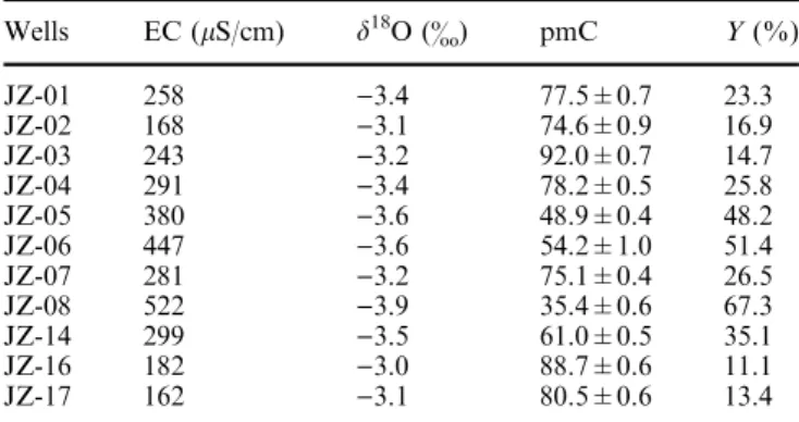
Electric conductivity (EC) and isotope data for samples from the wells of well field 1 are listed in Table2. Corresponding graphs are shown in Fig.3.
Correlation between the parameters is clear: lower pmC is associated with more negative d18O and higher EC, indicating the presence of old waters. Stute et al. (1995) and Frischkorn et al. (1984) showed, for ground water of that region, that oxygen-18 depletion signifi-cantly greater than in present day rainfall (d18O)3&)
is associated with water ages higher than10,000 years. Such waters are marked by a colder paleoclimate. Due to their elevated age, mineralization is generally high. Based on the geochemical differences in the deep and shallow aquifers, the observed behavior indicates the mixing of recent recharge waters (Rio da Batateira Aquifer), of d18O derived from present day rainfall and of low min-eralization, with paleowaters (from the Missa˜o Velha Aquifer). Consequently, plots of d18O versus pmC (Fig.4a) and EC versus pmC (Fig.4b) exhibit mixing lines between end points with pmC=0, d18O=)4.3& and EC=694lS/cm (for old water), and pmC=100, d18O=)3.0&, and EC=120 lS/cm (for young water). As EC and pmC exhibit relative variations (in relation to their errors) much greater thand18O, these two param-eters were used, in combination, for assigning mixing ratios for the two components to each well (Table2).
Figures5a and b demonstrate that, in addition to EC and pmC,d18O is well represented by the same relative contributionsY. This analysis shows that, in the area of
Table 1 Transmissivity coefficients (·10)3m2/s) used in MODFLOW modeling
JZ 01 02 03 04 05 06 07 08 09 10 11 12 13 14 15 16
well field 1, an average contribution of about 30% to the waters of the Rio da Batateira aquifer originates from the underlying Missa˜o Velha aquifer through upward leakage.
MODFLOW drawdown simulation
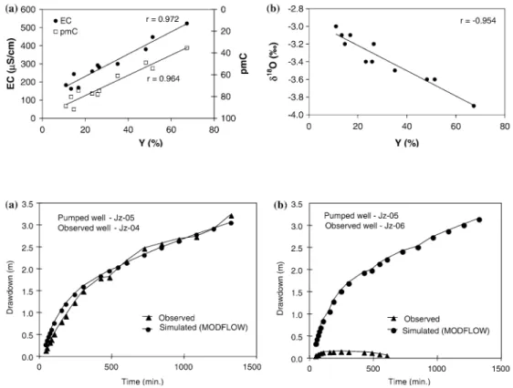
At the time of installation of well field 1, with well field 2 still not existing, pumping tests were performed in wells Jz-02 and Jz-05 (Fig. 1) with drawdown observation in neighboring wells. Each test had a duration of 48 h for pumping and recovery. Constant discharge was 144 m3/h. Drawdowns were observed in well Jz-01, for the pumping of Jz-02, and in wells Jz-04 and Jz-06, when pumping Jz-05.
At the beginning of exploitation, a spring existed in the area of the well field and, due to the presence of clayey layers, artesian conditions were observed locally. Thus the ‘‘confined’’ condition of MODFLOW was used in the simulation, requiring transmissivity, storage coefficient and hydraulic head data only. Two hydraulic parameters for the Rio da Batateira aquifer were ob-tained by using Jacob’s method. In wells Jz-01, Jz-04 and Jz-06 the transmissivities were 3.2·10)3m2/s, 3.1·10)3m2/s, and 48·10)3m2/s, respectively. The
storage coefficients were 1.77·10)4, 2.71·10)4, and 10.1·10)4, respectively.
Hydraulic parameters for the Missa˜o Velha aquifer and the separating aquitard are given in the following section.
Vertical flows
Drawdowns from pumping tests were simulated in three different conditions, fixing transmissivities and adjusting storage coefficients, as follows: (1) aquifer with no hydraulic connection to the underlying aquifer; (2) same as before, but taking into account natural south to north ground water flow at a 4& gradient and (3) leaky aquifer, with a connection to the subjacent aquifer Missa˜o Velha (maintaining natural ground water flow). The results for the first simulated condition are shown in Figs.6a and b, corresponding respectively to the data of the observed wells, Jz-04 and Jz-06, when well Jz-05 is pumped. It is evident that this condition cannot simulate the field data for well Jz-06.
Taking into account ground water flow (condition 2) improved the simulation slightly (not shown here), without leading to satisfying results. Finally, condition (3), for a leaky aquifer, yields a good simulation of the field data for well Jz-06 as can be seen in Figs.7a and b. This shows that the first two simulations are in essence the same, because the problem does not lie in the initial head distribution. The main problem lies in the vertical boundary condition—whether the layer at the bottom of the uppermost aquifer is confining or leaking.
This third simulation was for a leaky Rio da Ba-tateira aquifer. For obtaining a storage coefficient, nee-ded in that exercise, for the underlying Missa˜o Velha aquifer, we used the equation of Haghunath (1982), with an average thickness of 150 m (Berthou 1994; Dantas and Lopes 1995), an average porosity of 15%, and a modulus of compression of 14.7·108N/m2. That way, S10)3was found for the Missa˜o Velha aquifer. Then simulation of Jz-06 drawdowns resulted in a transmis-sivity of 5.3·10)2m2/s for that aquifer. Based on the isotope and electric conductivity results (Fig.7) and also
Fig. 4 Linear correlations for d18O and pmC (a) and for
electric conductivity (EC) and pmC (b)
Table 2 Electric conductivity, oxygen-18 (d&, VSMOW) and carbon-14 (pmC) for wells in the Rio da Batateira aquifer and the relative contribution from the old component,Y, from the Missa˜o Velha aquifer
Wells EC (lS/cm) d18O (&) pmC Y(%)
JZ-01 258 )3.4 77.5±0.7 23.3
JZ-02 168 )3.1 74.6±0.9 16.9
JZ-03 243 )3.2 92.0±0.7 14.7
JZ-04 291 )3.4 78.2±0.5 25.8
JZ-05 380 )3.6 48.9±0.4 48.2
JZ-06 447 )3.6 54.2±1.0 51.4
JZ-07 281 )3.2 75.1±0.4 26.5
JZ-08 522 )3.9 35.4±0.6 67.3
JZ-14 299 )3.5 61.0±0.5 35.1
JZ-16 182 )3.0 88.7±0.6 11.1
on the geological stratigraphy (Fig.2), a localized discontinuity in the aquitard, near well Jz-06, was introduced. Simulation, for the same constant discharge of 144 m3/h from well Jz-05, resulted in a leakage (quantified in terms of the leakage coefficient, defined as vertical hydraulic conductivity divided by the thickness of the confining layer (De Smedt 1998), expressing the leaking capacity of the aquitard) of 2·10)5s)1in the cell of well Jz-06 and 10)7s)1in neighboring cells. Based on the artesian pressure of this well after drilling (Ceara´
1988), a hydraulic head of 4.85 m above initial head in the upper aquifer was assumed, constant for the 48 h pumping test. For the Rio da Batateira aquifer, the transmissivities and storage coefficients obtained from the pumping tests were used for this simulation. As a
result, for well Jz-06, transmissivity and storage coeffi-cient adjust to the normal Rio da Batateira values also for this test, 3.7·10)3m2/s and 2.71·10)4, respectively.
Scenarios for environmental impacts
Aiming at an understanding of the environmental changes that occurred in the area around 1992 and that, certainly, were induced by the lack of recharge and due to the arrangement of wells in fields with interference, we simulated the piezometric surface in the whole area for various years and for the real pump rates.
The 1989 simulation, not shown here, revealed localized cones of depression for individual wells
Fig. 7 Drawdown observed and simulated for a leaky aqui-fer
Fig. 6 Drawdown observed in wells Jz-04 (a) and Jz-06 (b) when pumping well Jz-05 and simulation with confinement at the base of the aquifer Fig. 5 Electric conductivity, EC, (a) and pmC (b) in the Rio da Batateira aquifer, as a func-tion of the relative contribufunc-tion,
without interference, thus limiting the influence of each well to its immediate vicinity. (All drawdowns are given in relation to the ‘‘natural’’ level in the aquifer, in 1976, before production began.)
However, the simulation for 1992, after 3 years of drought, for a production of 1,690 m3/h (24 h), exhibits a lowering of the piezometric surface in the area through interference of cones of depression, with the water level reaching about 30 m and affecting an area of about 15 km2(Fig. 8shows a zoomed Surfer representation of the simulation). The hydraulic head in the Missa˜o Velha aquifer lowered by about 7.60 m. These results explain the environmental impact of drying up Lagoa Seca and diminishing the volume of Lagoa dos Macacos, as well as emptying Rio da Batateira. In this condition of stress, the contribution of ascending waters from the Missa˜o Velha aquifer, feeding the upper aquifer, can clearly be seen in Fig. 8.
It is noteworthy that this simulation shows that a pumping rate of 1,690 m3/h is a hydraulically safe con-dition in the sense that none of the wells fall dry, even though it turned out to impose undesirable environ-mental impacts.
We have made simulations also for the maximum production of 2,592 m3/h in the same 1992 conditions (three consecutive years of drought) that result in the breakdown of the well field due to drying up of its central part and thus demonstrated that the projected pumping rates are unsustainable during prolonged drought conditions.
For 1996 the production was 2,073 m3/h (24 h). Due to ample rainfall during the three previous years, a good recovery of the aquifer system is observed (Fig. 9). The maximum dynamic level recovered to 18 m and the hydraulic head in the lower aquifer (Missa˜o Velha) in-creased to 5.80 m, demonstrating the elevated recharge of the aquifer system.
Seasonal variations of electric conductivity were ob-served for Jz-06: at the end of the rainy season 2002, in June and July, 488 and 476lS/cm, respectively; and at the end the dry season, November-02 and January-03, 549 and 574lS/cm, respectively. This indicates changing composition of water from this well, depending on the piezometric level. In periods of reduced rainfall, as in 1992, low pressure in the upper aquifer is expected to intensify upward leakage. In years of increased recharge, the phenomenon is partially inverted: depression cones decrease and the hydraulic head in the lower aquifer recovers.
Conclusions
The synoptic evaluation of environmental isotope (d18O, pmC) and electric conductivity measurements and MODFLOW aquifer modeling results in a detailed understanding of the functioning of the two aquifers Rio da Batateira and Missa˜o Velha in an area of heavy exploitation. The simulation of the variation of draw-down with pumping time for wells in the Rio da
Batateira aquifer allows the detection of hydraulic con-nections with the underlying confined aquifer, Missa˜o Velha, and the existence of vertical ascending flows.
Measurements of carbon-14 and oxygen-18 in sam-ples from wells at and near the connections reveal mix-tures from the two aquifers. The waters from the confined aquifer are characterized by pmC0, EC 694lS/cm and d18O)4.3&. The waters from the Rio da Batateira aquifer (or better: recharge waters) are characterized by pmC100, EC120lS/cm and d18O )3.0&. These two components represent the end points of mixing lines.
Simulation of the piezometric surface in the area with localized observations for calibration, before (in 1989) and during a period of drought (in 1992), made it pos-sible to identify a lowering of the piezometric surface of up to 30 m. This corresponds to conditions in which Lagoa Seca and Riacho dos Macacos dried up. Obvi-ously, the exploitation of aquifers through well fields in a semiarid climate causes, during multiple-year droughts, a depression of the piezometric surface of great pro-portions inducing environmental changes.
Even though the aquifer system observed responds well to recharge and partially recovered after 1992 due to good rainfall in the following years, water levels did not recover completely; the intermittency of ponds and creeks persisted and associated transformations in vegetation continue until now. Most probably,
envi-ronmental changes are irreversible since droughts occur in the northeast of Brazil with an average periodicity of 5 years or so (Girardi 1992); severe drought events re-cur with a periodicity of about 13 years (Markham
1974).
In general, water resource planning is based on ‘‘normal’’ conditions defined through mean values. In semiarid regions, however, inter-annual variations of rainfall are extremely high; drought periods of several years may occur. In these conditions, ground water exploitation through well fields carries elevated envi-ronmental risks since well interference may lead to widespread water level depression in dry years. Thus, a detailed knowledge of the functioning of aquifers is re-quired and should be combined with computational modeling in order to assess aquifer behavior under ex-treme climate conditions.
However, we find it too difficult to define environ-mentally safe pumping rates, as in the case of the Jua-zeiro do Norte well field the entire population of the town depends on these wells—especially during droughts, when shallow private wells fall dry.
Acknowledgements We owe thanks to the state and federal fund-ing agencies, respectively, FUNCAP and CNPq, for financial support, and to Hydroisotop/ Germany ford18O measurements. The local water companies CAGECE and COGERH provided logistic support. Karen Pennesi and Anthony Donegan edited the paper.
References
Berthou PY (1994) From siliciclastic to carbonated sedimentation along the Rio da Batateira section (Araripe Basin, Crato/ NE Brazil): type sections description for ‘‘funda˜o’’, ‘‘Rio da Ba-tateira’’ and ‘‘Crato’’ lithostratigraphic units. Departamento Nacional de Pes-quisas Minerais/ DNPM, Recife-Brazil Carreira PM. Soares AMM, Marques da
Silva MA, Araguas L, Rozanski K (1996) Application of environmental isotope methods in assessing ground water dynamics of an extensively exploited coastal aquifer in Portugal. In: Isotopes in water resources man-agement, Proceedings of a symposium on isotopes in water resources manage-ment. International Atomic Energy Agency, Vienna-Austria, pp 45–58 Ceara´ (1988) Captac¸a˜o de Juazeiro do
Norte: condic¸a˜o de explorac¸a˜o dos po-c¸os - relato´rio de conclusa˜o. Compahia de A´gua e Esgotos do Ceara´/ CAGE-CE, Fortaleza-Brazil
Cook PG, Herczeg AL (eds) (2000) Envi-ronmental tracers in surface hydrology. ISBN 0-7923-7707-9, Kluwer, Dordr-echt
Dantas JRA, Lopes CF (1995) A bacia sedimentar do Araripe. Departamento Nacional de Pesquisas Minerais/ DNPM, Recife-Brazil
De Smedt F (1998) Two- and three-dimen-sional flow of groundwater. In: Delleur JW (ed) The handbook of groundwater engineering. CRC, Boca Raton, pp 3.1–3.27
Frischkorn H, Torquato JRF, Santiago MMF (1984) Medidas isoto´picas em aqu¨ı´feros profundos na regia˜o centro-oeste do Piauı´. In: III Congresso Bra-sileiro de A´guas Subterraˆneas, no. 2: 42–51.Associac¸a˜o Brasileira de A´guas Subterraˆneas/ABAS, Sa˜o Paulo-Brazil Girardi C (1992) Progno´stico de perı´odo de
seca para o nordeste brasileiro. In: Se-mina´rio de Tropicologia: tro´pico e cul-tura, 244–252. Fundac¸a˜o Joaquim Nabuco/FUNDAJ, Recife-Brazil GVJ (1967) Estudo geral de base do Vale
do Jaguaribe: Hidrogeologia. Superin-tendeˆncia do Desenvolvimento do Nordeste/SUDENE, Recife-Brazil Haghunath HM (1982) Ground water.
Wiley, New Delhi
Harrington GA, Walker GR, Love AJ, Narayan KA (1999) A compartmental mixing-cell approach for the quantita-tive assessment of ground water dynamics in the Otway Basin, South Australia. J. Hydrol 214(1–4): 49–63 Harsh JF, Laczniak RJ (1990)
Conceptual-ization and analysis of ground water flow system in the Coastal Plain of Virginia and adjacent parts of Maryland and North Carolina. U.S. Geological Survey Professional Paper 1404–F Leaney FW, Herczeg AL (1995) Regional
recharge to karst aquifer estimated from chemical and isotopic composition of diffuse and localized recharge, South Australia. J Hydrol 164:363–387 Love AJ, Herczeg AL, Leaney FW, Stadter
MFF, Dighton JC, Amstrong D (1994) Ground water residence time and pala-eohydrology in the Otway Basin, South Australia:2H,18O and14C data.
J Hydrol 153:157–187
Markham GC (1974) Apparent periodici-ties in rainfall at Fortaleza, CE-Brazil. J Appl Meteorol 13(1):176–179 McDonald MG, Harbaugh AW (1988) A
modular three-dimensional finite-differ-ence ground-water flow model. Tech-niques of Water Resources
Investigations of the U.S. Geological Survey Book 6, chap A1
Mendonc¸a LAR (2001) Recursos Hı´dricos da Chapada do Araripe. Ph.D. thesis, Departamento de Engenharia Hidra´u-lica e Ambiental, Universidade Federal do Ceara´. Fortaleza-Brazil
Mook W, de Vries (2000) Environmental isotopes in the hydrogeological cycle; principles and applications. Interna-tional Atomic Energy Agency/IAEA, Vienna/Austria
Ponte FC, Appi CJ (1990) Proposta de revisa˜o da coluna litoestratigra´fica da Bacia do Araripe. In: XXXVI Con-gresso Brasileiro de Geologia, Natal-Brazil, 1:211–226
Santiago MMF, Silva CMSV, Mendes Fil-ho J, Frischkorn H (1997) Character-ization of ground water in the Cariri (Ceara´, Brazil) by environmental isotopes and electric conductivity. Radiocarbon 39(1):49–59