www.clim-past.net/10/811/2014/ doi:10.5194/cp-10-811-2014
© Author(s) 2014. CC Attribution 3.0 License.
Climate
of the Past
Comparing modelled fire dynamics with charcoal records
for the Holocene
T. Brücher1, V. Brovkin1, S. Kloster1, J. R. Marlon2, and M. J. Power3
1Max Planck Institute for Meteorology, Hamburg, Germany
2School of Forestry and Environmental Studies, Yale University, New Haven, CT, USA
3Natural History Museum of Utah, Department of Geography, University of Utah, Salt Lake City, UT 84112, USA Correspondence to:T. Brücher ([email protected])
Received: 28 October 2013 – Published in Clim. Past Discuss.: 27 November 2013 Revised: 25 February 2014 – Accepted: 28 February 2014 – Published: 24 April 2014
Abstract.An earth system model of intermediate complex-ity (CLIMate and BiosphERe – CLIMBER-2) and a land surface model (JSBACH), which dynamically represent veg-etation, are used to simulate natural fire dynamics through the last 8000 yr. Output variables of the fire model (burned area and fire carbon emissions) are used to compare model results with sediment-based charcoal reconstructions. Sev-eral approaches for processing model output are also tested. Charcoal data are reported inZ-scores with a base period of 8000–200 BP in order to exclude the strong anthropogenic forcing of fire during the last two centuries. The model–data comparison reveals a robust correspondence in fire activity for most regions considered, while for a few regions, such as Europe, simulated and observed fire histories show different trends. The difference between modelled and observed fire activity may be due to the absence of anthropogenic forc-ing (e.g. human ignitions and suppression) in the model sim-ulations, and also due to limitations inherent to modelling fire dynamics. The use of spatial averaging (orZ-score pro-cessing) of model output did not change the directions of the trends. However,Z-scotransformed model output re-sulted in higher rank correlations with the charcoalZ-scores in most regions. Therefore, while both metrics are useful, processing model output asZ-scores is preferable to areal av-eraging when comparing model results to transformed char-coal records.
1 Introduction
The current interglacial period, the Holocene, that started about 11 650 cal yr BP (Masson-Delmotte et al., 2013), is characterized by a relatively stable climate. The main cli-matic and environmental changes resulted primarily from slow changes in orbital forcings. The maximum of incom-ing summer solar irradiance in the Northern Hemisphere was about 11 000 cal yr BP, when it was higher by ca. 50 W m−2 (65◦N: 528.45 W m−2 at 11 000 cal yr BP; Berger, 1978; Berger et al., 1998; Tzedakis et al., 2012). However, un-til about 9000 cal yr BP, the climate in the northern temper-ate and high latitude regions was strongly affected by the remains of the northern hemispheric ice sheets. Based on terrestrial proxy records, a time slice of 6000 cal yr BP was chosen as a data–model comparison reference period for the mid-Holocene by the Paleoclimate Modelling Intercompari-son Project (PMIP, Braconnot et al., 2007).
available pollen records with the tree cover changes (Kleinen et al., 2011). Progress in the synthesis of the Holocene land cover and land use changes (e.g. Gaillard et al., 2010) and climate proxy records (Marcott et al., 2013) now provides a basis for detailed model–data comparison throughout the Holocene period.
Fire is an important process that affects climate through changes in CO2emissions, albedo, and aerosols (Ward et al., 2012). In addition, it disturbs vegetation distribution (Sitch et al., 2003). Fire-history reconstructions from charcoal ac-cumulations in sediment have indicated that biomass burning has increased since the last glacial maximum (Power et al., 2008; Marlon et al., 2013). Recent comparisons with tran-sient climate model output suggest that this increase in global fire activity is linked primarily to variations in temperature and secondarily to variations in precipitation (Daniau et al., 2012). A new aspect of the recent generation of Earth System Models (ESM) is the implementation of fire models (Arora and Boer, 2005; Kloster et al., 2010; Thonicke et al., 2010; Pfeiffer et al., 2013) that allow testing hypotheses gener-ated through reconstructions of palaeofire data on the con-trols of fire across a range of spatial and temporal scales. Fire model outputs have included simulated burned areas and CO2 emissions that can be evaluated against present-day observations from remote-sensing products. For exam-ple, Kloster et al. (2010) demonstrated that the Arora and Boer (2005) fire model implemented in the Community Land Model (CLM-CN) reproduces reasonable patterns and an-nual cycles of burned area and carbon emissions within the range of satellite-based observations. Simulated mean burned area (327 Mha yr−1) was at the lower band of satellite obser-vations (329 to 401 Mha yr−1), and modelled carbon emis-sions varied between 2.0 and 2.4 Pg C yr−1, also close to the low end of satellite-based products (2.3 and 2.7 Pg C yr−1).
Recent progress in the analysis and syntheses of charcoal records led to a Global Charcoal Database with hundreds of records from around the world (Power et al., 2008; Daniau et al., 2012). To analyse the temporal changes in the char-coal database, individual charchar-coal records are transformed and standardized to allow comparisons across the multiple types of records (e.g. Power et al., 2008; Marlon et al., 2009; Daniau et al., 2012; Marlon et al., 2013). The standardization allows analysis of trends in different regions using charcoal records obtained from a wide range of depositional environ-ments and quantified with different laboratory techniques.
Some recent studies compare fire model results on a lo-cal (Feurdean et al., 2013) or regional slo-cale (Molinari et al., 2013) to a composite or single site measurements of charcoal. In this study we use the advantages offered from a mechanis-tic global model and ask “What factors are causing the vari-ations in fire?” and analyse how well fire models reproduce reconstructed trends in fire activity during the last 8000 yr. Second, we ask “How well can global fire models reproduce reconstructed fire activity?” and from a methodological per-spective, “What is the best way to compare global fire model
output with charcoal records?”. The last question is impor-tant because (i) the fire model provides quantitative infor-mation about burned area and fire-related emissions of CO2, but charcoal-based palaeofire data only provide information about relative changes in biomass burning for specific re-gions and time periods; and (ii) since the charcoal records are interpreted via a non-linear power transformation, the model can be used to relate trends in charcoal to trends in quantitative changes in burned area or fire carbon emissions; for example, does a 2× increase in the standardized char-coal reconstruction reflects a 2×, 200×, or some other in-crease in area burned? The essential steps in answering these questions are to test how well the model can reproduce the reconstructions, develop metrics for characterizing the com-parisons, and to understand how the data transformation and standardization affects the model output.
In the following, Sect. 2 describes the data and model used in this study in detail, including the transformation and standardization of model output toZ-scores. Section 3 dis-cusses the drivers of variation, comparison of model results and charcoal data on (i) large (continental) and (ii) regional (sub-continental) spatial scales followed by a summary of key findings in Sect. 4.
2 Methods
2.1 Charcoal reconstructions
subtracting the minimum value min(cis) and divide by the amplitude (max(cis)−min(cis)) of the time series.
ci′s = cis−min(cis)
max(cis)−min(cis)
(1) The non-linear Box–Cox transformation ci∗
s (Eq. 2) re-duces high numbers and removes outliers to achieve a more Gaussian-like distribution (e.g. Fig. 3 in Power et al., 2008):
ci∗s = ((ci′
s+α)λs−1
λs λs 6=0
log ci′s +α
λs =0
. (2)
Here, the parameter λs is estimated by a maximum-likelihood method (Venables and Ripley, 1994) for each time series at each charcoal site (s) separately. To avoid a division by zero, a small constantαis added (here:α= 0.01). After-wards, the minimax and Box–Cox transformed time series ci∗
s (Eq. 2) is normalized by subtracting the mean value of a predefined base period ci∗s and dividing the anomalies by the standard deviationSci∗
s of the minimax and Box–Cox
trans-formed time series ci∗
s (Eq. 2): ciZs = ci
∗ s −ci∗s
Sci∗
s
. (3)
To retrieve regional, aggregated valuesZregion out of the site information ciZs (Eq. 3), all time series ciZs are lin-early averaged (Eq. 4) by deviding with the number of sites (Nsites):
Zregion =
X
sites ciZs
Nsites. (4)
Even though theZ-score transformation is not linear it is still rank conserving. In order to calculate area composites, each record was sampled (without interpolation) at 20 yr inter-vals and afterwards smoothed (LOcally-WEighted regression Scatter plot Smoother – LOWESS) by running a 250 yr mov-ing window. Furthermore, a bootstrap analysis (samplmov-ing by site) was used to obtain the 95 % confidence intervals for the
Z-score of a region.
CLIMBA – a fast global carbon cycle model
The computational efficiency of ESMs is rather low, there-fore it is a challenge to do interactive simulations over the Holocene, as, for example, done by Fischer and Jungclaus (2010); furthermore, adding an interactive carbon cycle in-creases the complexity. Combining a model of intermedi-ate complexity with a land model of full complexity bridges the gap between long simulations and computational effi-ciency on the quality of the simulated climate. For this study we developed a new coupled climate–carbon cycle model CLIMBA. It consists of the earth system model of interme-diate complexity (EMIC) CLIMBER-2 (CLIMate and Bio-sphERe) (Petoukhov et al., 2000; Ganopolski et al., 2001)
and JSBACH (Reick et al., 2013; Schneck et al., 2013; Brovkin et al., 2009; Raddatz et al., 2007), which is the land component of the Max Planck Institute Earth System Model (MPI-ESM; Giorgetta et al., 2013). While CLIMBER-2 sim-ulates the atmosphere and land processes at roughly 51◦ (lon-gitude) by 10◦(latitude), the JSBACH model runs on higher spatial resolution (3.75◦longitude by 3.75◦latitude) includ-ing a daily cycle to better resolve heterogeneous land pro-cesses. The coupling procedure between CLIMBER and JS-BACH is analogue to the coupling described in Kleinen et al. (2010). As base climate daily values of MPI-ESM CMIP5 simulation for the early industrial period (here defined as 1850–1899) are used. The JSBACH module is driven by cli-mate anomalies (w.r.t. the base clicli-mate) from CLIMBER-2 added on a randomly chosen year out of the 50 yr spanning base climate. As CLIMBER-2 does not simulate year-to-year climate variability, this coupling approach ensures variabil-ity at this timescale within the forcing for JSBACH, which is critical for simulating fire in JSBACH. Because the base cli-mate is chosen from the pre-industrial simulation, the year-to-year variability is given by the variability of the base cli-mate alone. The clicli-mate forcing includes values for tempera-ture, precipitation, radiation balance, and atmospheric CO2 concentration. Given this climate and orbital forcing, JS-BACH runs offline for one model-year. The simulated change in the total land carbon feeds back to CLIMBER-2 as a car-bon flux to the atmosphere (negative or positive) and closes the carbon cycle. This coupling scheme does not allow us to account for biogeophysical feedbacks linked to changes in burned area, as the CLIMBER and JSBACH models are only coupled via the carbon cycle. The biogeophysical ef-fects from changes in vegetation distributions are solely sim-ulated by the land surface model of CLIMBER-2 (Brovkin et al., 2002).
JSBACH includes a dynamical vegetation scheme and cal-culates disturbance of vegetation by natural fire occurrence and windthrow. While the default JSBACH version (Reick et al., 2013) uses a simple fire module (Brovkin et al., 2009), the fire algorithm used in this study is based on Arora and Boer (2005), which simulates fire occurrence as a function of fuel availability, fuel moisture, and ignition source (Kloster et al., 2010; Krause et al., 2014). The fire model calculates a potential burned area, which is simulated as a function of fuel moisture and wind speed. Fuel moisture is not explicitly sim-ulated in the model. Soil moisture is taken as a proxy for fuel moisture. The associated carbon emissions are calculated as a function of area burned and available fuel load. There is no distinction as to whether carbon is emitted as CH4or CO2.
Kloster et al. (2010) shows, that the Arora and Boer (2005) algorithm implemented in the Community Land Model (CLM-CN) reproduces reasonable patterns and annual cy-cles of burned area and carbon emissions within the range of satellite-based observations.
the changing climate of the Holocene. We also do not account for human ignitions and anthropogenic land use or anthro-pogenic land cover changes and acknowledge these factors can impact the carbon cycle. Therefore, the research focus is designed to explore potential vegetation and natural fire occurrence.
2.2 Experimental set-up
A transient simulation spanning 8000 yr has been per-formed starting at the mid-Holocene at 8000 cal yr BP (8 ka = 8000 cal yr BP; 0 ka = 1950 AD). The initial condi-tions are taken from a control simulation with CLIMBA at 8000 cal yr BP with an atmospheric CO2 concentration of 260 ppm, in accordance with the reconstruction from ice core (Elsig et al., 2009). The transient simulation includes an or-bital forcing after Berger (1978), fixed greenhouse gases and aerosol concentration, and ignores changes in sea level and land ice. At the end of the transient simulation, atmospheric CO2 concentration is simulated as 272 ppm, which is lower than observed by ca. 8 ppm (Monnin et al., 2004). As the focus of this study is on natural vegetation and natural fire occurrence, anthropogenic land use emissions (e.g. Pongratz et al., 2009; Ruddiman, 2003) are neglected. If such emis-sions were included, they would lead to higher atmospheric CO2 concentrations at pre-industrial (PI) times, for exam-ple, about 18 ppm, if a land use emission scenario based on HYDE (Goldewijk, 2001) would be used.
Reconstructions and model data are restricted to between 8000 and 200 cal yr BP to exclude the onset of industrial-ization and the large human impacts on fire activity dur-ing the subsequent centuries. Furthermore, within this period the charcoal database has the greatest number and sample density of palaeofire records and therefore the highest data quality.
2.3 Processing of model output for the comparison with charcoal data
For the comparison with reconstructions of palaeofire, two output variables of the fire model at each grid box (g) have been used (1) the fraction of grid box area burned per year
fg [yr−1] and (2) the total carbon flux to the atmosphere
cg [g C m−2yr−1]. To compare aggregated model results of burned area (F) and carbon emissions (C) with regional esti-mates of fire activity out of the charcoal database reported as
Z-scores (Z), the model output is processed using two dif-ferent approaches: (i) at timetthe grid box valuesfg(t )and
cg(t )related to the region under investigation are weighted by its areaag[m2] and summed up to get accumulated, re-gional numbers (Eqs. 5 and 6):
Fregion(t )=
X
g
fg(t )·ag (5)
Cregion(t )=
X
g
cg(t )·ag. (6) (ii) Furthermore,Z-score transformed (Eq. 3) time seriesfgZ
andcgZ are derived fromfg andcg of each grid box. Then they are linearly averaged to achieve regional time series of burned areaFregionZ and carbon emissionsCregionZ (Eqs. 7 and 8). Without using an area weighting function the local information of vegetated area get lost by just dividing with the number of grid boxes per regionNg:
FregionZ (t )= P
g
fgZ(t ) Ng
(7)
CregionZ (t )= P
g
cgZ(t ) Ng
. (8)
These two different approaches of absolute values (Eqs. 5 and 6) and regional averaged Z-scores (Eqs. 7 and 8) of model output are used in the following.
To reduce the high year-to-year variability, a 250 yr run-ning mean filter is applied before theZ-scores are derived. For reconstructions and model data, the used Box–Cox trans-formation and the normalization afterwards are based on the full period (7800 yr), in particular the same period is used to calculate the mean and standard deviation used in Eq. (3). Hence, charcoal influxes and model output are treated in the same way to minimize inconsistencies in the statistical analy-sis and maximize comparability. Therefore, regional dispar-ities in the model–data comparison cannot be explained by differences in data processing. More specifically, only model deficiencies can explain data–model differences.
3 Results and discussion
3.1 Changes in fire activity at 8000 cal yr BP
The natural variability and trends in fire occurrence simu-lated by the model are driven by changes in climate and cli-mate induced changes in vegetation cover. We discuss in the following the simulated changes in fire occurrence in con-junction with changes in precipitation and temperature as the dominant drivers for vegetation and fire activity. Further-more, we compare modelled and observed palaeofires and discuss the advantages of transforming model results into ag-gregated andZ-score-transformed time series.
a)
c)
8 ka [ ] 8 ka - PI [ ]
8 ka [ gC m-2 yr-1] 8 ka - PI [gC m-2 yr-1]
b)
d)
Fig. 1.Yearly burned fraction of grid cell area [m2m−2] of natural fire activity(a)and carbon emissions [g C m−2yr−1](c)for the
mid-Holocene (8 ka = 8000 cal yr BP) and their anomalies(b, d)to burned fraction with pre-industrial (PI = 200 cal yr BP) climate.
region (Prentice et al., 1992; Claussen, 1997). While the Northern Hemisphere was warmer over the Holocene, the temperature anomalies in southern extra-tropics (30–60◦S) were small (Wanner et al., 2008). These general features of the mid-Holocene climate changes are well reproduced by the CLIMBER-2 model as also seen by previous studies (e.g. Claussen, 1997). Temperature anomalies simulated by the CLIMBER-2 model on a yearly mean basis are within the range of−0.5 to 0.5◦C except the area of western African and Indian monsoon with a strong dipole of a cooler, wetter region and a warm area (not shown).
Our simulated total burned area (Figs. 1a and 3a) for the mid-Holocene is at 514 Mha yr−1and increases slightly by 14 Mha yr−1 (ca. 2.5 %) to 528 Mha yr−1. The hotspots of burned area are located in tropical Africa, central North America, central South America, Australia and partly the Mediterranean region plus South Asia. The increase is mainly due to more fires in the Amazon, North America, South Asia, and the east coast of Australia (Fig. 1b). The main regions showing a decrease in fire activity (burned area fraction) are tropical West Africa, Central Australia, and Eu-rope (Fig. 1b). Looking at carbon emissions (Fig. 1c), the pat-tern is similar to the patpat-tern of burned area (Fig. 1a) capturing similar hot spots of palaeofire activity (note, the scale of the colour bars differ by a factor 1000). An increase of almost 5 % (0.29 Gt C yr−1) is calculated by the transient simulation. This trend in carbon emissions appears stronger than trends in burned areas. Although, there are some regions (e.g. cen-tral South Africa) showing a decrease in burned area along with an increase in carbon emissions. Compensating effects
of declining burned area, but a higher vegetation fraction (Fig. 2b) along with more carbon in living biomass due to the atmospheric CO2fertilization could partly explain these opposing trends. Although the fertilization effect in JSBACH is high (Arora et al., 2013), it is probably insufficient to ex-plain these trends. As a result, changes in the underlying veg-etation may also play a significant role in driving palaeofire trends. Regions with an increasing higher burned area but de-creasing carbon emissions – both linked to natural fire – are not simulated by JSBACH.
To understand the temporal evolution of regional fire oc-currence Hovmöller diagrams of anomalies (8000 cal yr BP minus 200 cal yr BP) are shown (Fig. 2) for precipitation (Fig. 2a), desert fraction (Fig. 2b), carbon in living biomass (Fig. 2c), and burned area fraction (Fig. 2d; note, this is land data only). In general, the patterns of anomalies do not identify strong gradients with time, even before apply-ing the 250 yr smoothapply-ing window. So, there are no abrupt changes with time simulated, however, the latitudinal gradi-ent does idgradi-entify some sharp boundaries, which are likely an effect of the coarse resolution of the 10◦latitudinal bands of CLIMBER-2 anomalies driving the land model JSBACH.
[mm yr-1]
[kg C m-2] a)
[ ]
d) c)
[ ]
b)
7 6 5 4 3 2 1 [ka] 7 6 5 4 3 2 1 [ka]
Fig. 2.Transient anomalies of latitudinal averaged values (over land) for(a)yearly precipitation [mm yr−1],(b)desert fraction [m2m−2],
(c)carbon stored in green biomass [kg C m−2], and(d)fraction of burned area [m2m−2]. The base period for calculating all anomalies is
pre-industrial climate (PI).
amplified with time. Therefore, we hypothesize the trend in fire activity is moisture driven and not determined by fuel.
The second prominent pattern lies around 20–30◦S, where zonal means of yearly precipitation point to drier conditions at 8000–6000 cal yr BP. For South Africa, all but the southern tip was drier during 8000 cal yr BP, as the monsoon system shifted northward (Fig. S1a in the Supplement). For South America a dipole of drier Amazonia and a wetter region south of 20◦S is simulated (Fig. S1b in the Supplement). Therefore, the small increase (up to 100 mm yr−1) in annual precipitation in Australia almost counterbalances on latitu-dinal means the decrease of precipitation in South America. Between 20 and 30◦S, the vegetated area increases over the whole period, while there is no prominent shift in the zonal averaged numbers of green biomass. The increase in vege-tated area parallels the increase in fire activity. This trend is apparent because of the higher fire occurrence in South America and Africa, while a modelled dipole of changes in burned area over Australia amplifies the trend at ca. 20–30◦S and lessens the increase south of 30◦S.
For the northern extra tropics, the patterns are noisier (Figs. 1 and 2) and an overall prominent decline of the boreal forest is not as strong (Figs. 2a and S1g in the Supplement)
as expected after, for example, Claussen (1997) and Kleinen et al. (2010). The increased vegetated area at ca. 60◦N can mainly be linked to some greening spots in Asia and Alaska without impacting the fire activity (Figs. S1g and h in the Supplement).
3.2 Comparison of simulated and reconstructed trends in fire activities
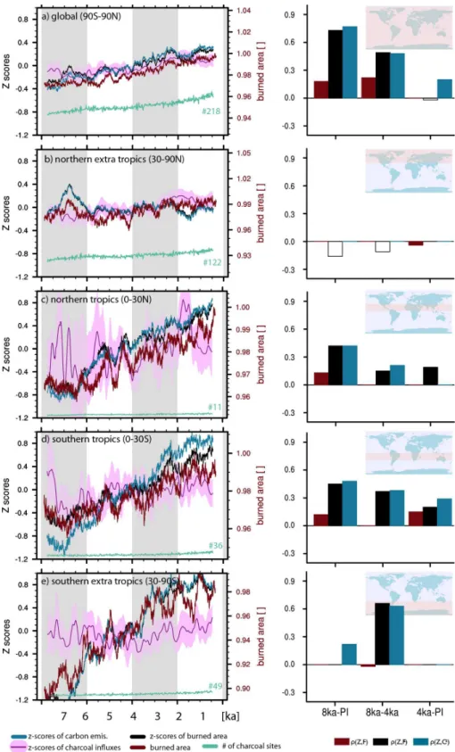
3.2.1 Comparison on hemispheric scale
To compare the modelled and reconstructed numbers of ag-gregated Z-score values on a hemispheric scale, we inves-tigate five spatial domains separately: global [90◦S–90◦N] (Fig. 3a), northern extra tropics [90–30◦N] (Fig. 3b), north-ern tropics [30–0◦N] (Fig. 3c), southern tropics [0–30◦S] (Fig. 3d), and southern extra tropics [30–90◦S] (Fig. 3e). These domains are chosen in analogue to Daniau et al. (2012). Shown areZ-score transformed time series of recon-structed (charcoal influx,Z) and modelled (burned areaFZ
Fig. 3.Averaged values for reconstructed and modelled biomass burning during the present interglacial as global values(a), for extra
tropics(b, e), and tropics(c, d)separately. Reconstructions are shown byZ-scores of charcoal influxes (Z, pink), andZ-score transformed
values of modelled burned area (FZ, black) and carbon emissions by fire (CZ, blue). Untransformed model output of burned area (F,
red) and the number of sites used in the reconstructions (green) are also given. For all time series a running mean of 250 yr is applied.
Please note the varying, relative scale of modelled burned area. The scale for the modelledZ-scores of burned area is determined by the
maximum amplitude ofZ-score transformed charcoal influxes (reconstructions). On the right side, the corresponding rank correlationsρ
not shown, as on regional to hemispheric scaleF andC are almost linearly correlated (not shown here). Charcoal data are given as the median and the±95th percentile of a boot-strap analysis (see Sect. 2.1). A large spread between median and the±95th percentile highlights a low number of records in the database or a heterogeneous domain (e.g. Fig. 3c). For three different time periods (8000 cal yr BP–PI, 8000– 4000 cal yr BP, 4000 cal yr BP–PI) the rank correlation after Spearman (1908) is used as an objective measure to quan-tify the agreement between modelled and reconstructed val-ues. The numbers are given for the correlations between (i)Z
andF (ρ(Z, F )), (ii)Z andFZ(ρ(Z, FZ)), and (iii)Z and
CZ(ρ(Z, CZ)) as a bar chart next to the global or large-scale zonal averages.
On global scale (Fig. 3a) an increase within the burned area is observed (red line = burned area). With a base of 218 sites, the spread between the±95th percentiles and the median is rather low, suggesting that the global signal out of the reconstructions is rather robust. Modelled data do agree in the trend and magnitude (14 Mha, ca. 2.5 %). If the same fire model is used within an earth system model, findings by Krause et al. (2014) suggest values in the same order of magnitude (ca. 580 Mha burned area per year) by count-ing for present-day climate, pre-industrial land areas and no human ignition. However, if the fire model is used in a more realistic set-up for present-day climate (Kloster et al., 2010), a mean simulated burned area of 327 Mha yr−1stays at the lower band of satellite observations from 329 Mha yr−1 (GFED) to 401 Mha yr−1(L4JRC). Model results of carbon emissions vary between 2.0 to 2.4 Pg C yr−1 and are close to the numbers of satellite products (2.3 to 2.7 Pg C yr−1). While the rank correlation between the untransformed model data is small (ρ(Z, F )= 0.18), the numbers are much higher (ρ(Z, FZ)= 0.73 and ρ(Z, CZ)= 0.77) if the Z-scores of charcoal values are compared to Z-scores of modelled burned area. If the full period of 7800 yr is divided into two subsets (8000 to 4000 cal yr BP and 4000 cal yr BP to PI), the correlation is reduced, especially for the latter one, which suggests the overall Holocene trend is reproduced, but not the sub-millennial variability. The decrease in fire can be related to drier conditions on a global scale. While changes in temperature are relatively small (ca. 0.1 K, see Fig. S2a in the Supplement), decreases in yearly precipita-tion by ca. 40 mm yr−1 and the small increase in biomass (i.e. fuel availability) dominate the effect on driving fire ac-tivity. The continuous increase in the carbon stocks is also supported by CO2fertilization (12 ppm increase; Fig. S2a in the Supplement; Keenan et al., 2013).
For the northern extra tropics, the charcoal data show a small increase, while the modelled fire activity stays almost constant (Fig. 3b) at ca. 164 Mha. A rank correlation gives a negative correlation coefficient for theZ-scores of burned area and carbon emissions with the charcoal reconstructions, while the correlation of burned area and the charcoal recon-structions is not significant (Fig. 3b). On the large area mean,
the temperature decreases by 0.2 K, the climate gets drier (40 mm yr−1), and the biomass decreases. The shift toward reduced fuel availability and drier conditions seems to be compensated by drier conditions, which lead to almost no change in modelled burned area.
For the tropics (Fig. 3c and d) a strong increase in burned area is reported after 7000 cal yr BP in the charcoal database. The model results reflect this increase over the full period and all time series are positively correlated, ranging from
ρ(Z, FZ)= 0.42 to ρ(Z, CZ)= 0.48 (for further details see Table S1 in the Supplement). While the numbers ofZ-score transformed data suggest a strong change, the modelled num-bers vary only by 6 Mha from 8000 cal yr BP to PI (northern and southern tropics), which suggests a change by roughly 4 %. In the case of untransformed modelled data, the correla-tion shrinks by factor of three, which supports the standard-ization of model output to improve comparability with char-coal influx values. In terms of large-scale averages, climate is not changing significantly over the 7800 yr in the southern tropics, while precipitation decreases in the northern tropics by ca. 10 %. (80 mm yr−1). As precipitation is the controlling parameter for tropical vegetation, biomass decreases in the northern tropics and increases slightly in the southern trop-ics. As both areas point toward an increase in fire activity, it seems that on a large-scale fire in the tropics is primarily determined by fuel abundance and moisture availability.
For the southern extra tropics (Fig. 3e), the level of re-constructed natural fire activity stays almost constant with a small decrease around 4000 cal yr BP. However, the model results show a strong increase in burned area and car-bon emissions over the entire period of 7800 yr simu-lated. The rank correlation shows, that less than 15 % of variability is explained by the Z-score transformed data (ρ(Z, F Z)= 0.24; ρ(Z, CZ)= 0.22) and the absolute, not transformed values of burned area do not correlate signifi-cantly (p <0.05) with the reconstructions. An explanation for the disagreement could be the small land area in general and a large fraction of coastal area within this region (south-ern part of Africa, Patagonia, and partly Australia), which are in general difficult to represent in global climate models. Al-ternatively, the domain of southern extra tropics is the area with the highest simulated burned area (nearly 70 %). How-ever, the simulated drop in temperature (by 0.2 K) is rather small, but the decrease in precipitation, leading to drier con-ditions, appears more significant. In the model the increase in
Z-score values of burned area is likely linked to changes in precipitation. The modelled precipitation change does, how-ever, not necessarily reflect observed changes, which require further investigations.
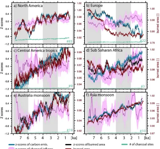
Fig. 4.Same as Fig. 3, but for continental scale regions North America(a), Europe(b), Central America tropics(c), Sub Saharan Africa(d),
Australian monsoon region(e), and Asia monsoon region(f). The definition of the domains is taken from Marlon et al. (2013). For the rankc
or relations see Fig. 5.
4000 cal yr BP and 4000 cal BP to 200 cal yr BP) separately, the correlation decreases or even becomes negative, which suggests that the general trend of increasing burned area over the entire period (8000 cal yr BP until 200 cal yr BP) is partly reproduced and responsible for the correlation coeffi-cient over the 7800 yr.
To test the robustness of these modelled trends, we cre-ated a four-member ensemble based on identical initial con-ditions. Due to the randomness inherent in the base climate (see Sect. 2.1) all simulations develop independently. The analysis of the ensemble shows that the simulated trends in fire occurrence are all similar, indicating that our results are robust (Fig. S2 in the Supplement).
3.2.2 Comparison on regional scale
To investigate the model performance on more homogeneous regions, the methodology used in the previous Sect. 3.2.1 is applied on regional scale, following domains defined and dis-cussed in Marlon et al. (2013) (Figs. 4 and 5). Most of the charcoalZ-score time series point to an increase in fire ac-tivity, except for the Central America tropics (Fig. 4c), where
a u-shaped pattern ofZ-score influxes comes across with a high centennial variability including a high uncertainty pos-sibly caused by a low number of charcoal records available (n= 9). The Asia monsoon region (Fig. 4f) also has a limited number of charcoal records (n= 10).
On a first glance, JSBACH simulates an increase in burned area and carbon emissions in all regions except Europe (Fig. 4b), where burned area decreases between 6000 and 4000 cal yr BP by 25 % and remains afterwards at ca. 18 Mha (Fig. S4b in the Supplement). In addition, for all regions, the modelled timing of local minima or maxima does not match the reconstructions. The rank correlation on these time se-ries indicates overall agreement that there was an increase in fire activity, with positive correlation coefficients between
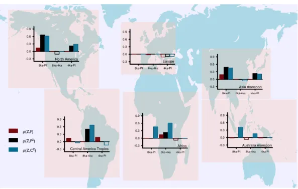
ρ(Z,F)
ρ(Z,Cz) ρ(Z,Fz)
Fig. 5.Regional rank correlationsρ(after Spearman) are shown (compare Fig. 4). Significant, positive values are given by filled bars for
three different time windows: 8 ka–IP, 8–4ka, and 4 ka–PI. The underlying, aggregated time series are shown in Fig. 4.
4000 cal yr BP and 4000 cal yr BP to PI), results in a de-crease in explained variance, and partly negative correlations (Fig. 5). Only the African region (Figs. 4d and 5) differs from this general pattern; as the correlation coefficient between the
Z-scores of modelled carbon emissions and charcoal influxes increases over time; it has a lower value for the entire pe-riod (ρ8k-PI= 0.46;p <0.001) a higher value during the first half (ρ8K-4K= 0.61;p <0.001), but is negative for the second time interval. Another interesting aspect of the African palae-ofire simulation is the slight decrease in burned area (and car-bon emissions) with time over the entire period, although an increase is notable for theZ-score transformed values of car-bon emissions and burned area. As aZ-score transformation removes the absolute value of a variable, averaging theZ -score time series of several grid cells can change the sign of the trend. As an example, two neighbouring grid boxes with one showing an increase by 50 % and the other showing a de-crease by 50 % of fire activity can result in aZ-score of zero, as both trends cancel each other. If the boxes, however, differ in their burned area magnitude (with respect to square metre burned area), the absolute change would be different from 0. Another unique result for Africa (Fig. 4d) is the inter-play between burned area and carbon emissions. The corre-lation coefficient betweenZ-scores of modelled burned area and modelled carbon emissions isρ= 0.98 (p <0.001; Ta-ble S1 in the Supplement) at a minimum for all but one re-gion (Figs. 3 and 4). Only the analysis of the African domain stands out with a lower value ofρ= 0.84 (p <0.001).
By considering significant and positive rank correlations, we find for all regions – except for the Central America tropics (Fig. 4c) – a higher rank correlation between Z -score transformed data and reconstructions (ρ(Z, FZ) and
ρ(Z, CZ)), than for untransformed model data and recon-structions (ρ(Z, F)). Given the current study design and model configuration, the main driver of changes in Holocene climate (last 8000 yr) is orbital forcing; changes due to in-creasing CO2 are of secondary order. Human impact in the experimental set-up is neglected. Furthermore, this study fo-cuses on large, heterogeneous regions and differences in the results based on (Z, CZ) vs. (Z, FZ) are therefore minor. Looking at the ensemble results (Fig. S4 in the Supplement), it is apparent, that the trends simulated by each ensemble member are rather close to each other and differences be-tween the model results and reconstructions are systematic.
4 Conclusions
Over the past 8000 yr we simulate an increase of ca. 14 Mha (from 512 to 526 Mha) in burned area. The ab-solute numbers of burned area are high, however, consid-ering that the human dimensions in terms of fire ignitions and fire suppression are neglected. In addition, the model accounts for fire activity given only potential natural vege-tation (i.e. with no land use and land use cover change in-cluded). The increase itself and the variability on millen-nial timescales varies between and among regions. When the modelled time series are transformed toZ-scores and com-pared to reconstructed charcoal Z-scores, model and data agree for most of the regions. Thus, to address the question “How well can fire models reproduce fire activity?”, we can state that our model simulates most of the trends in the recon-structions on millennial scales. Further investigations would be necessary to test whether the model performs well for the right reasons.
One limiting component of our model set-up is the choice of an EMIC as the climate driver. Especially on regional scales, our fire model results are limited by the quality of the climate forcing, which can (partly) explain our limited abil-ity to reproduce centennial or millennial variations. Another regional model study by Molinari et al. (2013) compared charcoal records in Europe with an earth system model that simulated dynamic vegetation using LPJ-GUESS and two independent land-cover scenarios. The climate simulations and analysis of land cover change suggests biomass burn-ing across Europe was primarily explained by vegetation, precipitation and temperature-related parameters during the early Holocene. Charcoal-based observations of increased fire activity during the mid–late Holocene were primarily driven by changes in anthropogenic land-cover, and secon-darily by changes in vegetation and temperature (Molinari et al., 2013). As our study does not count for anthropogenic changes, we can conclude that we can conclude that the most parsimonious explanation suggest inaccuracies in our simu-lated climate is the most likely source of discrepancies be-tween model and data.
For most of the investigated regions the model simulates an increase in burned area and carbon emissions. The trends in the carbon emissions were higher than trends detected in burned area. We propose several reasons for this obser-vation: (i) CO2fertilization by the increasing concentration of atmospheric CO2increases the emissions per square me-tre burned area due to a higher carbon stock in the vege-tation. (ii) The carbon stock of the fuel can increase with shifts in vegetation types due to changes in the climate, or fire occurrence may be altered because of climate changes. A rank correlation analysis points to the overall agreement be-tween simulated and observed trends in fire activity over the whole period of study, while a rank correlation on time seg-ments shows that the model does not match the centennial-or millennial-scale variability. Agreement on variability on these timescales is not expected, as regional climate affects local fire activity, and there is no reason why the timing of the
modelled climate variability should coincide with the climate of the past. The differences and similarities between recon-structions and model results are stable. The analysis of a four-member ensemble shows rather small differences between the individual simulations and a consistent trend given by the ensemble members (Figs. S4 and S5 in the Supplement).
From a modelling perspective, this study helps to validate the capability of a model to simulate past fire activity. In addition, given that the fire model is not tuned by the char-coal data, the overall agreement (on hemispheric and regional scales) illustrates the ability to reconstruct broad changes in palaeofire activity from syntheses of palaeofire records in the Global Charcoal Database. Even regions which are sparsely covered by reconstructions correlate positively with the model results, pointing to the importance and increased confidence of using both data and models together to provide more complete spatial coverage of past fire activity.
Z-score transformed data do not provide information about quantitative changes in burned area, because the trans-formation is rank conserving but not linear. So, a given dif-ference inZ-score values [ ] does not imply an increase or decrease by the same magnitude in burned area [Mha] among differentZ-scores. This suggests regional averages of trans-formed and untranstrans-formed data may not necessarily result in the same trends. Thus, with respect to the research ques-tion “What is the best way to compare fire model output with charcoal records?”, we conclude that it is more meaningful to convert the time series of modelled burned area or carbon emissions toZ-score for comparing modelled and observed palaeofire variability. While we do see some general agree-ment between model results and reconstructions, it is still un-clear whether the absolute values of simulated burned area are capturing the right magnitude for past fire activity. While high fluctuations could suggest huge changes (e.g. Fig. 4e), the absolute change is rather small (2 Mha, ca. 7 %). Future studies should consider methods of transforming model out-put variables and palaeo-proxy data consistently to increase the comparability of simulated and observed data. In this study theZ-score transformation helps to validate modelled natural fire occurrence and compare it to reconstructed val-ues of charcoal influxes reported asZ-scores.
Supplementary material related to this article is
available online at http://www.clim-past.net/10/811/2014/ cp-10-811-2014-supplement.pdf.
Acknowledgements. We thank data contributors to the Global
project from the European Commission’s 7th Framework Pro-gramme, grant number 243908, and is Past4Future contribution number 59.
The service charges for this open access publication have been covered by the Max Planck Society.
Edited by: C. Barbante
References
Arora, V. K. and Boer, G. J.: Fire as an interactive component of dynamic vegetation models, J. Geophys. Res, 110, G02008, doi:10.1029/2005JG000042, 2005.
Arora, V. K., Boer, G. J., Friedlingstein, P., Eby, M., Jones, C. D., Christian, J. R., Bonan, G., Bopp, L., Brovkin, V., Cad-ule, P., Hajima, T., Ilyina, T., Lindsay, K., Tjiputra, J. F., and Wu, T: Carbon–Concentration and Carbon–Climate Feedbacks in CMIP5 Earth System Models, J. Climate, 26, 5289–5314, doi:10.1175/JCLI-D-12-00494.1, 2013.
Berger, A.: Long-term variations of daily insolation and Quaternary climatic changes, J. Atmos. Sci., 35, 2362–2367, 1978. Berger, A., Loutre, M. F., and Gallée, H.: Sensitivity of the LLN
climate model to the astronomical and CO2forcings over the last
200 ky, Clim. Dynam., 14, 615–629, 1998.
Braconnot, P., Otto-Bliesner, B., Harrison, S., Joussaume, S., Pe-terchmitt, J.-Y., Abe-Ouchi, A., Crucifix, M., Driesschaert, E., Fichefet, Th., Hewitt, C. D., Kageyama, M., Kitoh, A., Laîné, A., Loutre, M.-F., Marti, O., Merkel, U., Ramstein, G., Valdes, P., Weber, S. L., Yu, Y., and Zhao, Y.: Results of PMIP2 coupled simulations of the Mid-Holocene and Last Glacial Maximum – Part 1: experiments and large-scale features, Clim. Past, 3, 261– 277, doi:10.5194/cp-3-261-2007, 2007.
Brovkin, V., Bendtsen, J., Claussen, M., Ganopolski, A., Ku-batzki, C., Petoukhov, V., and Andreev, A.: Carbon cycle, veg-etation, and climate dynamics in the Holocene: experiments with the CLIMBER-2 model, Global Biogeochem. Cy., 16, 86-1–86-20, doi:10.1029/2001GB001662, 2002.
Brovkin, V., Raddatz, T., Reick, C., Claussen, M., and Gayler, V.: Global biogeophysical interactions between forest and climate, Geophys. Res. Lett, 36, L07405, doi:10.1029/2009GL037543, 2009.
Claussen, M.: Modeling bio-geophysical feedback in the African and Indian monsoon region, Clim. Dynam., 13, 247–257, 1997. Daniau, A.-L., Bartlein, P. J., Harrison, S. P., Prentice, I. C.,
Brewer, S., Friedlingstein, P., Harrison-Prentice, T. I., Inoue, J., Izumi, K., Marlon, J. R., Mooney, S., Power, M. J., Stevenson, J., Tinner, W., Andriˇc, M., Atanassova, J., Behling, H., Black, M., Blarquez, O., Brown, K. J., Carcaillet, C., Colhoun, E. A., Colombaroli, D., Davis, B. A. S., D’Costa, D., Dodson, J., Dupont, L., Eshetu, Z., Gavin, D. G., Genries, A., Haberle, S., Hallett, D. J., Hope, G., Horn, S. P., Kassa, T. G., Katamura, F., Kennedy, L. M., Kershaw, P., Krivonogov, S., Long, C., Ma-gri, D., Marinova, E., McKenzie, G. M., Moreno, P. I., Moss, P., Neumann, F. H., Norström, E., Paitre, C., Rius, D., Roberts, N., Robinson, G. S., Sasaki, N., Scott, L., Takahara, H., Ter-williger, V., Thevenon, F., Turner, R., Valsecchi, V. G., Van-niére, B., Walsh, M., Williams, N., and Zhang, Y.: Predictability
of biomass burning in response to climate changes, Global Bio-geochem. Cy., 26, GB4007, doi:10.1029/2011GB004249, 2012. Elsig, J., Schmitt, J., Leuenberger, D., Schneider, R., Eyer, M., Leuenberger, M., Joos, F., Fischer, H., and Stocker, T. F.: Sta-ble isotope constraints on Holocene carbon cycle changes from an Antarctic ice core, Nature, 461, 507–510, 2009.
Fang, K., Morris, J. L., Salonen, J. S., Miller, P. A., Renssen, H., Sykes, M. T., and Seppä, H.: How robust are Holocene treeline simulations? A model–data comparison in the European Arctic treeline region, J. Quaternary Sci., 28, 595–604, 2013.
Feurdean, A., Liakka, J., Vanniére, B., Marinova, E., Hutchinson, S. M., Mosburgger, V., and Hickler, T.: 12,000-Years of fire regime drivers in the lowlands of Transylvania (Central-Eastern Europe): a data-model approach, Quaternary Sci. Rev., 81, 48–61, 2013. Fischer, N. and Jungclaus, J. H.: Effects of orbital forcing on
at-mosphere and ocean heat transports in Holocene and Eemian climate simulations with a comprehensive Earth system model, Clim. Past, 6, 155–168, doi:10.5194/cp-6-155-2010, 2010. Gaillard, M.-J., Sugita, S., Mazier, F., Trondman, A.-K., Broström,
A., Hickler, T., Kaplan, J. O., Kjellström, E., Kokfelt, U., Kuneš, P., Lemmen, C., Miller, P., Olofsson, J., Poska, A., Rundgren, M., Smith, B., Strandberg, G., Fyfe, R., Nielsen, A. B., Ale-nius, T., Balakauskas, L., Barnekow, L., Birks, H. J. B., Bjune, A., Björkman, L., Giesecke, T., Hjelle, K., Kalnina, L., Kan-gur, M., van der Knaap, W. O., Koff, T., Lagerås, P., Latałowa, M., Leydet, M., Lechterbeck, J., Lindbladh, M., Odgaard, B., Peglar, S., Segerström, U., von Stedingk, H., and Seppä, H.: Holocene land-cover reconstructions for studies on land cover-climate feedbacks, Clim. Past, 6, 483–499, doi:10.5194/cp-6-483-2010, 2010.
Ganopolski, A., Petoukhov, V., Rahmstorf, S., Brovkin, V., Claussen, M., Eliseev, A., and Kubatzki, C.: CLIMBER-2: a cli-mate system model of intermediate complexity, Part II: Model sensitivity, Clim. Dynam., 17, 735–751, 2001.
Giorgetta, M. A., Jungclaus, J., Reick, C. H., Legutke, S., Bader, J., Böttinger, M., Brovkin, V., Crueger, T., Esch, M., Fieg, K., Glushak, K., Gayler, V., Haak, H., Hollweg, H.-D., Ilyina, T., Kinne, S., Kornblueh, L., Matei, D., Mauritsen, T., Mikolajew-icz, U., Mueller, W., Notz, D., Pithan, F., Raddatz, T., Rast, S., Redler, R., Roeckner, E., Schmidt, H., Schnur, R., Segschnei-der, J., Six, K. D., Stockhause, M., Timmreck, C., Wegner, J., Widmann, He., Wieners, K.-H., Claussen, M., Marotzke, J., and Stevens, B.: Climate and carbon cycle changes from 1850 to 2100 in MPI-ESM simulations for the Coupled Model Intercom-parison Project phase 5, J. Adv. Model. Earth Syst., 5, 572–597, doi:10.1002/jame.20038, 2013.
Goldewijk, K. K.: Estimating global land use change over the past 300 years: the HYDE database, Global Biogeochem. Cy., 15, 417–433, 2001.
Keenan, T. F., Hollinger, D. Y., Bohrer, G., Dragoni, D., Munger, J. W., Schmid, H. P., and Richardson, A. D.: Increase in forest water-use efficiency as atmospheric carbon dioxide con-centrations rise, Nature, 499, 324–327, 2013.
Kleinen, T., Tarasov, P., Brovkin, V., Andreev, A., and Stebich, M.: Comparison of modeled and reconstructed changes in for-est cover through the past 8 000 years: Eurasian perspective, Holocene, 21, 723–734, 2011.
Kloster, S., Mahowald, N. M., Randerson, J. T., Thornton, P. E., Hoffman, F. M., Levis, S., Lawrence, P. J., Feddema, J. J., Ole-son, K. W., and Lawrence, D. M.: Fire dynamics during the 20th century simulated by the Community Land Model, Biogeo-sciences, 7, 1877–1902, doi:10.5194/bg-7-1877-2010, 2010. Krause, A., Kloster, S., Wilkenskjeld, S., and Paeth, H.: The
sensi-tivity of global wildfires to simulated past, present, and future lightning frequency, J. Geophys. Res.-Biogeo., 119, 312–322, doi:10.1002/2013JG002502, 2014.
Kutzbach, J. E. and Liu, Z.: Response of the African monsoon to orbital forcing and ocean feedbacks in the middle Holocene, Sci-ence, 278, 440–443, 1997.
Lorenz, S. J., Kim, J.-H., Rimbu, N., Schneider, R. R., and Lohmann, G.: Orbitally driven insolation forcing on Holocene climate trends: evidence from alkenone data
and climate modeling, Paleoceanography, 21, PA1002,
doi:10.1029/2005PA001152, 2006.
Marcott, S. A., Shakun, J. D., Clark, P. U., and Mix, A. C.: A reconstruction of regional and global temperature for the past 11 300 years, Science, 339, 1198–1201, 2013.
Marlon, J. R., Bartlein, P. J., Walsh, M. K., Harrison, S. P., Brown, K. J., Edwards, M. E., Higuera, P. E., Power, M. J., An-derson, R. S., and Briles, C.: Wildfire responses to abrupt climate change in North America, P. Natl. Acad. Sci. USA, 106, 2519– 2524, 2009.
Marlon, J. R., Bartlein, P. J., Daniau, A.-L., Harrison, S. P., Maezumi, S. Y., Power, M. J., Tinner, W., and Vanniére, B.: Global biomass burning: a synthesis and review of Holocene pa-leofire records and their controls, Quaternary Sci. Rev., 65, 5–25, 2013.
Masson-Delmotte, V., Schulz, M., Abe-Ouchi, A., Beer, J., Ganopolski, A., González Rouco, J. F., Jansen, E., Lam-beck, K., Luterbacher, J., Naish, T., Osborn, T., Otto-Bliesner, B., Quinn, T., Ramesh, R., Rojas, M., Shao, X., and Timmer-mann, A.: Information from Paleoclimate Archives, in: Cli-mate Change 2013: The Physical Science Basis. Contribution of Working Group I to the Fifth Assessment Report of the Intergov-ernmental Panel on Climate Change, edited by: Stocker, T. F., Qin, D., Plattner, G.-K., Tignor, M., Allen, S. K., Boschung, J., Nauels, A., Xia, Y., Bex V., and Midgley, P. M., Cambridge Uni-versity Press, Cambridge, UK and New York, NY, USA, 2013. Molinari, C., Lehsten, V., Bradshaw, R., Power, M. J., Harmand,
P., Arneth, A., Kaplan, J., Vanniére, B., and Sykes, M. T.: Ex-ploring potential drivers of European biomass burning over the Holocene: a data-model analysis, Global Ecol. Biogeogr., 22, 1248–1260, doi:10.1111/geb.12090, 2013.
Monnin, E., Steig, E. J., Siegenthaler, U., Kawamura, K., Schwan-der, J., Stauffer, B., Stocker, T. F., Morse, D. L., Barnola, J.-M., Bellier, B., Raynaud, D., and Fischer, H.: Evidence for sub-stantial accumulation rate variability in Antarctica during the
Holocene, through synchronization of CO2in the Taylor Dome,
Dome C and DML ice cores, Earth Planet. Sc. Lett., 224, 45–54, 2004.
Petoukhov, V., Ganopolski, A., Brovkin, V., Claussen, M., Eliseev, A., Kubatzki, C., and Rahmstorf, S.: CLIMBER-2: a cli-mate system model of intermediate complexity, Part I: Model de-scription and performance for present climate, Clim. Dynam., 16, 1–17, 2000.
Pfeiffer, M., Spessa, A., and Kaplan, J. O.: A model for global biomass burning in preindustrial time: LPJ-LMfire (v1.0), Geosci. Model Dev., 6, 643–685, doi:10.5194/gmd-6-643-2013, 2013.
Pongratz, J., Reick, C. H., Raddatz, T., and Claussen, M.: Ef-fects of anthropogenic land cover change on the carbon cycle of the last millennium, Global Biogeochem. Cy., 23, GB4001, doi:10.1029/2009GB003488, 2009.
Power, M., Marlon, J., Ortiz, N., Bartlein, P., Harrison, S., Mayle, F., Ballouche, A., Bradshaw, R., Carcaillet, C., and Cordova, C.: Changes in fire regimes since the Last Glacial Maximum: an as-sessment based on a global synthesis and analysis of charcoal data, Clim. Dynam., 30, 887–907, 2008.
Prentice, I. C., Cramer, W., Harrison, S. P., Leemans, R., Mon-serud, R. A., and Solomon, A. M.: Special paper: a global biome model based on plant physiology and dominance, soil properties and climate, J. Biogeogr., 117–134, 1992.
Raddatz, T. J., Reick, C. H., Knorr, W., Kattge, J., Roeckner, E., Schnur, R., Schnitzler, K.-G., Wetzel, P., and Jungclaus, J.: Will the tropical land biosphere dominate the climate–carbon cycle feedback during the twenty-first century?, Clim. Dynam., 29, 565–574, 2007.
Reick, C. H., Raddatz, T., Brovkin, V., and Gayler, V.: Representation of natural and anthropogenic land cover change in MPI-ESM, J. Adv. Model. Earth Syst., 5, 1–24, doi:10.1002/jame.20022, 2013.
Renssen, H., Goosse, H., Fichefet, T., Brovkin, V., Driesschaert, E., and Wolk, F.: Simulating the Holocene climate evolution at northern high latitudes using a coupled atmosphere-sea ice-ocean-vegetation model, Clim. Dynam., 24, 23–43, 2004. Renssen, H., Seppä, H., Heiri, O., Roche, D., Goosse, H., and
Fichefet, T.: The spatial and temporal complexity of the Holocene thermal maximum, Nat. Geosci., 2, 411–414, 2009. Ruddiman, W. F.: The anthropogenic greenhouse era began
thou-sands of years ago, Climatic Change, 61, 261–293, 2003. Schneck, R., Reick, C. H., and Raddatz, T.: Land contribution
to natural CO2variability on time scales of centuries, J. Adv.
Model. Earth Syst., 5, 354–365, 2013.
Sitch, S., Smith, B., Prentice, I. C., Arneth, A., Bondeau, A., Cramer, W., Kaplan, J. O., Levis, S., Lucht, W., and Sykes, M. T.: Evaluation of ecosystem dynamics, plant geography and terres-trial carbon cycling in the LPJ dynamic global vegetation model, Global Change Biol., 9, 161–185, 2003.
Spearman, C.: The method of “right and wrong cases” (“constant stimuli”) without Gauss’s formulae, 1904–1920, Brit. J. Psy-chol., 2, 227–242, 1908.
Thonicke, K., Spessa, A., Prentice, I. C., Harrison, S. P., Dong, L., and Carmona-Moreno, C.: The influence of vegetation, fire spread and fire behaviour on biomass burning and trace gas emis-sions: results from a process-based model, Biogeosciences, 7, 1991–2011, doi:10.5194/bg-7-1991-2010, 2010.
Venables, W. N. and Ripley, B. D.: Modern Applied Statistics with S-PLUS, 4th Edn., Springer, New York, 465–480, 1994. Wanner, H., Beer, J., Bütikofer, J., Crowley, T. J., Cubasch, U.,
Flückiger, J., Goosse, H., Grosjean, M., Joos, F., Kaplan, J. O., Küttel, M., Müller, S. A., Prentice, I. C., Solomina, O., Stocker, T. F., Tarasov, P., Wagner, M., and Widmann, M.: Mid-to Late Holocene climate change: an overview, Quaternary Sci. Rev., 27, 1791–1828, 2008.
![Fig. 1. Yearly burned fraction of grid cell area [m 2 m −2 ] of natural fire activity (a) and carbon emissions [g C m −2 yr −1 ] (c) for the mid- mid-Holocene (8 ka = 8000 cal yr BP) and their anomalies (b, d) to burned fraction with pre-industrial (PI = 2](https://thumb-eu.123doks.com/thumbv2/123dok_br/18399316.358495/5.892.113.783.97.439/yearly-fraction-activity-emissions-holocene-anomalies-fraction-industrial.webp)
![Fig. 2. Transient anomalies of latitudinal averaged values (over land) for (a) yearly precipitation [mm yr −1 ], (b) desert fraction [m 2 m −2 ], (c) carbon stored in green biomass [kg C m −2 ], and (d) fraction of burned area [m 2 m −2 ]](https://thumb-eu.123doks.com/thumbv2/123dok_br/18399316.358495/6.892.193.699.94.552/transient-anomalies-latitudinal-averaged-precipitation-fraction-biomass-fraction.webp)