ABSTRACT
Using the average directions of the main wave-fronts which approach the coast of Bahia State – coinciding with that of the main wind occurring in the area – and of their periods, we define a wave climate model based on the construction of refraction diagrams. The resulting model of sediment transport was able to reproduce, in a general way, the sediment dispersion patterns furnished by geomorphic indicators of the littoral drift. These dispersion patterns control the generation of different types of sediment accumulations and of coastal stretches under erosion. We demonstrate that the presence of the Abrolhos and Corumbaú Point coral reefs is an important factor controlling the sediment dispersion patterns, since them act as a large protection against the waves action.
key words:Littoral drift, wave refraction, numerical modelling, State of Bahia, Brazil.
INTRODUCTION
The coast of the State of Bahia – Brazil (Fig.1) is entirely situated within the trade wind belt of the South Atlantic (NE - E - SE), which is related to the high-pressure cell occurring in this region. In fact, this system represents the major atmospheric circulation center along this extension of the South Atlantic ocean (Bigarella 1972, Martinet al. 1998). Another important element of the atmospheric cir-culation in this region is the periodic advance of the Atlantic Polar Front which takes place during the au-tumn and winter, and generates strong winds coming from SSE (Bigarella 1972, Martinet al. 1998). It is noteworthy the fact that, in an interannual scale, the high-pressure cell normally shows a tendency to
Correspondence to: Abílio Carlos da S.P. Bittencourt E-mail: abilioacpgg.ufba.br
remain relatively stationary. Seasonably, however, this cell tends to expand and contract. During the winter, the high-pressure zone covers a vast area of Brazil, while during the summer it returns to the ocean. On the coastal zone, this seasonal moviment of the high-pressure zone controls the position of the Divergence Zone (DZ), between the trade winds sensu stricto (SE) and the return trade winds (NE). During the winter, the DZ is located at
approxi-mately 20◦S while, during the summer time, the
position changes to approximately 13◦S (Bigarella
the Atlantic Polar Front, reinforce the trade winds from the SE. This general atmospheric circulation system is susceptible to disturbances, particularly on the occasion of severe events of the so-called phe-nomenon El Niño, which can disturb the advance of the Atlantic Polar Front.
The atmospheric circulation system briefly de-scribed above is responsible for the general pattern of wave-fronts reaching the coastline of the State of Bahia (Dominguezet al.1992; Martinet al.1998). Moreover, as it is discussed later, this circulation system is the major control of the sediment disper-sion pattern observed alongside the coast of Bahia. The aim of the present study is to define, ac-cording to a general model of wave climate acting upon the coast, the major patterns of sediment dis-persion alongside the littoral of the State of Bahia.
GEOLOGIC SETTING
The sediments occurring in the continental margin contiguous to the State of Bahia can be subdivided into large sequences, with ages ranging from the Late Jurassic to the Present Time (Changet al.1988, 1992). They are: (i) the continental sin-rift; (ii) evaporitic transitional; (iii) shallow carbonated platform; and (iv) the transgressive-regressive se-quences. During the Cenozoic Period, sedimen-tation in the continental margin was characterized by deltaic-fluvial sediments that graded offshore to-wards the shallow carbonated platform, and basin shales, organized in a typical progradational archi-tecture.
At the end of the Pliocene, sandy-clayey sedi-ments of alluvial origin, the so-called Barreiras For-mation accumulated alongside the coastal zone. Such deposition extended far away offshore in re-lation to the present day coastline. Remnants of this formation are still found in the continental shelf nowadays. It is suggested that the deposition of the Barreiras Formation occurred contemporaneously with a tilting of the continental margin (Ghignone
1979, Bittencourt et al. 1999). Nowadays, the
Barreiras Formation forms tablelands bordering the
coast of the State of Bahia (Figs. 2 and 8D). During the Quaternary Period, the coastal zone was affected by several transgressive-regressive episodes. During the last two episodes, the present sea level was exceeded at approximately 120,000 years B.P. (8±2m), and 5,100 years B.P. (5±1m) (Martin et al. 1979 1980 1982). Testimonies of these two episodes are found alongside the eastern Brazilian coast. This sea level history strongly con-trolled the evolution of the coastal zone, which is nowadays characterized by two groups of marine terraces covered by beach-ridges. These terraces are usually separated from each other by low lying zones corresponding to the old lagoons (Dominguez et al.1987 1992, Martin & Dominguez 1994).
PHYSIOGRAPHIC ASPECTS OF THE CONTINENTAL SHELF AND COAST OF THE STATE OF BAHIA
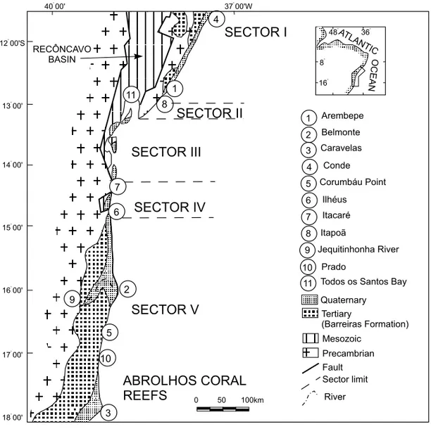
In the State of Bahia, the continental shelf can be subdivided into two well-defined stretches. In the first one north of Ilhéus, the continental shelf is quite narrow presenting a strong bathymetric gra-dient with the isobaths arranged approximately par-allel to each other, and also with relation to the coast-line. On the other hand, in the second stretch south of Ilhéus, the continental shelf widens, reaching an expressive width in front of Belmonte and Caravelas (Fig. 1). There, it presents a low bathymetric gradi-ent, and the isobaths exhibit quite irregular contours. As remarkable physiographic features in this region, it stands out the Royal Charlotte andAbrolhos banks, besides the coral reefs (Fig. 1).
From a physiographic viewpoint, the coastline of the State of Bahia can be divided into five sectors. They are described below starting from the north towards the south (Fig. 2).
Fig. 1 – Physiographic aspects of the continental shelf of the State of Bahia. Bathymetric contours in meters.
the case between the localities of Conde and Arem-bepe. There, the Quaternary sediments are better preserved in the valleys and reentrances excavated in the Barreiras Formation.
Sector II– This sector extends from the dis-trict of Itapoã up to the entrance of Todos os Santos Bay. It differs from the previous one because the Pre-cambrian basement outcrops on the coastline. Quaternary deposits are discontinuous, and poorly
developed.
become expressive.
Sector IV– This sector is limited by the locali-ties of Itacaré and Ilhéus. Similarly to the sector II, it is characterized by the presence of the Pre-cambrian basement either reaching the sea or quite close to it. Moreover, the Quaternary deposits are poorly devel-oped, except for the proximities of Ilhéus.
Sector V– This sector extends from Ilhéus up to the southern limit of the study area. It is charac-terized by the presence of the Barreiras Formation which, in some places, reaches the coastline form-ing active sea cliffs such as those occurrform-ing between Prado and the Corumbaú Point. The Quaternary coastal plain shows significant widths such as 25 km in the mouth of the Jequitinhonha River, and 17 km in the coastal plain of Caravelas. Also, this coastal stretch is characterized by the coral reefs of Abrolhos.
WAVE CLIMATE MODEL FOR THE COAST OF THE STATE OF BAHIA
Significant direct measurements of the wave regime alongside the coastline of the State of Bahia are not available. Nevertheless, using classical techniques (CERC 1984), standard wave refraction diagrams can be constructed resulting in a generic model of the wave climate for the study area (Figs. 3 and 4). The bathymetric data used in the construction of these diagrams were extracted from the nautical charts published by the Brazilian Navy, in a scale ap-proximately 1:300,000. Waves were not propagated in water depths shallower than 10m. The follow-ing wave-fronts directions were considered durfollow-ing construction of the refraction diagrams: NE(N45◦), E(N90◦), SE(N135◦), and SSE (N157.5◦) (Martin et al. 1998). Also, it was taken into account the following most significant periods and heights asso-ciated to them: the 5.0sec period and 1.0m height for the NE(N45◦) and E(N90◦) directions, and the
6.5sec period and 1.5m height for the SE(N135◦)
and SSE(N157.5◦) directions (U.S. Navy 1978).
The directions chosen represent the major wind di-rections occurring coastwise the State of Bahia, as
previously mentioned. It has been estimated that for the periods considered, the wave-fronts from the NE and E start interfering with the sea-bottom at a depth of approximately 20m, while for those com-ing from the SE and SSE, this interaction begins approximately at 35m. For most of Sector III, wave refraction diagrams were not constructed because of the following reasons: a) our scale of observation does not allow an appropriate representation of this stretch of coastline which is very segmented and b) the nautical charts do not depict important subma-rine features, such as river mouth bars and ebb tidal delta complexes which strongly influence wave re-fraction.
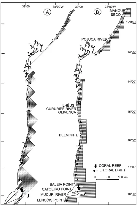
The wave-refraction diagrams show that the wave-fronts arising from the SE and SSE (Figs. 3A and B), refract more intensively than those coming from the NE and E (Figs. 4A and B). This can be verified by the larger number of coastal stretches showing divergence and convergence of wave-rays associated with SE-SSE waves. Thus, for exam-ple, it is remarkable the divergence of wave-rays in the coastal stretch between the Catoeiro Point and Itaquena, in relation to the SE waves (Fig. 3A), and between the Baleia Point and the St. Antonio Point, in relation to the SSE waves (Fig. 3B). Except-ing the region located south of the Baleia Point, the coastal stretches showing divergence of wave-rays, in relation to the waves from the NE are not too ex-pressive (Fig. 4A). The same is observed in relation to the waves from E (Fig. 4B). Regarding the coastal stretches showing significant convergence of wave-rays, these occur with the waves from the SSE and SE only. This is particularly remarkable between Itaquena and St. Antonio Point, with the SSE waves (Fig. 3B), and between Prado and the Corumbaú Point, with relation to the SE waves (Fig. 3A).
SEASONAL ORIENTATION OF THE LITTORAL DRIFT ALONGSIDE THE COAST OF THE STATE OF BAHIA
Fig. 2 – Simplified geological map of the study area showing the location of the different physiographic sectors discussed in the text.
(Figs.3 and 4).
Longshore drift directions could not be de-duced for a few sectors between the following localities: a) Catoeiro Point and Itaquena (waves from the SSE – Fig.3B); b) Catoeiro Point and Prado (waves from the SE – Fig. 3A); c) Mucuri River and the Baleia Point (waves from the E – Fig. 4B); and, d) Catoeiro Point and the extreme south of the study area (waves from the NE – Fig. 4A). These regions are normally characterized by low wave energy lev-els in comparison with the other coastal stretches analyzed in the present work. As a matter of fact, in general, these coastal stretches are regions of wave-shadows and significant wave-ray divergence, therefore, becoming places of enormous dispersion
of wave energy (King 1972, Komar 1976). There-fore, these regions show low levels of wave energy (Bascom 1954, Goldsmith 1976). Thus, taking into account the regional approach of our analysis, the littoral drift occurring in these regions can be con-sidered negligible. Similarly, alongside the coastal stretch between the mouth of the Pojuca River and Salvador, it has not been possible to determine any longshore drift orientation with relation to the NE waves, because the refracted wave rays do not reach the shoreline (Fig. 4A).
DISCUSSION AND CONCLUSIONS
Fig. 3 – Refraction diagram for waves with a 6.5 sec period, arising from the SE (N135◦) (A) and SSE (N157.5◦) (B), referred to the coastal stretch of the State of Bahia.
waves is directly proportional to the square of their heights (Davies 1972). Since the intensity of the lit-toral drift is proportional to the angle with which the wave-front strikes the shoreline (Zenkovitch 1967, Komar 1976, Kokot 1997), such factor was also con-sidered according to the function y = senα×cos
α (Komar 1976). Thus, the potential intensity of
the littoral drift of sediments, calculated per unit area, and expressed by a non-dimensional value, was
Fig. 4 – Refraction diagram for waves with 5 sec period, arising from NE (N45◦) (A) and E (N90◦) (B), referred to the coastal stretch of the State of Bahia.
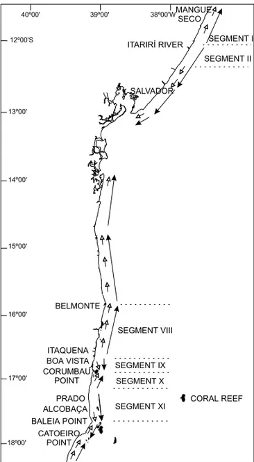
from both sources of data (Fig. 1), and the coastal stretches located above and below Ilhéus assumed to share the same wind regime occurring in Salvador and Caravelas, respectively. The coast of the State of Bahia was divided into 14 segments. Each of these segments was approximated to a straight line according to the orientation of its coastline. Then, the angles that the direction of the different deep water wave-fronts form with each of the segments were directly measured on the charts (Fig. 5).
A few limitations in the accuracy of the
of the measurements. This becomes clear in some places where the wave-fronts after being refracted, reach the coastline showing different directions than those originally presented offshore. This is mainly observed in the region south of Coruripe River (Figs. 3 and 4), and remarkably with relation to the waves arising from the SE and SSE (Figs. 3A and B). In fact, the use of such procedure was carried out under the circumstances imposed by the scale of observa-tion used in this work. This imposiobserva-tion required the littoral to be divided into large straight exten-sions masking the majority of the littoral’s sinuos-ity, therefore, considerably modifying the angles of incidence of the wave-fronts with the coastline. On the other hand, the use of the directions of the wave-fronts in deep water is justified as they represent approximate mean direction values.
In some of the different segments in which the coastline of Bahia was divided it was not noticed the incidence of any wave-front, either because these regions were located in wave-shadows or because the wave heights were considered negligible. These were the cases of the segment III, with relation to the waves from the NE (Fig. 5A, also see Fig. 4A), and the segments IX, X, and XI, with relation to the waves from the SSE (Fig. 5D, also see Fig. 3B). Moreover, it was not recorded any indication of drift in the segment III, with relation to the waves from the SE (Fig. 5C). However, this case was attributed to the fact that the angle of incidence of the waves in this region was equal to zero (See Fig. 3A).
The potential intensity values and directions obtained for the littoral drift alongside the coast of Bahia are shown on Tables I and II, along with the net littoral drift direction. This net littoral drift direction was estimated with and without the influence of the
(Farias et al., 1985; Martinet al. 1993, Bittencourt et al. 1997). In the coastal stretches showing sea-sonal opposite drift orientations, the net littoral drift was defined by assuming the predominant direction as given by the difference of the intensities of the opposite drifts. For instance, in the segment I, the summation of the drift intensities from the south to the north was 3455, while the value obtained for the summation of the intensities of the opposite drift di-rection, that is, from the north to the south was 1949 (Table I). Thus, the net drift direction resulting was from the south to the north, and with an intensity value of 1506, considering the SSE waves, and a value of 961 without the influence of these waves (Table I).
SEDIMENT
DISPERSION
CO
ASTWISE
B
AHIA-BRAZIL
280
Segments Origin of the Angle of Component of Intensity of the Littoral Percentage of the Annual Drift Intensity Intensity of the Dominant Intensity of the Dominant Drift
Wave-Front Incidence (α) the Drift Drift per Unit Area Annual Incidence of the Multiplied by Drift Minus the Secondary Minus the Secondary Drift (Net towards the senα. cosα.H2∗(×100) Waves the Percentage Drift (Net Littoral Drift) Littoral Drift) Without the North or South of the Annual With the Influence of the Influence of the Waves from the
Incidence Waves from the SSE SSE
NE (N 45◦) 60◦ N→S 43 18 774
I E (N 90◦) 15◦ N→S 25 47 1175 (1506) (961)
SE (N 135◦) 30◦ S→N 97 30 2910 S→N S→N
SSE (N 157,5◦) 52◦ S→N 109 5 545
NE (N 45◦) 81◦ N→S 15 18 270
II E (N 90◦) 36◦ N→S 47 47 2209 (934) (1429)
SE (N 135◦) 9◦ S→N 35 30 1050 N→S N→S
SSE (N 157,5◦) 31◦ S→N 99 5 495
NE (N 45◦) NI – – – –
III E (N 90◦) 44◦ N→S 50 47 2350 (1945) (2350)
SE (N 135◦) 0◦ – – – – N→S N→S
SSE (N 157,5◦) 23◦ S→N 81 5 405
NE (N 45◦) 56◦ N→S 46 18 828
IV E (N 90◦) 9◦ N→S 15 47 705 (2152) (1647)
SE (N 135◦) 35◦ S→N 106 30 3180 S→N S→N
SSE (N 157,5◦) 58◦ S→N 101 5 505
NE (N 45◦) 40◦ N→S 49 31 1519
V E (N 90◦) 7◦ S→N 12 35 420 (1978) (1211)
SE (N 135◦) 51◦ S→N 110 21 2310 S→N S→N
SSE (N 157,5◦) 74◦ S→N 59 13 767
NE (N 45◦) 46◦ N→S 50 31 1550
VI E (N 90◦) 0◦ – – 35 – (1816) (802)
SE (N 135◦) 45◦ S→N 112 21 2352 S→N S→N
SSE (N 157,5◦) 68◦ S→N 78 13 1014
NE (N 45◦) 40◦ N→S 49 31 1519
VII E (N 90◦) 7◦ S→N 12 35 420 (1978) (1211)
SE (N 135◦) 51◦ S→N 110 21 2310 S→N S→N
SSE (N 157,5◦) 74◦ S→N 59 13 767
NE (N 45◦) 58◦ N→S 45 31 1395
VIII E (N 90◦) 13◦ N→S 22 35 770 (1350) (2)
SE (N 135◦) 33◦ S→N 103 21 2163 S→N N→S
SSE (N 157,5◦) 56◦ S→N 104 13 1352
NE (N 45◦) 58◦ N→S 45 31 1395
IX E (N 90◦) 13◦ N→S 22 35 770 (2165) (2165)
SE (N 135◦) NI – – – – N→S N→S
SSE (N 157,5◦) NI – – – –
NE (N 45◦) NI – – – –
X E (N 90◦) 13◦ N→S 22 35 770 (1393) (1393)
SE (N 135◦) 33◦ S→N 103 21 2163 S→N S→N
SSE (N 157,5◦) NI – – – –
∗Normalized height of the wave in deep water per unit length; NE and E (1,0m), and SE and SSE (1,5m).
NI – No incidence of waves, or waves of negligible height (See Figures 3 and 4 for the wave-fronts arising from the SE/SSE and E/NE, respectively).
An.
Acad.
Br
as.
Ci.
,(2000)
72
B
AHIA-BRAZIL
281
SE (N 135◦) NI – – – – N→S N→S
SSE (N 157,5◦) 0◦ – – – –
NE (N 45◦) NI – – – –
XIII E (N 90◦) NI – – – – – –
SE (N 135◦) 0◦ – – – –
SSE (N 157,5◦) 0◦ – – – –
NE (N 45◦) NI – – –
XIV E (N 90◦) 28◦ N→S 41 35 1435 (1731) (236)
SE (N 135◦) 23◦ S→N 81 21 1701 S→N S→N
SSE (N 157,5◦) 45◦ S→N 112 13 1456
∗Normalized height of the wave in deep water per unit length; NE and E (1,0m), and SE and SSE (1,5m).
NI – No incidence of waves, or waves of negligible height (See Figures 3 and 4 for the wave-fronts arising from the SE/SSE and E/NE, respectively).
An.
Acad.
Br
as.
Ci.
,(2000)
72
Fig. 6 – Comparison of net littoral drift directions com-puted in this work for the State of Bahia (large arrows) with these provided by the available geomorphic indi-cators (small errors). Also shown are some of coastal segments discussed in the text.
the littoral drift induced by the NE waves.
According to the definition used herein for the net littoral drift direction, it can be ascertained that the segment VIII represents the only coastal stretch of Bahia to be susceptible to a decrease of wave-fronts from the SSE during the episodes involving the meteorological phenomenon El Niño (Table I, Fig. 5D). Despite the limitations previously men-tioned, the resultant model of sediment transport for the studied stretches of the coast of Bahia is
capa-ble to confirm those general patterns of sediment dispersion provided by the geomorphic indicators.
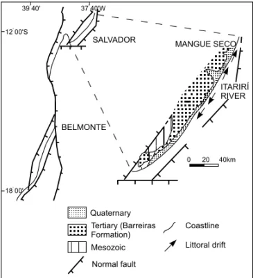
Besides the control by the atmospheric circu-lation system, the patterns of sediment dispersion alongside the coast of Bahia are also regulated by the general orientation of the coastline. In fact, the configuration assumed by the coastline of Bahia can be considered a legacy from the Mesozoic, when the South America and Africa split apart forming two separated continents (Bittencourtet al. 1999). As a result, alongside the coastal stretch from Salvador up to Mangue Seco, it is observed a remarkable par-allelism between the coastline and an existing fault line in the continental margin (Fig. 7). Similarly, from Belmonte towards the south, it is quite evident the southwestward deflection of the littoral, follow-ing the overall orientation shown by two faults sys-tems occurring in this region (Fig. 7). In the prox-imity of the mouth of the ItariríRiver, a little change in the coastline direction follows the northward de-flection of a fault line in the continental margin (Fig. 7). This fact is responsible for the divergence of the littoral drift direction occurring in this area (Fig. 6). Since in the coastal stretch southwest of the ItariríRiver’s mouth the waves from the SE arrive almost parallel to the shore (segment II, Fig. 5C), they generate a weak littoral drift in this area. As a result, the littoral drift produced by the waves com-ing from the E and NE, even though becom-ing shorter than those from the SE, provide a remarkable influ-ence on this region (segment II, Table I). On the other hand, in the coastal stretch located northeast of the ItariríRiver’s mouth, the littoral presents a very little deflection towards the north. This small deviation of the coastline, however, allows the waves arising from the southeast to form an expressive angle with the shore (segment I, Fig. 5C). Consequently, these waves perform a pivotal role in the delineation of the net littoral drift direction in this area (segment I, Table I).
pres-Fig. 7 - Simplified tectonic framework of the marginal basins of the State of Bahia (modified from Camposet al. 1974). The figure also shows a map based upon Campos
et al.(1974), and Martinet al.(1980).
ence of the coral reefs of the Abrolhos and the Co-rumbaú Point (Fig. 1). Clearly, these coral reefs pro-vide an important protection against the waves act-ing upon the coastal stretches facact-ing to them (Figs. 3 and 4) (Dominguez 1987). In fact, the presence of these coral reefs explains the dominance of a littoral drift induced by weak waves from the E and NE, in nearly the whole coastal extension between Itaquena and the Baleia Point. These drift reversals originate the two divergence zones of littoral drift occurring in this region (Fig. 6), and are a direct consequence of the protection provided by the reefs inhibiting the strong waves from the SE and SSE from reaching the shore (Figs. 3 and 6).
The patterns of sediment dispersion discussed above favored the formation of the different kinds of accumulation forms occurring alongside the coast of Bahia. Also, these patterns are responsible for the existence of large extensions of the shoreline under erosion. Amongst the several kinds of ac-cumulation forms, it stands out the cuspate
accu-structs the sediment flux coming from the south
(Dominguez 1987, Dominguez et al. 1987) (Fig.
6). Another significant accumulation form is rep-resented by the Mangue Seco spit, showing an ex-tension of approximately 15 km long (Figs. 6 and 8C). This accumulation form is located downdrift of an abrupt change in shoreline orientation, which inflects landward. This landward inflection of the shoreline causes a decrease in longshore transport rates, favoring sediment deposition and, therefore, allowing the formation of a spit, according to the mechanism discussed in Zenkovitch (1967).
Coastal stretches showing severe erosion are found between the Corumbaú Point and Prado, and just above Boa Vista, with extensions of approx-imately 40 km and 10 km long, respectively. In both sectors, active sea cliffs are present in the Bar-reiras Formation (Figs. 6 and 8D). The existence of these cliffs is correlated to the longshore drift divergences occurring in these regions, that are in fact, places where the sediment budget is negative (Fig. 6). In the proximity of the mouth of the ItariríRiver, another important longshore drift diver-gence is present. As a consequence, during the last 5.000 years the shoreline has prograded just a few tens of meters.
Because of the overall stability observed in the South Atlantic high-pressure cell, the trade winds generated in this cell are expected to show a remark-able persistence during the Quaternary (Dominguez et al. 1992). Consequently, these authors
Fig. 8 – (A) Cuspate accumulation form in the region of Caravelas (Also see figure 2). (B) Cuspate accumulation form in the region of Belmonte (Also see figure 2). (C) Mangue Seco spit (Also see figure 6). (D) Active sea cliffs in sediments of Barreiras Formation located on the north of Corumbáu Point (Also see figure 2).
alongside the Brazilian east-northeastern coast,
Dominguez et al. (1992) showed that in general,
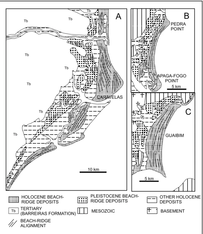
such patterns remained the same since the Pleis-tocene. Regarding the coast of the State of Bahia, significant examples are provided by the coastal plain regions of Caravelas (Fig. 9A), the Apaga-Fogo and Pedra points (Fig. 9B), and the Guaibim beach-ridge plain (Fig. 9C). In these regions, it can be clearly seen that the geometry of the
gen-Fig. 9 – Simplified geological maps of some coastal plains alongside the coast of the State of Bahia illustrating the persistence of the sediment dispersion and accumulation patterns during the Quaternary Period (modified from Martinet al.1980).
eral process of progradation. In the coastal plain of the Doce River (approximately 100 km south of the Caravelas coastal plain), the presence of similar beach-ridge truncations was correlated to periods of erosion resulting from the inversion of longshore
transport direction (Martin & Suguio, 1992). These inversions have been suggested by some authors to be a result of changes in atmospheric circulation
in-duced by El-Niño- like phenomena (Martinet al.
ACKNOWLEDGEMENTS
A.C.S.P. Bittencourt and J.M.L. Dominguez thank CNPq (Brazilian National Council of Research) for their fellowship. This research work was sponsored by the CNPq (Process no. 522948/96-0), and by the CNPq/IRD (Orstom), international convention, Project AIMPACT.
REFERENCES
Bascom WJ.1954. The control of stream outlets by wave
refraction.Jour Geol62:600-605.
Bigarella JJ.1972. Eolian environments - their
charac-teristics, recognition and importance. In:JK Rigby and WL Hamblineds.Recognition of Ancient
Sed-imentary Environments. SEPM, Spec Publ 16: p.
12-14.
Bittencourt ACSP, Dominguez JML & Ussami N.
1999. Flexure as a tectonic control on the large scale geomorphic characteristics of the eastern Brazil coastal zone.Journ Coastal Research15:505-519.
Bittencourt ACSP, Sampaio ES & Farias FF.1997.
Beach Imaging through the Time Evolution of To-pographical Profiles. Journ Coastal Research13: 1141-1149.
Campos CWM, Ponte FC & Miura K.1974. Geology of
the Brazilian Continental Margin. In:CA Burke e CL Drakeeds.The Geology of Continental Margins,
p. 447-461.
CERC(Coastal Engineering Research Center) 1984.
Shore Protection Manual. U.S. Army Corps of
En-gineers. Washington, D.C. V.I, 597 p.; V.II, 603p.
Chang HK, Kowsman RO & Figueiredo AMF.1988.
New concepts on the development of East Brazilian Marginal Basins.Episodes11:194-202.
Chang HK, Kowsman RO, Figueiredo AMF &
Ben-der AA.1992. Tectonics and stratigraphy of the
east Brazil Rift System: an overview.Tectonophysics 213:97-138.
Davies JL.1972.Geographical variation in coastal
de-velopment.Longman, Inc., New York, 204p.
DHN(Diretoria de Hidrografia e Navegação) 1993.Atlas
de Cartas-Piloto. Oceano Atlântico, de Trinidad ao
Rio da Prata, 13p.
Dominguez JML.1987. Quaternary sea-level changes
and the depositional architecture of beach-ridge
strandplains along the east coast of Brazil. Ph.D.
Dissertation, Univ. of Miami, 288p.
Dominguez JML, Bittencourt ACSP & Martin L.
1992. Controls on Quaternary coastal evolution of the east-northeastern coast of Brazil: roles of sea-level history, trade winds and climate.Sed Geol80: 213-232.
Dominguez JML, Martin L & Bittencourt ACSP.
1987. Sea-level history and the Quaternary evolution of river mouth-associated beach-ridge plains along the east-southeast coast of Brazil: a summary.In:D Mummedal, DH Pilkey and JD Howardeds.
Sea-Level Fluctuation and Coastal Evolution, SEPM, Spec Publ41:115-127.
Farias FF, Bittencourt ACSP, Zanini AJr &
Dominguez JML.1985. Variações temporais e
es-paciais na dinâmica de sedimentação da praia da Ar-mação, Salvador (BA).Rev Bras Geocienc15: 48-54.
Ghignone JI. 1979. Geologia dos sedimentos
fanero-zóicos do Estado da Bahia.In:H IndaEd.Geologia
e Recursos Minerais do Estado da Bahia– Textos
Básicos, SME/CPM, Salvador, Vol. 1: 24-117.
Goldsmith V. 1976. Continental shelf wave climate
models: a critical link between shelf hydraulics and shoreline processes. In: RA Davis Jred. Beach
and Nearshore Sedimentation, SEPM Spec Publ24:
39-69.
King CAM.1972.Beaches and Coasts.Edward Arnold,
London. 570p.
Kokot RR.1997. Littoral drift, evolution and
manage-ment in Punta Médanos, Argentina. Journ Coastal
Research13:192-197.
Komar PD.1976. Beach processes and sedimentation.
Prentice Hall, New Jersey, 429p.
Martin L & Dominguez JML.1994. Geological history
of coastal lagoons.In:B Kjerveed.Coastal Lagoon
Bahia, Brasil.
Martin L, Bittencourt ACSP & Vilas Boas GS.1982.
Primeira ocorrência de corais pleistocênicos da costa brasileira: datação do máximo da penúltima trans-gressão.Ciências da Terra1:16-17.
Martin L, Dominguez JML & Bittencourt ACSP.
1998. Climatic control of coastal erosion during a sea-level fall episode.An Acad Bras Ci70:249-266.
Martin L, Absy ML, Flexor JM, Fourier M,
Mour-guiart P, Sifeddine A & Turcq B.1993. Southern
Oscillation signal in South American paleoclimatic data of the last 7000 years.Quaternary Research33: 338-346.
US Navy1978. Marine Climatic Altas of the World,
Volume IV, South Atlantic Ocean. Washington D.C., 325p.
Zenkovitch VP.1967. Processes of Coastal