Instituto Politécnico de Tomar – Universidade de Trás-os-Montes e Alto Douro (Departamento de Geologia da UTAD – Departamento de Território, Arqueologia e Património do IPT)
Master Erasmus Mundus em QUATERNARIO E PRÉ-HISTÓRIA
Dissertação final:
Interpreting the Ritual Complex of N
A Study of a Megalithic Complex in Central Kerala, South India
Rachel A. Varghese
Orientador: Dr. George Nash
Júri:
Ano académico 2010- 2011
“A person does not belong to a place until there is someone of his own dead under the ground”
- Gabriel Garcia Marquez
CONTENTS
Acknowledgements i
Abstract iii
List of Figures iv
List of Tables vi
List of Abbreviations vii
Introduction 1
Chapter 1: The Context
The Physical and Geological Context The Temporal Span
The Sources 4 5 19 20 Chapter 2: Review
Monuments and People
Historiography of Early Kerala: Tools and perspectives
Text and Archaeology: Negotiating Multiple Source Categories
26 39 42 49 Chapter 3: Iron Age Burials of Central Kerala: An Overview
Typology
Megaliths of Central Kerala: Trends
54 55 58 Chapter 4: The Iron Age Burials of N
Previous Archaeological Research in the Region Methodology
N : Site Description
A Spatial Analysis of the Sites of N Macro Regional Analysis
N : The Sites within the Complex
Spatial Organisation within a Single Site: Case of ANK09VI
72 74 79 82 89 90 93 101 Conclusions 112 Bibliography 114 Appendix 1 124 Appendix 2 154 Appendix 3 155
i ACKNOWLEDGEMENTS
Working on this thesis was a valuable experience for me, in an academic and an equally important personal sense. This was in no way a work undertaken alone, but evolved out of the contribution of a number of individuals and institutions.
Dr. George Nash took a keen and critical interest at each stage of the work. While he was a demanding supervisor who helped maintain the academic rigour, he was also a concerned friend who helped me relax even at the most stressful stages of writing. Dr. Luis Oosterbeek was very supportive and gave important academic directions during the course of these two years. Dr. Rajan Gurukkal, M.G. University, Kerala allowed me access to the unpublished reports and material that I needed for the study. Discussions with him were valuable both at the stage of fieldwork and of writing. Important academic insights were provided by Dr. V.Selvakumar, Dr. Shajan Paul and Dr. Shinu Abraham.
I acknowledge the European commission for the financial assistance provided; Catarina Freire of IPT, Portugal who made all the complex administrative procedures smooth; each of the faculty members of the masters programme who helped me familiarize with the discipline of archaeology; the staff of the Museum of Mação for their support and concern during the stay in Mação; Dr. Martha Azarello, Cecilia and the staff of Ferrara for their support during the mobility period; Abby George for working on my maps; the faculty members of the Jawaharlal Nehru University (JNU), who helped me form my academic base and the staff of the libraries of JNU, New Delhi, the Archaeological Survey of India (ASI), New Delhi, the American Institute of Indian Studies (AIIS), New Delhi and the School of Social Sciences, M.G. University Kerala for the bibliographic material used in this study.
With deep affection I acknowledge my friends,
Sreelatha chechi who kept aside the demands of her PhD work and home, to assist me on field - This is as much her work as much as it is mine -; Akkuvava whose tolerance to our academic endeavours much exceeded his five years; Mohamedettan for all those
ii
wonderful pictures; Appu ettan and family, Pallialil Beerankutty and family, Arun and family, Ravi ettan and Kannan of Anakkara who were undemanding in their love and hospitality; the people of Anakkara, whose keen interest in the archaeology and heritage of the region is a better reward than any academic degree.
Daniela, who was the single most important person who helped me complete my two years in Europe. She was my language where people spoke in tongues and a great friend. My roommates Antonella and Erika in Mação; Boris and Tosa, for their support; Sara Cura, for being a great teacher and the deeply political person that she is; Marcos, Cinthia and Barbara who helped me make the most out of the tight schedule in Ferrara. While I do not name each of them here, my friends in Mação who reached across the language barriers to help me be at ease there; the friends in Ferrara who made the unfamiliar city home in a matter of days.
Sujana, for sending me the necessary photographs at a very short notice; the 2009 excavation team at Anakkara, for the collective learning experience; Abhilash, Arathi, Molly, Neha, Surajit, Sreejith and Stanly who saved a Delhi for me to go back to; the comrades of the Marxist Study Circle, JNU and the Dillipost discussion group who constantly forced me to think beyond narrow disciplinary boundaries; Abhilash M and Pradeep for their academic insights; Chakki for the good cheer; Colbe for the laughter; Krishnan and Santhoshettan for being the long distance stress busters; Ameet for all those long chats and discussions that were a great source of energy.
My family, Appa, Amma, Chacha and Sreeja, are with me in all my endeavours; there is not a step that I could take without their support.
Above all this work is to my Manikutty. This is no excuse for not being there at each stage of your growing up.
iii ABSTRACT
This thesis is a study of the Iron Age / megalithic burial sites of central Kerala, south India. The thesis organizes the scattered information we have on the Iron Age burials of central Kerala alongside the theoretical studies on the same, so as to identify the general trends and the major gaps. Specifically it takes up the problematic of spatial organization, a largely ignored theme in the studies on the Iron Age of Kerala. The base assumption of the work is that space is a dynamic concept that is experientially constituted and can be restructured. Spaces, especially symbolic architectural spaces like megalithic monuments, may represent power in terms of visual dimensions of domination, through visibility, by the division of space, by the privilege of inclusion, or by exclusion from the knowledge repre W N K are examined in order to see how space was organized by the builders of the monuments at inter regional, inter-site and intra site levels. The thesis is a pilot study that initiates an effort to bring the concepts of spatial organisation and landscape relations to the centre of the discussion on the Iron Age of Kerala, and offers certain practical guidelines to generate data that facilitates such a discussion
iv LIST OF FIGURES
Fig 1.1: Map showing location of Kerala within Peninsular India Fig 1.2 district map of Kerala
Fig 1.3: Showing the fifteen geographical regions entirely or partly located in Kerala Fig 1.4.Figure showing altitudinal ranges in Kerala
Fig 1.5: Drainage map of Kerala. Fig 1.6 : Geological Map of Kerala
Fig1.7: Laterite formations at Anakkara exposed due to recent landscape alteration Fig 2.1: Local inhabitants gathered at the excavation site at Chuliparamb, Anakkara Fig 3:1: Major Iron Age surface markers from Kerala
Fig 3.2. Major Iron Age subsurface indicators from Kerala Fig 3.3. Map of Kerala showing the taluks under study
Fig 3.4: RCPW bowl from ANK09VI, Nasranikunn, Anakkara (Courtesy: MGU) Fig 4.1: Location of Anakkara
Fig 4.2 Photographs from 2008 excavations Fig4.3: Recent site disturbances
F 4 4: P N . Fig 4.5: ANK09VI after excavation
Fig 4.6: ANK10VII as observed in 2010
Fig 4.7: Graphical Representation of ANK10VII Fig 4.8: ANK10VIII as observed in 2010
Fig 4.9: Graphical representation of ANK10VIII
Fig 4:10: ANK09V in 2009: a. The area with concentration of post holes b. The area with quarry marks
Fig 4.11: Map showing the location of the prominent landscape features in relation to the Iron Age sites of Anakkara
F : 4 12 N
Fig 4.13: Viewshed: a) ANK09VI; b)ANK10VIII; c)ANK10VIII F 4 14: N P Fig 4.1: Graphical representation ANK09VI
v
Fig 4.17: View of the monument from outside inner circle (Photo Author) Fig 4.18: ANK09VI: Entrance (Photo: Mohamed 2009; Modifications: Author) Fig 4.19: View of Chamber 2 with the burial goods
Fig 4.20: Etched carnelian beads from Chamber 2
Fig 4.21: Entrance to the possible antechamber ANK09VI Fig 4.22: ANK09VI: levels of approaching the monument
vi LIST OF TABLES
Table 3.1 Summary of the District-wise Distribution of Megalithic Sites Table 3.2. Taluk-wise distribution of monuments
vii LIST OF ABBREVIATIONS
ASI: Archaeological Survey of India
IAR: Indian Archaeology: A Review (check footnotes in second chapter) GSI: Geological Survey of India
SoI: Survey of India MSL: Mean Sea Level BCE: Before Christian Era CE: Christian Era
my- million years
MGU: Mahatma Gandhi University
Puṟam.: Puṟanāṉūṟu
BRW: Black and Red Ware
RCPW: Russet Coated Painted Ware MSL: Mean Sea Level
1
INTRODUCTION
This thesis focuses on the megalithic/Iron Age burials of Kerala, south-west India. The megalithic/ Iron Age burials constitute a major category of archaeological remains for pre- historic early historic south India. Academic inquiry on these burials started as early as the latter half of the 19th century, initiated as part of colonial antiquarian interest. This category of sources has received considerable attention from both archaeologists and historians of South India, in the post- independence phase as well. Peninsular Indian Iron Age overlaps the late- prehistoric early historic continuum towards the end of which written sources begin to appear from the region.
Yet, in comparison with the rest of the peninsula, the Kerala region remains inadequately explored. There have only been a handful of excavations till date. The region has yielded no habitation evidence for the period being investigated here. With regard to the other monuments, the information we have is sketchy and display major gaps. Attempts at theorisation have come largely from the part of the historians who employ the archaeological indications mainly as a corpus of corroborative evidence, to confirm textual sources that refer to the Early Historic period. Of course, there are exceptions to this approach.
This work organizes the scattered information we have on the Iron Age burials of central Kerala alongside the theoretical studies on the same. This is expected to give a general idea of the nature of the available published data and the limitations they pose. One of the theoretical gaps in the studies on prehistoric archaeology of Kerala is in addressing the question of space. Landscape is often dealt as a static setting for events and actions. The base assumption of this thesis is that space is dynamic – it is as much a mental construct as it is a material one (HARVEY 2001). It is experientially constituted and can be restructured. Symbolic architectural forms signify such restructuring of D S W , “ building implies a need to represent in a physical form and capture permanently ancestral c ” ( ILLEY 1994) landscape is mediated by the architectural forms, and the specific setting of the monument becomes a locus imbued with symbolic meaning sustained by the spatial organization within and among the sites and in relation to the landscape.
2
The thesis seeks to address these specific aspects by looking at a single group of sites closely. The group of sites chosen is from N , of Palakkad district (Central Kerala). From the region itself we have no models for the study to fall back upon. Hence the methodology adopted relies heavily, both at a theoretical and a practical level, on studies with similar concerns from other parts of the world (TILLEY 1994, VAVOURANAKIS 2006, NASH 2008). The difference of the subject matter under study necessitates methodological adaptations. Also, care has been taken not to fall into the folly of simplistic parallels as has been the case in many of the early colonial and ethnographic studies on the prehistory of Kerala (See Chapter 1). There are real limitations in terms of tools of analysis like maps and geological information. The effort here is essentially to see how these limitations can be addressed, and a discussion initiated to draw in space as a central concern in the study of megalithic traditions of Kerala.
The thesis is organized across four chapters
“The Context” sections. The first section focuses on aspects of physiography and geology that are integral to our discussion. The second section briefly addresses the question of chronology in the study of the Iron Age of Kerala. The temporal span is one where multiple categories of sources interact. The third section gives an outline of the nature and scope of the different types of sources.
The second chapter is an extensive review of the existing discourse on the megalithic tradition of Kerala. The discussion gives an overview of archaeological research in the region. It looks at how these studies have been adopted by the historiography of late prehistoric- early historic Kerala specifically focusing on the differential employment of the different categories of sources that are discussed in Chapter 1. The discussion initiates a critique of the existing body of knowledge from where fresh ways of looking at the available information can be formulated.
, “Iron Age Burials of Central Kerala: An Overview” examines the currently available data on the megalithic/Iron Age sites of the study area. This is done through ‟
3
personal observations, and insights shared by specialists. The result of this research is to have a generalized idea of the megalithic tradition of the study area that allows one to place further discussion based on selected locales in perspective.
The fourth chapter “ I N ” specifically addresses the theoretical questions concerning space and place stated above. The discussion is based on the field work by N n in 2010, the information obtained by the participation of the author in the excavations at the site ANK09VI in 2009, the unpublished reports of the excavations at Anakkara by the Mahatma Gandhi University (MGU) in 2008 and 2009, and insights gained from discussions with experts and the local inhabitants of Anakkara. The analysis progresses in three parts that speculate on how space must have been organized by the builders of the monuments of N n at inter regional, inter-site and intra site levels.
4
CHAPTER 1: THE CONTEXT
This thesis investigates the megalithic tradition of central Kerala, South India (here after referred to as the study area). Megalithic tradition in Kerala in particular and South India in general is associated with the iron using communities. The monuments will be studied in the context of their landscape setting, using both practical and theoretical methods. The published research work as well as data generated from my own field work at the sites at N of Palakkad district is employed in the study. As will emerge from the discussion in the next chapter, the available information on the megalithic tradition is very fragmentary in nature. Often the only information available to us is the name of the village where the monument is located. In order to make sense of this fragmentary archaeology, it is essential to examine the non-archaeological evidence, including the geological and geomorphologic aspects of the locality and the region. These elements have close bearings on the location and use of these monuments
The chapter seeks to contextualize this study in three sections. First it looks at the physiographic features and the aspects of geological evolution of the landscape following the assumption that these have direct and indirect implications on the occupant communities of the region. The second section is a brief definition of the chronological span under consideration, the justification of which would emerge as the study develops. The nature and scope of the sources at our disposal for the defined chronological span are then explored.
5
The Physical and Geological Context 1
The state of Kerala is a narrow strip of land to the south west of Peninsular India (see Fig 1.1). The state has a total area of 38863 km. The North- South extension of the state is 575 km (8017‟57”N 12027‟40”N) I K the North
Fig 1.1: Map showing location of Kerala within Peninsular India (Illustration: A. George, adapted from: SoI)
1 The information presented in this section is based primarily on four sources. Geology of Kerala (SOMAN, 2002) is a part of a text
book series published by the Geological Society of India on the geology and mineral resources of the states of the Indian Union. The work is an attempt to collate the knowledge on geology, geomorphology and mineral resources of the region and to identify the gaps therein. Geomorphology of Kerala (2007) is an effort to bring to together the basic information about the morphology and land features of Kerala. The work published by the Department of Geology, University of Kerala targets both the specialist and the non- specialist. The third source is the official website of the Geological Survey of India (GSI). The online resources of the GSI, such as briefing books, miscellaneous publications and the maps are used. Forest Landscapes of the Southern Western Ghats, India:
Biodiversity, Human Ecology and Management Strategies (2007) focuses on a landscape unit, a part of which that falls within the
Kerala state, viz., the southern part of the Western Ghats mountain ranges. The volume is interdisciplinary in nature and seeks “ nd an effective planning strategy for natural resource (GU UKK L MESH, 2007)” I - forest interface to raise questions regarding ecology and human ecology
6
and Tamil Nadu to the South. The width of the state ranges from a minimum of 11 km to a maximum of 124 km (74051‟57” E 77024‟47” E) K is divided into 14 districts (See fig.1.2).
The general area of the study is the central Kerala region that falls within the drainage basin of the river Bharatapuzha. This region comes under the administrative boundaries of the districts, Palakkad, Thrissur and Malappuram. Within this area, the focus will be on N n, a hillock in the village of Anakkara located in Palakkad district adjacent to the border of Malappuram district. N and the region in its immediate vicinity have yielded Iron Age burial evidence like the rest of the study region. The political division of the state of Kerala is linguistically based and political boundaries do not correspond to exact physiographical limits. Likewise,, Iron Age remains are spread across peninsular India and display broad similarities in their nature. The choice of the study area was largely a function of convenience and familiarity. However, the state of Kerala exhibits certain physiographical attributes and climatic peculiarities that distinguish it from the rest of peninsular India. Further, there are certain types of megalithic monuments whose presence is unique to the state.
7
Fig 1.2: District map of Kerala (Illustration A. George, Adapted from Department of Survey, Government of Kerala)
Physiography
The region falling within the political boundaries of India can be divided into four macro regions:2 Great Plains, Himalayan mountain ranges, peninsular uplands and Indian coasts and islands. These are further divided into twenty-eight meso- regions of
2 This division is based on India- a Regional Geography by R.L.Singh published in 1977 and reproduced in GURUKKAL and
8
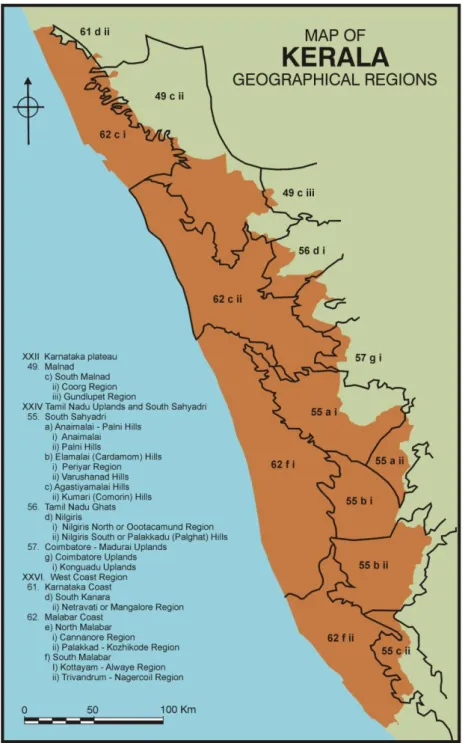
which three concern the state of Kerala and the adjacent parts of the neighbouring states - the Karnataka plateau, Tamilnadu uplands and South Sahyadri, and the West Coast region. These are further divided into 9 first order, 27 second order and 54 third order regions of which 15 fall partially or fully within the political boundaries of the state of Kerala (see Fig 1.3) (GURUKKAL and RAMESH 2007).
Fig 1.3: Showing the fifteen geographical regions entirely or partly located in Kerala (Illustration A. George, adapted from GURUKKAL and RAMESH (2007)
9
The state is bounded by the Arabian Sea in the West and the southern part of the Western Ghats mountain ranges in the east. Its northern and southern boundaries do not have a physiographic basis. The Western Ghats rise from a very low altitude of a few hundred meters up to over 2000m. It consists of a number of peaks which are above 2000m in height. The continuum of the ranges is broken by occasional mountain passes like Aruvamozhi and Chenkottai in the South and the Palakkad gap in the centre. Over a long period of time the Palakkad Gap has functioned as an important route of exchange that connected the Western and Eastern coasts of Peninsular India. Archaeological indications of strong exchange networks exist from the prehistoric times, and are marked by the spread of non-local items of trade and prestige goods like varieties of semi- precious beads and ceramic types.
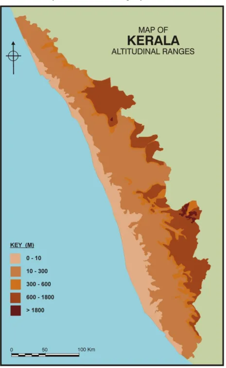
The state can be divided into five physiographic zones (SOMAN 2002) of which 4 are almost parallel and lying in a north- north west- south- south east orientation (See fig 1.4).These are:
The mountain peaks above 1800 m within the Western Ghats and constituting only about 0.64% of the total surface area of the state;
The highlands at an altitude of 600- 1800 m and occupying 20.35% of the land area
The midlands at the altitude of 300-600 meters occupying 8.44% of the area. This is constituted by the undulating Western fringes of the highland, the laterised rocky spurs projecting westwards, and parts of crustal breaks
The lowlands at 10-300 meters, which cover a maximum area of 54.17%. The lowlands are quite asymmetric with dissected peneplains, flood plains, valley fills, colluviums and sedimentary formations. They also comprise of undulating rolling hills and shallow valleys running along Central Kerala. Where the valleys are wide, the land is ideal for the intensive cultivation of paddy. The interfluvial areas and slopes hold different plantations. The village of Anakkara falls within this zone. Anakkara has a number of laterite
10
hillocks of the altitudinal range of 35 to 70 m. These are interspersed with low lying flatlands with paddy and coconut cultivation
The coastal plains and lagoons below 10 meters covering an area of 16.40% of the total. This zone is constituted by beach dunes.
The five zones are connected by an extensive drainage system.
Fig 1.4.Figure showing altitudinal ranges in Kerala (Illustration A. George, Adapted from SOMAN 2002)
11 Drainage: Channels of Communication
Water transport has been a major form of communication in the state from the pre historic times till date. The river channels offer the most convenient and cheap means for transportation and until recently, this has been the preferred medium for timber transportation. Timber depots were located along the banks of the rivers. Logan talks about floating down timber to the main stream of Kutiyadi via smaller streams. From “ ” (L 1887).
Our study area has yielded objects of non- local origin in association with a number of megalithic monuments. The exchange of these goods is channeled via routes operating through the waterbodies or along the banks of the major rivers. The late prehistoric- early historic port site of Pattanam is an interesting case in point. Pattanam is a hinterland port site, connected to the Arabian Sea and to the hinterland via the river Periyar. The site has yielded evidences of non- local produces and other items of trade that figured in Indo- Mediterranean exchange network arriving at the site via riverine transport. (CHERIAN, P.J. et.al. 2007). Researchers have indicated the tendency for megalithic sites to be concentrated along the alluvial tracts between branches of rivers and tributaries (ABRAHAM 2003)
Forty four rivers originate from the Western Ghats and cut across the state forming a network through tributaries and branches. These rivers are all perennial. Of these, forty one flow west-wards debauching into the Arabian Sea. The rivers are generally dendritic in nature. Most river courses are straight indicating structural control (SOMAN 2002). The kāyals or lagoons form a chain of water bodies running parallel or oblique to the coastline. This is a characteristic feature of the Kerala coast. It is a body of brackish, marine or hyper saline water, impounded by a sandy barrier and having an inlet connecting it with the open sea. Numerous perennial rivers discharge into the
Kāyals. The Kāyals of Kerala are mostly separated from the sea by elongated sandbars.
Perennial rivers debouch into the sea through these water bodies, compounding the system into lagoonal-estuarine, or partially mixed estuarine systems. (See Fig 1.5) Gurukkal and Varrier observe that the geo-physical peculiarities of the Kerala coast are conducive to water transport (GURUKKAL and VARRIER 1991). The kāyals and the channels connecting them form a water body traversing the length of the coastal regions
12
from Kozhikkode in the north to Kollam in the south. These water ways link the coast to the hinterland via the many rivers. The rivers, we have seen, are dendritic in nature spreading over the entire region. Thus the drainage system acts as channels of communication for the study area.
Fig 1.5: Drainage map of Kerala
13
The village of Anakkara lies 1.5 km south of one of the major west flowing rivers, the Bharatapuzha. Bharatapuzha is 209 km long. It originates in Anamala of the Western Ghats at an altitude of 1964 meters and flows into Kerala through parts of Coimbatore district in Tamil Nadu, flowing westwards through the districts of Palakkad, Malappuram and Thrissur before emptying into the Arabian Sea through the Ponnani estuary. Bharatapuzha is thus the major conduit linking Kerala with the regions east of the Palakkad Gap, as well as to the upland resource areas of the Western Ghats. The Coimbatore region has been a major industrial and trade centre for a very long time. Iron age sites like Kodumanal illustrate this fact (RAJAN 1994). The river has a number of tributaries and distributaries and acquires local names at different regions. It has basin area of 6186km2 (PRASANNAKUMAR 2007). At Anakkara area the river takes the name Ponnanipuzha, even though Ponnani town is about 14 kilometers east- south east of Anakkara.
North of Anakkara, Bharatapuzha meanders to form a loop towards the South. It has a width of over two kilometers and loops out south about two kilometers from the main course of the river. Meanders cause erosion on their outer sides and deposition on the inner side. They also broaden and move downstream. Hence we can assume that at the period of our interest, the course of Ponannipuzha was slightly off north from Anakkara than at present.
Climate
The state of Kerala falls within the ambit of tropical climate, and experiences the alternation of dry and wet climates. Certain areas in the Eastern region fall within the sub- tropical regime. Monsoons are a dominant feature of the region. Kerala experiences two monsoons, namely the south-west or Edavappathi (June to September) and the north-east or Thulavarsham (October to December). The seasonality of the monsoons had been used by the maritime traders to their advantage from the late centuries BCE. Occasional rainfall is also received between the two seasons. The average annual rainfall is about 300cms. March to May are the hottest months with temperatures reaching more than 320C, and the lowest temperatures are experienced during the months of December and January, as well as July, when the state receives
14
plenty of rainfall and the sky is cloudy. The average temperature for the state as a whole is 28.50C (SOMAN 2002).
The natural boundaries of the state contribute to its distinct physiographic and climatic characteristics. Kerala lies on the windward side of the Western Ghats. The Ghats break the South West monsoon winds causing heavy rainfall in the region east to it, while the neighouring parts of Tamil Nadu on the eastern side of the ranges fall within the rain-shadow region. Hence there is a stark contrast in the vegetation and climatic features between the two areas. The dense forest cover of the Western Ghats is also a contributing factor to precipitation. This acts as a substrate for the condensation of moist- rising orographic winds from the Arabian Sea, and release much of the moisture back into the air through transpiration, allowing it to condense and precipitate (SOMAN 2002)
Almost the entire state is covered by lush green vegetation over the major part of the year. The conditions are favourable for a distributed habitation pattern. Kathleen Morrison has pointed out, on the basis of Paleo environmental studies, that even from the forest tracts of the Western Ghats there are evidences of modest human induced vegetation changes from as early as the first century CE.( (MORRISON 2002) ). In the case of Anakkara we see that herbs and shrubs cover the entire hillock except for short spells. Even with the poor water retaining capacity of laterite soils, the undergrowth of shrubs and grass is thick and tall enough to block the monuments at the site from visibility.
The physiographic and climatic conditions of the state can be assumed to have a major role in the occupational patterns for the period under our concern. K.N. Ganesh observes how the undulating nature of landscape has influenced the patterns of production in Kerala (GANESH 2007). The nature of landscape limits the possibility of any production technique having a wide regional spread. This necessitates micro regional systems of production and accumulation processes that involve inter regional interactions. The riverine transport networks have a major role to play in this regard. However we do not have many studies that explore this aspect. Ganesh also notices how the place names in Kerala indicate its physiography (GANESH 2007). Suffixes and
15
prefixes of place names in Malayalam signify particularities of a landscape unit signifying how the landscape was organized into distinct categories of perception. Many of these place names have great antiquity. This can be ascertained by the presence of words that signify landscape features in the Tamil Sangam texts. Closer to the present, dense population distribution and the richness of vegetation in areas that have a relatively lesser density of population have hindered archaeological research in the state.
Geomorphological Evolution of Landscape3
Southern Peninsular India exposes lithological assemblages from Archaean to Holocene (GSI, 2010). Geologically, Kerala is occupied by pre-cambrian crystallines, acid to ultra- basic intrusive of Archaean to Proterozioc eras, Tertiary (Mio- Pliocene) sedimentary rocks and Quaternary sediments of fluvial and marine origin. (See fig 1.6) Both the crystalline and tertiary sediments are extensively laterised (GSI 2005). Almost all the rock formations of Kerala are aligned in the NW- SE direction. This is because the structural grain of the Southern Peninsula has a NNW- SSE trend and Kerala lies to the Western edge of this mega structure (GSI 2005)
16
Fig 1.6: Geological Map of Kerala
(Illustration A. George, Adapted from: SOMAN 2002)
The laterite outcrops and soils of the region are especially relevant to our study. Owing to the particular climatic conditions of the region, the geomorphic processes in Kerala are dominated by weathering and denudation. The climatic conditions affect weathering, soil formation, slope processes and river discharge and have significant control on the landform development of Kerala. (PRASSANAKUMAR 2007). The Archaean
17
crystalline rocks and the tertiary sedimentary rocks are extensively laterised. Laterites are seen up to an elevation of 2000 meters. However, the distribution has highest concentration within an altitude range of 50-150 meters above MSL and is mostly confined to an altitude of below 600 meters from MSL. This includes the lowlands and the midlands (SOMAN 2002).
The megalithic monuments built of laterite are unique to the Kerala region; of which most are made of laterite within the study area. They are conspicuous by their absence in the neighbouring state of Tamil Nadu where the presence of laterite is not extensive. Apart from the laterites, granites were also explored by the Iron Age communities of Kerala.
The landscape of Anakkara and the surrounding regions are characterized by laterite hillocks. Obviously, these were exploited for the construction of the monuments at Anakkara. The rocks are of a reddish colour as seen in figure 1.7. Generally, the laterite after the crystalline rocks is compact and the top crust is moderately indurated. The dark brown crust passes downward to pink and buff coloured soft laterite. Quartz vein joints and fractures can be traced from the top to the bottom of the laterite profile. Microliths in quartz were found during the excavations at Anakkara in the year 2008 (MGU 2008).
In tropical areas like Kerala weathering results in the formation of laterite with the removal of silica and fixation of certain oxides. The laterite formations of Kerala are Upper Tertiary. These are usually rich in oxides of iron or aluminum or both with or without quartz and clay (SOMAN 2002). The presence of Iron is indicated by the characteristic reddish colour. The interface of the coastal plains and lowlands abounds with laterite. The laterite zone is considered to be a good aquifer of ground water. During the excavations at Anakkara in 2009 it was brought to our notice that the construction workers working on an engineering college close to the site were using groundwater from a bore well dug nearby.
18
Fig1.7: Laterite formations at Anakkara exposed due to recent landscape alterations (Photo: Author 2010)
In central Kerala extensive blanket capping by laterite can be observed. Laterite formation results in the formation of a hard duricrust on a surface that is flat giving rise to formations called „ ‟ „ ‟ K H z „ ‟ (PRASANNAKUMAR 2007).Laterite is an important building material. In recent years this aspect has led to the bulldozing of a number of laterite hillocks. This is a direct result of the construction boom in the region prior to the economic depression. In Anakkara the process is still continuing (see Fig. 1.7). The hills on the vicinity of N have already been scrapped down to a large extent thus creating drastic alterations to the landscape. This has considerably affected the means of understanding the location significance of the sites in this study.
19 Quaternary Sediments and Soils
Recent to sub- recent sediments of coastal sand, sticky black clay with carbonized wood, silty alluvium and lagoonal deposits are observed mostly in the low lying areas from Kollam in the south, to Ponnani of Malappuram District in the centre, and between Kannur and Nileshwaram in the North. Alluvium is observed along the major river valleys.
Soil
Kerala has a thick soil cover over a large area with eroded pockets exposing hard laterite capping or crystalline rocks. The soils can be excessively drained to moderately well drained, with sandy to clayey texture, a major part being loamy. The soils of Kerala can be classified into eleven broad groups based on the morphological features and physico-chemical properties. These are Red loam, Laterite, Coastal alluvium; Riverine alluvium, Grayish Onattukara, Hydromorphic, Hydromorphic saline, Black soil, Kuttanad alluvium, Black Cotton soil and forest loam (PRASANNAKUMAR 2007). Laterite soil occupies about 60% of the total area of Kerala and a major part of the study area. It is mainly confined to 20 meters to 100 meters above MSL. On the hillocks of Anakkara, the laterite soils are shallow (with less than 50 cm depth) and are indurated with laterite outcrops. Laterite soils are poor in nitrogen, phosphorous and potassium and are acidic. The organic matter content is less than 1%. These have a low water holding capacity, and are prone to erosion. Soil of this kind is suitable for dry land crops. Local inhabitants at Anakkara recounted that less than fifty years ago, the major vegetation of the region consisted of cashew trees, Njaval trees and mango trees. These, more often, were in the form of untended vegetation. As the soils are poor in terms of their fertile qualities, one can assume that the monuments within the study area are constructed on marginal lands (marginal to agricultural production), similar to many other areas that has megalithic monuments around the world (JOUSSAUME 1985)
The Temporal Span
There is a dearth of absolute dating for Kerala megalithism. The chronological span of its spread, is a conjunct arrived in academic discourse based on the archaeological data from other parts of South India- both absolute dates and comparisons drawn on the basis
20
of associated artefacts- and on the non- archaeological sources with or without direct references to the phenomenon. Scholars differ in their opinion on the period of spread of megalithism, with dates as early as the first millennium BCE being suggested for its beginnings (PETER 2002; SATYAMURTHY 1992). The practices are seen to have continued up to mid first millennium CE (GURUKKAL and VARRIER 1999, PETER 2002, ABRAHAM 2002). This is a broad chronological span, which particularly in the absence of site specific dates, limit the general academic discourse on megalithism to a great extent.
The multiple source categories that are employed in this study are selected because their referents fall within this broad time span. In South Indian historiography this time span has been relegated to the late- prehistoric – early historic continuum. The division of history into successive, universally recognised periods is conventional in history writing. In the case of South India the above divisions are largely accepted by the archaeologists. The division between the two phases is not a clear cut one. However the assumption is of an Iron Age characterized by Iron smelting people which includes the early phases of megalithism followed by the proto/ early historic. The assignment of the second phase is based on the availability of textual (non- archaeological) sources that refer to it. Such divisions based on universal categories of periodization tend to be mechanical sometimes and this study expects to address this question in the course of the discussion.
The Sources
Archaeological
There are a number research projects that have embraced a megalithic culture as a world tradition. This implies that megalithic building their use and their demise seemingly follows a recognised pattern of events that is witnessed throughout the megalithic world (JOUSSAUME 1985). The megalithic monuments within my study area are no exception to this. Specific reports and mentions of the megalithic sites of Kerala region figure in the early colonial writings, Annual Reports and other publications of the Archaeological Survey India (ASI), the publications of the state departments of archaeology of the Travancore and Cochin states and a few independent studies
21
conducted by different university departments of archaeology in India. These works will be discussed in detail in the following chapter with a focus on the broad theoretical trends as well as their scope as source categories. The present study also takes into account some sites from the rest of Peninsular India, as megalithism of the sub-region is culturally and chronologically a part of South Indian megalithism as a whole.
Anakkara, our region of closer focus was excavated during two seasons in the years 2008 and 2009. These excavations were conducted by the Mahatma Gandhi University (MGU) of Kerala and directed by Rajan Gurukkal. The reports of these excavations are not yet published. As the excavations were constrained for time due to climatic and economic reasons, the analysis of the excavated material was not completed on site and is in progress. The information used in this study is based on the unpublished daily reports of the excavations (MGU 2008, 2009) and the input from the participants. Five trenches were laid out in the 2008 season. In 2009, excavations were conducted at N , of Anakkara, which is the subject of the fieldwork conducted in this order as part of the present study. The author was part of the 2009 excavations and explorations. The detailed discussion of the excavations is included in Chapter 4.
During the months of October and November 2010, the author along with Sreelatha Damodaran, research scholar, Department of History, Calicut University conducted fieldwork at Nasranikunn, Anakkara. The methodology followed, and the information thus collected will be presented later in the course of the discussion. This fieldwork period was followed by one week of work as part of the musealisation project of the MGU in Kottayam, Kerala. A part of the project was associated with the excavated material from Anakkara and certain additional observations were made during the period.
While the focus of our discussion is the archaeological data from the region itself, there are other source categories that pertain to the period that are employed here in a limited way.
22 Numismatic
Finds of punch marked coins 4as well as Roman coins from the late centuries BCE to the early centuries CE have been reported from many parts of Kerala, like elsewhere in peninsular India. Two catalogues of coins published by the Department of Archaeology, Government of Kerala in 1965 and 1992 give the major portion of information in this regard (GUPTA 1965, SATHYAMURTHY 1992b). Roman coin hoards were recovered from a number of sites like Kottayam (Kannur District), Iyyal, Kumbalam and Vallluvalli. Associated with the Roman aurei and denari, silver punch mark coins were also found. There are also stray finds of coins. The coin finds are often associated with prehistoric contexts. However a problematic tendency till now has been to study them independently. Hence the possibility to incorporate them in the present study is highly limited.
Textual
The textual sources pertaining to the period falls primarily under two categories. The first are the Greco Roman classical accounts including the the Periplus Maris Erythrae [PME] or The Periplus of the Erythræan Sea by an unknown author, the Natural History by Pliny and the Christian Topography by Cosmas Indicopleustes belonging to the first centuries CE. Their relevance to the present study is minimal.
The second group are early Tamil texts of poetics known as the Sangam anthologies. It consists of Ettutokai (the eight anthologies), Pattupattu (the ten idylls) and
Patinenkcilkanakku (the eighteen didactical texts). The ancient Tamil anthologies and
poetics were compiled during the early centuries of the Christian era. The oldest among these could refer to an earlier period. Apart from direct references to the burial practices and the associated environmental motifs, the texts can be used to situate the life and culture of the period. The anthology that will be employed here mainly is the
Puṟanāṉūṟu (in translation).5
The Puṟanāṉūṟu is an anthology of four hundred poems belonging to Ettutokai (the eight anthologies). These poems are among the earliest included in the early Tamil corpus of anthologies. While a detailed independent study of
4 'Punch Marked' coins were issued between the 7th-6th century BC and 1st century AD in several parts of the sub continent. These
coins are called 'punch-marked' coins because of their manufacturing technique. Mostly made of silver, these bear symbols, each of which was punched on the coin with a separate punch RBI Monetary Museum)
5 The translations of Puṟanāṉūṟu used here are HART, George, and HANK, Heifetz (ed. and trans.) (1999) The Puṟanāṉūṟu .The
23
the texts is not within the scope of the present work, the effort would be to form an understanding regarding the integrated employment of multiple source categories which refer to the same spatio- temporal context.
The idea of Tamilakam and the Tinai – based Social Formation Paradigm
As will be discussed in detail in the following chapter the historiography of early south India relies heavily on the Tamil Sangam texts often at the expense of other source categories. The text based models of periodisation are co- opted into archaeological research as well (RAJAN 1994).
A dominant view in South Indian historiography is a characterization of social formation that can be called the tinai -based paradigm applied across an assumed geographical span, Tamilakam. Like current political boundaries, the assumed geographical spaces serve to frame the historical writings especially in defining the limits of their spatial span. Most of the writings on early South India assume that
Tamilakam exhibits more or less uniform features that separate it from the rest of
peninsular India. The idea of Tamilakam comes from the Sangam texts and is usually ‟ 6
The tinai concept of social formation (see fig 1.8) regards the Tamil anthologies as central to the characterisation of social formation for the region (GURUKKAL 1989, VARRIER 1990). According to this view, the whole of Tamilakam that includes the present day states of Tamil Nadu and Kerala, exhibits more or less uniform features. It is held that
Tamilakam consists of five types of landscape ecosystems or the tinais, viz, kurinchi
(the hilly backwoods), mullai (the pastoral tract), marudam (the wet land), neidal (the littoral) and palai (the parched zone). Each tinai has produces, environmental correlates, behavioural patterns, deities and modes of occupation specific to it. This compartmentalization necessitates inter-tinai exchanges.
6 In this world massed together of earth that the wind/ cannot penetrate, dressed in sky and surrounded/ by the broad vast sea, of the
24
Fig 1.8: Diagrammatic representation of the tinai- based model of social formation
Vis- a- vis archaeological data, like the categorization of periodization, the tinai based
model is also often un problematically applied. The inherent problem in these assumptions is „Sangam’ corpus of literature was collected much later than the period it refers to. The compilation itself is an act which involves mechanisms of filtering, mediation and selection that happened over a period of centuries and deeply ingrained within the temporal and ideological context in which it occurs. Hence, what is selected in the corpus of literature available to us is but part of a larger and possibly varied oral tradition. And the available texts themselves, rather than being efforts to characterize social formation are poetic expressions on themes like war and love replete with metaphors and motives. Hence their employment as a source category must be done with due caution and it is highly problematic to accept the geographical categories as given in the analysis of archaeological sources. As S , “I -based „„ ,‟‟ , -based distinctions as the more appropriate scale of analysis when examining the K N ” ( H M 2003) 7
The spatio temporal context has not been invoked here as a static backdrop. The present political boundaries have, no doubt, influenced the choice of the study area. Obviously,
25
such divisions had nothing to do with the imagination of space in an earlier period. The geological and physiographic features observed above are not conceived as categories or templates on which the life world of a community can be superimposed. Landscapes are constituted experientially, and in relation to humanly created locales that, in turn, may derive their meaning from the qualities and configuration of the landscape (TILLEY 1994). Thus there is no singularly defined landscape. Space, to follow Harvey, is dynamic and rather than being a passive frame, is an active moment in the construction of politico-economical, physical, ecological and social life (HARVEY 2001). Hence, the effort is to see how, given the limited nature of the sources at our disposal, the dynamics of a lived space can be conceived.
The next chapter attempts a review of the existing discourse on the megalithic tradition of Kerala and the way it has been employed in the historiography of the region. This should place the present study in a better focus by mapping the general trends and identifying the gaps in the available knowledge base.
26 CHAPTER 2: REVIEW
This chapter explores the nature and scope of the existing works on the megaliths of peninsular India, especially Kerala region and provides a comprehensive literary review. It looks at examines the way the monuments form part of the public perception of the region and how the local populace deal with their presence. The chapter also explores the major trends in the historiography of early historic Kerala focusing on the way in which history writing has dealt with the existence of multiple source categories corresponding to the same spatio- temporal span and the broader theoretical approaches that these works have taken. The effort is to bring together the multiple perspectives that have gone into our existing knowledge of Kerala megaliths and to identify the gaps therein.
Archaeological Studies on Kerala Megaliths: Nature and Scope
The colonial writings on the megaliths of South India date back to the early 19th century. They form the first corpus of published literature on the pre historic remains from South India. Prior to that and as can be delineated from these writings themselves, the burials were a part of the life-world of the local populace, who dealt with them in varying manners.
The first published report of the excavation of a megalithic burial in India was that of J Babington (BABINGTON 1823). It related to his excavations at Chataparamba of Kozhikode district of Kerala. This earliest description of the excavation of a
‘kodey-kal’8
, is also noteworthy due to a number of reasons. Babington gives the locational
peculiarities of the site, describes the surrounding sites, and explains the methodology of excavation followed as well as supplemented the description with sketches. He also attempted to connect the site to the other sites that he had already encountered. The methodological rigor that is present in this first report however tend to be missing in the studies that followed. It should also be noted that Babington does not refer to the monuments as megaliths or draw short circuited comparisons with the European megaliths as many later studies tend to do.
27
In 1882, Robert Sewell compiled a list of known inscriptions and antiquities from the Madras presidency. He was appointed on special duty with the Southern Zone of Archaeological Survey of India (ASI)9 by the Government of Madras. In three separate sections for Malabar, Cochin and Travancore10 regions Sewell notes 300 sites among (D S N 2006) S ‟ not aim to provide more information than the place names where the sites are located (SEWELL 1882). However it remains significant as the first documentation of this kind from the region.
The Anuual Reports of the Archaeological Department, Southern Circle of the early decades of 20th century, contain a number of descriptive accounts of monuments. In the report for the year 1910-1911, rock cut caves of Perungulam in Thalassery are described in details along with dimensions of the burial goods (REA 1911).
The narrative accounts of the colonial administrators of the prehistory of the region were primarily published as manuals and Gazetteers. These accounts tend to be descriptive, thus underlining the colonial order. In 1887, Wlliam Logan, an officer of the Madras Civil Service under the British Government, published Malabar (LOGAN 1887). As a colonial administrator, the understanding of Logan of the governed, and j “ L ” K V , “ j z ” (VELUTHAT 2000). Logan assumed for the people a civil constitution that remained unchanged over “ M 11
race has produced no historians ” (LOGAN 1887). His inability to effectively employ the above mentioned source categories and his exaggeration of the lack of indigenous sources have to be understood in this context.
Logan wrote Malabar when studies on the megaliths of Kerala had already been under way for a few decades and he recognised that this archaeological material is of „ ‟ L sources he mentions
9 The Archaeological Survey of India was found in 1861 by the colonial administration. Post-Independence, the ASI is a department
of the Government of India under the ministry of Culture.
10 The princely states of Cochin and Travancore and the Malabar district together formed the state of Kerala in 1956. 11 Refers to the people who speak the language Malayalam, the official language of the present state of Kerala
28
in the section „E H O S ‟ utility as limited to the study of religion. He regarded them as expressions of the earliest form of Hinduism, which was eventually replaced by a superior Brahmanism, in a process conceived as a unilinear transition even as some of its aspects survived.
Towards the end of the 19th century, a number of studies surfaced as short length articles in the different journals published by the Royal Anthropological Institute of
Great Britain and Ireland. Some of them are primarily descriptive in nature and focus
on drawing comparisons between sites and artefacts. (CAMMIADE 1930; FAWCETT 1896a; FAWCETT1896b). Plenderleith, in 1896, published a short note on the chemical composition of the glaze on black polished pottery from urn burials in Wynad (PLENDERLEITH 1896). This is however the only study of the kind from the period. Codrington, in 1930, identifies the culture as part of one that spreads across South India and the Deccan based on his survey of the pottery from the urn and cairn burials (CODRINGTON 1930). Unlike the studies mentioned above Codrington examines at some length the ancient corpus of Tamil poetry called the Sangam literature as well as the burial practices of the time in India to reach his assumptions about the nature of the burials. He considers them to be of two types- primary and secondary. Also by this time there is the assumption, reached through the comparison of burial goods that the different burial types refer to the same cultural complex (FAWCETT 1896 a; CODRINGTON 1930).
The Archaeological Survey of India (ASI) as well as the State Departments of Archaeology of Travancore and the Cochin State conducted a few studies after the 1940s. The efforts of V.D. Krishanswami, Anujan Achen and others made these studies „ ‟ a wide range of burial practices from South India. Hence, comparisons with practices across the globe that come under the term begin appearing in the studies. Many of these early writings on the megaliths of Kerala focused on the description of the monuments. Problems of nomenclature, chronology and origin were also taken up at different times.
In 1947, an article by Gordon Childe (CHILDE 1947) was published in the journal
29
together a vast amount of evidence from around the globe including that on the megaliths of South India. He found that complexes of traits, like collective burials and port holes, are regularly associated with the monuments. These differences and similarities form the basis of inclusion or exclusion of a category of monuments within the classification. The system of classification based on a complex of associated traits, thus cannot accommodate a wide range of monuments, including many of the subterranean rock cut caves of India. Gordon Childe proposes the likely origin of the megaliths to be around the Eastern Mediterranean and suggests a diffusion that was effected either by land or by sea by multiple possibilities of human agents (CHILDE 1947). Krishnaswamy observed that the megalithic monuments of South India belonged to an altogether different cluster. He attributed their difference to the different „ ‟ I „ ‟ o the mixture of influences and rituals in these cultural regions (KRISHNASWAMY 1949). Changes are perceived not as products of processes operating from within but as imposed through outside influences either by actual contact or through a diffusion of ideas. Varying theories of diffusion have been proposed hence. Allchin and Allchin argued for maritime influence from the Middle East and B.B.Lal suggested Heliolithic diffusion. Haimendorf argued that that the builders of megaliths came from the near East (PARAPOLA 1973). Apart from pondering into the direction and channels of this possible diffusion, the studies based on the diffusionist approach have the limited scope of simple descriptive accounts. Explanations are not offered for the observed cultural similarities and differences.
K „ z ‟ „ ‟ (K ISHN SW MY 1949) H focused on the three regions that had been subjected to detailed ground survey since 1944 -- Chingleput, Pudukkottai and Cochin. He sought to describe the monuments from these regions in detail owing to the variations they exhibited while belonging to the same megalithic complex. While describing the physical attributes of the monuments of the Cochin region, he observed that the region as well as the whole of Kerala included three parallel physiographic strips that have yielded distinctive monuments. The architectural features of these monuments were thus determined largely by the material available.
30
Krishnaswamy also looked at the living megalithic cultures of the aboriginal tribes of Assam, Chota Nagpur and Bastar. He observed the structural features and functional utility of these monuments as well as the ethnological affiliations of the builders. However his major concern was the classification of monuments and hence he did not seek to elaborate upon these arguments.
The excavation of the urn burial site of Porkalam was undertaken by B.K. Thapar in 1948 (THAPAR 1952). Porkalam is a multiple monument site located in Talapilly taluk of Trissur district. In 1956, Y.D. Sharma undertook a detailed study of the rock-cut caves of Cochin (SHARMA 1956). His concern was that despite the significant q “ comprehensive study of them, geographically, architecturally or culturally has yet been ” (SH M 1956) H ocused primarily on describing the general physical features and aspects of construction of these monuments. Sharma also took up the question of origin of the rock cut caves, that is, whether they could be assigned to the category of megaliths or not. He built up his argument through systematic comparisons of this monument type and associated burial goods with the other megalithic types from the region. The problem of chronology was also briefly taken up with specific reference to the caves. Rather than going deeply into the problem he accepted a general chronology for the megaliths from the earlier studies on South Indian megaliths to which the rock cut caves were also assigned.
During this period the local scholars on South Indian prehistory and history also are E K I ‟ K N “I ”, I , sift from the scrap heap of information about the prehistoric antiquities of Kerala and arrange them in their proper perspective with the aid of ethnology on the basis of E ” (IYE , 1948) H P Neolithic that was a period of innovations including megalithic tradition and South India acted as the emanating centre of Neolithic culture to other parts of India (IYER 1948). This is contrary to the evidence already available that that in South India megalithic tradition was a phenomenon primarily associated, not with Neolithic
31
implements, but with Iron using communities. Iyer, directly adopting the European models of the Neolithic, overlooks this.
Iyer also uses ethnographic information extensively. He is able to view the people of Kerala as a whole in a socio-historic perspective and the megalith builders are considered as the earliest settlers of the region. The thrust of the work is on describing the megalithic remains of the region with reference to the surviving ethnic groups and their landscape. The function of prehistoric archaeology, for Iyer, was to deal with “ q ” “ q ‟ ” (I 1948) mption was that the megalith builders who were the early settlers of the region were suppressed by the waves of immigrants and invaders who are represented in the historical sources. Hence his attempts were limited to tracing the tribal ancestry of the megalith builders through funerary practices surviving among certain modern tribes of India.
Elamkulam Kunjan Pillai was one of the first to realise the significance of megalithic ” (G NESH 1999) P ‟ y titled
‘Kurangukalude Pattada’ from Annathe Keralam (PILLAI 1959) focused on the
P ‟ history of Kerala to be published in Malayalam. I E ‟ knowledge of megaliths was based on his direct participation in excavations and ‟ orientation is reflected not only in his approach to the texts but also to the archaeological sources. The nomenclature assigned to the megaliths in the texts and in local parlance formed one of his major concerns. It is through a discussion of these that he reaches his assumptions regarding the ethnicity of the megalith builders.
The ASI has reported a number of megalithic sites from Kerala in the post- independence period. These reports came up in the annual reviews of ASI titled Indian
Archaeology: A review. Here the volumes from the 1950s to 2000 are examined. The
majority of the reports mention only the location of the site and type of monument. Some of them go on to describe the morphology of the monument. Among these sites
32
some are accidental finds encountered during land mining or construction activities. Some others have been found during explorations conducted by the department. In some cases these are supplemented with photographs. ASI has conducted a handful of excavations. There are no detailed systematic reports available for these excavations, except in the case of Cheramangad where the report is richer in detail in comparison to the others.12
Among the few megalithic monuments from Kerala that have undergone systematic excavations are Machad and Pazhayannur of the Talapilly taluk of Thrissur district. The excavations of Machad and Pazhayannur were undertaken by K.M. George and Mehta ‟ (GEO GE, 1975)and the report was published by the Department of Archeology, M.S.University, Baroda as a short monograph (GEORGE & MEHTA 1974). G ‟ sis (GEORGE 1975) had a two-fold aim- two develop a systematic study of the material culture of Kerala and to try to understand the history of the region. This was deemed necessary in the absence of systematic explorations and excavations from the region (GEORGE 1975). George identified in the course of his research forty one new Megalithic sites. He gives short physical descriptions of the sites and goes no further. Three megalithic monuments were excavated, two in Machad and one in Nadappakund of Pazhayanur district. George examines the different diffusion theories on the origin of Kerala megaliths but refrains G ‟ the available information on the megaliths of Kerala. He is hence able to make suggestions on the nature of distribution of different monument types. George argues that the monuments directly reflect social ranking as can be deduced from the amount of labour that went into the construction of each.
From the early 1970s a number of monographs began to appear on the megaliths of South India. These works, based on already published information, seek to arrive at broad theorisations. The studies more often have broad regional scope including the entire peninsular India (PARPOLA, 1973; RAMANNA, 1983) or deal with a specific sub region within peninsular India (RAO, 1988) Theories of diffusion are still a
33
dominant theme in these studies. In 1983, H.S. Ramanna produced a monograph that discusses the structural peculiarities of the megaliths of South India and South East Asia. In addition to morphology Ramanna also seeks to draw similarities between the two regions in terms of burial goods. On the basis of comparisons, he arrives at the “ evidence to argue in favour of diffusion cultural contacts between the iron using megalithic builders of South India and various part of South East Asia extending to Philippines and Formosa13” ( M NN , 1983) origin of South Indian megalithic tradition as we see above is a major concern. Parpola , „ ‟ (P POL , 1973) P “ ” (PARPOLA, 1973). He assumes that the existing Neolithic populations adopted useful q , “ ” P argues for an Aryan invasion by land bringing in new elements into the megalithic culture.
K P ‟ Deccan Megaliths (RAO, 1988) focused on the region represented by the modern states of Andhra Pradesh and Maharashtra. There are about 40 excavated sites apart from nearly 300 explored sites in the area covered. Of these, 271 are listed and the discussion is based mainly on the forty excavated sites. The study, the author claims, involved extensive explorations and field work. One of the major assumptions of
Deccan Megaliths is that Megalithic practices were introduced from other regions as a
result of migration. He shares Gordon Childe‟ M centre of origin for the megalithic culture in general. For the introduction in the Indian subcontinent, he suggests that there could have been more than one source and route. The diffusionist bend brings questions of ethnicity, migration and contact to the centre of works. Following this, inter-regional similarities and differences of monuments form a major tool of analysis in addressing problems other than the above as well.
H ‟ it raises questions other than those on I “ to appreciate the
way of life of the megalithians ( )”, (RAO, 1988). The forty sites under
study are divided by him into four zones. The basis of this division is not clear. But Rao