Environmental &
Engineering Geoscience
THE JOINT PUBLICATION OF THE
ASSOCIATION OF ENVIRONMENTAL AND ENGINEERING GEOLOGISTS AND THE GEOLOGICAL SOCIETY OF AMERICA
SERVING PROFESSIONALS IN
Dynamics of Coastal Systems Using GIS Analysis and
Geomaterials Evaluation for Groins
ANA C. PIRES
GeoBioTec Centre (3G—Georesources, Geotechnics and Geomaterials Research Group), University of Aveiro, 3810-193 Aveiro, Portugal; and the Laboratory of Cartography and Applied Geology (LABCARGA), Department of Geotechnical Engineering, Institute of Engineering (ISEP), Polytechnic of Porto, Rua do Dr.
Anto´nio Bernardino de Almeida, 431, 4200-072 Porto, Portugal
ALBERTO GOMES
Department of Geography (Laboratory of Physical Geography), Faculty of Arts, University of Porto, CEGOT Research Centre, Via Panoraˆmica,
s/n 4150-564 Porto, Portugal
HELDER I. CHAMINE´
GeoBioTec Centre (3G—Georesources, Geotechnics and Geomaterials Research Group), University of Aveiro, 3810-193 Aveiro, Portugal; and the Laboratory of Cartography and Applied Geology (LABCARGA), Department of Geotechnical Engineering, Institute of Engineering (ISEP), Polytechnic of Porto, Rua do Dr.
Anto´nio Bernardino de Almeida, 431, 4200-072 Porto, Portugal
Key Terms: Coastal Dynamics, Hydraulic Structures, Geomaterials, Coastal Geoengineering, GIS
ABSTRACT
Shoreline change in the Espinho area (northwest Portugal) is a chronic problem. The present study takes advantage of geographical information system (GIS) tools to contribute to the knowledge of the geologic and geomorphological dynamics of the Espinho shoreline. A GIS-based monitoring project was compiled, which gathers information on all coastal works located along the Espinho shoreline, focusing especially on construction, monitoring, and repair aspects. Shoreline change was analyzed using the ArcGIS extension ‘‘Digital Shoreline Analysis Sys-tem’’ (DSAS) to understand this important aspect of coastal management. This work also emphasizes the importance of geotechnical assessment of coastal protection structures in diagnosing their degree of damage and/or deterioration so that one can plan more efficient maintenance works. Our results indicate a general trend of erosion to the south and accretion to the north of the Espinho coastal area. Geoengineering characterization of the Paramos groin defines three main zones for the armor block materials (i.e., Zones I, II/III, and IV), which show, respectively, very low, medium to high, and low deterioration levels.
INTRODUCTION
new, more ‘‘environmentally oriented’’ ethos of coastal management is emerging, one that is based on more holistic, transdisciplinary, and integrative principles and that aims at sustainable management of coastal resources. This new philosophy depends, however, on a thorough understanding of the entities and relationships at work in the coastal system, which in turn demands a solid base of data and information to be harnessed in support of decision making. Thus, for these and many other reasons, coastal scientists, engineers, and administrators are increasingly looking for new developments in information technology, tools, and methodologies that might assist them in their work (Carter, 1988; McCleese, 2000).
One crucial part of any successful coastal mainte-nance program is its monitoring (McCleese, 2000). The complexity and scope of a monitoring effort can vary widely, from simple periodic on-site visual inspections at the low end of the scale to elaborate and expensive long-term measurement programs at the other ex-treme. The most important aspect of any monitoring and inspection program is the careful determination of the purpose of this issue. Without a clear definition of the monitoring goals, resources and instruments will not be used in the most beneficial manner, and it is likely that the information gathered will be insufficient to accurately evaluate the project and to recommend appropriate maintenance programs.
One of the most important aspects of coastal management and planning programs that requires further investigation is shoreline dynamics. This term includes not only the progression and erosion of coastlines, but also protection against erosion. The latter is a complex problem, for which different methods and coastal structures may be used to protect the shoreline, according to the specific framework. Groins are among the most common structures built for erosion control. These are transverse coastal structures, the function of which is to intersect the waves to minimize their erosive power; they are also designed to regulate littoral sediment transport in order to stabilize the beach (Gomes, 1977; USACE, 2002). Normally groins are built in groups designated as groin fields. These coastal defense works may be integrated with longitudinal constructions, and in some cases they may be artificially nourished (LCPC, 1989; CIRIA/ CUR, 1991; USACE, 1995; and CIRIA et al., 2007). As a result of their characteristics, these structures are designed under the assumption that maintenance and repair work will be needed during the life of the structure (USACE, 1990; Silva, 1996; and Santos et al., 2003). Geographical information systems (GIS) provide ideal platforms for acquiring coastal infor-mation and for analysis of this data with an eye
toward monitoring coastal zone progression and defense. GIS are highly suitable for analyzing geologic and geomorphological data, revealing trends and interrelationships that would be more difficult to discover in tabular format. Moreover, GIS allow policy makers to easily visualize problems in relation to coastal erosion and the condition of existing protection structures for effective resource utilization. In Portugal, the coastal zone of Espinho is situated on the western Atlantic shoreline of the Iberian Peninsula. In this area, the erosion phenomena are usually intense and have been well known since the 19th century. To protect this part of the Portuguese shoreline several structures have been constructed— the majority during the past. In Portugal, several public institutions share the responsibility for coastal zone management, which sometimes gives rise to overlapping or ineffective actions (MAOTDR, 2008). Nevertheless, the prime legal authority can be identified as being the Ministry for Towns, Territorial Planning and Environment, especially through the Portuguese Water Institute (INAG) and the Institute for Nature Conservation and Biodiversity (ICNB). In fact, INAG and ICNB together have jurisdiction over all of the Portuguese coastal zones, except for the areas under harbor jurisdiction.
The main goal of this work was the application of GIS tools and concepts to the study of the Espinho coastal zone. This involved the creation of a GIS-based monitoring program to gather information on all coastal works located along the Espinho shoreline, focusing especially on construction, monitoring, and repairing aspects. A long-term estimation of the erosion and accretion rates in several different locations was then performed using GIS extension tools. This analysis allowed us to make predictions on future displacements of the Espinho shoreline. Finally, a geotechnical mapping evaluation of the rock blocks used in groins from the Espinho shoreline was carried out, based on lithology, weathering grade, and stiffness of the rock materials.
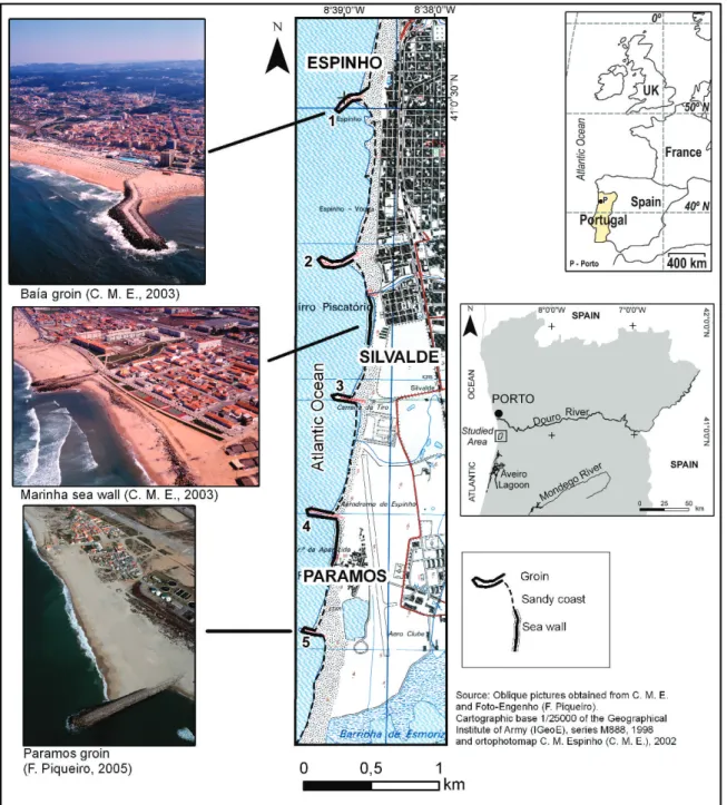
STUDY AREA
Coastal erosion in Espinho has been popular news, recorded since 1869 (Lima, 1979, 1982), as evidenced by several historical documents (Figure 2). Indeed, the first reported erosion dates back to 1860 (Ortiga˜o, 1876), and old maps show that the urban area of Espinho was much larger, extending further seaward to positions that have since been lost to the sea (Bandeira de Melo, 1870, 1900, in Lopes [1995]). The continuous retreat and advance of the Espinho shoreline several meters landward and seaward led to the construction of the first defenses, in 1909, but by 1911, these had been naturally destroyed. Since
then several protection structures have successively been put in place to protect the city (Perdiga˜o, 1931; Mota Oliveira and Martins, 1991; Mota Oliveira et al., 2000; and Trigo Teixeira, 2003). Figure 2 illustrates not only the occurrence of some disastrous episodes of sea invasions in the Espinho region but also some evidence of the construction of protection works. This historical compilation of events demon-strates the importance of coastal research in the area. Presently, two large groins, one in the north and another in the south, and two seawalls comprise the main structures protecting the seafront of Espinho,
and the situation is considered to be stable. The main erosion problems persisting in the downdrift area are due to lack of sediment transport. The most vulnerable area in terms of erosion is the urban seafront of Paramos (Veloso Gomes et al., 2003), located in between Espinho and Esmoriz. The main problems identified in this narrow strip are due mostly to sandy coastal areas that have no natural rock protection, where continuous erosion results in destruction of almost all sand dunes (Dias et al., 2000). Table 1 summarizes the main characteristics of the groins from the Espinho region and the designations used for each coastal structure (see Figure 1), along with the types of different ap-proaches studied.
Geological and Geomorphological Overview
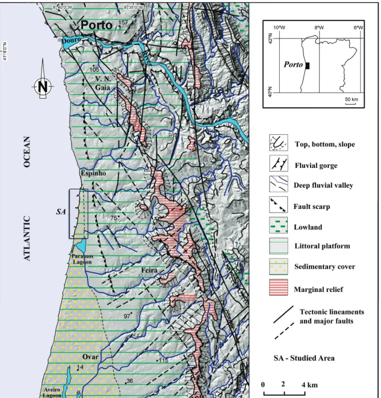
The regional geology of the Espinho area is related to two different Iberian geotectonic domains: meta-sedimentary and crystalline bedrock, belonging to the Ossa-Morena Zone (Chamine´, 2000; Chamine´ et al., 2003), and the northern part of the Lusitanian sedimentary cover, a tectonic basin developed like an aulacogen during Meso-Cenozoic times (Arau´jo et al., 2003; Gomes et al., 2006, 2007; and Gomes, 2008). The shaping of coastal landforms has been influenced by a range of morphogenic factors. While some coastlines have changed little over the past 6,000 years, most have advanced or retreated, and some have shown alternations of advance and retreat (Bird,
1997). The Portuguese coast between the city of Espinho and Mondego cape is undergoing morpho-logical changes (Dias et al., 2000). One of the most common characteristics of this littoral stretch is the so-called littoral platform (Arau´jo, 2002), encompass-ing different altitudes and bordered from the inland by a contrasting straight relief (Figure 3). The littoral platform ranges from 75 m in elevation (on the north, close to Ave River) to 130 m in elevation (at the south) and drops down toward the sea like a staircase (Brum Ferreira, 1983). This platform is bounded to the east by a step relief (i.e., the marginal relief) (Arau´jo, 1991) and is a regional fault scarp related to the Porto-Coimbra-Tomar shear zone (Chamine´, 2000; Gomes, 2008). This planation surface is generally covered with several outcrops of Plio-Pleistocene deposits (Teixeira et al., 1962). This platform has been considered a stable staircase of old marine deposits, indicative of the eustatic fluctuations. However, recent studies bring new insight that many of these deposits have a continental origin (Granja et al., 1999; Arau´jo, 2002).
MATERIALS AND METHODS
Three different cartographic sources were used for the study of the Espinho coastal zone: (i) the Pre-project Planning for the execution of the coastal protection structures in Espinho region presented by SOMAGUE (1980); (ii) the Espinho City Council cartographic base of 1993 (scale 1/5,000); and (iii) the 2002 ortophotomap of Espinho City Council. Two other additional sources of information were used to elaborate the GIS-based monitoring project: (a) the monitoring data available at SNIRLit—National Information System of Littoral Resources (SNIRLit, 2002)—and (b) the basic information on coastal works from the Espinho region previously compiled by Pires (2005, 2007) and Pires et al. (2006, 2007). The
latest records on the Espinho coastal zone available in SNIRLitdate back to 2002. The information on the coastal works includes data related to the design features of the structures (e.g., location, cost, length) as well as their actual condition, eventual pathologies, and needed repairs. These information sources were georeferenced, and all the data were rectified before vectorization using more than 20 control points. The vectorization was used to represent beach areas, protection structures, and bathymetric information (0.0 and+5.0 m.s.l., mean sea level).
The study of the variation of the Espinho shoreline focused on the analysis of the coastal dynamics and the spatiotemporal changes of coastal morphology for the period between 1993 and 2002 and took advantage of the Digital Shoreline Analysis System (DSAS) exten-sion. DSAS is the most user-friendly and powerful tool currently available for measuring the shoreline dis-placement. It was originally developed by Thieler and Danforth (1994) using loosely coupled programming techniques. The current versions use the ArcView Avenue Macro language, which converted the tool into an extension of ArcView 3.3. Within an ArcView environment, DSAS can benefit from other GIS capabilities of ArcView, such as importing of shape-files, coverages, and grids, as well as editing and changing projections. The latest version of DSAS can be downloaded freely from the U.S. Geological Survey web page (Thieler et al., 2005). DSAS is an extension that enhances the normal functionality of ESRI ArcGIS software and enables users to calculate shoreline rate-of-change statistics from a time series of multiple shoreline positions. The extension was designed to aid in historic shoreline change analysis (Bailey and Gatrell, 1995). DSAS is also useful for data sets that use polylines as a representation of a feature’s position at a specific point in time, such as the forward limit of a glacier; river channel boundaries, and land use and land cover maps. DSAS works by generating
Table 1. Summary of the main characteristics of groins in the Espinho region (compiled data from SOMAGUE [1980] and Veloso Gomes et al. [2002]).
Protection Structure Designation
(present study) ID*
Type of Coastal
Structures Location Construction Date Length (m) Groins Geotechnical Evaluation Evaluation (SNIRLit, 2002)
DSAS Study
1 Structure 1/1 Groin Espinho 1918/1981/1983 350 X X X
2 Structure 2/2 Groin Espinho 1981/1983 400 X X X
— — Seawall Espinho — 400 X
3 Structure 3/3 Groin Espinho 1981/1983 300 X X X
4 Structure 4/4 Groin Paramos 1981/1983 280 X X
— — Seawall Paramos — 100 X
5 —/5 Groin Paramos 1985 280 X X X
DSAS5Digital Shoreline Analysis System.
orthogonal transects at a user-defined separation and then calculating rates of change and associated statistics that are reported in an attribute table. The DSAS tool requires user data to meet specific field requirements: (i) the baseline is the starting point for all transects and is therefore one of the most important
components of the shoreline change analysis process; (ii) the baseline must be contained in a single shapefile (and therefore is a single feature class once imported into the geo-database); and (iii) the user should take the time to manually edit and smooth the baseline depending upon the particular study area.
Several statistical methods are available to estimate annual erosion rates and to forecast shoreline positions, such as end point (EP), linear regression, time-series analysis, and geostatistics. The EP rate (EPR) was used in this work and was calculated by dividing the distance of shoreline movement by the time elapsed between the earliest and latest measure-ments (i.e., the oldest and the most recent shoreline). The major advantage of the EPR is its ease of computation and minimal requirement for shoreline data (two shorelines). The major disadvantage is that in cases in which more than two shorelines are available, the information about shoreline behavior provided by additional shorelines is neglected. Thus, changes in sign or magnitude of the shoreline movement trend or cyclicity of behavior may be missed. For the Espinho coastal area we determined eight zones representing different beach areas, and we also vectorized the lines to evaluate displacement of the head zone of the groins. The DSAS extension was then applied to assess the evolution of the shoreline according to the parameters indicated in Figure 4. The methodology applied in the present study combines several field techniques and various types of inputs/tools (Figure 4), establishing an interdisci-plinary connection of geoengineering concepts and an analysis of coastal dynamics for the planning of maritime structures.
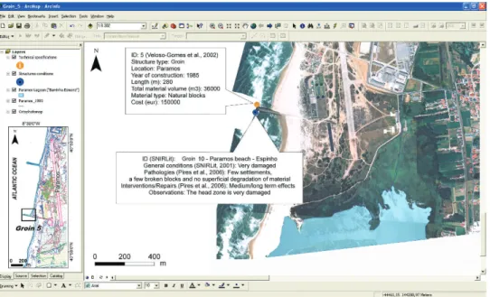
The geotechnical mapping evaluation of the groin of Paramos (Espinho shoreline) was performed according to a previously established methodology (Pires et al., 2006, 2009; Pires and Chamine´, 2007, 2009). This methodology is based on the recommen-dations and terminology of theManual of the Use of Rock in Coastal and Shoreline Engineering from CIRIA/CUR (1991) and CIRIA et al. (2007) as well as on the proposal of geologic and geotechnical characterization of rock masses by ISRM (1978a,b, 1981) and the Geological Society Engineering Work-ing Group (1995). A geotechnical datasheet was used for the recognition and visual evaluation of the rock material constituting the groin. A georeferenced GIS database for this structure was then set up using the data collected and aerial images of the area (Gon-c¸alves and Piqueiro, 2004; Cunha et al., 2006; and Pires et al., 2009). A detailed mapping of the rock blocks constituting the structure was then prepared using the aerial photographic database. Afterwards, more than 5,000 block materials on the groin’s superficial section (armor layer) were vectorized into a GIS base. Sampling along a scanline is an accurate method for the systematic collection of geological and/or geotechnical information (e.g., ISRM, 1981; Dinis da Gama, 1983, 1995; and CIRIA et al., 2007). Moreover, in several geologic-geotechnical situations
it is the easiest and fastest way to collect data. This approach allowed us to obtain thematic maps of the Paramos groin armor layer that were useful for evaluating various geotechnical parameters (ISRM, 1978b, 1981; Pires and Chamine´, 2007, 2009 [and references therein]). This assessment was also supple-mented with walkover surveys carried out to record (with the aid of photographs and high-accuracy GIS data collection system Trimble Geoexplorer GPS) not only the overall condition of the structure, including any obvious rock movements, but also changes in the groin profile, type of lithology, etc.
These visual evaluations were supported by the use of the inspection datasheet, where the most important aspects and parameters were registered, including lithology, weathering grade, petrophysical character-istics, and geomechanical features of block materials (Fookes and Poole, 1981; Lienhart, 1998). For the evaluation of the uniaxial compressive strength of rocks and materials (concrete) in the groin, the Schmidt Hammer technique was used (e.g., Katz et al., 2000; Kahraman, 2001). This methodology was further refined through the application of GIS tools (e.g., Burke et al., 2001) and was used to create thematic geotechnical zoning maps of the block groins (e.g., Zuquette and Gandolfi, 2004; Pires et al., 2009).
RESULTS AND DISCUSSION
Estimation of the rates of erosion and accretion along the study area was performed for the 9-year period using the positions of the Espinho shoreline in 1993 and 2002. According to the results obtained, zone 4 (south of Marinha groin) shows a general
trend of erosion. In agreement with this, the main accretion area is located in the north (zones 1 to 3). Figure 6 represents the beach areas that were studied and the corresponding values of erosion or accretion, as determined by the transect methods employed by
DSAS. The results indicate a general trend of erosion for the south of Espinho, with an average rate of 2.72 m/yr, whereas the mean rate of accretion estimated for the north of the study area is 3.21 m/ yr. This figure shows very well the advance of the sea in the Paramos region (south of Espinho), which is one of the most affected sectors. These results are in agreement with those estimated by Dias et al. (1994) and Dias (2005) using other methodologies and for different temporal periods. These authors report a mean erosion rate of 3.8 m/yr for the period between 1870 and 1954, a value close to that obtained in the present work for a temporal interval of just 9 years. We also estimated the areas of land loss or gain for each zone (Figure 7a). This estimation was based on polygon vectorization for each section, with subse-quent determination of the area of the polygons (Moran, 2003).
Within the Espinho coastal zone, the area of accretion has been estimated at about 60,000 m2/yr (Figure 7b), corresponding to 56 percent of the total affected area. These results are in agreement with those reported by other authors (e.g., Dias et al., 1994; Veloso Gomes et al., 2006a; and MAOTDR, 2008), who concluded that although the measures implement-ed in the Espinho area efficiently protect the northern part of the coast, they are ineffective in protecting its southern part. The displacement/settlement of blocks for the head zone of the groins is exemplified for groin 2, which shows movement or the destruction of this zone in the period ranging from 1993 and 2002 (Figure 8). Of the five groins studied, only groin 1 did not present visible settlements. Groin 4 underwent maximum change, with about 1,800 m2 of settlement
during the study period, and groin 5 had the lowest change, at 233 m2. Groins 2 and 3 present values showing approximately 900 m2of displacement.
The use of the method of transects from DSAS extension offered a flexible way to analyze Espinho coastal dynamics. Although based on just two shorelines and a short elapsed time, the method employed by the DSAS extension was powerful enough to confirm the marked evolution of the coastline during this period, clearly indicating the areas showing considerable erosion and accretion changes. Furthermore, ArcGIS embedded functions were instrumental in estimating (i) the total area affected by coastal advance and retreat and (ii) the annual average erosion and accretion rates.
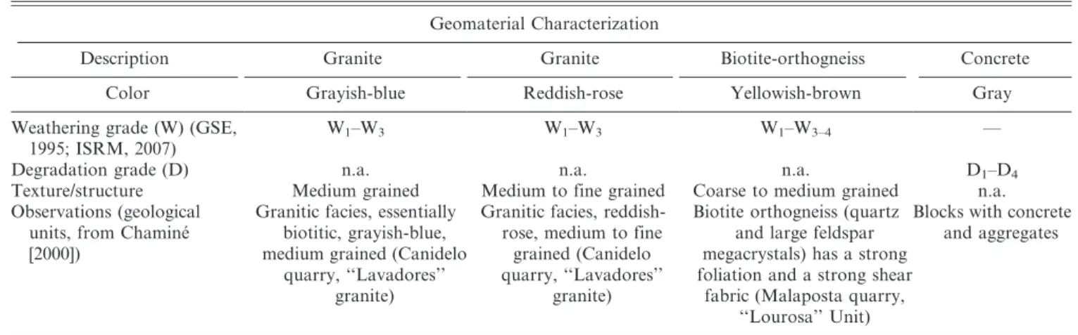
Geotechnical mapping and evaluation of the Para-mos groin involved inspection and assessment of post-construction works. Considering that the geologic nature and engineering properties of the materials used to construct coastal engineering structures are critically important to the success and longevity of the structure (e.g., Dupray, 2005; Latham et al., 2006a,b), a lithological map of the armor layer of Paramos groin was first prepared. More than 5,000 rock materials were vectorized, and the different geomaterials were identified (Table 2): for example, natural rocks (gran-ite and gneiss) and artificial materials (concrete or a mixed material [i.e., concrete+aggregates]).
The applied cartography provided an evaluation of the current condition of the structure and of the status of the revetment material. The Schmidt Hammer rebound values provided an estimate of the uniaxial compressive strength of block armor materials along the crown wall of the structure,
according to ISRM (1981). The cross-check of all geotechnical and geomechanical parameters obtained, particularly petrophysical features, weathering grade, and uniaxial compressive strength, allowed us to
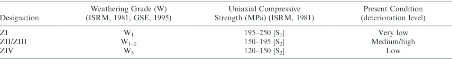
classify the Paramos armor block material in terms of its degree of deterioration (Figure 9a). Zone I (ZI) corresponds to the crown wall, which shows the maximum strength (ranging from 195 to 250 MPa).
Figure 6. DSAS application on the beach zones studied in the Espinho area: EPR (end point rate) quantification.
This zone is predominantly composed of medium- to fine-grained reddish-rose granite. Zones II (ZII, inner) and III (ZIII, head) have the same lithologic characteristics, namely medium-grained grayish-blue biotitic granite, with intermediate values of strength, ranging from 150 to 195 MPa. Finally, zone IV (ZIV) corresponds to the outer zone, with the lowest strength values (ranging from 120 to 150 MPa). This zone mainly comprises yellowish biotitic orthog-neisses with feldspar mega-crystals. Based on the described methodology, an example of the lithological characterization obtained is presented for Paramos groin (Sector 5) in Figure 9b.
Table 3 synthesizes the geotechnical features of the armor block material classification and the present
deterioration level of Paramos groin. In this case, for zones I, II/III, and IV, the deterioration levels are, respectively, very low, medium to high, and low.
The methodology used for the geotechnical mapping and assessment of the block materials from Espinho coastal protection structures proved to be an easy, fast, and economical way to assess the status of coastal protection structures (details in Pires and Chamine´ [2007, 2009]). Furthermore, this methodology provides a geological-geotechnical characterization useful for groin management. The main results of both the applied cartography developed in a georeferenced GIS base and the evaluation of the deterioration level of the groin materials reinforce the need for careful planning in this kind of work. Because the cost of production and
Figure 8. GIS project and application of DSAS extension on Espinho coastal dynamics: example of the settlement studied for groin 2.
Table 2. Geomaterials recognized along the superficial layer and studied characteristics for the five sectors.
Geomaterial Characterization
Description Granite Granite Biotite-orthogneiss Concrete
Color Grayish-blue Reddish-rose Yellowish-brown Gray
Weathering grade (W) (GSE, 1995; ISRM, 2007)
W1–W3 W1–W3 W1–W3–4 —
Degradation grade (D) n.a. n.a. n.a. D1–D4
Texture/structure Medium grained Medium to fine grained Coarse to medium grained n.a. Observations (geological
units, from Chamine´ [2000])
Granitic facies, essentially biotitic, grayish-blue, medium grained (Canidelo
quarry, ‘‘Lavadores’’ granite)
Granitic facies, reddish-rose, medium to fine grained (Canidelo quarry, ‘‘Lavadores’’
granite)
Biotite orthogneiss (quartz and large feldspar megacrystals) has a strong foliation and a strong shear
fabric (Malaposta quarry, ‘‘Lourosa’’ Unit)
Blocks with concrete and aggregates
Figure 9. (a) Armor block materials zonation, a tentative synthesis map: deterioration level and structure present condition; (b) Applied cartography from Paramos groin.
Table 3. Results of the field assays and the visual inspection.
Designation
Weathering Grade (W) (ISRM, 1981; GSE, 1995)
Uniaxial Compressive Strength (MPa) (ISRM, 1981)
Present Condition (deterioration level)
ZI W1 195–250 [S1] Very low
ZII/ZIII W1–2 150–195 [S2] Medium/high
ZIV W3 120–150 [S2] Low
transportation of the very large quantities of rock often required for coastal and shoreline structures is an essential consideration when selecting a particular design solution, it is important to establish the availability and quality control of rock materials at their point of origin or location of extraction until the project is completed. Further studies to provide more detailed information on the geological materials and the material properties in relation to the design require-ments and to apply standard test procedures to assess the quality and durability of these materials before and during construction (Pizarro et al., 2005) are in progress. At the same time, there is also a need to evaluate the structure condition after the construction (i.e., for monitoring and maintenance perspectives).
Several generations of Espinho residents have been living under the threat of coastal hazards. They have thus developed some feeling for coastal erosion, and their general opinion on the coastal defenses of the city of Espinho is that these structures are essential to holding back the sea and enlarging beach dimensions (Soares de Carvalho, 1995; EUrosion, 2004). The Espinho shoreline is a very dynamic coastal stretch, with historic and natural erosion events that may possibly become aggravated in the future, necessitating calls for careful and continued monitoring studies. Such studies may help us to avoid the undesired consequences of possible future aggravations of the erosion process.
CONCLUDING REMARKS
In conclusion, the approach adopted in this work contributes to improving our knowledge of the dynamics of the Espinho shoreline. It provides a solid base from which to easily forecast and model shoreline displacements over the years and to identify main areas of erosion/accretion.
The approach used to propose a coastal evolution for this area indicates that the recession of coastline is occurring in the form of erosive wave propagation from north to south. Along this coastal stretch there are also several hydraulic works that influence the coastal erosion process, and this can easily be shown by considering the accretion that occurs in the northern areas of obstacles (e.g., groins) and the erosion that occurs in the southern areas.
The main erosion problems, which exist in the southern area (downdrift), are due to lack of sediment transport. The most vulnerable area in terms of erosion is the urban seafront of Silvalde/Paramos (zones 4 to 8). Several large groins protect the downdrift of Paramos, and the Coastal Management Plan considers the probable retreat of this urban seafront as a future measure of managed realignment predicted for the Portuguese west coast (Taveira
Pinto, 2003). Consequently, the main problems in this stretch are due to (i) sandy coast with no natural rock protection; (ii) extended erosion problems, with the destruction of the dunes; (iii) large groins and sea walls; and (iv) the erosion existing in the urban seafront of Silvalde/Paramos (considering the retreat of this urban seafront).
In addition, according to the results obtained, a methodological characterization of the geomaterials is crucial to determine the deterioration level and the structures’ present condition. This approach uncovered the need for repair/maintenance work in some parts of the study area or for eventual changes in their design. Moreover, the GIS tools provided an easy and very useful way of handling large data sets and, most importantly, of visualizing the results in a way that facilitates the rapid perception of the status of the structures and, thus, the decision-making processes. In the present case, according to the evaluations per-formed, replacement of the primary armor layer of the head of the structures would increase the effectiveness and modification of the longevity of the structures. The results also indicate that for some of the sectors, alterations to the design of the structures would help minimize deterioration of the structures due to erosion. Figure 9a revealed that the head and inner zones have high and medium deterioration levels, respectively, and that they are significantly susceptible to waves and current events. These two zones comprise geomaterials that do not possess high compressive strength and are also subject to the currents and wave propagations, mainly from north to south, that facilitate the overall damage to the structures. For the five groins studied it was clear that the head zone has the highest level of deterioration and is the most susceptible component of the hydraulic structures, and it was also evident that during the construction and design of these structures, material selection was not based on the type of rock, quality, durability, and other characteristics, which the contractor should have taken into consideration. As a result, the methodology developed provides a geotech-nical characterization that is useful in the planning of maritime repair works. Moreover, this methodology gives further support to the importance of establishing the availability and the geotechnical quality and durability of geomaterials to be used at a particular site at the time of extraction from quarries when one is considering geoengineering design options (e.g., Lien-hart, 1998; Latham et al., 2006a,b; and Manoliu and Radulescu, 2008). On the other hand, there is also a concern for evaluating the structural condition of protection work after the construction for monitoring and maintenance.
protection structures. The costs of such structures, their expected behavior, as well as the consequences of their failure do justify on-site geotechnical inves-tigations designed to help in decision making.
This research is still in progress to provide more detailed information on the most appropriate geoma-terials (namely with regard to the rock mechanic properties required in relation to the design) and standard test procedures that are usually applied to assess quality and durability of these materials before and during construction. In this area, the illegal occupation/use of the maritime public domain is common, and there is no cartographic record of the areas of the public shoreline domain, which makes the management of these areas very complicated. To achieve results for the proposed actions or measures, it is essential to study and adequately program the interventions in the littoral region. Thus, there are three essential objectives: (1) to encourage technical scientific studies on the littoral; (2) to identify the areas at risk and take preventive measures; and (3) to protect the areas at risk.
Some proposed solutions can be accomplished through the following processes: recuperation of the dune systems; collaboration with other institutions with littoral jurisdiction; identification and definition of the areas that are more vulnerable to erosion and implementation of preventive measures; implementa-tion of the coastal defense programs; intervenimplementa-tion in priority areas (e.g., Espinho); and additional studies to find adequate interventions. The so-called hard coastal defenses are indispensable, and at the moment, there is not any plan to remove the existing groins, seawalls, and other hydraulic structures. Hence, maintenance works, or even rearrangement of the original design of the structures, is likely to continue. In addition, artificial sand nourishment operations might also be included as possible solutions to the erosion problem affecting this coastal stretch.
ACKNOWLEDGMENTS
This project was developed within the scope of a trainee period of a GIS post-graduation course (FLUP) performed by A. Pires at the Laboratory of Cartography and Applied Geology (LABCARGA-ISEP)
and GeoBioTec Centre (University of Aveiro). This work was performed with the financial support of LABCARGA-IPP-ISEP|PAD’2007/08. This research was
also funded by a doctoral scholarship from the Portuguese Foundation for Science and Technology (FCT) to A. Pires (SFRH/BD/43175/2008). We grate-fully acknowledge R. Sousa (CME), A. Mota Freitas (SOMAGUE), A. Lopes (ICSA), F. Santiago Miranda
(APDL), F. Piqueiro (FEUP), P. Freire (LNEC), F. T.
Rocha (UA), and S. Dupray (CETMEF) for useful
information; their comments greatly improved the focus of our paper. We acknowledge W. C. Haneberg, N. S. Levine, S. E. Hasan, and an anonymous referee for constructive reviews that helped to improve the clarity of the manuscript; in addition, we thank editor A. Shakoor for all the support.
REFERENCES
ARAU´ JO, M. A., 1991, Geomorphological evolution of littoral platform from Porto region: Unpublished Ph.D. Thesis, Universidade do Porto, 534 p. [in Portuguese]
ARAU´ JO, M. A., 2002, Relative sea level, diastrophism and coastal erosion: The case of Espinho (Portuguese NW coast). In Veloso Gomes, F.; Taveira Pinto, F.; and Neves, L. (Editors),
Littoral 2002, Vol. 2: Associac¸a˜o Eurocast-Portugal, Porto, Portugal, pp. 125–132.
ARAU´ JO, M. A.; GOMES, A.; CHAMINE´, H. I.; FONSECA, P. E.; GAMA
PEREIRA, L. C.; AND PINTO DE JESUS, A., 2003, Regional
geomorphology and geology from the Porto–Espinho sector (W Portugal): morphostructural implications to Genozoic sedimentary cover:Cadernos Laborato´rio Xeolo´xico de Laxe: A Corun˜a, Vol. 28, pp. 79–105. [in Portuguese]
BAILEY, C.ANDGATRELL, A., 1995,Interactive Spatial Data Analysis: Adison Wesley Longman, Essex, UK, 410 p.
BIRD, E., 1997, Coastal Geomorphology: An Introduction: John
Wiley & Sons, Ltd., Chicester, United Kingdom, 321 p. BRUMFERREIRA, A., 1983, Problems of the quaternary
geomor-phological evolution at NW Portugal:Cadernos Laborato´rio Xeolo´xico de Laxe: A Corun˜a, Vol. 5, pp. 311–329. [in Portuguese]
BURKE, R.; NAPOLEON, E.; ORMSBY, T.; GROESS, C.;ANDFEASTER,
L., 2001, Getting to Know ArcGIS Desktop: The Basics of ArcView, ArcEditor, and ArcInfo Updated for ArcGIS 9: Getting to Know series. ESRI California, Redlands, Califor-nia, USA, 550 p.
CARTER, R. G., 1988, Coastal Environments: Academic Press,
London, United Kingdom, 617 p.
CHAMINE´, H. I., 2000,Stratigraphy and structure of the Espinho-Albergaria-a-Velha metamorphic belt (Ossa-Morena Zone): geodynamic implications: Unpublished Ph.D. Thesis, Uni-versidade do Porto, 497 p. [in Portuguese]
CHAMINE´, H. I.; GAMAPEREIRA, L. C.; FONSECA, P. E.; NORONHA, F.;ANDLEMOS DESOUSA, M. J., 2003, Tectonostratigraphy of the Porto-Albergaria-a-Velha-Coimbra-Tomar Shear Zone between Central-Iberian and Ossa-Morena Zones (Iberian Massif, W Portugal): Cadernos Laborato´rio Xeolo´xico de Laxe: A Corun˜a, Vol. 28, pp. 37–78. [in Portuguese] CIRIA; CUR & CETMEF, 2007,The Rock Manual: The Use of Rock
in Hydraulic Engineering, 2nd ed.: C683. CIRIA–Centre for Civil Engineering Research, London, United Kingdom, 1200 p. CIRIA/CUR–CENTRE FOR CIVIL ENGINEERING RESEARCH, 1991,
Manual of the Use of Rock in Coastal and Shoreline Engineering: Construction Industry Research and Information Association, Special Publication 83, Centre for Civil Engineering Research and Codes Report 154, CIRIA/CUR Edition, 607 p.
CUNHA, S.; SILVA, S. R.;ANDPIQUEIRO, F., 2006, Photogrammetry in light aircraft. InProceedings of the International Calibra-tion and OrientaCalibra-tion Workshop, EuroCOW 2006, Castellde-fels, Spain, pp. 25–27.
Cientı´ficos–Turismo, Gesta˜o, Fiscalidade: Faro, Vol. 1, pp. 7–27. [in Portuguese]
DIAS, J. A.; BOSKI, T.; RODRIGUES, A.;ANDMAGALHA˜ ES, F., 2000, Coast line evolution in Portugal since the Last Glacial Maximum until present: A synthesis: Marine Geology, Vol. 170, pp. 177–186.
DIAS, J. A.; FERREIRA, O.; AND PEREIRA, A. R., 1994, Synthetic study and diagnosis of the geomorphology and the dynamic sedimentary processes between Espinho and Nazare´ coastal areas: Electronic document, available at http://w3.ualg.pt/ ,jdias/JAD/ebooks. [in Portuguese]
DINIS DAGAMA, C., 1983, Use of comminution theory to predict
fragmentation of jointed rock mass subjected to blasting. In
Proceedings of the First International Symposium on Rock Fragmentation by Blasting: Balkema, Lulea˚, Sweden, pp. 563–579.
DINIS DAGAMA, C., 1995, Aspectos geote´cnicos y de fracturacio´n
en la explotacio´n de Canteras. In Lo´pez Jimeno, C. (Editor), Cap. 10 del Manual de Rocas Ornamentales, Entorno Gra´fico. S.L., Madrid, Spain, pp. 231–246.
DUPRAY, S., 2005, Integrity of Rock Blocks for Armouring of Hydraulic Works: Towards Fullscale Test to Predict Mass Distribution Changes: Unpublished Ph.D. Thesis, Imperial College Royal School of Mines, 325 p.
EUROSION, 2004, Projecto EUrosion, ENV.B.3/SER/2001/00 30:
Electronic document, available at http://www.eurosion.org FOOKES, P.ANDPOOLE, A., 1981, Some preliminary considerations
on the selection and durability of rock and concrete materials for breakwaters and coastal protection: Quarterly Journal Engineering Geology Hydrogeology, Vol. 14, pp. 97–128. GOMES, A., 2008,Geomorphological evolution of littoral platform
between Espinho and A´gueda: Unpublished Ph.D. Thesis, Universidade do Porto, 330 p. [in Portuguese]
GOMES, A.; ASSUNC¸ A˜ O, M. A.;ANDSOUSA, A., 2006, The littoral of Oporto region (Northwest Portugal), Portugal: Coastal dynamics. In International Association of Geomorphology 6th Conference, Field Trip A1,Vol. 4: Associac¸a˜o Portuguesa de Geomorfo´logos, Lisboa, Portugal, pp. 19–23.
GOMES, A.; CHAMINE´, H. I.; TEIXEIRA, J.; FONSECA, P. E.; GAMA
PEREIRA, L. C.; PINTO DE JESUS, A.; PE´ REZ ALBERTI´, A.; ARAU´ JO, M. A.; COELHO, A.; SOARES DEANDRADE, A.;AND
ROCHA, F. T., 2007, Late Cenozoic basin opening in relation
to major strike-slip faulting along the Porto-Coimbra-Tomar fault zone (northern Portugal). In Nichols, G.; Williams, E.; and Paola, C. (Editors),Sedimentary Processes, Environments and Basins: A Tribute to Peter Friend, Special Publications of the International Association Sedimentologists (IAS),Vol. 38: Blackwell Publishing, Cambridge, UK, pp. 137–153. GOMES, N., 1977, Groin construction and design. In Semina´rio
Sobre Obras de Protecc¸a˜o Costeira (Semina´rio 210): Labor-ato´rio Nacional de Engenharia Civil, Lisboa, Portugal. [in Portuguese]
GONC¸ ALVES, J. A.AND PIQUEIRO, F., 2004, Georeferencing aerial imagery from a non-metric digital camera: application to the W Portugal coast between Figueira da Foz and Nazare´. In
Proceedings/Actas do VIII Encontro de Utilizadores de Informac¸a˜o Geogra´fica, ESIG’2004, Oeiras, Portugal, pp. 1–8. [in Portuguese]
GRANJA, H. M.; RIBEIRO, I. C.; SOARES DECARVALHO, G.;ANDMATIAS,
M. S., 1999, Some neotectonic indicators in quaternary formations of the northwest coastal zone of Portugal:Physics Chemistry Earth A, Vol. 24, No. 4, pp. 323–336.
GSE–GEOLOGICAL SOCIETYENGINEERINGGROUP WORKINGPARTY
REPORT, 1995, The description and classification of weathered
rocks for engineering purposes:Quarterly Journal Engineer-ing Geology Hydrogeology, Vol. 28, No. 3, pp. 207–242.
ISRM (INTERNATIONAL SOCIETY FOR ROCK MECHANICS), 1978a, Suggested methods for determining hardness and abrasive-ness of rocks:International Journal Rock Mechanics Mining Science Geomechanics Abstracts, Vol. 15, pp. 89–97. ISRM, 1978b, Suggested methods for the quantitative description
of discontinuities in rock masses:International Journal Rock Mechanics Mining Science Geomechanics Abstracts, Vol. 15, No. 6, pp. 319–368.
ISRM, 1981, Basic geotechnical description of rock masses:
International Journal Rock Mechanics Mining Science Geo-mechanics Abstracts, Vol. 18, pp. 85–110.
ISRM, 2007, The complete ISRM suggested methods for characterization, testing and monitoring: 1974–2006. In Ulusay, R. and Hudson, J. A. (Editors), suggested methods prepared by the Commission on Testing Methods, ISRM. Ankara, Turkey, 628 p.
KAHRAMAN, S., 2001, Evaluation of simple methods for assessing the
uniaxial compressive strength of rock:International Journal Rock Mechanics Mining Science, Vol. 38, pp. 981–994. KATZ, O.; RECHES, Z.;AND ROEGIERS, J. C., 2000, Evaluation of
mechanical rock properties using a Schmidt Hammer:
International Journal Rock Mechanics Mining Science, Vol. 37, pp. 723–728.
LATHAM, J.-P.; VAN MEULEN, J.; AND DUPRAY, S., 2006a, The
specification of armourstone gradings and EN 13383 (2002):
Quarterly Journal Engineering Geology Hydrogeology, Vol. 39, pp. 51–64.
LATHAM, J.-P.; LIENHART, D.; AND DUPRAY, S., 2006b, Rock quality, durability and service life prediction of armourstone:
Engineering Geology, Vol. 87, pp. 122–140.
LCPC (LABORATOIRECENTRAL DESPONTS ETCHAUSSE´ ES), 1989,Les Enrochements: Ministe`re de l’E´ quipement, Laboratoire Cen-tral des Ponts et Chausse´es, Paris, France, 106 p.
LIENHART, D. A., 1998, Rock engineering rating system for
assessing the suitability of armourstone sources. In Latham, J.-P. (Editor), Advances in Aggregates and Armourstone Sources, Engineering Geology Special Publication, Vol. 13: Geological Society of London, Oxford, UK, pp. 91–106. LIMA, A., 1979, A brief history of Espinho: Espinho Boletim
Cultural, Vol. 1, pp. 11–44. [in Portuguese]
LIMA, A., 1982, Sea invasions at Espinho: Espinho Boletim Cultural, Vol. 15/16, pp. 333–341. [in Portuguese]
LOPES, J. N. T., 1995, The birth of the urban agglomeration,
Espinho in the second half of the XIX century: Actas 1u Encontro de Histo´ria Local, Caˆmara Municipal de Espinho: pp. 101–105. [in Portuguese]
MANOLIU, I.ANDRADULESCU, N. (Editors), 2008, Education and
Training in Geo-Engineering Sciences: Soil Mechanics and Geotechnical Engineering, Engineering Geology, Rock Me-chanics: Routledge, Taylor and Francis Group, Constantza, Romania, 526 p.
MAOTDR (MINISTE´ RIO DO AMBIENTE DO ORDENAMENTO DO
TERRITo´RIO E DODESENVOLVIMENTOREGIONAL), 2008,Litoral 2007–2013: Avaliac¸a˜o dos Planos de Ordenamento da Orla Costeira e Propostas de Actuac¸a˜o: MAOTDR, Lisboa, Portugal, 190 p.
MCCLEESE, W. F., 2000, REMR Program Overview and Guide: Repair, Evaluation, Maintenance, and Rehabilitation Research Program: Geotechnical Associates Networks, LLC, Engineer Research and Development Center, U.S. Army Corps of Engineers, Vicksburg, Missı´ssippi, USA.
MORAN, C. A., 2003,Spatio-Temporal Analysis of Texas Shoreline Changes Using GIS Technique: Unpublished M.Sc. Thesis, University of Texas, 117 p.
MOTAOLIVEIRA, I. B.ANDMARTINS, L. M., 1991, Espinho coastal
Association of Hydric Resources, APRH, Vol. 12, No. 1/2, Lisbon, Portugal, pp. 71–88. [in Portuguese]
MOTAOLIVEIRA, I. B.; TRIGOTEIXEIRA, A.;ANDSANCHES DOVALLE,
A., 2000, West coast of Portugal: A comparison between project predictions and reality. In27th International Confer-ence on Coastal Engineering, ICCE’2000, Sydney, Australia. ORTIGA˜ O, R., 1876,Portugal beaches: Livraria Cla´ssica Editora,
Lisboa, Portugal, 275 p. [in Portuguese]
PDM (PLANO DIRECTOR MUNICIPAL), 2004, Plano Director Municipal da Caˆmara Municipal de Espinho: Electronic document, available at http://www.cm-espinho.pt
PERDIGA˜ O, F., 1931, The coastal works on beaches:1uCongresso de Engenharia Civil: Se´rie de artigos do jornal ‘‘Defesa de Espinho,’’ Fevereiro a Abril de 1976. [in Portuguese] PIRES, A., 2005, Systematic monitoring programme of coastal
protection works with a geoengineering perspective: the case study of the Espinho groins: Unpublished Graduation Engineering Thesis, Institute of Engineering, ISEP, Porto, 202 p. [in Portuguese]
PIRES, A., 2007,Geoengineering and inspection of hydraulic works, from the source (quarry) to the coastal protection structure: Unpublished Master Engineering Thesis, University of Aveiro, 268 p. [in Portuguese]
PIRES, A. AND CHAMINE´, H. I., 2007, Geotechnical mapping
evaluation of rock groynes in Espinho area (NW Portugal). In Ribeiro e Sousa, L.; Olalla, C.; and Grossmann, N. F. (Editors), Proceedings of the 11th ISRM Congress of the International Society for Rock Mechanics.Vol. 1: Francis & Taylor Group, Lisbon, Portugal, pp. 307–310.
PIRES, A. AND CHAMINE´, H. I., 2009, Geoengineering field
techniques for rock characterization of coastal protection structures. In Hudson, J. A.; Tham, L. G.; Feng, X.-T.; and Kwong, A. K. (Editors),Proceedings of SINOROCK’2009, ISRM International Symposium on Rock Mechanics, Rock Characterization, Modelling and Engineering Design Methods: University of Hong Kong, Hong Kong, China, pp. 262–266. PIRES, A.; CHAMINE´, H. I.; GOMES, A.; PIQUEIRO, F.; MIRANDA, F. S.; AND ROCHA, F. T., 2009, Cartography and assessment of
hydraulic structures from Espinho coastal area (NW Portugal) using high-resolution aerial imagery surveys and a GIS interactive base:Journal Coastal Research, Vol. SI 56, pp. 1572–1576. PIRES, A.; SANTIAGOMIRANDA, F.; GOMES, A.;ANDCHAMINE´, H. I.,
2006, Mapping and assessment of groins from the Espinho area: a methodological proposal in geotechnical perspective: In
Proceedings from the National Congress on Geotechnics, Portuguese Society of Geotechnics, Vol. 1: SPG, Lisbon, Portugal,pp. 165–174. [in Portuguese]
PIRES, A.; VINAGRE, A.; GOMES, A.;ANDCHAMINE´, H. I., 2007, GIS
application to landscape management of the Espinho urban area: a prediction based on historical analysis of coastal dynamics:Portuguese Association of Geomorphology Publica-tions: APGeom, Vol. 5, pp. 281–291. [in Portuguese] PIZARRO, S.; GOMES, L.; DINIS DA GAMA, C.; LOPES, A.; AND
CHAMINE´, H. I., 2005, Application of optical systems to the
evaluation of size distributions in granitic rocks for aggre-gates production: Malaposta Quarry case study (NW Portugal): Cadernos Laborato´rio Xeolo´xico de Laxe: A Corun˜a, Vol. 30, pp. 57–73. [in Portuguese]
SANTOS, J.; NEVES, M.;AND SILVA, L. G., 2003, Rubble-mound
breakwater inspection in Portugal: InProceedings of Costal Structures 03 Conference, Melby, J. F. (Editor), ASCE Portland, Oregon, USA, pp. 249–261.
SILVA, L. G., 1996, Systematic observation of rubble mound
breakwaters in the portuguese coast: Journal of the Portu-guese Association of Hydric Resources (APRH), Vol. 17, No. 1, pp. 13–24. [in Portuguese]
SNIRLIT, 2002,National Information System of Littoral Resources of the Water Institute: Electronic document, available at http://geo.snirh.pt/snirlit/site/consulta.php
SOARES DECARVALHO, G., 1995, Geological story of the Espinho
coastal zone in the past 30,000 years:Actas 1uEncontro de Histo´ria Local: Caˆmara Municipal de Espinho, pp. 155–168. [in Portuguese]
SOMAGUE, 1980,Defence works of Espinho region, Pre-project assessment and working plan: National Harbour Authority: DGP-Direcc¸a˜o Geral de Portos. Unpublished technical report. [in Portuguese]
TAVEIRAPINTO, F., 2003,Good Practices in Coastal Zone Manage-ment and Coastal Defence: International Workshop, 7–8 June 2002. FCT/EUCC/IHRH/FEUP, Porto, Portugal, 109 p. TEIXEIRA, C.; PERDIGA˜ O, J.; AND ASSUNC¸ A˜ O, C. T., 1962,
Explanation notice from the 13-A sheet (Espinho), Geological Map of Portugal, scale 1:50000: Geological Services of Portugal, Lisboa, Portugal, 28 p. [in Portuguese]
THIELER, E. R. AND DANFORTH, W., 1994, Historical shoreline mapping (II): Application of the digital shoreline mapping and analysis systems (DSMS/DSAS) to shoreline change mapping in Puerto Rico:Journal Coastal Research, Vol. 10, No. 3, pp. 600–620.
THIELER, E. R.; HIMMELSTOSS, E.; AND MILLER, T., 2005, User Guide & Tutorial for the Digital Shoreline Analysis System (DSAS) Version 3.2. Extension for ArcGIS v.9.0: Part of USGS Open-File Report 2005–1304. 33 p.
TRIGOTEIXEIRA, A., 2003, Mapping land at risk. Evolution of the
Portuguese coast between Espinho and Cape Mondego (1970–1996): Good Practices in Coastal Zone Management and Coastal Defence: FCT/EUCC/IHRH/FEUP, Porto, Portugal, pp. 51–63.
USACE (U.S. ARMYCOASTALENGINEERINGRESEARCH), 1990,Side Scan Sonar for Inspection of Costal Structures, REMR Technical Note CO-SE-1.4: U.S. Army Coastal Engineering Research Center, U.S. Army Corps of Engineers WES. USACE, 1995,Coastal Engineering Manual. Coastal Geology: U.S.
Army Corps of Engineers, Washington, DC, EM 1110-2-1810. USACE, 2002,Engineering and Design, Hydrographic Surveying, EM 1110-2-1003: U.S. Army Coastal Engineering Research Center, Department of the Army.
VELOSOGOMES, F.; BARROCO, A.; RAMOSPEREIRA, A.; SOUSAREIS,
C.; CALADO, H.; GOMESFERREIRA, J.; CONCEIC¸ A˜ OFREITAS, M.; AND BISCOITO, M., 2006a, Basis for a national strategy for integrated coastal zone management in Portugal: National Working Group designated by the Ministry for Environment, Spatial Planning and Regional Development (MESPRD), Version for public discussion, 23 January 2006, 62 p. [in Portuguese]
VELOSOGOMES, F.; TAVEIRA-PINTO, F.; BARBOSA, J.; NEVES, L.;AND
COELHO, C., 2002, High risk situation in the NW Portuguese Coast: Douro River, Cape Mondego. InProceedings of the 6th International Symposium LITTORAL 2002, Eurocoast, Porto, Portugal, pp. 411–421.
VELOSOGOMES, F.; TAVEIRA-PINTO, F.; NEVES, L.;ANDBARBOSA, J.,
2006b, Pilot site of River Douro, Cape Mondego and case studies of Estela, Aveiro, Caparica, Vale do Lobo and Azores:
EUrosion, A European Initiative for Sustainable Coastal Erosion Management: EUROSION-PORTUGAL, 316 p.
VELOSO GOMES, F.; TAVEIRA PINTO, F.; NEVES, L.; AND PAIS
BARBOSA, J., 2003, Characterization of the west coast of
Portugal. Stretch River Douro (Porto), Cape Mondego:Good Practices in Coastal Zone Management and Coastal Defence: FCT/EUCC/IHRH/FEUP, Porto, Portugal, pp. 29–50. ZUQUETTE, L. V.ANDGANDOLFI, N., 2004,Geotechnical

![Table 1. Summary of the main characteristics of groins in the Espinho region (compiled data from SOMAGUE [1980] and Veloso Gomes et al](https://thumb-eu.123doks.com/thumbv2/123dok_br/16778629.748560/7.918.96.847.124.316/table-summary-characteristics-groins-espinho-compiled-somague-veloso.webp)