1 Istituto Italiano di Paleontologia Umana – IIPU (Italian Institute of Human
Paleontology) & Universidade Federal do Paraná – UFP (Federal University of Paraná) Instituto Politécnico de Tomar – Universidade de Trás-os-Montes e Alto Douro
(Departamento de Geologia da UTAD – Departamento de Território, Arqueologia e Património do IPT)
Master Erasmus Mundus em
QUATERNARIO E PRÉ-HISTÓRIA
Dissertação final:
The Lower Paleolithic and the Lithic
Materials of the Dauqara Formation,
Jordan
Aldo Malagó
Orientadores: Fábio Parenti1
Júri: Marta Arzarello, Carlo Peretto, Jose Martinho Lourenço, Silverio Figueiredo, Gema Chachon, Antony Borel, François Semah, Carlos Lorenzo, Robert Sala
II
Abstract
The lower Paleolithic of the Levant is known through sites like Ubeidiya in Israel, El Kowm in Syria and Bordj Kinnarit in Lebanon. Lithic assemblages from Mode 1 and Mode 2 industries are found in these sites but in Jordan the works about the lower Paleolithic are scarce and the archaeological record for these industries is poorly understood.
The aim of this thesis is to verify the spatial distribution of archaeological materials of sites 330, 334 Inferior and 334 Superior in Sukhne, Jordan, through the use of GIS software and statistical methods as well as through analysis of variance and qualitative methods to compare the lithic assemblages of these sites to confirm their
typology and in search for patterns that might indicate fluvial interference in the site’s
artifacts. Before that, the geology of the area is visited as well as the hypothesis for the paleoenvironment of Jordan during the lower Paleolithic, the tectonic movements that are
active in the area and the site’s stratigraphy.
The results of this study show that spatial distribution in the worked sites is not random, contrary that would be expected from heavy interference from water, that the qualitative features of the lithic assemblages are also not random nor show specific patterns attributed to water flow and that the lithic industry is compatible with Mode 2 industries in the middle stage of reduction.
Keywords: Lower Paleolithic, Jordan, Lithics, Acheulean, Spatial Distribution, Analysis of Variance
Resumo
O Paleolítico inferior do Levante é conhecido através de sítios como Ubeidiya em Israel, El Kowm na Síria e Bordj Kinnarit no Líbano. Coleções líticas do Modo 1 e Modo 2 são encontrados nesses sites, mas na Jordânia os trabalhos sobre o Paleolítico inferior são escassos e o registro arqueológico para estas indústrias é pouco compreendido.
O objetivo deste trabalho é verificar a distribuição espacial dos materiais arqueológicos de sítios 330, 334 Inferior e 334 Superior em Sukhne, Jordânia, através da utilização de software GIS e métodos estatísticos, bem como através de análise de variância e métodos qualitativos para comparar as coleções líticas destes sítios para confirmar a sua tipologia e na busca de padrões que podem indicar interferência fluvial em artefatos do sítio. Antes disso, a geologia da área é visitada, bem como as hipóteses para o paleoambiente da Jordânia durante o Paleolítico inferior, os movimentos tectônicos que estão ativos na área e a estratigrafia do local.
Os resultados deste estudo mostram que a distribuição espacial nos sítios trabalhados não é aleatória, contrariamente do que seria esperados de grande interferência fluvial, que as características qualitativas da coleção líticas também não são aleatórios nem mostram padrões específicos atribuídos ao fluxo de água e que a indústria lítica é compatível com a indústria lítica Modo 2 no estágio intermediário de redução.
III
IV
Acknowledgments
This thesis wouldn’t be possible without the support of many people, especially
Professors Fábio Parenti, Astolfo G. M. Araujo, Walter A. Neves and Maria M. M.
Okumura, thanks for their past and present advice, guidance and help. Many thanks to
Abebe M. Taffere for his company and advice these last two years. Also thanks to Silvana
dos Santos for her support and incentive and for Yousef Al-Shishani and Gabriela Sartori
Mingatos for their help during fieldwork. Many thanks to professors Mila S. de Abreu,
Luiz Oosterbeek, Agda Vialou and Denis Vialou for all their help and for their helpful
commentaries.
Also thanks to the European Union's Erasmus Mundus for providing me with the
financial means to complete this project and lastly thanks to UTAD, IPT and the MNHN,
their staff, the people and professors who helped me through this journey.
V
Table of Contents
Introduction ... 1
Jordan in the Early Pleistocene ... 4
Geology and Topography ... 4
The Studied Sites ... 11
Literature Review ... 11
Location and Materials ... 20
Site Stratigraphy ... 24
Methods ... 29
Data Gathering ... 29
Data Analysis ... 38
The Process of Spatial Analysis ... 38
The Process of Statistical Analyses ... 44
The Process of Qualitative Analysis ... 47
Results ... 50
Spatial Analyses ... 50
Quantitative Analyses ... 53
Site 330 ... 53
Site 334 Inferior ... 70
Site 334 Superior ... 85
Site Comparisons ... 96
Analysis of Variance ... 112
Typology or Qualitative Analyses ... 117
The 334 Inferior Collection ... 117
The 330 Collection ... 121
Discussion ... 124
VI
Bibliography ... 130
List of Figures
Figure 1 - World Plates (Source: Watson J., 2011) ... 4Figure 2 – Major Structural Features of Jordan (Source: Al-Diabat, 2012) ... 6
Figure 3 - Five physiographic provinces of Jordan. (Source: Al-Nahar & Clark, 2009; Adams, 2008; both based on Bender, 1975) ... 7
Figure 4 - Location of Sukhne in Jordan ... 20
Figure 5 - Location of the studied sites ... 21
Figure 6 - Detail of the location of sites 334 ... 22
Figure 7 - Detail of the location of sites 330 ... 23
Figure 8 - Site 334 Inferior Horizons ... 24
Figure 9 - Site 334 Superior horizons and exploratory trench ... 25
Figure 10 - Site 330 horizons ... 26
Figure 11 – Site 330 Section (Source: Field Drawing by M. Wilson in Parenti et al., 1997) ... 27
Figure 12 - Site 334 inferior section ... 29
Figure 13 - Detail of the Section and of stake 5 of site 334 inferior ... 30
Figure 14 - QGIS Main Screen ... 43
Figure 15 – Vertical distribution of artifacts by three major categories – Site 334 Inferior ... 50
Figure 16 – Vertical distribution of artifacts in high density zone by weight - Site 334 Inferior ... 50
Figure 17 – Vertical distribution of artifacts by three major categories – Site 334 Superior ... 51
Figure 18 - Vertical distribution of artifacts by three major categories – Site 330 ... 51
Figure 19 - Vertical distribution of flakes by weight – Site 330 ... 52
Figure 20 - Vertical distribution of core tools by weight – Site 330 ... 52
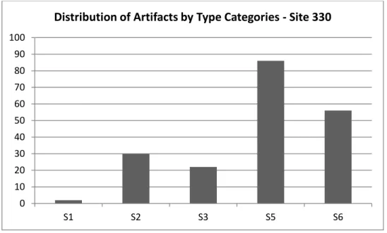
Figure 21 - Frequencies of artifacts by Class Categories in absolute numbers – Site 330 ... 54
Figure 22 – Distribution of flakes by Type in absolute numbers – Site 330 ... 55
VII
VIII
Figure 48 - Frequency of core tools by cortical coverage in absolute numbers– Site 334
Inferior ... 79
Figure 49 - Frequency of flakes by cortical coverage in absolute numbers - Site 334 Inferior ... 79
Figure 50 - Distribution of flakes by type of striking platform in absolute number – Site 334 Inferior ... 80
Figure 51 - Distribution of artifacts by number of detachment angle in absolute number – Site 334 Inferior ... 81
Figure 52 - Frequency of flakes by maximum length in absolute numbers– Site 334 Inferior ... 83
Figure 53 - Frequency of core tools by maximum length in absolute numbers– Site 334 Inferior ... 84
Figure 54 – Frequencies of core tools by Type categories in absolute numbers– Site 330 ... 85
Figure 55 - Distribution of artifacts by class categories in absolute number – Site 334 Superior ... 86
Figure 56 - Distribution of flakes by type categories in absolute numbers – Site 334 Superior ... 87
Figure 57 - Distribution of flakes by number of scars in the dorsal surface in absolute numbers – Site 334 Superior ... 88
Figure 58 - Distribution of flakes by weight in absolute numbers – Site 334 Superior . 89 Figure 59 - Boxplot graph of weight of flakes– Site 334 Superior ... 90
Figure 60 – Frequency of flakes by cortical coverage - Site 334 Superior ... 91
Figure 61 - Distribution of flakes by number of striking platforms in absolute number platform – Site 334 Superior ... 92
Figure 62 - Distribution of artifacts by detachment angle in absolute number – Site 334 Superior ... 93
Figure 63 - Boxplot graph of flakes maximum length of flakes – Site 334 Superior .... 94
Figure 64 - Maximum length of flakes by absolute numbers – Site 334 Superior ... 95
Figure 65 - Comparison between the three sites by class categories... 96
Figure 66 - Comparison between three sites by type categories ... 97
Figure 67 - Comparison of flakes by weight in the three sites ... 98
Figure 68 - Comparison by weight of core tools ... 100
IX
Figure 70 - Comparison between three sites by number of negative bulbs ... 102
Figure 71 - Comparison between three sites by integrity categories ... 103
Figure 72 - Comparison between three sites by Fiche Typologie Africaine ... 104
Figure 73 - Comparison between three sites by number of striking platforms ... 105
Figure 74 – Flake comparison of the three sites by detachment angle ... 106
Figure 75 – Comparison by cortical coverage of core tools ... 107
Figure 76 - Comparison between the three sites by cortical coverage of flakes ... 107
Figure 77 - Comparison of types of core tools at the three sites ... 108
Figure 78 - Comparison of frequencies of core tools by maximum length ... 109
Figure 79 - Comparison between the three sites by maximum length of flakes ... 110
Figure 80 – Negatives of artifact 09 of Site 334 Inferior ... 117
Figure 81 - Negatives of artifact 86 of Site 334 Inferior ... 118
Figure 82 - Negatives of artifact 108 of Site 334 Inferior ... 118
Figure 83 - Reduction sequence of artifact 08 of Site 334 Inferior ... 119
Figure 84 – Flake 142 of Site 334 Inferior ... 120
Figure 85 – Eighteen flakes of Site 334 Inferior ... 120
Figure 86 - Chopper artifact 962 of Site 330 ... 121
Figure 87 - Artifact 984, a core, and striking directions - Site 330 ... 122
Figure 88 – Artifact 1190 of Site 330, a chopper with the tip covered in soot ... 122
Figure 89 - Nine cores of Site 330 ... 123
List of Tables
Table 1 – Randomness of artifact distribution in the analyzed sites ... 53Table 2 - Frequencies of artifacts by class categories – Site 330 ... 54
Table 3 - Frequencies of flakes by type categories – Site 330 ... 54
Table 4 - Descriptive analysis of the weight of Core Tools – Site 330 ... 55
Table 5 - Frequencies of core tools by weight (g) – Site 330 ... 56
Table 6 - Descriptive analysis of weight of flakes – Site 330 ... 57
Table 7 - Frequencies of flakes by weight (g) – Site 330 ... 58
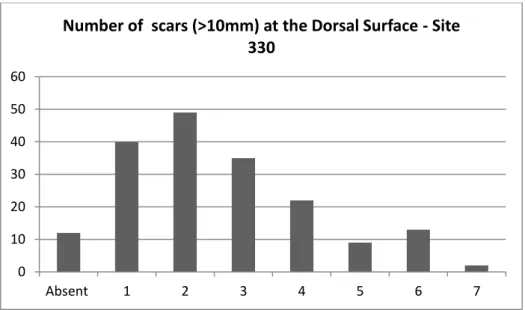
Table 8 - Number of scars in the dorsal surface of flakes – Site 330 ... 59
Table 9 - Frequency of core tools by number of negative bulbs – Site 330 ... 60
Table 10 - Integrity classification of flakes – Site 330 ... 61
Table 11 - Frequency of Choppers by Fiche Typologie Africaine – Site 330 ... 61
X
Table 13 - Frequency of flakes by type of striking platforms – Site 330 ... 63
Table 14 - Frequencies of flakes by cortical coverage – Site 330 ... 64
Table 15 - Frequencies of Core tools by cortical coverage – Site 330 ... 65
Table 16 - Descriptive analysis of core tools by maximum length – Site 330 ... 65
Table 17 - Frequencies of core tools by maximum length (mm) – Site 330 ... 66
Table 18 - Descriptive analysis of maximum length of flakes – Site 330 ... 67
Table 19 - Frequencies of flakes by maximum length – Site 330 ... 68
Table 20 - Frequencies of core tools by Type categories – Site 330 ... 69
Table 21 - Frequencies of artifacts by class category – Site 334 Inferior ... 70
Table 22 - Frequencies of flakes by type categories – Site 334 Inferior ... 71
Table 23 - Frequencies of core tools by weight – Site 334 Inferior ... 72
Table 24 - Descriptive analysis of flakes by weight– Site 334 Inferior ... 74
Table 25 - Descriptive analysis of flakes by weight– Site 334 Inferior ... 75
Table 26 - Table of flakes by integrity classification – Site 334 Inferior ... 76
Table 27 - Number of scars at the dorsal surface of flakes – Site 334 Inferior ... 76
Table 28 - Frequencies of core tools by number of negative bulbs – Site 334 Inferior . 77 Table 29 - Fiche Typologie Africaine – Site 334 Inferior ... 78
Table 30 - Frequency of core tools by cortical coverage - Site 334 Inferior ... 79
Table 31 - Frequency of flakes by cortical coverage– Site 334 Inferior ... 79
Table 32 - Frequency of raw materials – Site 334 Inferior ... 80
Table 33 - Distribution of flakes by type of striking platform – Site 334 Inferior ... 80
Table 34 - Detachment angles of flakes – Site 334 Inferior ... 81
Table 35 - Descriptive analysis of maximum length of flakes – Site 334 Inferior... 81
Table 36 - Descriptive analysis of maximum length of core tools– Site 334 Inferior ... 82
Table 37 - Frequency of core tools by maximum length– Site 334 Inferior ... 82
Table 38 - Frequency of core tools by maximum length– Site 334 Inferior ... 83
Table 39 - Frequencies of core tools by Type categories – Site 330 ... 84
Table 40 - Frequencies of artifacts by class categories – Site 334 Superior ... 85
Table 41 - Frequencies of flakes by type – Site 334 Superior ... 86
Table 42 - Frequencies of integrity categories – Site 334 Superior ... 87
Table 43 – Frequencies of flakes by number of scars in the dorsal surface – Site 334 Superior ... 87
XI
Table 45 - Frequencies of flakes by weight – Site 334 Superior ... 88
Table 46 - Descriptive analysis of the weight of flakes – Site 334 Superior ... 89
Table 47 - Frequency of artifacts by FTA – Site 334 Superior ... 90
Table 48 - Frequency of flakes by cortical coverage - Site 334 Superior ... 90
Table 49 - Frequency of core tools by cortical coverage - Site 334 Superior ... 91
Table 50 - Frequency of flakes by number of striking platform – Site 334 Superior .... 91
Table 51 - Frequency of artifacts by detachment angle – Site 334 Superior ... 92
Table 52 - Descriptive analysis of maximum length of flakes – Site 334 Superior ... 93
Table 53 - Frequencies of flakes by maximum length – Site 334 Superior ... 94
Table 54 - Maximum length of core tools – Site 334 Superior ... 95
Table 55 – Core tools by type – Site 334 Superior ... 95
Table 56 - Comparison between the sites about class categories ... 96
Table 57 - Comparison between the three sites by flake type categories ... 97
Table 58 - Flake distribution by stage of biface reduction ... 98
Table 59 - Comparison of flakes weight in the three sites ... 99
Table 60 - Comparison of weight of core tools in the three sites ... 99
Table 61 - Comparison by number of scars in the dorsal surface ... 100
Table 62 - Comparison by number of negative bulbs ... 101
Table 63 - Comparison by integrity categories ... 102
Table 64 - Comparison between three sites by Fiche Typologie Africaine ... 103
Table 65 - Comparison by Striking Platform ... 104
Table 66 - Comparison by Detachment Angle ... 105
Table 67 - Comparison of cortical coverage of core tools in the three sites ... 106
Table 68 - Comparison of cortical coverage of flakes in the three sites ... 107
Table 69 - Comparison of frequencies of core tools by type of core ... 108
Table 70 - Comparison of frequencies of core tools by maximum length ... 109
Table 71 - Comparison of Frequencies of flakes by maximum length ... 110
Table 72 - Comparison by material composition ... 111
Table 73 – ANOVA table for weight of flakes ... 112
Table 74 – Games-Howell post hoc test for weight of flakes ... 112
Table 75 - ANOVA table for weight of core tools ... 112
Table 76 - Tukey’s Honest Significant Difference test for weight of core tools... 113
Table 77 - ANOVA table for number of scars at dorsal face ... 113
XII
Table 79 - ANOVA table for striking platform ... 114
Table 80 - Tukey’s test for striking platform ... 114
Table 81 - ANOVA table for maximum length of flakes ... 115
Table 82 - Games-Howell test for maximum length of flakes ... 115
Table 83 - ANOVA table for maximum length of core tools ... 115
Table 84 - Tukey’s test for maximum length of core tools ... 116
Table 85 - ANOVA table for maximum linear dimension ... 116
1
Introduction
The Out of Africa theory postulates that hominins developed in Africa, possibly in the territory that is currently Ethiopia or Tanzania and eventually spread out of Africa to all the continents. This theory is largely supported by fossil remains of early hominins but also by lithic assemblages, Oldowan and Acheulean, and their chronology and spread through time to other parts of the world, from 2.6 or 2 million years ago for Oldowan and 1.7 million years ago for Acheulean. Despite the multiple paths theorized for the Out of Africa dispersion, the path with the oldest evidence is through the Levant, crossing the Sinai Peninsula and upwards towards the Caucasus and eastwards to Asia. While the climate during the lower Paleolithic in the region was radically different from the deserts and xeric shrublands that dominate northern Africa, Sinai and much of the east bank of the Jordan and the Levant in modern times (Copeland, 1998), aridity had already begun to crept in these regions and the most abundant and fertile valleys would be in the wadis of Jordan, on the western parts of the current country and in the territory of Israel (Al-Nahar & Clark, 2009) while in the east, where the Arabian Desert and East
Saharo-Arabian xeric shrublands now are, steppes dominated the landscape, albeit less fertile than the water rich ecosystem of the west.
The Levant was then the natural land bridge outside of Africa and a gateway for Europe and Asia during the Lower Paleolithic, a corridor of water rich and fertile valleys that was narrowing as climate changed. As with the Oldowan and Acheulean evidence for the Out of Africa hypothesis, there is archaeological evidence found in sites in the Levant to sustain the Out of Africa hypothesis. Sites that have Oldowan or Early Acheulean (or sometimes as the authors prefer to refer to them, Mode 1 and Mode 2) lithic assemblages were systematically studied for years now (Bar-Yosef & Goren-Inbar, 1993; Le Tensorer, von Falkenstein, Le Tensorer, Schmid, & Muhesen, 2011; Jagher & Le Tensorer, 2011).
These sites have a well-defined and studied stratigraphic context and in some cases even hominin fossils, but the same can’t be said of Jordan, a country that is situated
in the Levantine “corridor”. Jordan, be it by lack of investment or interest, has long been
2
Adams, 2008; Al-Nahar & Clark, 2009). Under Besançon and Baubron, the first systematic studies of the lower Paleolithic of the area were undertaken in the nineteen-eighties. Even though the main objectives were geological studies, formations with
visible lithic materials were recorded and reported. Nevertheless, the Early Paleolithic of Jordan, situated in one of the theorized first migratory roads out of Africa remains largely unknown.
Following the discovery of the studied sites in the Dauqara formation and the characterization of the later, in the nineteen-eighties, by the expeditions headed by Besançon and Baubron, in the nineteen-nineties a group of Italo-Jordanian expeditions set out to clear some of the shroud that clouded this specific point and place of the archaeological record by identifying, assessing, recording and analyzing prehistoric sites in Jordan. From 1994 to 2001 these expeditions were headed by Gaetano Palumbo and Zeidan Kafafi but from 1996 onwards they were headed by Fábio Parenti. These expeditions found that the Dauqara formation, north of Sukhne, potentially had material dating back to the Acheulean and the discovery of animal fossils in one of the sections brought the possibility of relative dating to the sites. The Dauqara formation is, however, a sedimentary polygenic and polycyclic formation. There are clear signs of water presence in the stratigraphic layers and of riverbeds, but the extent to which it interfered in the archaeological material is unknown. Thus a conundrum about the contemporaneity of the artifacts and the fossil remains found within became evident.
The topography of the studied area is markedly rugged, with the Zarqa River and ancient wadis carving valleys in the limestone hills. Modern precipitation is low and the
climate is arid, but during the Pleistocene the conditions were more humid and the ancient and now dried wadis ran with fresh water. The Dauqara formation and the sites lie in a hilly plain where the Zarqa River meets one of its tributaries, the Dhulail. The elevation is lower compared to neighboring hills, but the terrain is still rugged enough to form naturally occurring sections and hills, but eroded enough to allow small plains to exist.
3 can be found in the distribution of lithic characteristics, qualitatively or spatially. At first the situation of each site and their history will be reviewed as well as their geological characteristics. Macro stratigraphic layers and features were assessed in this work and
4
Jordan in the Early Pleistocene
Geology and Topography
Covering an area of 96,500 km², the Hashemite Kingdom of Jordan is located in the north-western part of the Arabian Plate (Figure 1) and is separated from the African Plate by the Jordan Rift Valley, a rift system that goes from Aqaba, in the south of Jordan, up to the Dead Sea and follows the Jordan Valley to the north. Theorized to be a part of the Great Rift Valley, it would follow through the Red Sea all the way south to Ethiopia and Tanzania, eventually ending in Mozambique. The tectonics of both plates point to the African plate going north while the Red Sea widens, meaning the Jordan Valley and the rift are also getting wider, deeper and are more so now than they were two million years ago (Burdon, 1959).
Figure 1 - World Plates (Source: Watson J., 2011)
5 Mediterranean Sea might have been linked with the Red Sea through the Gulf of Aqaba, the Wadi Araba and the Beisan Depression (Ababsa, 2013). More recently, during the Quaternary, starting 2.588 million years ago, the Rift Valley and its extensions, the Azraq
– Wadi Sirhan and al-Jafr depressions, had sediments and other detritus already being transported into these regions (Ababsa, 2013).
Rifting in the Jordan Rift Valley began around 25 to 30 million years ago, during the transition of the Oligocene to the Miocene periods (Adams, 2008). Subsidence in the basin of the Dead Sea began in the Pliocene and came with deposits of evaporates and marine sequences (Ginzber & Kashai, 1981), a process that is still in course to this day. The rifting dynamics in Jordan play a crucial role in the lacustrine and fluvial systems, past and present, and in the process of sediment deposition of the Rift Valley in Jordan. This sedimentary deposition in the Rift Valley accelerated during the Pleistocene as continental fluvial and lacustrine influence moved large quantities of sediments by eroding the steep valley flanks that surrounds the depression (Adams, 2008).
During the Pleistocene the depressions created by the rifts were covered by fresh and briny water lakes, with isochronous fluviatile conglomerates spreading along wide areas in the mountain ridges and eastern slopes of the east side of the Wadi Araba – Jordan Rift system (Jreisat, 1995). Wadis such as Hisma and Wadi Hasa, associated with major lateral faults, as well as Lake Tiberias, in Ubeidiya, foster the most important hominid occupations in the region. In the north, in the Tabaq Fahl region, the landscape was heavily influenced by tectonic activity, with phases of uplift movements from the Rift Valley leading to incisions in the landscape and the development of ancient wadis. These
wadis underwent extensive alluviation during the filling of Lake Lisan in the Late Pleistocene (Adams, 2008).
Extensive volcanic activity is associated with rifting, beginning in the early Miocene and continuing to recent times, with phases of activity dating to 10 million years ago and visible in the outcrops of basalt and basaltic formations, like the Dauqara formation in the Western Highlands / Upper Zarqa region as well as extruded outcrops along major faults like the ones in Dhra and Wadi Hisma (Adams, 2008).
6
springs (Salameh, 1985). These springs are of critical importance, acting as conduits for the released groundwater, sustaining a more stable water source. Its catch system is more shielded from seasonality and aridity in a region where periods of aridity affected the
region ever since the Early Pleistocene. The final result is that since the Calabrian period the abundance of water in the Jordan Valley, and to some extent in the neighboring faults, made it a corridor for migration from Africa to Asia and Europe (Adams, 2008), making it one of the prime land routes for hominins migrating from Africa.
7 During the Early Pleistocene, the territory of what is now Jordan was radically different than the encroaching arid that dominates the east bank of the Jordan River. Using the proposed model for the physiographic regions of Jordan (Figure 3) of Bender (1975)
as a basis for understanding the region, some authors established that the area was dominated in the western highlands by swamps and lakes for the most of the Pleistocene, with most sites during that age appearing associated with lakeshore environments while to the east, in the Central Plateau, steppe and grassland savannahs dominated the landscape (Adams, 2008; Al-Nahar & Clark, 2009).
Figure 3 - Five physiographic provinces of Jordan. (Source: Al-Nahar & Clark, 2009; Adams, 2008; both
8
In arid and semiarid conditions, human occupation is synonymous with the presence of water. Ground water and rain occurrence happens at the mercy of seasons, but it is those ground waters sites that warded off the aridity that now dominates the
landscape. The continuing presence of animals over time is associated with the availability of water and this is the case of the Azraq Basin and several other sites (Adams, 2008). Currently, the original steppe vegetation of fifty years ago vanished and the country remains mostly arid. To the east of the Western Highlands, in the Central Plateau, lie the Southern Mountain Desert, the Azraq Basin and the harsh Arabian Desert.
The Western Highlands province, where the studied sites are located, has a maximum extension of about 370 kilometers from the north, from Lake Tiberias and ends to the south, in the Gulf of Aqaba. The north of this province is largely composed of early Tertiary and Cretaceous limestone, as well as shale and sandstone sequences deposited by the Tethys Ocean, a body of water that covered large areas of the northeast and eastern Jordan that existed during the Cenozoic and the Mesozoic. To the south of the Western Highlands the formations are mainly pre-Cambrian crystalline rocks which form the base of the Arabian shield, being an important source of the Cambrian and Ordovician sediment that created the sandstone landscape of Southern Jordan (Adams, 2008). Uplifting in the western mountains has different characteristics in the North and South of the province, with the south being characterized by faulting and the north being dominated by arching and tilting. Research in this area, specifically on Jabal Qalkha, Judayid Basin, Jabal Muaysi and Jabal Hamra points to occupations ranging from the Lower Paleolithic up to the Chalcolithic (Henri & Shen, 1995).
9 activity, creating temporary lake systems until further erosion reestablishes the previous fluvial landscape (Adams, 2008).
Besançon and a team of French geologists carried one of the most important geological works in the area of the upper Wadi Zarqa, north of Amman, thus laying the
basis of the knowledge of this region geological features and the Paleolithic sites found therein. The Wadi Zarqa terrace sequence is one of the best known terrace sequences in Jordan, with a stratigraphic framework established and related to middle Pleistocene archaeological content (Adams, 2008) through the comparison with terrace sequences from Syria (Besançon, Copeland, Hours, Macaire, & Sanlaville, 1984). This interpretation, however, assumes a uniform geological evolution of the landscape that has yet to be based on more evidence as the model assumes a similar development in erosion patterns, orography and tectonics between the compared terraces.
Tectonics in the Wadi Zarqa system has been spotty, that is, active and inactive times vary wildly, with it being theorized to be responsible for the variations in the terrace systems in Hashimiya (Adams, 2008). Nevertheless, the region was strongly influenced by basalt flows, such as the ones that lay in the basis of the Dauqara Formation, preceding it. The Dauqara formation now caps some of the surrounding hills of the Wadi Zarqa region and its basaltic base is dated from circa 7 to 4 million years before present (BP) (Baubron, et al., 1985), with an incision in the valley followed by a second phase of basalt flow dated to 2.92-3.35 million years BP (Adams, 2008) and at least four colluvial or alluvial terraces recognized. These terraces, sometimes with a fifth recognized, have the oldest ones overlying the younger basalts and were named by Baubron et al. (1985) as
Qf3 - Dauqara Formation, Qf2 – Bire Formation, Qf2-1 – Bire-Samra, Qf1 - Khirbat Samra Formation (last Glacial/Pluvial) and Qf0 – Sukhna Formation (Besançon, Copeland, Hours, Macaire, & Sanlaville, 1984). The Dauqara formation overtops and fills a trench carved into the basalt and it occurs 70-80 meters above the Zarqa Valley floor, being composed largely of cemented conglomerates containing traces of hominid occupation in the form of rolled late and middle Acheulean bifaces, cores and flakes, estimated by Besançon to be 200.000 BP (Adams, 2008; Besançon, Copeland, Hours, Macaire, & Sanlaville, 1984).
10
Aeolian origin. This low terrace is rich in Middle Paleolithic Levallois flakes and cores, with a suggested age in the last glacial or the early Wurm (Besançon, Copeland, Hours, Macaire, & Sanlaville, 1984). From the final Wurm to the Holocene, a further phase of
incision of the terraces occurred and the Qf0 – Sukhna Formation was deposited, containing material from the Epipalaeolithic to the Bronze Age.
11
The Studied Sites
Literature Review
The first systematic study of the area of Sukhne was conducted by a team of the CNRS (Centre National de la Recherche Scientifique – the French National Center for Scientific Research) led by Besançon1 in 1982 and 1983. It had an eminently geological
character, as the author exposes in the first report that “Using a combination of prehistoric
and geomorphological studies of these terraces, we hoped to reconstruct the evolution of
the Middle and Late Pleistocene in this part of northern Jordan” (Besançon, Copeland, Hours, Macaire, & Sanlaville, 1984, p. 91). The expedition surveyed three areas: the valley of Wadi Dhulail, a non-perennial tributary of the Zarqa river, upstream from its confluence with the Zarqa up to 15 kilometers, an area consisting of “low plateaux and
shallow steam valleys” (Besançon, Copeland, Hours, Macaire, & Sanlaville, 1984, p. 92). The second area is the region where the Dhulail meets the Zarqa, the Dauqara plateau, which is described as having a marked relief and basalt-capped mesas. Finally, the third and last zone is the Zarqa Valley, where the river Zarqa runs and downstream 5 kilometers from where it meets the Dhulail, up to the village of El-Bire and up for another 5 kilometers, the region being rich in gravel terraces. The zones were chosen for research in fluvial sequence and because of their easy access.
Jordan is traditionally divided into 3 main physiographic2 areas, the Rift Valley, hilly-mountainous belt that follows parallels to the rift and the vast desert. This separation is important because the changes in elevation imply differences in temperature and rainfall patterns of the three areas (Henry, 1986). The Sukhne region presents certain specific traits such as sufficient rainfall, slightly above 250 mm / year, and it is located at 800 meters above sea level, over wide a region of basalt plateaus directly involved in the
1In the nineteen-eighties, Besaçon and his team (Besançon, Copeland, Hours, Macaire, & Sanlaville, 1984) worked with the alluvial/colluvial terraces sequences, relating them to the Syrian ones. His work was later criticized by Macumber (Macumber, 1998 apud Al-Nahar, 2009) because of the tectonics effects in the region and the great distance between the two regions.
2 Other authors prefer to differentiate Jordan into 5 physiographic provinces: Jordan rift valley, central
12
hydrographic structure of Wadi Zarqa. The structure of the valleys and plateaus are essentially consequences of a substrate consisting of marine formations of the Upper Cretaceous featuring nodular limestone cuts, dolomites and flint (Baubron, et al., 1985).
The Neogene formations identified in the region are: basalts B1, Formation Jabal
Bakiya, basalts B2, B3 basalts, Formation Dhuleil, basalts B4. While the quaternary formations in Jordan are Dauqara complex, Bire training, training Khirba Samra, the Sukhna training, training Jabal Qara. The Dauqara complex is a terrace of gross formation, made up mainly of limestone, which can have flint in some levels. It resembles chronologically distinct fluvial formations and much of this seems to be set after the B4. To Baubron, considering the location of the artifacts, it’s possible to think that “le membre supérieur du complexe Dauqara est contemporain du façonnement du glacis de haut
niveau” (Baubron, et al., 1985, p. 278), that is, “the top layer of the Dauqara complex is contemporary to the shaping of high-level glaciers”. The Sukhna formation is present in the Zarqa banks, immediately upstream of the confluence with the Dhuleil. This formation is Sablo-limoneuse, but it is observable decimetric layers rich in coarse elements especially at the base.
It is necessary to understand the relationship between the territories of Jordan and Israel. Even being so close, a number of topographic characteristics differ between them and produced different ecological niches and distinct environments. Nevertheless, the atmosphere of the area would have become attractive for plants and animals to develop, creating a land bridge across which early man could have left the Africa and gone to the rest of the Levant and Eurasia (Copeland3, 1998). While in Jordan no hominins remains
where yet found, the first occupations of Homo erectus in the Levant are considered to be in Israel and Syria between 1.8 and 1.4 million years ago. These occupations have no absolute dating, and the occupations of the Jordanian Lower Paleolithic often has its age
3There is a critic of the author that until the 90’s it was still used European or African terms for the
13 inferred by collections of chipped stone tools and fossilized bones. The sites associated with that period are usually found in the open and with confusing contexts. Using as a reference one of the most ancient sites and one of the better contextualized, Ubeidiya,
located in the Jordan valley, south of the Sea of Galilee, Copeland (1998) draws a chronostratigraphic start line which starts around 1.4 – 1 million years ago (date of the site Ubeidiya). This is the oldest known hominid occupation site in the Near East and the deposits were laid down during the Matuyama geomagnetic reversal period. Its end is not so clear, but it coincides with the disappearance of handaxe tools around the last interglacial circa 200 Ka to 150 Ka. No old site with such a context for sedimentation structures and faunal remains were found in Jordan as of yet. Its artifacts consist primarily of partially-worked pebbles, with some features that even resemble Oldowan more than Acheulean. In Jordan, in the Abu Habil Formation, near Amman, there are descriptions of pebble tools of Oldowan type (Bender, 1974 apud Copeland, 1998). This statement is, however, criticized based on the fact that the materials were not available for studies and
that the drawings “leave much to be desired” (Macumber 1992 apud Copeland, 1998).
During the Lower Paleolithic, other occupations have already been identified throughout the country but few were systematically studied. Some were attributed to the Early, Middle and Late Acheulean. Some places like Abu el-Khas present bifaces and choppers suggesting Lower Paleolithic occupation, but thanks to its complicated context, low density of artifacts and various components from different Paleolithic periods it turned into a hard task to make any conclusive statements about it. The situation repeats itself in other places, according to Henry (1986), the lower Paleolithic in Jordan has a lack of artifacts recovered in primary context. Therefore, analytical methods for
identification and timing parameters are based on qualitative geographic differences, context, size, and integrity of the samples. In a country that presents occupations from the Lower Paleolithic, passing middle, upper, Epipalaeolithic, Neolithic, “For the Lower Paleolithic Period, only the Acheulean Interval is firmly represented in Jordan but within
this interval, only Middle and Late Acheulean assemblages are represented” (Henry, 1986, p. 22). For al-Nahar (2009) the areas in Jordan with Lower Paleolithic sites are located in three widely separated areas: the Jordan Rift Valley at north of the Dead Sea, in north and central Jordan in the Azraq Basin, and in the Jafr Depression.
14
Copeland (1998) cites as something that still raises doubts is an area based on the Dauqara formation that during the nineteen-eighties some very poorly-made flint flakes were
found. The same area was reworked by Parenti’s team in 1996 and new discoveries such
as teeth from M. meridionalis and the Equidae families were found in apparent association with flint flakes (Parenti, et al., 1997). The author explains that the context
was problematic because, firstly, it consists of “erosional debris from more than one
climato-sedimentary cycle” (Parenti, et al., 1997, p. 9) and secondly because due to the great handling and transportation by water for long distances, it is necessary to think that the fauna and flakes are not necessarily contemporary and thirdly because having few cores and few choppers, raises the question if it should be included in the Acheulean industrial complex. Lastly, the fauna that was found has links (as in, similar species) to similar specimens found in Ubeidiya and Latamne, where they range from early to middle Acheulean.
To understand why there is a need to invest in research in the region, authors justify that the Rift Valley is a good candidate for a migration route used by early hominins as they dispersed thought Eurasia, since the Jordanian valley is the passage from the Mediterranean to the desert, the region is one of the most important places of study for Asian and European occupations, as well as for the spread of Homo erectus in semi-arid regions (Bar-Yosef, 1994 apud Palumbo, et al., 2002; Al-Nahar & Clark, 2009).
Although the Dead Sea depression is an “ultimate base level”, other more ephemeral lakes were located at different elevations. The depression of the Dead Sea is in the Great Rift Valley fault system that extends from East Africa to Lebanon, and it was
15 The Oldowan artifacts tend to be more crude and informal, have striking platform, bulbs of percussion, striae, eraillure scars, among other characteristics. The Oldowan complex found in Ubeidiya is the earliest evidence of human presence and occurs in the
complex of silts, re-deposited soil, sand and clay, being in total 22 to 30 meters thick. The sediments record the fluvio-litoral deposits in the delta. The fauna reflects the transitional nature of the coastal environment, with specimens of invertebrates and vertebrates. Fossils of hominins attributed to Homo ergaster and Homo erectus were also found in this unit as well as two Oldowan and one Acheulean assemblages (Al-Nahar & Clark, 2009). This early strata have been compared with archaeological materials from middle and upper Acheulean, the result was the identification of a phase of transition between Oldowan and upper middle Acheulean. The Acheulean is constituted by large, bifacially-flaked handaxes and cleavers that define the tool kit. Acheulean sites are much more common in Jordan, mostly attributed to the middle to upper phases of the Acheulean. It is worth noting that an interpretation from an apparent progression of crude and asymmetric to refined and symmetric may be a problem, because the quality of the lithic material, such as the amount of raw material, amount of bifaces reworked or reused as another type of part, can effectively influence what is found in the archaeological record,
but can’t lead to interpretations about behavior or culture. (Clark, 2002 apud Al-Nahar & Clark, 2009).
An archaeological project has been developed in the region of Zarqa under the coordination of Gaetano Palumbo of the Università di Roma La Sapienza, and had fieldwork seasons between 1993 and 1995 in the first phase. A second phase from 1996 to 1999, in collaboration with Yarmouk University, Irbid, and with the coordination of
Zeidan Kafafi, Paolo Matthiae and Gaetano Palumbo, was carried out and directed on the field by Fábio Parenti. A third phase between 2000 and 2002 with participation of Massimiliano Munzi and Gaetano Palumbo (Kafafi, et al., 1997; Kafafi, et al., 2000; Caneva, et al., 2001; Palumbo, et al., 2002). The search area was focused in Wadi az-Zarqa, an area of 144km² concentrated between the coordinates 243.00 and 255.000 east and 164.000 and 176.000 northern Palestine Grid. The seven years of researched yielded a total of 450 sites identified in the area (Kafafi, et al., 1997; Kafafi, et al., 2000; Caneva, et al., 2001).
16
environment. Some main points were established as objectives, such as making a survey of the region collecting information about the sites and their periods of occupation, create a database and understand the evolution of settlements from prehistory to the Iron Age,
including the studies of the remains from the Roman, Byzantine and Islamic periods.
Until the nineteen-eighties, the sites of Early and Middle lower Paleolithic in the region were recognized as surface findings with uncertain or not very clear stratigraphic context. One of the starting points that this project undertook was to confirm the chrono-stratigraphical reconstruction made by the previous French mission led by Besançon. In 1996 the project was divided into two parts, one with a chronological focus and
stratigraphic of the Pleistocene terraces, another a study of “Dauqara formation, the most
ancient unit conserving traces of human presence, through the investigation of its sedimentary evolution and the study of rich chipped stone industries and faunal remain
contained in it” (Palumbo, et al., 2002, p. 135).
The 1993 campaign resulted in the recognition and confirmation of the geomorphological units identified by the French mission and the identification of 30 archaeological sites. These had characteristics from Acheulean to Upper Paleolithic. In 1996, the project had focused on pre-Holocene sites in the Jordan Valley, with a total of 85 local lithic industries recorded. The main finding was a fossiliferous site dubbed site 330, located one kilometer north of Sukhne, placed on the top of the Dauqara formation. After the initial dating of the Dauqara Formation to around one million years ago, the activities were concentrated to the most promising sites, resulting in 1300 artifacts and 30 animal bones taken from 15 sections in the Dauqara formation, especially the sites
330, 331, 332, 342, 343 and 415. There was also an intensive dedication of working the paleontological and stratigraphic aspects of Site 330 (Kafafi, et al., 2000; Palumbo, et al., 2002). In 1999, still at site 330, an area 150 meters long and 2 meters deep was opened with machinery. The site showed high density of artifacts, with an average above 100 stone tools per cubic meter. Most of the findings were in riverbeds, covered by deposits of the Zarqa River in the Lower Pleistocene
17 terraces is polycyclical with lava floors dating from 7 to 2.3 million years ago (Kafafi, et al., 1997; Kafafi, et al., 2000). The chronostratigraphic proposal begins with four Pliocene basalt floors ranging from 7 to 2.2 million years ago. The oldest unit, the Dauqara
formation is located 75-60 meters above the river bed, and consists of alluvial and colluvial sediment. In the second, there are at least two alluvial formations of the middle Pleistocene, containing upper Acheulean and lithics from the Mousterian. The third one, the Birah and Khirbat Samra Formation, between 40 and 15 meters above the river bed, and the fourth one, a lower terrace in the Sukhne Formation between 15 and 5 meters above the river bed with Epipalaeolithic and Neolithic remains. (Kafafi, et al., 1997; Kafafi, et al., 2000). Of all of the above, the Dauqara Formation proved to be the most abundant source of artifacts, especially with a large presence of flakes, cores, and an absence of hand-axes, confirming the classification of these artifacts as pre-Acheulean from the Lower Paleolithic, though the artifacts in this formation are reported to be more abraded and rolled than in the other formations. “Judging from the actually available data, possible chronostratigraphic attributes for the ad-Dawqara formation span between the final lower Ubeyidiye formation in Israel and Middle Pleistocene (Latamné formation or terrace III in Syria)” (Guérin et al, 1993 apud Kafafi, et al, 1997, p. 13). In this regard, preliminary analysis would allow to make inferences of proximity with the lower layers of Ubeidiya that present characteristics of evolved Oldowan or lower Acheulean (Kafafi, et al., 1997; Parenti, et al., 1997):
“The comparison with the published lithic complexes of Lower and
Middle Pleistocene in the near east, points to a closer proximity with the lowest layers of Ubeidiya (Israel) and Bordj Kinnarit (Lebanon). We can not yet state if
the lack of handaxes has a chronological or simply the geographical significance. In any case, it seems to us that the richness and the density of the industry could not represent the very first appearance of humans in the region” (Kafafi, et al., 2000, p. 701).
18
et al., 1997) describes the stratigraphy of three main groups from the top as a first layer of colluvium, second limestone crust, third as channel bed structures.
During the 1996, 1997 and 1999 campaigns, it was removed from the site 330: 26 choppers (2.1%), 74 cores (6.0%), 900 debitage (73.3%), 207 retouched (16.9%), 20
chunks (1.6%), a total of 1227 parts, forming a large collection of the Dauqara formation. These sites, as well as others, have frequently appeared in various authors (Kafafi, et al., 1997; Copeland, 1998; Caneva, et al., 2001) with abrasion of the lithic materials as a serious problem in the lithic assemblages. Therefore, they claim that there is still no irrefutable evidence of sites with original deposition, or a primary site, given that the plateau formation process of as-Sukhna involved several alluvial events, constantly eroding and over flooding. Nevertheless, the Italo-Jordanian project gave a better understanding of the presence of hominin groups in Jordan half a million years earlier than previously thought (Copeland, 1998), as well as an environmental reconstruction with more detailed information and stratigraphy on the Lower Pleistocene.
Although the sites are believed to date back to the Early Acheulean (Parenti, et al., 1997), it is necessary to consider the hypothesis of an earlier or older age for it, as the contextual dates of the site were acquired through the fossil remains of an animal that lived in the area from 2 to 0.9 million years ago (Parenti, et al., 1997) and the possibility of sites older than 'Ubeidiya in the Levant was raised by other authors (Bar-Yosef & Belfer-Cohen, 2013). With the discovery of Oldowan stone tools in Dmanisi, Georgia, (de Lumley, et al., 2005; Toth & Schick, 2006; Hovers & Braun, 2009), in Bizat Ruhama, Israel, (Zaidner , 2013) as well as 'Ubeidiya (Jagher & Le Tensorer, 2011), Israel and El
Kowm, Syria, (Toth & Schick, 2006; Jagher & Le Tensorer, 2011; Le Tensorer, von Falkenstein, Le Tensorer, Schmid, & Muhesen, 2011) it becomes necessary to ponder the hypothesis of the presence of Oldowan, or as some authors prefer to call the out-of-Africa
early industries, “Mode I industries: chopper-tools and flakes” (Toth & Schick, 2006) in the lithics assemblage. Without going in the merits of the debate over Pre-Oldowan and Developed Oldowan, Grahame Clark classification system of Mode 1 to 5 is the one preferred in this work, though since previous literature on the area use early and middle Acheulean, comparisons and the use of this terminology will be inevitable.
The “Oldowan” term was coined by Louis Leakey in 1936, a reference to the
19
used the term “pre-Chellean” to refer to these artifacts (Phillipson, 2005; Toth & Schick, 2006). These earliest hominid-made artifacts, conclusively starting from 2 million years ago (Phillipson, 2005) had their classification consolidated by Mary Leakey’s work Olduvai Gorge Volume 3: Excavations in Beds I and II, 1960-1963 (1971) that subdivide Oldowan in several categories. Without entering in the merit of Mary Leakey divisions of the Oldowan, the assessment if the lithics assemblage of this work is compatible with Oldowan-like or Mode 1 industry will be made.
From the point of view of spatial analysis, in Spatial Technology and Archaeology, Wheatley and Gillings (2002) present and discuss the different ways spatial technologies can be applied, such as Geographic Information Systems. One function of these technologies goes beyond the illustration and graphic representation of the site and its artifacts, that is, the spatial analysis, which corresponds to a set of techniques where the results will depend on the distribution of the objects to be analyzed (Goodchild, 1996 apud Wheatley & Gillings, 2002). From techniques like this it is possible to seek answers to questions such as if there is some structure to be seen through artifact distribution, if a set of points exhibit any spatial patterning or what is the chances that a distribution pattern is random or not. Whereas archaeological sites are produced by human action and not just environmental action, its structure and distribution will never be completely random, but attention must be paid to disturbances so to evaluate the possibilities of taphonomic effects or if assess the presence of an intentional organization.
Ian Hodder and Clive Orton in their book Spatial Analysis in Archaeology (Hodder & Orton, 1976) discuss the emergence and importance of systematic methods
20
Washburn (Washburn, 1974 apud Hodder & Orton, 1976) suggested that the comparison of the mean distance found with the expected value is an efficient method for non-randomness in the direction of uniform spacing. It also determines the standards
within the region, but not a pattern throughout the region. One of the concepts used in this work is the random pattern (Skellam, 1952 apud Hodder & Orton, 1976), if an individual sample is randomly eliminated in a random distribution, the random pattern will continue. However, if it is done in a non-random sample, a random distribution may possibly be produced if the density is affected.
An alternative method to deal with the randomness would be the simulation of artifacts dispersion, such as the process based in the random-walk process. It consists in a series of simulations that are used to observe different spatial processes which can produce this specific fall-off curve, allowing interpreting the process behind the pattern (Hodder & Orton, 1976).
Location and Materials
The region of the studied sites is around the village of Sukhne (also known as Sukhna, Es Sukhna or El Sukhne), lying ten kilometers north of the city of Az-Zarqā (also known as Zarqa), in the Zarqa valley. Sukhne lies in a plateau that ranges from 700 to
21 800 meters of altitude made up by limestone of marine formation from the Upper Cretaceous (Baubron, et al., 1985; Parenti, et al., 1997) forming hills heavily carved by hydrologic activity from springs that dried long ago and from the Dhuleil river and Zarqa
river, the latter an eastern tributary of the Jordan river that cuts the calcareous marl and flint from the Turonian and Senonian (Baubron, et al., 1985). Both rivers are located in the Zarqa transform fault (Figure 2). The sites are divided as sites 330, 334 Superior and 334 Inferior and are part of the Dauqara formation, which has a base constituted of various flows of basalt, with the most recent flow dated by Baubron et al (1985) through Potassium-Argon to 4.6210±0.27 years ago. Large cemented pebbles form the conglomerate that comprises most of the Dauqara formation, with a pink-colored matrix, covered by crust and with most of these being limestone pebble conglomerates (Besançon, Copeland, Hours, Macaire, & Sanlaville, 1984).
The 334 sites are part of the same hill that is divided by man-made terraces and that are currently used for agriculture. The earth is constituted of coarse whitish sand, sometimes acquiring reddish or pink characteristics, rich in archaeological materials both in the agricultural terrace and the wall that marks the end of the terrace. The wall or section that marks the end of the first terrace and consequently the beginning of the 334 Superior terrace is filled with rocks from all sizes, from small pebbles to boulders.
The studied sites proper are not the agricultural terraces but the sections that divide the terraces. The man-made terraces were, by their own nature, shuffled by humans and
22
therefore carry no stratigraphic or chronological relation that can be established, rendering them nearly useless for the archaeological study. The studied material was collected from the section in an area covering 150 meters horizontally and 5 meters
vertically in the 334 Inferior site and an area of 240 meters horizontally and 4 meters vertically in 334 Superior. Furthermore, material was gathered from a the wall of the
terrace above 334 Superior dubbed 334 Top, but the material wasn’t plotted with a total station so they don’t carry a good spatial relation with the other materials, only a typological and elevation one, and therefore weren’t included in this study. The hill where the 334 sites lay is divided in two by a man-made dirt road that cuts it and exposes the
basalt of the Dauqara formation, but only one side, the eastern one, was studied. There are a total of three man-made terraces in the hill, with the flat top of the hill being used for agriculture and extending a few kilometers to the south-east. These terraces can be
observed in figure 6. To the north, 174 meters from the 334 Inferior section, touching the hill which the sites lays in, the Zarqa river is located, cutting the landscape in two, with
hills that go up to 700 meters of altitude and made primarily of cretaceous limestone to the north. The Zarqa River is “hold” by the basalts outcrops of the Dauqara formation that lay exposed in the river margins, and it meets the Dhuleil River one kilometer to the west of the site, where the latter joins the Zarqa.
To the south east, 781 meters from the 334 sites lies site 330. Part of the same Dauqara formation but at a higher elevation (roughly 500 meters above the sea level, while 334 Inferior lies 485 meters above the sea level and 334 Superior lies 491 meters
23 above the sea level), it is constituted of a wall that marks the end of a short boulder-filled plain, potentially a hill top that was leveled to be made in an agricultural terrace. The section contains pebbles and boulders of all sizes, sometimes forming gravel and lenses
which indicates some fluvial activity. The top of the wall is enclosed by a layer of hardened calcite (CaCO3), forming conglomerate rocks where the calcite penetrated the
sediment and a capsule that seals parts of the site and that presumably sealed the site in the past, which allowed for conservation of the material and sediments. The outcrop itself has little more than 65 meters horizontally and 4 meters vertically and the plain above it has houses no more than 36 meter far from it.
While the most recent outflow of basalt was dated by Baubron’s team, it
constitutes only the base of the Dauqara formation. The only other date related to the sites was made by Claude Guérin with material from a 1996 Italian expedition. Dr. Guérin analyzed fossilized teeth that were found in the 330 site. One of the teeth was identified as Equidae, belonging specifically to Equus sp. and it was compared to one specimen
found in ‘Ubeidiya, Israel, and it was identified as belonging to Equus tabeti. The other
tooth, an upper molar, was identified as “almost within range of the Aurochs (Bos primigenius)” (Parenti, et al., 1997, p. 14). Another tooth was also identified as the same
species of elephant found in ‘Ubeidiya, close to the subspecies tamanensis, however Guérin argues that the species should be more recent because of the characteristics of the tooth, putting it as M. meridionalis that spans in ‘Ubeidiya from 2 to 0.9 million years. Thus, the site cannot be older than the dated basalt of the Dauqara formation and it is contextualized to, at least in the fossil tooth level and assuming no major shifting of the
24
stratigraphy happened, to be in a range from 2 to 0.9 million years old (Parenti, et al., 1997) Simply put, the bio-chronological date for the site is estimated to be around one million years ago.
The fieldwork for the materials that are studied in this work occurred in November
2014 and the main types of artifacts found in all three sites were lithic artifacts, overwhelmingly flakes, totaling 370 artifacts. Four animal teeth were found in site 330 while a small fragment of what seems to be an animal bone was found in site 334 inferior.
Site Stratigraphy
Scientists have developed different soil classification systems through time, but for the purpose of this study the soils will be identified and classified according to the
USDA soil taxonomy developed in the 1950’s (Soil Survey Staff, 1999). The purpose of
25 trying to identify these soils and to assess the soil layers is to help the identification of soil horizons, establishing a simple stratigraphic scheme, and to verify if any of the layers in sites 330 and site 334 could be isochronous, that is, if they are of equivalent age and of
common origin.
Covering 60% of Jordan’s surface (Al Qudah, 2001), aridisols are the main component of the site’s section. These are dry soils with calcite accumulations, calcic horizons and sometimes cemented calcic horizons that are usually found in deserts and xeric shrublands. The soil has a sandy-skeletal and calcareous characteristic, in both sites, and in both sites the horizons are mainly gravel terraces. A testament of wetter climates, site 334 inferior has a Bt horizon (figure 8) at the visible bottom, which is an argilic horizon, superseded by a Bk horizon, an argilic horizon with a heavy presence of salts or most probable, lime or calcium, giving it a white color. It lacks a clear O, A or E horizon
since there’s a lack of significant presence of organic matter. The B horizon has
characteristics of inceptisols, especially given the sedimentary nature of the soil as proposed by previous studies in the area (Besançon, Copeland, Hours, Macaire, & Sanlaville, 1984; Baubron, et al., 1985).
Above the Bk horizon, there are two horizons that eventually fuse with each other but that are both B. In Figure 8, however, at the start of site 334 Inferior section they are distinct because of the size of the pebbles. They are white superficially but when scrapped they acquire a reddish color.
26
In the site 334 Superior (Figure 9) the horizons are less clear. An apparent E horizon rich in clay and calcite is present at the top with a Bw horizon, that is, a redder horizon with oxides is present right below it. It contains thin lenses of black soil, possible
magnesium or other oxides, that stretch all over this horizon in the section. A B horizon rich in clay (Bt), a little lighter in color, occasionally surfaces in the lower edge of horizon Bw. Finally, in the lower part, heavy accumulation of clay and calcite makes up horizon Bk, which mingles with horizon Bt. Large pebbles are present especially in horizon Bk but they are also present all over the section in all horizons.
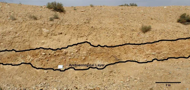
Site 330, roughly 9 meters above site 334 superior, represents the topmost layer of the Dauqara formation. As with site 330, the polygenetic and polycyclic of the site makes the interpretation of the layers a complicated matter. At the top, the E layer, the most recent layer is sterile of any archaeological material. Right below it the soil was illuviated with calcite and already underwent lithification or is currently undergoing lithification. There are no clearly defined boundaries between the rock and the harder soil drenched in calcite, but the topmost part is already fully rock while the lower part in contact with the Bt horizon is partially calcified. Consequentially, it was not possible with hand-tools to excavate the rock part of the section. The Bt horizon right below it is a transition area between the soil and the calcite intrusion. It is harder the closer to the rock layer and softer the closer to the Bk layer and it has accumulation of clay, being also fairly
27 heterogeneous with a usually brown or brownish color and varying size. Archaeological
28
materials start appearing in this layer, albeit sparsely. Below it, layer Bk has a considerable accumulation of clay and carbonate, acquiring a whitish color through its length. Lastly the B layer usually has sandy sediment and it is characterized by the
absence of clay, black soil lenses, most likely magnesium or other metals oxides. It has a brown color and a great presence of small pebbles, while the two layers on top of it usually have bigger pebbles, though it is not exclusive of them. The 330 section is concave while the sections of site 334 are straight with a slight slope on the top.
The soil horizons for the sites were done as macro groups to better understand
the site’s structure but they can be subdivided in smaller stratigraphic units. One of such observations was done by Parenti, (Caneva, et al., 2001) for site 330, which he divided in seven units: the first consisting of modern back dirt currently being farming terrace; second, hard crust formed by limestone, with scattered flakes; third, non-cemented, with rare cultural remains; fourth, river sedimentation, discontinuity side; fifth, sandy matrix, locally reddened on the bottom of paleo channel beds. Rich in paleontological and archaeological remains and considered paleo-soil; sixth, greyish layer gritty, sandy matrix, rich coble and flake industry; seventh, sub angular brownish sand grit in the matrix, being the oldest archeological phase in sequence.
For each site, the artifacts are usually found in one or two horizons. In the case of site 330, the artifacts are found mainly in the horizons B and Bk, while fossils were found only on horizon B. In site 334 inferior, the artifacts are heavily concentrated in between 20 to 50 meters of the section start, on the B (and BE) horizons that make up the “middle” of the visible section. These distribution patterns in horizons, both in 330 and 334, are by
no means exclusive and artifacts were found in other layers, albeit in a smaller quantity.
29
Methods
Data Gathering
The artifacts were collected during a fieldwork season in Jordan that occurred from 20/10/2014 to 07/11/2014. The fieldwork was organized and headed by Professors Fábio Parenti, President of the Italian Institute of Human Paleontology (Istituto Italiano Di Paleontologia Umana), Professor of Human Evolution and Physical Anthropology Walter Alves Neves, of the Biology Institute of the University of São Paulo, Professor of Archaeology and Geoarchaeology Astolfo Gomes de Mello Araújo, of the Museum of Archeology and Ethnology of the University of São Paulo, Professor of Geology Giancarlo Scardia from the University of the State of São Paulo and Professor of Human Evolution Maria Mercedes Martinez Okumura of the Federal University of Rio de Janeiro. This equip was complemented by the author of this study as a student, by
Assistant Professor Mark Hubbe of the Ohio State University, André Strauss, PhD student of the Max Planck Institute for Evolutionary Anthropology and Leipzig University, volunteers Ana Cristina Hochreiter, Gabriela Sartori Mingatos and Dr. Rodrigo Elias de Oliveira, all participated in the fieldwork for a period of time. Besides these researchers, a team of four local Chechens from the village of Sukhne helped to organize, communicate and helped during the excavations.
30
Before the collection of the material, a total station was set up and triangulated with three defined points. The section was divided by iron stakes every 5 meters for a profile to be set up, each stake point was recorded in the total station. In the case of 334
Inferior (Figure 11), 30 stakes were used (150 meters), for 334 Superior 48 stakes were used, totaling 240 meters and for the 330 section 13 states were used or 65 meters. Each of the stakes or points was photographed (Figure 12). Every point recorded with the total station was not only saved in the machine but written down in a spreadsheet and a separate notebook.
To collect the materials, each section was scraped using handpicks, mostly by scrapping the soil and breaking the conglomerate when it was needed. The section was systematically scraped from the beginning to the end, up to twenty centimeters inside and the artifacts found in situ were marked using the total station. After marked, the artifacts were collected in a plastic bag, given a tag with the point number they were attributed in the total station and stored.
Figure 13 - Detail of the section and of stake 5 of site 334 inferior