MARCIA DE MELO FARIA1and BRAZ A. SANCHEZ2 1DERNA/DGC/IBGE, 20031-170 Rio de Janeiro, RJ, Brazil
2LAGEMAR, Instituto de Geociências, Universidade Federal Fluminense, 24210-340 Niterói, RJ, Brazil
Manuscript received on September 15, 1999; accepted for publication on August 4, 2000; presented byDiogenes de Almeida Campos
ABSTRACT
Geochemical and clay mineralogical studies of bottom sediments collected along the Macacu and Caceribu rivers and Guanabara Bay were carried out in order to investigate the relationship between major source areas and recent sediments of the bay.
Clay mineralogy includes different groups with selective distribution conditioned by geomorphic features and depositional settings. Micaceous clay minerals are abundant near parent rock in the upper course, whereas kaolinite derived from varied sources is gradually concentrated towards the estuary. In the Guanabara Bay, kaolinite accumulates near river mouths, while micaceous clay minerals are converted into mixed layers in the estuary.
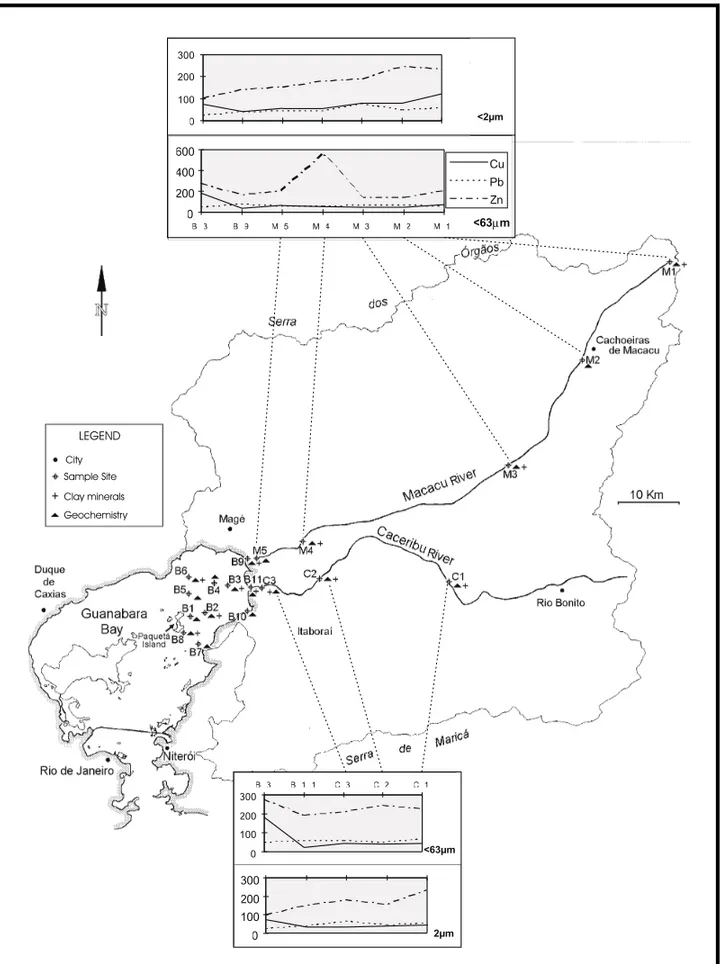
Analyses of heavy metal contents reveal higher levels of Zn and Cu in sediments of the bay than in river sedi-ments. Profiles along rivers indicate a downstream decrease of heavy metals, whereas in the bay geochemical trends display greater variations. In general river mouth sediments present the lowest concentrations. At the north and east of Paquetá Island anomalous areas with the highest heavy metal contents occur.
Cu tends to concentrate in< 2µmgrain-size fraction and indicates an association with micaceous clay minerals in the upper river course. However, Cu retention seems to be further controlled by other components of bottom sediments due to changes in physical and chemical conditions of the estuarine environment. Zn shows unstable behavior along the rivers and concentrates in the bay. Pb displays small variations from river to bay sediments, and accumulates mainly in the<63µmgrain-size fraction without any association with clay mineral.
Geoaccumulation indexes of Cu, Pb and Zn classify the study area as unpolluted in both studied rivers and in the NE sector of the bay, though the enrichment factors are higher in the bay. The study does not indicate those rivers as major sources of heavy metal pollution to the bay.
Key words:heavy metal, clay mineral, sediment, Guanabara Bay.
INTRODUCTION
Estuaries have been subject of considerable scien-tific interest over the last decades because of their environmental significance as material traps, and as
Correspondence to: Marcia de Melo Faria E-mail: mamf@ibge.gov.br
iments are very few when compared to marine sedi-ments (Malle 1990). Clay minerals are character-ized by large surface areas per mass unit, which accounts for their capacity of enrichment in heavy metals. Thus the clay-size fraction can be a reli-able indicator of environmental pollution (Förstner & Wittman 1981, Jenne 1977 apud Rybicka et al. 1995).
Guanabara Bay is an important Brazilian es-tuary located in the southeast coast of Brazil (Fig. 1), which has been receiving high amounts of urban effluents during last decades. Human activities (in-tensive urbanization and industrialization processes) promote the inflow and accumulation of polluted sediments mainly derived from the cities as Rio de Janeiro, Duque de Caxias, Nova Iguaçu, Niterói and São Gonçalo. The northeast sector of the bay was considered a “protected” area related with rural catchment areas, but Faria et al. (1995) reported a recent increase in heavy metal contents in the bottom sediments of the bay.
This study focuses on several geochemical pa-rameters and clay mineral distribution patterns in recent sediments of inner Guanabara Bay and its major rivers.
Study Site
The northeast sector of the bay is very shallow (3m in average). The tidal currents have the lowest ve-locities during the winter, 31 cm s-1 in the upper
layer (3m below sea surface) during the flood tide and 16 cm s-1in the ebb tide. In the summer,
ve-with 2,500mm (high mountains) and 1,500mm (low land) of rainfall predominates between December and April. Mean annual temperature is between 20-25◦C, but depends upon altitude and distance from the sea (Nimer 1989).
The study area can be subdivided into two main sectors, north and south, which include a wide va-riety of rock types of several ages (pre-Cambrian, Tertiary and Quaternary). The Macacu river is the main channel of the northern catchment area, drain-ing the high mountains of Serra dos Órgãos, whereas the Caceribu river is located in the southern catch-ment, draining the low mountains of Serra de Mar-icá. Considering forty-five streams flowing into the bay, the Macacu and Caceribu rivers have the largest catchment areas representing a total area of 2,700 km2. In contrast to other rivers that flow through the
urban regions, both drainage networks are mostly in-fluenced by rural activities, such as plantations (co-conut, banana, orange, mandioca) and pasture along their wide floodplains. In addition, the study area also comprises a typical estuarine ecosystem cov-ered with a mangrove forest which extends 10km landward.
METHODS
Clay mineral composition and heavy metals concen-trations of Cu, Pb and Zn were determined in bottom sediment samples taken along the rivers and within the estuary.
Fig. 1 – Location map of Guanabara Bay.
and eleven samples from the bay. Each sample was analyzed for two grain-size fractions:<63mmand < 2mm. The samples were digested with H2F2
-(1HCl-3HNO3) in a teflon bomb at 110◦C for 1 hour. After this procedure, Cu, Pb and Zn were analyzed in atomic absortion spectrophotometer. For quality control, USGS standards were prepared and ana-lyzed together with the samples using the same pro-cedures and reagents.
For mineralogical analyses, ten sediment sam-ples were separated for identification of clay miner-als. These were determined from the<2µm size-fraction previously freed of most interfering organic substances, salt, carbonate and iron (Jackson 1975). The samples were dispersed with ultrasonic waves and oriented on a glass slide. These clay slides were then successively run through an X-ray diffractome-ter Jeol - JDX 8030, under air-dried, ethylene gly-col solvated and heated at 500◦C in the 2θ range between 2-32 (Cu kαradiation). Identification of clay minerals and determination of their abundance
were based on DRX laboratory procedures accord-ing to Alves (1987). KCl saturation was performed to detect the presence of vermiculites in the bay sed-iments (only for station B1).
RESULTS AND DISCUSSION
Macacu River
chem-Fig. 2 – Ethylene glicol X-ray patterns in bottom sediments of Macacu and Caceribu rivers and Guanabara Bay. K = kaolinite, I = illite, V = vermiculite, G = gibbsite; mixed layers: I/V = illite/vermiculite, I/S = illite/smectite.
0 20 40 60 80
D istan ce (km )
0 200 400 600 800 1000 0 20 40 60 80 100
KAO LINITE ILLITE
ILL ITE /V ERM ICULITE
VE RMICU LITE (V ) V
B9 B 3 B 1 1
Floodpla in Ba y S a mp le s
Ma ngrove
M1 M3 M4 B2
Uppe r
ILLITE /SME CTITE
%
Alt
(m ) Low er
Fig. 3 – The relationship between clay mineral proportions and topographic profile of Macacu river.
ical weathering processes that together with high leaching originate this typical mineral assemblage. However, strong mechanical abrasion in the upper course makes physical weathering more efficient in formation of micaceous clay minerals (Faria 1997).
soils and rocks.
Downstream geochemical profiles (Fig. 4) show a decreasing trend of heavy metals, except Zn in 63µmgrain-size fraction in Macacu river sed-iments. The results also show a tendency of Cu and Zn concentration in the 2µmgrain-size fraction. Downstream of station M2 the river receives ur-ban effluents from smaller cities like Cachoeiras de Macacu, Guapi-Mirim and Magé, and also crosses a fishing club at station M4. Except for the very high concentration of Zn in station M4, apparently related to motorboat-generated pollution, heavy metal con-centrations tend to decrease downstream even under influence of these cities. Chester and Aston (1976) recognize that the overall chemical composition of river-transported sediments is controlled by a num-ber of factors. These include the geological nature of the catchment area; the drainage conditions; the intensity of local weathering processes and anthro-pogenic contamination, which can be significant in certain regions. The Macacu River does not exhibit an increasing trend despite urban input of heavy met-als because its drainage network is very efficient and the leaching is most intense in its catchment, thus dispersing the trace elements.
In the clay fraction, Cu and Zn concentrations decrease downstream more rapidly until station M3, apparently associated with micaceous clay minerals. Furthermore, organic matter and kaolinite contents are very abundant in the estuarine sediment. Pan-darinath and Narayana (1992) reported desorption mechanism in estuarine environment. This may be a possible reason for poor correlation between heavy metals and clay minerals in the Macacu estuary, since kaolinite does not correlate with the studied metals. On the other hand, humic acids can exert a high influence in the speciation of some metals within river waters, especially under low pH val-ues. Mantoura et al. (1978 apud Chester 1990) predicted that more than 90% of the Cu and Hg in river waters are complexed by humic material. Hu-mic complexed material tends to decrease with in-creasing salinity, but this decrease, which is rapid
for Mg, Ca, Zn, Cd, Mn and Co, is slow for Cu and Hg (Chester 1990). Both metals, mainly Cu, could be partly retained by organic matter, very abundant in the mangrove forest zone, which may explain the lowest heavy metal concentrations detected in this region.
Caceribu River
The highest sample station C1 is located in the mid-dle course of the river and its sediment is mostly composed of fine sand fraction (Faria 1997). Down-stream, silt makes up the dominant fraction and the organic matter content increases in the sediment. Clay mineralogy is very similar to that of Macacu River (Fig. 2), only differing by the absence of ver-miculite. Kaolinite is concentrated along the river toward Guanabara Bay, and illite/smectite mixed layers also appear in estuarine sediments.
bedload differing considerably from Caceribu river sediments (Faria 1997). Lithological units in the southern catchment comprise mostly rocks with acid composition, providing a natural background which superimposes the anthropogenic input of heavy met-als to the sediment. The main difference between the rivers is observed in Cu profiles, with lower values in Caceribu river, whereas Zn concentrations are very similar in 2µmfraction. Pb profiles have the same pattern, and concentrations are also very similar in both rivers.
Guanabara Bay
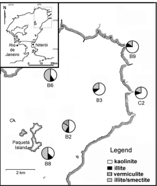
The bottom sediments of the inner sector of Gua-nabara Bay consist of mud, up to 80% of 63µm fraction (Haekel et al. 1985) with a high content of organic matter. The sediment is mostly terrige-nous, and dominant clay-size fraction includes mainly kaolinite in addition to illite (mica), ver-miculite, illite/vermiculite and illite/smectite mixed layers (Figs. 2 and 5). In the Bay, kaolinite tends to flocculate and concentrate near the river mouths, whereas the content in illite/smectite mixed layers increases seaward. Small amounts of illite are recorded in the sediments, and illite distribution in the bay is homogeneous.
In average, Guanabara Bay sediments have higher levels of Cu and Zn than the continental sed-iments (Table I). Therefore, the same comparison for Pb revealed that there is a minor variation in the Pb content among these depositional environ-ments. In general, heavy metal distribution patterns indicate river mouths as the regions with the low-est concentrations in both analyzed fractions (Figs. 6, 7 and 8). They also indicate anomalous sectors of high concentrations on the north and east sides of the Paquetá Island, probably related to anthro-pogenic input from the island and other polluted ar-eas around the bay. According to JICA (1994), the major pollution sources are the high effluent loads of the industrial complex from northwestern basins of the bay. Furthermore, the urban pollution de-rived from densely industrialized and residential
ar-eas, roads, railroads, airports, harbours. Artificial embankments in Rio de Janeiro and Niterói cities affect mainly the southern area of the bay, although it may reach the inner part of the bay due to tidal cur-rent action. The analysis of the heavy metal trends eliminate these major rivers as pollution sources to the bay as their heavy metal inputs are seemingly unrelated to the origin of these anomalies.
TABLE I
Heavy metals concentrations in average shale, Macacu River, Caceribu River and Guanabara Bay sediments.
Cu Pb Zn
Average shale* 45 20 95
Macacu river
sediments (<63mm) 58 67 255 Caceribu river
sediments (<63mm) 43 62 228 Guanabara Bay
sediments (<63mm) 119 69 290 Macacu river
sediments (<2mm) 79 57 204 Caceribu river
sediments (<2mm) 40 58 194 Guanabara Bay
sediments (<2mm) 78 40 199
*Turekian and Wedepohl (1961) apud Förstner and Wittman (1981). The concentrations are in ppm.
Geochemical and mineralogical data indicate that the lowest concentrations of heavy metals are located in kaolinite-rich sediments. However, the highest heavy metal concentrations do not corre-late with any clay mineral group, which may be attributed to changes in physical and chemical es-tuarine conditions. In addition, the role of organic matter in the formation and transformation of clay minerals, as well as in heavy metal adsorption have not been well investigated in this sector of the bay.
met-Fig. 5 – Clay mineral distribution in bottom sediments of northeastern sector of the bay (relative percent of 2µmgrain-size fraction).
als due to the active surface of Fe-oxides and clay minerals (Förstner & Wittman 1981). Metal sorp-tion reacsorp-tions of metals in different competing clay minerals studied by Rybicka et al. (1995) show the highest Pb enrichment for smectite and illite. Sev-eral environmental studies use clay minSev-eral associ-ations in sediments to trace the sediment transport in the estuarine environment (Irion & Zöllmer 1990, Pandarinath & Narayana 1992, Wijayananda & Cro-nan 1994). This association could not be observed for Pb in the studied area because Pb concentrations in<63µmfraction are higher than in<2µm frac-tion. This is probably related to the presence of feldspar, which like quartz is a very common
min-eral in bottom sediments. The association of both Cu and Zn with clay minerals is unclear in the bay, possibly because other components or combinations of them that may have played a more significant role in mobilization processes of these heavy metals.
Sediment Pollution
0.002mm 0.063mm
150
100 200 250 300
100 50 100
1000 0 1000 2000m 1000 0 1000 2000m
Paquetá Island
Paquetá Island
100
200 300 500400
600700
100 100
100
Macacu river Macacu
river
Caceribu river Caceribu
river
Fig. 6 – Cu distribution in bottom sediments of northeastern Guanabara Bay (contour lines are in ppm).
and Zn factors. The average was also calculated, and Figure 9 shows the input relation between the rivers and the bay. Cu average enrichment factor in the rivers remains within the natural background, char-acterized by lower average (1.0), whereas Zn and Pb averages reflect anthropogenic inputs in both studied environments (2.1 for Zn and 2.7 for Pb in the rivers, and 2.4 for Zn and 2.7 for Pb in the bay). Baptista Neto (1996) studied the sediments of the south of the bay, under high urban influence, and detected a wider range of enrichment factors for these metals (4.5-27 for Cu, 2-8 for Pb and 3-10 for Zn). The geoaccumulation index proposed by Müller (1979) for the pollution quantification was also calculated for sample stations, but in all of them the index re-mains in class 0, or unpolluted for Cu, Pb and Zn.
CONCLUSIONS
The rivers provide high contents of kaolinite to the bay, as well as minor proportions of illite (mica),
ver-miculite, illite/vermiculite and illite/smectite mixed layers. Besides climatic conditions, topography is an important factor that also controls the conversion and distribution of clay minerals along the rivers. In addition, gibbsite is relatively more abundant in Macacu sediments than Caceribu, possibly due to more efficient leaching attributed to the geomorphic features of Serra dos Órgãos. In the bay, a selective distribution of clay minerals occurs in function of fluvial discharges and hydrodynamic conditions of the bay, so that kaolinite tends to concentrate near the river mouths and illite/smectite mixed-layers con-centrates seaward.
0.063mm 0.002mm
1000 0 1000 2000m 1000 0 1000 2000m
Paquetá Island
Paquetá Island
50
60 70 80 70
80
Fig. 7 – Pb distribution in bottom sediments of northeastern Guanabara Bay (contour lines are in ppm).
in physico-chemical conditions of the estuary, should be checked in future studies.
Heavy metal profiles exhibit a decreasing downstream trend along the rivers with lowest con-centrations located in the river mouths. Concen-tration maps indicate highest concenConcen-trations to the north and east of Paquetá Island in Guanabara Bay. Heavy metal levels of river sediments reflect the geo-chemical properties of the source areas. The man-grove forest with its organic mud substrate seems to control the heavy metal supply to this inner sector of the bay, which still remains relatively unpolluted.
ACKNOWLEDGEMENTS
The authors are grateful to Dr. John McAlister and Dr. Bernard Smith of Queen’s University of Belfast for the lab facilities during geochemical analyses. The authors also thank to Dr. Sylvia dos Anjos and Dr. Daisy B.Alves of PETROBRÁS for DRX analy-sis and asanaly-sistance during the clay mineral
identifica-tions, to Dr. Rene Rodrigues for valuable comments to improve the content of this work and to Dr. José Henrique G. Melo for the English review. Thanks are also extended to CAPES and CNPq for financial support.
RESUMO
A correlação dos sedimentos recentes da Baía de Gua-nabara com as suas principais áreas-fontes foi realizada a partir de análises geoquímicas e de argilominerais em amostras de fundo coletadas ao longo dos rios Macacu e Caceribu e na baía.
con-Fig. 8 – Zn distribution in bottom sediments of northeastern Guanabara Bay (contour lines are in ppm).
Fig. 9 – Comparison of average enrichment factors of fluvial and Guanabara Bay sediments.
vertidos em interestratificados e depositados no fundo da baía.
As análises geoquímicas dos metais pesados no sedimento da baía detectaram níveis de Zn e Cu superiores aos níveis encontrados nos sedimentos fluviais. Os perfis de
C2 0,63 1,95 1,83
C3 0,74 2,23 1,64
B1 1,61 4,05 3,99
B2 3,18 3,25 2,65
B3 2,97 2,04 2,19
B4 1,90 2,41 2,34
B5 7,11 3,72 5,67
B6 2,06 1,93 1,95
B7 1,59 2,97 2,00
B8 1,72 2,90 2,03
B9 0,67 3,02 1,39
B10 0,44 1,32 1,08
B11 0,49 3,29 2,25
concentrações máximas situam-se ao Norte e a Leste da Ilha de Paquetá.
O Cu tende a se concentrar na fração argila podendo es-tar associado aos argilominerais micáceos do alto curso. Entretanto, no baixo curso, outros componentes do sedi-mento podem controlar a retenção do Cu em função das bruscas mudanças das condições físico-químicas no am-biente estuarino. O Zn apresenta um comportamento ins-tável ao longo dos rios e tende a se concentrar na Baía de Guanabara. Foram detectadas pequenas variações entre as concentrações de Pb dos sedimentos fluviais e da Baía de Guanabara. Este elemento tende a se concentrar mais na fração<63µm e não se associa a nenhum grupo de argilominerais.
Apesar dos fatores de enriquecimento dos metais pesados serem mais elevados na baía do que os fatores encontrados nos rios, os índices de acumulação de Cu, Pb e Zn ainda classificam a área de estudo como não poluída tanto os rios como o setor NE da baía. Este estudo não indica estes rios como as principais fontes poluidoras de metais
1(2): 157-175.
Amador ES.1992. Sedimentos de Fundo da Baía de Guanabara - Uma Síntese. In:III Congresso da As-sociação Brasileira de Estudos do Quaternário. Belo Horizonte, ABEQUA, 1992, p. 199-225.
Baptista Neto JA. 1996. Sedimentological Evidence for Human Impact on a Nearshore Sedimentary En-vironment: Jurujuba Sound, Rio de Janeiro State, Brazil. Ph.D dissertation, Belfast: Queen’s Univer-sity of Belfast, p. 351.
Chester R.1990. Marine Geochemistry. London: Un-win Hyman Ltd, p. 698.
Chester R. & Aston SR.1976. Chemical Oceanogra-phy. New York: Academic Press, p. 304-320.
Faria MM.1997. Caracterização mineralógica e geo-química dos sedimentos da porção NE da Baía de Guanabara e das suas áreas-fontes adjacentes. Tese de Mestrado, Niterói, Universidade Federal Flumi-nense, p. 147.
Faria MM, Sanchez BA, Smith B & McAlister JJ. 1995. Níveis de Poluição por Metais Pesados em Sedimentos Superficiais da Porção Nordeste da Baía de Guanabara. Cd rom, V Congresso Brasileiro de Geoquímica, Niterói, SBGq.
Förstner U & Wittman G.1981. Metal pollution in the aquatic environment. 2nd ed. Berlin: Springer Verlag, p. 484.
Haekel W, Schroeder F, Felsen V, Rebelo A de
Luca, Moreira I & Santelli R.1985. Cd, Pb, Cu, Cr e Hg in Waters and Sediments of The
Gua-nabara Bay Estuary. GKKS - Forschungszentrum
Irion G & Zöllmer V.1990. Pathways of fine-grained clastic sediments – Examples from Amazon, the Weser Estuary, and the North Sea. In:Sediments and environmental geochemistry (Selected Aspects and Case Histories). Berlin: Springer-Verlag, p. 351-366.
Jackson ML.1975. Soil chemical analysis, advanced course. 2.ed. Madison: published by author.
JICA (Japan International Cooperation Agency) 1994.The Study on Recuperation of The Guanabara Bay Ecosystem. Tokyo: Kokusay, Kogyo Co. Ltd., p. 73.
Malle KG.1990. The pollution of the River Rhine with heavy metals. In:Sediments and environmental geochemistry (selected aspects and case histories). Berlin: Springer Verlag, p. 279-290.
Müller G.1979. Schwermetalle in den Sedimenten des Rheins - Veränderungen seit, 1971.Umschau79(24):
778-783.
Nimer E.1989.Climatologia do Brasil. Rio de Janeiro: Instituto Brasileiro de Geografia e Estatística (IBGE).
PandarinathK & Narayana AC.1992. Clay Minerals and Trace Metal Association in the Gangoli Estuarine Sediments, West Coast of India. Estuarine, Coastal and Shelf Science35:363-370.
Rybicka EH, Calmano W & Breeger A.1995. Heavy metals sorption/desorption on competing clay miner-als; an experimental study. Applied Clay Science9:
369-381.
Wijayananda NP & Cronan DS.1994. The geochem-istry and mineralogy of marine sediments from the eastern Indian Ocean. Marine Geology117: