Maria Augusta Martins da Silva
and Amilsom Rangel Rodrigues
ABSTRACT.The objective of this study is the identification of the internal structure of the Holocene barrier of the Maric´a coastal plain (Rio de Janeiro, Brazil) for the understanding of the evolution of this coast. The regional geomorphology is characterized by the large Maric´a lagoon and by two sandy barriers which confines a series of small near-dry lagoons. Geophysical data obtained from ground-penetrating radar (GPR) images, with 400 and 200 MHz shielded antennae and borehole samples, both reaching down to about 10 meters in depth, provided information about the sedimentary architecture and geological and oceanographical processes responsible for the evolution of this area in the Holocene. The results show that the barrier internal structure is formed by a set of strata presenting different geometries, dip directions and organization, relative to the following depositional environments: dunes, washover fans, beach and tidal channels. It was possible to determine the importance of the sea level changes, longshore currents and overwash processes for the barrier development. Strong reflectors representing eolian strata dipping towards the continent point out to a phase of barrier retrogradation; afterwards, a succession of very well preserved beach paleoscarps, located south of the previous barrier, shows a phase of barrier progradation. Such evidences indicate that the barrier evolved according to the Holocene sea level fluctuations recognized for the Brazilian coast.
Keywords: ground-penetrating radar, barrier-lagoon system, Holocene, Maric´a coast.
RESUMO.O presente estudo objetivou identificar a estrutura interna da barreira holocˆenica buscando compreender a evoluc¸˜ao da plan´ıcie costeira de Maric´a (Rio de Janeiro). A geomorfologia regional ´e caracterizada pela Lagoa de Maric´a e duas barreiras arenosas, separadas por pequenas lagunas colmatadas. Dados geof´ısicos obtidos com um georadar, com antenas de 400 e 200 MHz, e amostras de sondagem geol´ogica, ambos at´e a profundidade m´edia de 10 metros, forneceram informac¸˜oes sobre a arquitetura sedimentar e os processos geol´ogicos e oceanogr´aficos respons´aveis pela evoluc¸˜ao desta ´area no Holoceno. Os resultados mostram que a estrutura interna da barreira ´e formada por um conjunto de estratos de diferentes geometrias, direc¸˜oes de mergulho e modos de organizac¸˜ao relacionados aos seguintes ambientes deposicionais: dunas, leques de arrombamento, praias e canais de mar´e. Essas caracter´ısticas permitiram o entendimento da dinˆamica costeira respons´avel pelo desenvolvimento da barreira, com destaque para as variac¸˜oes do n´ıvel do mar, correntes de deriva litorˆanea e mecanismos de sobrelavagem. Refletores marcantes representando estratos e´olicos inclinados para o continente indicam uma fase de retrogradac¸˜ao da barreira; a esse epis´odio se seguiu um per´ıodo marcado por sucessivas paleoescarpas de tempestade, localizadas mais ao sul, indicando uma fase de progradac¸˜ao. Essas evidˆencias mostram que a barreira evoluiu de acordo com as fases de transgress˜ao e regress˜ao marinha do Holoceno reconhecidas para o litoral brasileiro.
Palavras-chave: georadar, sistema barreira-laguna, Holoceno, litoral de Maric´a.
1Universidade Federal Fluminense, Oceans and Earth Dynamics, Department of Geology and Geophysics, Av. Gen. Milton Tavares de Souza s/n, Gragoat´a, Campus da Praia Vermelha, 24210-346 Niter´oi, RJ, Brazil. Phone: +55(21) 2629-5930; Fax: +55(21) 2629-5931 – E-mail: [email protected]
2Universidade do Estado do Rio de Janeiro, Department of Geography, R. Francisco Portela, 1470, Patronato, 24435-005 S˜ao Gonc¸alo, RJ, Brazil. Phone: +55(21) 3705-4631 – E-mail: [email protected]
3Universidade Federal Fluminense, Department of Geology and Geophysics, Niter´oi, RJ, Brazil – E-mail: [email protected]
i i
“main” — 2017/12/13 — 18:19 — page 462 — #2
i i
462
EVOLUTION OF THE MARIC´A HOLOCENE BARRIERINTRODUCTION
The evolution of Rio de Janeiro coastal plain (Fig. 1) was first studied by Lamego (1940, 1945), who, based on geomorpho-logical characteristics, proposed that the barrier-lagoon systems have been formed by the closing of earlier embayments by spit growth. Such hypothesis was later endorsed by studies on the Jacarepagu´a coastal plain, about 50 km from the present study area (Roncarati & Neves, 1976). The evolution of the coast be-tween Itacoatiara and Ponta Negra beaches (Fig. 1) was ad-dressed by Perrin (1984) who established that the barrier-lagoon systems were formed in the Holocene by sea level fluctuations. Muehe (1984) presented evidences for the retrogradation of the Holocene barrier, as for example, the presence of a submarine outcrop of beachrock parallel to the Itaipuac¸u beach. Ireland (1987) on the basis of diatom analysis collected from sound-ings from several lagoons from Itaipu to Guaratiba (Fig. 1), pro-posed that the inner barrier-lagoon system was formed in the Pleistocene and the outer barrier-lagoon system formed at about 7,200 years BP. Turcq et al. (1999) suggested that the inner barrier is 123,000 ± 5,700 years BP (based on Io/U dating of corals from Bahia done by Martin et al., 1982), and that such barrier was drowned by the Holocene transgression which then originated the most recent barrier-lagoon system, between 7,000 and 5,000 years BP. Work carried on the Itaipuac¸u coastal plain with GPR and boreholes identified a paleo barrier-lagoon; peat collected from the paleolagoon revealed the age of 6,040–5,900 years BP (Pereira, 2001; Pereira et al., 2003).
The results of a study integrating GPR, boreholes and AMS (Accelerator Mass Spectrometry) 14C data in this same area iden-tified a 20 m thick late Quaternary sequence and proposed a model for the evolution of this Maric´a area (Silva, 2011; Silva et al., 2014b). Three depositional sequences were recognized: the Pleistocene Sequence I, Pleistocene Sequence II (age between 48 and 45,000 cal years BP), and the Holocene Sequence (Fig. 2). The Holocene Sequence starts at about 8,560 cal years BP, the age of a beachrock that point out to the existence of a more southern barrier (about 100 m or so from today’s mean sea level mark). This barrier system began then a phase of retrogradation as sea level rose through the Holocene up to 5,000 years ago. The internal structure observed on the Holocene part of this coastal plain with the 200 MHz antenna, indicated this phase of ret-rogradation which, was then, followed by a phase o prograda-tion, giving rise to the present-day barrier (Silva, 2011; Silva et al., 2014b). Today, the barrier is in a new phase of retrogra-dation due to a rise in the sea level (Silva, 2011; Silva et al., 2014b; Lins-de-Barros, 2005; Silva, 2006; Silva et al., 2008b).
This article aims to improve the knowledge about the Holocene barrier. That will be achieved by the use of a new GPR antenna (400 MHz) to provide a better visualization of the Holocene bar-rier architecture. Also, the work will contribute to the understand-ing of the mechanisms that controlled the barrier evolution durunderstand-ing the time interval in question.
Study area
This work was developed at the Maric´a APA, an environmental protection area in the central part of the Maric´a coastal plain, in Rio de Janeiro State (Fig. 1). Although an environmental pro-tected area, and thus relatively well preserved as compared to other coastal areas of Rio de Janeiro, illegal sand mining (among other activities) has been destroying the local endemic flora and fauna, as well as the landscape, and there is an increasing concen-tration of population in nearby areas mainly due to the construc-tion of an oil refinery not far away. Despite this, the remaining landscape is suitable for GPR work.
The study area is characterized by the large Maric´a Lagoon and by two barriers that confine a small plain containing a chain-like series of isolated swamps and nearby dry lagoons (Fig. 1). The area is about 9 km long and is limited by the Maric´a Lagoon to the north and the Atlantic Ocean to the south (Figs. 1 and 3), to the west is the Itaipuac¸u Beach and to the east the Guaratiba Beach (Figs. 1 and 3). The inner barrier is Pleistocene (Ireland, 1987; Turcq et al., 1999; Silva, 2011; Silva et al., 2014b) as the outer barrier is Holocene (Perrin, 1984; Maia et al., 1984; Ireland, 1987; Turcq et al., 1999; Pereira et al., 2003; Silva, 2011; Silva et al., 2014b).
The Holocene barrier is in average 7 m high, reaching max-imum of 12 m em relation to mean sea level towards the central and east, and 5 m high towards the west of the area (Silva & Silva, 2010). The barrier is about 220 m wide exhibiting a levelled out relief, consequence of sand mining; there is a well defined beach storm scarp limiting the beach and the maximum reach of storm waves (Silva & Silva, 2010). Washover fans are present towards the east of the study area for about 2 km along the barrier (Fig. 3). On Itaipuac¸u barrier, the formation of overwash fans are com-monly observed during storms, depositing sands directly into the Canal da Costa (Fig. 1) (Silva et al., 2008b). Dunes occur mainly near the reverse face of the barrier (the barrier relief has been de-stroyed partially by the extraction of sand leaving a levelled sur-face) and are higher towards the east (Fig. 3) (Silva & Silva, 2010). The beach at Maric´a APA presents berms on the backshore and, sazonally, long channels parallel to the beach that turns perpen-dicular to it as the water escapes back to the sea; the foreshore is
Figure 1 – (A and B) Location of the study area in Rio de Janeiro, southeast Brazil. (C) Study area (Maric´a APA) in central coastal plain of
Maric´a. (D) Holocene barrier-lagoon system with topographic and GPR profiles and borehole locations. Geological Map (DRM-RJ, 1977).
Figure 2 – Lithologic units and depositional sequences that form the coastal sedimentary deposit of Maric´a (Silva et al., 2014b).
narrow and steep (Gralato, 2013). This is a wave-dominated coast with predominant S-SW storm waves during winter months, when waves can be 3 m high; SE waves prevail during fair weather
con-ditions (Muehe, 1979; Silva, 2006; Silva et al., 2008a; Pardal, 2009). The predominant longshore currents are to the west in re-sponse to the SE waves. However, the occasional incidence of
i i
“main” — 2017/12/13 — 18:19 — page 464 — #4
i i
464
EVOLUTION OF THE MARIC´A HOLOCENE BARRIERFigure 3 – (A) Aerial photo of the central coastal plain of Maric´a: Maric´a Lagoon to the North, two barriers (Pleistocene and
Holo-cene) separated by the lagoonal plain. Photo by Guichard, D. 2009. (B) Geomorphology of the Holocene barrier (storm scarp in detail).
waves from more than one direction (SE and SW) contributes to the formation of longshore currents to the east as well (Silva et al., 2008a). Maximum spring tidal fluctuation is 1.5 m (Navy Hydrograph Directory – DHN). The wind climate is strongly in-fluenced by the South Atlantic Subtropical anticyclone. The pre-vailing wind directions are from the east and northeast quadrants (Amarante et al., 2002). Occasionally, winds of stronger intensity come from the south and southwest associated with polar masses (CPTEC – INPE).
To attain the objectives of this work about the evolution of the Holocene barrier and its controlling mechanisms, GPR pro-files and boreholes data were obtained (Fig. 1).
MATERIALS AND METHODS
The morphology of the Holocene barrier has been character-ized by seven topographic profiles perpendicular to the coastline (from the beach to the landward face of the barrier) (Fig. 1). These profiles were obtained by conventional topographic equipment, always at times of calm sea and same tidal regime (quarter moon), and georeferenced with a Garmin GPS 12 XL equipment, the nav-igation system used was a WGS 84. A total of eight GPR pro-files were obtained, seven perpendiculars and one parallel to the coastline (Fig. 1). The parallel profile is discontinuous due to ob-stacles and topographic depressions (illegal extraction of sand). A Georadar GSSI (Geophysical Survey Systems Incorporated) SIR-3000 model has been used (Fig. 4). 400 and 200 MHz shielded antennae provided the best arrangement between
res-olution and penetration depth of 10 to 15 m, respectively. Data were processed in RADAN 6.6 (Radar Data Analysis) software, and included application of gains and filters, deconvolution, to-pographic correction and migration. Velocities have been deter-mined from CMP (Common Mid-Point) surveys in nearby areas, as of 0.10 mns-1(Pereira, 2001). This is the medium velocity
cal-culated from other CMP surveys in lagoonal muds and undersat-urated and satundersat-urated sands below the water table (Neal & Roberts, 2000 apud Neal, 2004).
The sandy sediments and the preservation of the environment are important factors for the high quality of the GPR data. The proximity to salty water is an impediment for high image reso-lution as a function of signal attenuation, which, then turns im-possible the observation of beach stratification. Trenches dug in these same sites in the 1970’s were used to help recognize the beach inner structure. The parallel profile was obtained adapting the equipment to a vehicle (Fig. 4B), which was then driven along the sand, away 30 m from the road, avoiding the interference of the clay in the GPR data. Clays, like the salty water, affect the quality of the GPR images (Neal et al., 2002; Neal, 2004; Bris-tow & Pucillo, 2006; Wang & Horwitz, 2007; Silva, 2011).
OpendTect software was used for interpretation, which was based on the main reflectors and reflection patterns. Basic prciples of seismic stratigraphy were applied to the radargram in-terpretation. Main patterns of reflections considered on this work are dip, shape, continuity, intensity and reflectors relationships (Neal, 2004).
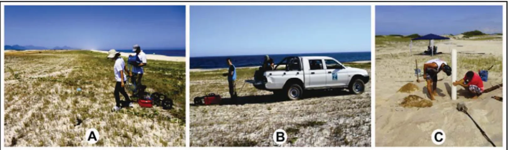
Figure 4 – Collecting GPR data: (A) 400 MHz antenna carried by hand; (B) 200 MHz antenna adapted to a vehicle; (C) Mechanical borehole.
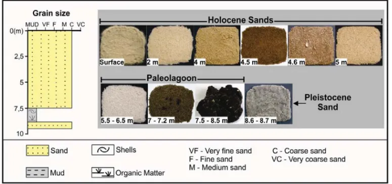
One borehole was obtained by mechanical borer in the area of Profile 2, and about 60 m from the storm scarp (Fig. 4C). The decision about the location of this well was based on the anal-ysis of GPR images in order to improve characterization of the observed layers, and assist in the interpretation of radargrams. The borehole reached the depth of 8.7 m and 20 samples were collected, at intervals of 0.5 m or when the sedimentary char-acteristics changed. These samples were described while in the field, and later grain size analyses were carried out and sediment classified according to Wentworth (1922 apud Pettijohn, 1975).
DATA PRESENTATION
Ground Penetrating Radar Profiles
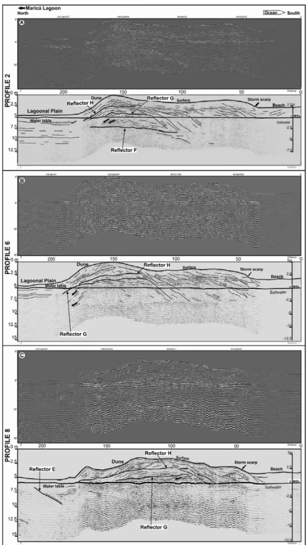
The radargrams showed high resolution, intense and continuous strata and reflexions patterns down to depths of about 10 m for the 400 MHz antenna and 15 m for the 200 MHz antenna. The perpendicular profiles with the 400 MHz antenna presented ex-cellent image between the landward face of the barrier and the beach storm scarp. On the beach, the image looses resolution due to signal attenuation as a function of the salty water (Neal et al., 2002; Daly et al., 2002; Neal, 2004; Silva, 2011, among others). These problems are sometimes impossible to correct dur-ing processdur-ing and they should not be considered for intertation (Neal, 2004). The parallel profile along the barrier pre-sented good resolution, in special the ones with the 400 MHz antenna. The perpendicular profiles exhibit geometries and re-flexion patterns which allowed the mapping of depositional uni-ties, and prominent reflectors which are unit limits (Fig. 5). The Holocene barrier internal structure presents stratification arrange-ments which indicate phases of retrogradation and prograda-tion. The parallel profiles (Figs. 6 and 7) show sets of reflectors that represent strata filling paleochannels; other reflectors seen in these parallel profiles represent major strata inclined both to
east and west, which suggests barrier lateral migration, as in a spit growth.
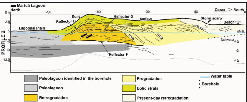
A continuous, horizontal and strong reflector appears in all profiles (Figs. 5 and 7), in depths varying from few centimeters (along the lagoonal plain) to about 5 m (underneath the area of dunes). It corresponds to the water table, as previously mapped by Silva (2011) and also confirmed by drilling during this work.
Along Profile 2, between the dunes area and the levelled sur-face of the barrier, at about 7 m deep, occurs a 75 m long reflector, horizontal to slightly inclined towards the sea, here named Reflec-tor F (Fig. 5A). This ReflecReflec-tor F is the upper limit of an area of low reflectance which indicates the presence of mud at this depth, confirmed by borehole (Fig. 8).
At depths varying from 7.5 to 3.5 m, below the dunes area, is possible to visualize (1) a set of layers dipping 5 to 45◦landwards (Fig. 5, black arrow); (2) towards the south, strata near horizontal to slightly inclined to the sea (Fig. 5). This depth interval is com-posed by sand (Fig. 8), probably deposited by wind, and it is lim-ited by Reflectors F (Profile 2) and G (Profiles 2, 6 and 8) (Fig. 5). Reflector G is inclined towards the sea and may represent a former barrier surface formed by erosion due to overwash processes. The geographic position of this deposit suggests a phase of retrogra-dation of the barrier, reaching its northernmost position during the Holocene. On top of this deposit, at depths between 3.5 and 2.0 m, a lenticular shaped layer of sand is present, limited by Re-flectors G and H (Fig. 5). This layer shows many internal reRe-flectors dipping 10 to 20◦landwards, on the landward faces of the barrier, and more horizontal reflectors towards the south (Fig. 5), a pat-tern which suggests overwash processes and formation of over-wash fan (Fig. 5). The sedimentary layer between the Reflectors F (Profile 2) G and H appears to have been truncated further south of the barrier (Fig. 5).
From 7 m deep to near the surface, under the levelled sur-face of the barrier to the present-day beach storm scarp (Fig. 5),
i i
“main” — 2017/12/13 — 18:19 — page 466 — #6
i i
466
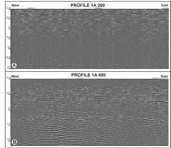
EVOLUTION OF THE MARIC´A HOLOCENE BARRIERFigure 6 – Profile 1A: Comparison between resolutions 200 and 400 MHz antennae.
we observe a set of reflectors dipping 22 to 40◦ seawards that truncates near horizontal beds (Fig. 5 – white arrow). Such ar-rangement is very similar to the one observed along modern beach storm scarps as it can be visualized in a trench dug in a nearby area in the 1970’s (Fig. 9). In the trench, surfaces dip-ping to the sea representing the removal of sand from the beach by storm waves leaving an inclined surface and a beach scarp clearly truncate near horizontal beds representing earlier berms; a new set of horizontal or near horizontal layers are seen on top of the truncation surface as the beach recovers its sand and gets wider. The implication, is that, the beach was located far-ther inland indicating that the barrier progressively prograded to a new position.
Between Reflector H and the surface, a 2.5 m thick sand de-posit shows plane-parallel strata inclined 30-35◦ landwards as well as cross beds typical of dunes (Fig. 5). There is a distinct reflector inclined to the continent, in the middle of this sand deposit, that may represent the migration surface of the dune (Profiles 6 and 8 – Fig. 5).
From the present-day storm scarp, which represents the beach limit, on towards the beach, it is difficult to visualize any reflectors due to the influence of the salty water. Few are recogniz-able, though, and they are plane-parallel layers dipping landwards
which may represent berms (Fig. 5). The internal beach structure seen in the trench in nearby Itaipuac¸u (Fig. 9) help the identifi-cation of the characteristic stratifiidentifi-cation of this environment: near horizontal layers truncated by surfaces inclined 10 to 16◦to the sea. The inclined surfaces represent removal of sand by storm waves which leaves a steep and shortened beach, that latter recov-ers its width by the accreting sands forming new berms, typical of beach dynamics.
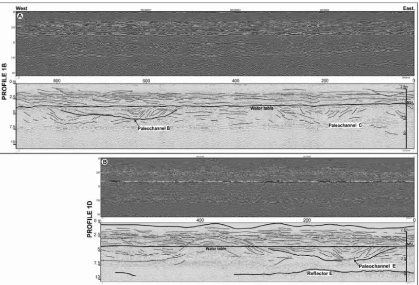
The parallel Profile 1 (Figs. 7A and B) was obtained along the length of the Holocene barrier (Fig. 1) with the 200 and 400 MHz antennae. The profile covered, discontinuously, the area from west to east due to obstacles for the dislocation of the equipment. The 400 MHz antenna better displayed the barrier internal structure (Fig. 6). In this work, only two of the sections collected with the 400 MHz antenna are presented (Fig. 7).
The Pleistocene/Holocene boundary is observed on Profile 1 (Reflector E – Fig. 7), as an erosive surface as previously defined by Silva (2011). This erosive surface was also observed on Pro-file 8 (Fig. 5C). Reflector E appears, at about 8 m of depth, as a discrete (and more proeminent to the west), near horizontal and discontinuous, extending for about 340 m (Profile 1D – Fig. 7B). Above Reflector E, between 8 and 3 m of depth, a sandy deposit exhibits a variety of stratification patterns (Fig. 7):
i i
“main” — 2017/12/13 — 18:19 — page 468 — #8
i i
468
EVOLUTION OF THE MARIC´A HOLOCENE BARRIERFigure 7 – Section of the GPR Profile 1 acquired parallel to the shoreline with 400 MHz antenna. (A) Profile 1B and (B) Profile 1D.
(1) layers dipping 6 to 45◦to the east; (2) plane-parallel near horizontal strata; (3) strata dipping 11 to 45◦to the west; and (4) a cut-and-fill pattern indicative of paleochannels. Three paleochannels were identified at depths between 6 and 3 m along the barrier (Profile 1 – Fig. 7), varying from 240 to 260 m of width and about 3 m of depth. These channels’ sedimentary in-fillings are characterized by layers dipping both to east and west, and the concave shape of some surfaces is indicative of the pro-gressive shallowing of these paleochannels (Fig. 7).
From the depth of 3 m to the barrier surface, near horizon-tal layers predominate, showing concave up and convex geome-tries, while some others are slightly inclined both to east and west (Profile 1 – Fig. 7). In the uppermost 1 m section of this profile no reflectors are observed (Fig. 7).
Borehole
The borehole (Fig. 8, see Fig. 1 for location) presented only two lithologies: a basal mud layer, between the depth of 8.5 and 7.5 m;
and a 7 m thick layer of sand on top (Fig. 8). Grain size analyses of 20 samples indicated that coarse sand predominates (Fig. 8).
The basal mud layer is black with an intense smell of or-ganic matter decomposition, presents whole shells as well as fragments, and plane-parallel layering (Fig. 5). This mud layer changes upwards (around 7.2 to 7 m depth) to a thin layer of a coarse dark brown sand, possible muddy (Fig. 8). These are characteristics of sediments deposited in a lagoonal environment. In nearby Itaipuac¸u beach (Fig. 1), at the same geological setting and depth, a paleolagoon was identified and sediments were C14
dated providing the age of 6,040–5,900 years BP (Pereira, 2001; Pereira et al., 2003).
The upper sand layer (Fig. 8), from 7 m deep to the surface, is coarse and quartz rich with feldspars and few shells. Between 5.5 and 6.5 m depths the sand is light gray or white (Fig. 8). This type of sand is characteristic of the Pleistocene barrier (Silva, 2011; Silva et al., 2014b). The rest of the sand section, from 5 m up to the surface, is composed by a coarse light yellow or brown-ish sand (Fig. 8). The water table is reached at an average depth of 4 m.
Figure 8 – Main characteristics of the sediments collected with the borehole.
Figure 9 – Trench in nearby Itaipuac¸u Beach (see Fig. 1 for location) showing the beach internal structure (report to CNPq by Silva, 1972).
DISCUSSION
The main reflectors and reflexions patterns mapped, and the samples collected in the boreholes allow the identification of two lithological unities: (1) a basal mud layer which is here in-terpreted as been deposited in a paleolagoon; (2) an overly-ing 7 m thick sand layer which represents the Holocene barrier (Fig. 10). The depositional architecture of the barrier-lagoon
sys-tem was revealed through a set of stratification presenting dif-ferent geometries, dip angles and directions and organization, pointing out to the presence of earlier dunes, overwash fans, beach and beach storm scarps (Fig. 10). Major reflectors orga-nized with dips either towards land and to the sea indicate phases of retrogradation and progradation of the barrier through the Holocene (Fig. 10).
i i
“main” — 2017/12/13 — 18:19 — page 470 — #10
i i
470
EVOLUTION OF THE MARIC´A HOLOCENE BARRIERFigure 10 – Depositional architecture of the Holocene barrier-lagoon system (based mainly on Profile 2).
Surface E (Figs. 5C and 7), the boundary between the Pleis-tocene and Holocene, is present throughout the area, from the lagoonal plain to the Holocene barrier, as proposed by Silva (2011) and Silva et al. (2014b) and confirmed by the present work. Surface E continuation across the Holocene barrier is diffi-cult to observe due to the nearness to the salty water. This surface E was formed by an erosive process during land exposure in a low sea level phase (Silva, 2011; Silva et al., 2014b).
The lower section of the sequence is here represented by a mud layer that changes upwards to a sandy mud layer; the basal mud shows plane-parallel bedding, mostly under the lagoonal plain (Figs. 5 and 10). This sedimentary unit is similar to the one found in Itaipuac¸u and, there, it was dated as 6,000 years BP (Pereira, 2001; Pereira et al., 2003). The extension of this mud layer under the Holocene barrier is an evidence for a ret-rograding phase of an earlier barrier located farther south (Silva, 2011; Silva et al., 2014). Such barrier can be identified as the 8,560 years cal BP beachrock outcrop present along the Itaipuac¸u nearshore (Silva, 2011; Silva et al., 2014a; Silva et al., 2014b). The beachrock and the lagoonal mud layer form the base of the Holocene Coastal Sequence as defined by Silva (2011) and Silva et al. (2014b).
At about 150 m from mean tide level and from 7.5 to 3 m of depth, sands exhibiting stratification dipping 20-45◦ landwards mark the innermost reach of the barrier during the Holocene. This deposit, here interpreted as dunes, is over the lagoonal muds (arrows Fig. 10). This is best observed along Profile 2 and disappears towards the east where the Holocene sands di-rectly overlie on the Pleistocene sand. The position of the
bar-rier here is probably related to the maximum sea transgres-sion during the Holocene at 5,100 years BP (Ireland, 1987; Turcq et al., 1999; Pereira et al., 2003; Silva, 2011; Silva et al., 2014a). This retrograding phase of the barrier has been al-ready indicated by Silva (2011) and Silva et al. (2014b) for this Maric´a coastal area, and also in Itaipuac¸u coast (Pereira, 2001; Pereira et al., 2009).
The barrier was then partially eroded by storm waves which gave rise to an erosive surface (represented by Reflector G – Fig. 10). To the south, this erosive surface seems truncated by another surface (Figs. 5 and 10) and the relationship between them is similar to present-day beach storm scarps (Fig. 9). Over the erosive surface G, and limited by Reflector H, from 2.7 to 1.7 m depth, occurs a sand deposit presenting layers which are plane-parallel horizontal as well as inclined 10-20◦ landwards, similar to the architecture of washover fans (Figs. 5 and 10) (McCub-bin, 1982). Washover fans are seen today along this barrier on the study area (Fig. 3) and along the Itaipuac¸u barrier (Silva et al., 2008b). In subsurface, examples were presented with GPR images also in Itaipuac¸u (Pereira, 2009). Storm waves and washover fan formation compose an important process forcing the retrogradation of a barrier in different parts of the world (Morton, 2002; Morton & Sallenger, 2003; Dillenburg et al., 2004; Donnelly et al., 2004; Caldas et al., 2006; Switzer et al., 2006; Wang & Horwitz, 2007; Houser et al., 2008; Matias et al., 2008; Sedrati et al., 2011; Phantuwongraj et al., 2013).
During most of the last 5,100 years BP, the barrier prograded (Fig. 10) as sea level lowered along the Brazilian coast (Martin et al., 1987 apud Martin et al., 2003; Angulo & Lessa, 1997). The
progradation, has been also observed in different barrier systems of the Brazilian coast and considered the result of sea level fluc-tuations during the Holocene (Tomazelli et al., 2000; Tomazelli & Dillenburg, 2007; Guedes et al., 2011).
The three paleochannels mapped along the barrier at depths varying from 6 to 3 m (Fig. 7) seem to be associated with the progradation phase of the barrier. The sediments in these chan-nels show strata dipping either to west and east (slightly predomi-nating). In Itaipuac¸u, similar paleochannels were also found in the Holocene barrier though deeper (depth of 10 to 15 m) (Pereira, 2001; Pereira et al., 2003).
On the area of dunes, from the surface to depths of 1.5 to 3 m, a coarse quartz sand deposit with planar cross-strata show-ing dips of 30-45◦ landwards is found (Figs. 5 and 10). Such coarse sands dunes is not usual, but in the Maric´a coast coarse sand dunes have been observed today to under storm wind con-ditions (Silva et al., 2014c). It is here proposed, though pre-liminary, that these earlier dunes are associated to the phase of barrier progradation.
On the beach, despite the low quality of the radargrams, plane-horizontal stratification such as observed on berms (Fig. 9) was identified (Fig. 10).
Large-scale stratification found in depths varying from 7 to 3 m on Profile 1 (Fig. 7) shows dips either to west and east (in this case, slight predominant), and could be an indication of longshore currents playing a role on the barrier formation as a spit. The data are not conclusive and needs further research, but it may be an evidence that, at times, the evolution of the barrier was the result of sea level fluctuation as well as the drifting of sands by longshore current, a combination of causes, hypothesis proposed by Schwartz (1971) for the evolution of barrier systems. Holocene sea level curves for the Brazilian coast (Martin et al., 1987 apud Martin et al., 2003; Angulo & Lessa, 1997) show that sea level overtopped today’s level at about 7,000 years ago and reached a maximum of 3 to 5 m above present-day level at about 5,100 years ago. After that, sea level gradually fell to its present
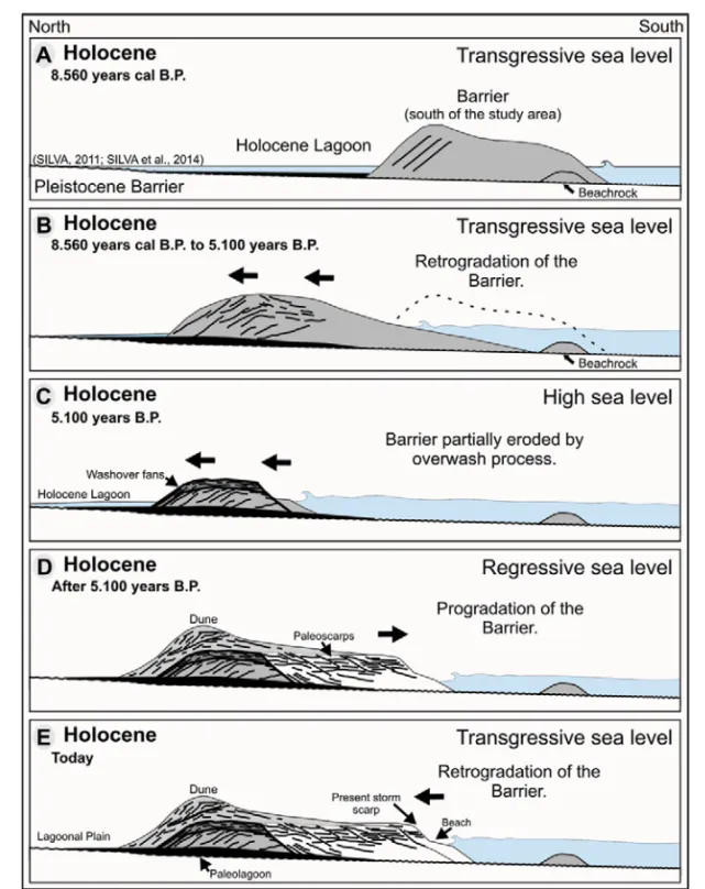
(Fig. 11): (1) a barrier located towards the south which gave rise to a beachrock formation at about 8,560 years cal BP (Fig. 11A), as proposed by Silva et al. (2014a; 2014b). (2) A lagoon was as-sociated to this barrier since a mud layer is found under the barrier as the sea progressively rose (the Holocene transgression) and promoted retrogradation of the barrier (Fig. 11B). (3) The trans-gression reached a maximum at about 5,100 years BP (Figs. 11B and C). During this time interval, the barrier was partially eroded by overwash process which left an erosive surface and washover fans as records of this phase (Fig. 11C); (4) a sea level fall and progradation of the barrier, seen as a succession of beach storm scarps (Fig. 11D); and (5) for the last 30 years, sea level has been rising leading to the retrogradation of the barrier (Lins-de-Barros, 2005; Silva et al., 2008b).
CONCLUSIONS
With this work it was possible to improve the understanding of the formation and the evolution of the Maric´a Holocene barrier (Rio de Janeiro). GPR data combined to sample collected from boreholes allowed the visualization of the barrier inner structure and architecture down to about 10 m deep and its sedimentary characteristics.
The results indicated the presence of a basal mud layer, about 1 m thick, deposited in a lagoon; on the top of it, a 7 m thick coarse sand layer represents the Holocene barrier. The barrier exhibits distinct reflexion patterns which permits to individualize phases of barrier migration during the Holocene: (1) At approxi-mately 8,000 years BP, beachrock in nearby areas (Itaipuac¸u and the Jacon´e beaches) are evidences for a barrier located towards the south (today’s nearshore zone) and the onset of sedimenta-tion in the area in the Holocene (Silva, 2011; Silva et al., 2014a; Silva et al., 2014b); (2) on the reverse face of this barrier, a la-goon was present; sediments collected from a similar lala-goonal mud layer in Itaipuac¸u indicated the age of about 6,000 years BP (Pereira, 2001; Pereira et al., 2003). The stratigraphic position
i i
“main” — 2017/12/13 — 18:19 — page 472 — #12
i i
472
EVOLUTION OF THE MARIC´A HOLOCENE BARRIERFigure 11 – Proposed model for the evolution of the barrier-lagoon system of Maric´a (RJ).
of the mud layer points out a transgressive sea (the Holocene Transgression). The surface of this mud layer is marked by Re-flector F; (3) the barrier begun to retrograde to a more northern position in response to a gradual sea level rise, which reached its maximum at about 5,100 years BP. The barrier sands overtopped the lagoonal mud or were deposited over the erosive surface F; (4) intensive storm waves partially eroded the barrier leaving a surface representing such events (Reflector G) and formed washover fan deposits (limited by Reflector H); (5) the subsequent falling of the sea level, during the last 5,100 years, caused the
progradation of the barrier. This phase of progradation is charac-terized and can be recognized by a succession of beach storm scarps; also, in this prograding barrier system, paleochannels seemed to be present. The sediments filling these channels show layers dipping either to west and east (this last direction slightly predominates); (6) A set of eolian cross-strata, forming a 2 m thick deposit, located at the barrier crest, is probably related to this phase of progradation; and (7) For the last 30 years, the Maric´a barrier system shows a retrograding behavior (Lins-de-Barros, 2005; Silva et al., 2008b).
Special thanks to CAPES for the master degree scholarship. Dur-ing field work, S´ergio Cadena help the authors with GPR acquisi-tion; also Drs. Alberto Figueiredo Jr. and Guilherme Fernandes, both from UFF, for lending the vehicle and equipment that made this work possible. To Ronaldo and his team for their professional attitude during the drilling phase of the research. Thank all the students and colleagues who cooperated in many different ways to this work.
REFERENCES
AMARANTE OAC, SILVA FJL & RIOS FILHO LG. 2002. Estado do Rio de Janeiro: Atlas E´olico. Secretaria de Estado de Energia, da Ind´ustria Naval e do Petr´oleo, Camargo Schubert, 83 pp.
ANGULO RJ & LESSA GC. 1997. The Brazilian sea-level curves: a crit-ical review with emphasis on the curves from Paranagu´a and Canan´eia regions. Marine Geology, 140: 141–166.
BRISTOW CS & PUCILLO K. 2006. Quantifying rates of coastal progra-dation from sediment volume using GPR and OSL: the Holocene fill of Guichen Bay, south-east South Australia. Sedimentology, 53: 769–788. CALDAS LHO, STATTEGGER K & VITAL H. 2006. Holocene sea-level history: Evidence from coastal sediments of the northern Rio Grande do Norte coast, NE Brazil. Marine Geology, 228: 39–53.
CPTEC-INPE. Centro de Previs˜ao de Tempo e Estudos Clim´aticos – Instituto Nacional de Pesquisas Espaciais. Available on:
<http://ondas.cptec.inpe.br/>. Access on: October 30, 2012. DALY J, McGEARY S & KEANTZ DE. 2002. Ground-penetrating radar in-vestigation of a late Holocene spit complex: Cape Henlopen, Delaware. Journal of Coastal Research, 18(2): 274–286.
DILLENBURG SR, TOMAZELLI LJ & BARBOZA EG. 2004. Barrier evo-lution and placer formation at Bujuru southern Brazil. Marine Geology, 203: 43–56.
DONNELLY JP, BUTLER J, ROLL S, WENGREN M & WEBB III T. 2004. A Backbarrier Overwash Record of Intense Storms from Brigantine, New Jersey. Marine Geology, 210: 107–121.
Geology, 285: 1–16.
HOUSER C, HAPKE C & HAMILTON S. 2008. Controls on coastal dune morphology, shoreline erosion and barrier island response to extreme storms. Geomorphology, 100: 223–240.
IRELAND S. 1987. The Holocene sedimentary history of the coastal la-goons of Rio de Janeiro State, Brazil. In: TOOLEY MJ & SHENNAN I (Eds.). Sea-Level Changes. Oxford. Blackwell Ltd. 25–66.
LAMEGO AR. 1940. Restingas na Costa do Brasil. Divis˜ao de Geologia e Mineralogia. DNPM, Brazil, Boletim 96: 63 pp.
LAMEGO AR. 1945. Ciclo Evolutivo das Lagunas Fluminenses. Divis˜ao de Geologia e Mineralogia. DNPM, Brazil, Boletim 118: 47 pp. LINS-DE-BARROS FM. 2005. Risco, Vulnerabilidade F´ısica `a Eros˜ao Costeira e Impactos S´ocio-econˆomicos na Orla Urbanizada do Munic´ı-pio de Maric´a, Rio de Janeiro. Revista Brasileira de Geomorfologia, 6: 83–90.
MAIA MCAC, MARTIN L & FLEXOR JM. 1984. Evoluc¸˜ao Holocˆenica da plan´ıcie costeira de Jacarepagu´a (RJ). In: Congresso Brasileiro de Geo-logia, 33., Rio de Janeiro, Brazil, 105–118.
MARTIN L, DOMINGUEZ JML & BITTENCOURT ACSP. 2003. Fluctuating Holocene Sea Levels in Eastern and Southeastern Brazil: Evidence from Multiple Fossil and Geometric Indicators. Journal of Coastal Research, West Palm Beach, Florida, 19(1): 101–124.
MARTIN L, SUGUIO K & FLEXOR JM. 1987. Flutuac¸˜oes do n´ıvel re-lativo do mar no Quatern´ario e seu papel na sedimentac¸˜ao costeira: exemplos brasileiros. In: Simp´osio sobre Ecossistemas da Costa Sul e Sudeste Brasileira, 1., Cananeia, S˜ao Paulo, Brazil, 40–61.
MATIAS A, FERREIRA O, VILA-CONCEJO A, GARCIA T & DIAS JA. 2008. Classification of washover dynamics in barrier islands. Geomor-phology, 97: 655–674.
McCUBBIN DG. 1982. Barrier-island and strand plain facies. In: SCHOLLE PA & SPEARING D (Eds.). Sandstone Depositional Environ-ments. Tulsa, Oklahoma, The American Association of Petroleum Geo-logists, 247–279.
MORTON RA. 2002. Factors controlling storm impacts on coastal bar-riers and beaches – A preliminar basis for near real-time forecasting. Journal of Coastal Research, 18(3): 486–501.
i i
“main” — 2017/12/13 — 18:19 — page 474 — #14
i i
474
EVOLUTION OF THE MARIC´A HOLOCENE BARRIERMORTON RA & SALLENGER AHJR. 2003. Morphological impacts of Extreme Storms on Sandy Beaches and Barriers. Journal of Coastal Research. West Palm Beach, Florida, 19(3): 560–573.
MUEHE DCEH. 1979. Sedimentology and Topography of a High Energy Coastal Environment between Rio de Janeiro and Cabo Frio – Brazil. Anais da Academia Brasileira de Ciˆencias, 51(3): 473–481.
MUEHE DCEH. 1984. Evidˆencias de recuo dos cord˜oes litorˆaneos em direc¸˜ao ao continente no litoral do Rio de Janeiro. In: LACERDA LD, ARA ´UJO DSD, CERQUEIRA R & TURCQ B (Eds.). Restingas: origem, estruturas e processos. CEUFF, Niter´oi, Rio de Janeiro, Brazil, 75–80. NEAL A. 2004. Ground-penetrating radar and its use in sedimentology: principles, problems and progress. Earth Science Reviews, 66: 261–330. NEAL A & ROBERTS CL. 2000. Applications of ground-penetrating radar (GPR) to sedimentological, geomorphological and geoarchaeological studies in coastal environments. In: PYE K & ALLEN JRL (Eds.). Coastal and Estuarine Environments: Sedimentology, Geomorphology and Geo-archaeology. Geol. Soc. London Spec. Publ., 175: 139–171.
NEAL A, PONTEE NI, PYE K & RICHARDS J. 2002. Internal struc-ture of mixed-sand-and-gravel beach deposits revelead using ground-penetrating radar. Sedimentology, 49: 789–804.
PARDAL MTC. 2009. Mudanc¸as morfol´ogicas e suas implicac¸˜oes para a estabilidade da praia na Regi˜ao do Recanto de Itaipuac¸u, Maric´a, RJ. Master Dissertation, Programa de P´os-Graduac¸˜ao em Geologia e Geof´ısica Marinha, Universidade Federal Fluminense, Rio de Janeiro, Brazil, 148 pp.
PEREIRA AJ. 2001. Investigac¸˜ao da Estratigrafia da Regi˜ao Costeira de Maric´a – Praia de Itaipuac¸´u (RJ) – Atrav´es do Ground Penetrating Radar (GPR). Master Dissertation, Programa de P´os-Graduac¸˜ao em Geologia e Geof´ısica Marinha, Universidade Federal Fluminense, Rio de Janeiro, Brazil, 93 pp.
PEREIRA AJ. 2009. Caracterizac¸˜ao estratigr´afica da plan´ıcie costeira de Itaipuac¸´u (Maric´a) – Rio de Janeiro, durante o Quatern´ario. Doctoral Thesis, Programa de P´os-Graduac¸˜ao em Geologia e Geof´ısica Marinha, Universidade Federal Fluminense, Rio de Janeiro, Brazil, 388 pp. PEREIRA AJ, GAMBOA LAP, SILVA MAM, RODRIGUES AR & COSTA A. 2003. A Utilizac¸˜ao do Ground Penetrating Radar (GPR) em Estudos de Estratigrafia na Praia de Itaipuac¸´u – Maric´a (RJ). Brazilian Journal of Geophysics. EDUFF, Niter´oi, Rio de Janeiro, Brazil, 21(2): 163–172. PERRIN P. 1984. Evoluc¸˜ao da Costa Fluminense entre as Pontas de Ita-coatiara e Negra, preenchimentos e restingas. In: LACERDA LD, ARA ´UJO DSD, CERQUEIRA R & TURCQ B (Eds.). Restingas, origens, processos. CEUFF, Niter´oi, Rio de Janeiro, Brazil, 65–74.
PETTIJOHN FJ. 1975. Sedimentary Rocks. 3rd ed., Harper and Row Publishers, New York. 628 pp.
PHANTUWONGRAJ S, CHOOWONG M, NANAYAMA F, HISADA K, CHARUSIRI P, CHUTAKOSITKANON V, PAILOPLEE S & CHABANG-BON A. 2013. Coastal geomorphic conditions and styles of storm surge washover deposits from Southern Thailand. Geomorphology, 192: 43–58.
RONCARATI H & NEVES LE. 1976. Projeto Jacarepagu´a: Estudo geo-l´ogico preliminar dos sedimentos recentes superficiais da Baixada de Jacarepagu´a, Munic´ıpio do Rio de Janeiro – RJ, Brazil. PETROBRAS, CENPES. DEXPRO. 89 pp.
SCHWARTZ ML. 1971. The multiple causality of barrier island. Journal of Geology, 79: 91–94.
SEDRATI M, CIAVOLA P & ARMAROLI C. 2011. Morphodynamic evo-lution of a microtidal barrier, the role of overwash: Bevano, Northern Adriatic Sea. Journal of Coastal Research, SI 64 (Proceedings of the 11th International Coastal Symposium), 696–700.
SILVA MAM. 1972. Relat´orio Final de Iniciac¸˜ao Cient´ıfica, Conselho Nacional de Desenvolvimento Cient´ıfico e Tecnol´ogico (CNPq). 20 pp. SILVA ALC. 2006. Comportamento Morfol´ogico e Sedimentol´ogico do Litoral de Itaipuac¸´u (Maric´a) e Piratininga (Niter´oi), RJ, nas ´ultimas trˆes d´ecadas. Master Dissertation, Programa de P´os-Graduac¸˜ao em Geologia e Geof´ısica Marinha, Universidade Federal Fluminense. Rio de Janeiro, Brazil, 153 pp.
SILVA ALC. 2011. Arquitetura sedimentar e evoluc¸˜ao geol´ogica da plan´ıcie costeira central de Maric´a (RJ) ao longo do Quatern´ario. Doctoral Thesis, Programa de P´os-Graduac¸˜ao em Geologia e Geof´ısica Marinha, Universidade Federal Fluminense, Rio de Janeiro, Brazil. 185 pp.
SILVA ALC & SILVA MAM. 2010. Caracterizac¸˜ao geomorfol´ogica e sedimentar da plan´ıcie costeira central de Maric´a (Rio de Janeiro). VII Simp´osio Nacional de Geomorfologia. Recife, Brazil, 1–15.
SILVA ALC, SILVA MAM & SANTOS CL. 2008a. Comportamento Mor-fol´ogico e Sedimentar da Praia de Itaipuac¸´u (Maric´a, RJ) nas ´ultimas Trˆes D´ecadas. Revista Brasileira de Geociˆencias, 38(1): 87–97. SILVA ALC, SILVA MAM, SANTOS CL, RIBEIRO GB, SANTOS RA & VASCONCELOS SC. 2008b. Retrogradac¸˜ao da Barreira Arenosa e Formac¸˜ao de Leques de Arrombamento na Praia de Itaipuac¸´u (Oeste de Maric´a, RJ). Revista Brasileira de Geomorfologia, 9(2): 75–82. SILVA ALC, SILVA MAM, SOUZA RS & PINTO MLV. 2014a. The role of beachrocks on the evolution of the Holocene barrier systems in Rio de Janeiro, southeastern Brazil. In: GREEN AN & COOPER JAG (Eds.). Pro-ceedings 13th International Coastal Symposium (Durban, South Africa), Journal of Coastal Research, SI 70: 170–175.
SILVA ALC, SILVA MAM, GAMBOA LAP & RODRIGUES AR. 2014b. Sedimentary architecture and depositional evolution of the Quaternary
TOMAZELLI LJ & DILLENBURG SR. 2007. Sedimentary facies and stratigraphy of a last interglacial coastal barrier in south Brazil. Marine
WANG P & HORWITZ MH. 2007. Erosional and Depositional Charac-teristics of Regional Overwash Deposits caused by Multiple Hurricanes. Sedimentology, 54: 545–564.
Recebido em 5 setembro, 2014 / Aceito em 23 fevereiro, 2016 Received on September 5, 2014 / Accepted on February 23, 2016
NOTES ABOUT THE AUTHORS
Carolina Pereira Silvestre. Geographer from the Universidade do Estado do Rio de Janeiro (UERJ) in 2010. Master in Marine Geology and Geophysics from the
Universidade Federal Fluminense (UFF). Currently, is a doctoral student at the Geology and Geophysics Department (Oceans and Earth Dynamics) at UFF.
Andr´e Luiz Carvalho da Silva. Geographer from the UERJ in 2003. Master and Doctor in Marine Geology and Geophysics from UFF in 2006 and 2011, respectively.
Associate professor in the Department of Geography at UERJ since 2012.
Maria Augusta Martins da Silva. Geologist from the Universidade Federal do Rio de Janeiro (UFRJ) in 1973. Master in Geosciences from Universidade Federal
do Rio Grande do Sul (UFRGS) in 1976 and from Columbia University (USA) in 1980. Ph.D. in Geosciences from Columbia University (USA) in 1983. Professor in the Department of Geology at UFF since 1985 (retired now).
Amilsom Rangel Rodrigues. Oceanographer from UERJ in 1986. Master in Geophysics from Universidade Federal do Par´a (UFPA) in 1992. Currently, is a doctoral