Sampling grid density and lime recommendation in an Oxisol
Eduardo L. Bottega
1, Daniel M. de Queiroz
2, Francisco A. C. Pinto
3,
Antonio M. de Oliveira Neto
4, Cesar C. Vilar
5& Cristiano M. A. de Souza
6 1 UFSC. Curitibanos, SC. E-mail: [email protected] (Author corresponding)2 DEA/UFV. Viçosa, MG. E-mail: [email protected] 3 DEA/UFV. Viçosa, MG. E-mail: [email protected]
4 Faculdade Integrada de Campo Mourão. Campo Mourão, PR. E-mail: [email protected] 5 UNEMAT. Nova Xavantina, MT. E-mail: [email protected]
6 UFGD. Dourados, MS. E-mail: [email protected]
A B S T R A C T
The objective of this study was to evaluate the influence of different sampling grids density in the lime requirements in an Oxisol. The experiment was conducted at a rural property located in Sidrolândia city, Mato Grosso do Sul state, in the Brazilian ‘Cerrado’. In the soil attributes mapping, regular sampling grid was used consisting of 99 points, spread over an area of 90 ha. Other two grids (51 and 27 points) were derived by deleting lines or lines and points from the original one. Based on the results of soil analysis, the lime requirement at each sample point was calculated. Using geostatistical techniques the spatial variability of lime requirement was studied and grid configuration for each sample was tested. By kriging, maps were made. By reducing the number of sampling points, 11% of the experimental area showed an overestimation and 8% underestimation comparing with the lime requirement made using the highest sampling grid density.
Densidade amostral de solo e recomendação
de calcário em um Latossolo Vermelho
R E S U M O
Objetivou-se, com este estudo, avaliar a influência de diferentes grades amostrais na recomendação de aplicação de calcário em um Latossolo. O trabalho foi desenvolvido em uma propriedade rural localizada em Sidrolândia/ MS, região do cerrado brasileiro. No mapeamento dos atributos do solo utilizou-se uma grade amostral regular composta por 99 pontos, distribuídos em uma área de 90 ha. Da grade amostral inicial outras duas foram originadas por meio da exclusão de pontos ou linhas, uma com 51 e outra com 27 pontos. Calculou-se, com base nos resultados das análises de solo, a recomendação de aplicação de calcário em cada ponto amostral. Utilizando técnicas de geoestatística estudou-se a variabilidade espacial da recomendação de aplicação de calcário para cada configuração de grade amostral testada. Por meio de krigagem, mapas de aplicação de calcário foram confeccionados. Após as análises concluiu-se que com a redução do número de pontos amostrais 11% da área de estudo apresentaram superestimativa e 8% subestimativa na dose de calcário recomendada, quando comparada com a recomendação feita utilizando grade com maior número de pontos.
Key words: precision agriculture geostatistics spatial variability soil acidity correction
Palavras-chave: agricultura de precisão geoestatística variabilidade espacial correção da acidez do solo
Revista Brasileira de Engenharia Agrícola e Ambiental
Campina Grande, PB, UAEA/UFCG – http://www.agriambi.com.br Protocolo 348.13 – 29/10/2013 • Aprovado em 23/05/2014
ISSN 1807-1929
v.18, n.11, p.1142–1148, 2014
Introduction
With the opening of new markets through globalization, the application of technology in agriculture within the production system became a reality. Among the technologies available to agriculture, the use of lime for acidic soils is perhaps the most important and can promote the greatest economic return (Prado, 2003). Araújo et al. (2009) emphasize that mostly Brazilian soils are acidic, especially those under Savanna vegetation (Brazilian Cerrado). These soils typically present low Ca2+ and Mg2+ contents, high Al3+ contents and low P availability (Novais et al., 2007).
Since the popularization of the Global Positioning System (GPS) its use in agriculture have been of great importance.
With GPS it became possible to map any soil attribute and make localized interventions. This form of management and farm planning is known as precision agriculture or satellite farming. Nowadays, this technology has been widely used in soil liming, because it enables lime application at the varied rate, which can reduce costs and environmental impacts caused by agricultural activity.
show which are the grid size that really represent the spatial variability of soil characteristics used for liming.
Weindorf & Zhu (2010) demonstrated that the chemical properties have a local spatial variability stronger than the texture parameters of the soil, which requires larger amount of sample to reach the same level of accuracy. Vašát et al. (2010) highlight the need for new sampling methodologies that optimize this process. The sampling grid must meet two main requirements. First, the number and spatial distribution of the sampled points should ensure a minimum precision for estimates in unsampled locations. Secondly, the optimization technique must be numerically practicable. Recent research has shown that with the introduction of geostatistics, sampling systems have been optimized (Blumfield et al., 2007; Brus & Heuvelink, 2007; Wang et al., 2008), however, it is necessary to detect the spatial dependence of soil properties under study.
In summary, it appears that the choice of the sampling grid density, capable of representing the spatial attribute of a given soil, it is essential to ensure the reliability of this characterization. The optimal sampling grid density is one that, with a minimal amount of points, is able to characterize spatial variability of soil attributes, guaranteeing reliability of estimate. The present study aimed to evaluate the influence of the sampling grid density on lime recommendation using varied rate in an agricultural area on Brazilian Cerrado.
Material and Methods
The experiment was performed on a farm in Sidrolândia city, Mato Grosso do Sul State, Brazil, with geographic coordinates -21º 02’ 30” and -55º 03’ 00”, on datum SIRGAS 2000. The average altitude is 490 m. The relief is considered slightly wavy. According to Brazilian Soil Classification System the soil was identified as predominately distroferric Red Latosol (EMBRAPA, 2013). The farm has a total area of 2,491.07 ha, where soybean (Glycine max), maize (Zea mays) and cotton (Gossypium hirsutum) are cultivated in crop rotation using no-tillage system. The study was conducted in a subarea of approximately 90 ha.
For mapping of soil attributes regular sampling grid density consisting of 99 sampling points was used. The sampling points were georeferenced using a Topographical GPS receiver, Magellan brand, Promark 3 model with a centimeter accuracy, after post-processed differential correction. For differential correction the data base of the Brazilian Network for Continuous GPS Monitoring (RBMC) of the Brazilian Institute of Geography and Statistics (IBGE) were used, located in Campo Grande city, Mato Grosso do Sul state. The correction was performed using the software GNSS Solutions® supplied by the GPS receiver manufacturer.
The chemical characterization was accomplished by removing, in each of the 99 sampled points, a soil sample consisting of four other subsamples, representative of the soil layer of 0 to 0.20 m deep. The subsamples were collected within a radius of 3 m from the georeferenced point using a Dutch type soil auger. The four subsamples were homogenized for simple
use of 300 g of soil. The homogenized samples were placed in plastic bags, identified and sent to routine chemical analysis. The amounts of Ca2+, Mg2+ and Al3+ were obtained through the extractor KCl (1 mol L-1).
For lime requirement determination, the acidity neutralization and exchangeable calcium and magnesium increase method was used, as proposed for Brazilian ‘Cerrado’ by Sousa & Lobato (2004). There are three basic presuppositions to apply this method: a) cation exchange capacity at pH 7 (T) greater than 4.0 cmolc dm
-3; b) sum of calcium and magnesium less than 2.0 cmolc dm
-3; and c) clay content greater than 15%.
The presuppositions were met for all the samples and the lime requirement was calculated for each of the 99 sampling sites using Eq. 1. In this calculation, lime requirement values were obtained using a limestone with 100% relative power of total neutralization (PRNT).
(
)
(
)
LR= 2 A1× + −2 Ca+Mg
where:
LR - lime requirement, t ha-1 Al - aluminum content, cmolc dm
-3 Ca - calcium content, cmolc dm
-3 Mg - magnesium content, cmolc dm-3
To study the effects of using different sampling grids density in mapping the spatial variability of lime requirement, were created from the sampling grid density of 99 points (A), other two grids, composed of 51 (B) and 27 sampling points (C). The sampling grid (B) was originated from the (A) by the elimination of 4 lines interspersed. On the other hand, the sampling grid (C) emerged eliminating interspersed points from (B). The sampling grids arrangement are shown in Figure 1.
The lime requirement spatial dependence using different sampling grids densities was evaluated by adjusting semivario-grams, assuming the hypothesis of intrinsic stationarity, defined by Eq. 2.
( )
( )
N h( )( )
(
)
2i i
i 1
1
ˆ h Z x Z x h
2N h =
γ =
∑
− + (1)
(2)
where:
γ(h) - semivariance as a function of separation distance (h) between pairs of points
h - separation distance between pairs of points, m N(h) - number of experimental pairs of points separeted by a distance h
Gaussian, spherical and exponential models were tested. The model that best represented the relationship between experimental semivariance and distance h was adjusted, and the parameters nugget effect (C0), sill (C0 + C) and range (A) were determined. The spatial dependence consideration, as Junqueira Júnior et al. (2008), enables a portion of the random
a radius equal to the range found in variogram adjustments. Regardless of the sampling grid density used, the maps were generated with 6,848 pixels. Thus, it was guaranteed that all maps possess the same number and location of points.
To determine the number of classes and the ranges of each class, grouping analysis was performed, with two methods. First, to establish a cutoff point that best represented the classes division, a hierarchical grouping analysis method was used (Ward method). Thus, knowing the number of groups for each variable, to define the class centroids, a non-hierarchical method analysis was carried out (K - means).
Grouping analysis is used for classification processes, and consists in determining the degree of similarity or dissimilarity between individuals, applying a grouping function for a particular variable (Macedo et al., 2010). The K-means method aims to interactively group values, minimizing the sum of squares within each group. Gonçalves et al. (2008) explain that the K - means method assumes that the number of groups or classes, K, is known a priori. In case of having chosen an inappropriate K' value the method will impose K' groups to the data using optimization techniques.
To study the influence of the sampling grid density on the lime amount to be applied in the area, area percent values were calculated for each class relative to the total area. As well as the representative area of each class and the amount of lime to be applied to each class and to the total area. To estimate the percentage that each class represents in the total area, it was calculated the proportion of each class representative pixels in relation to map total pixels. Knowing the representative percentage of each class, the equivalent in hectares was calculated.
With the value in hectares occupied by each class in the experimental area and knowing the lime requirement of each class (t ha-1) was calculated the lime amount for each class and total area. The calculations were made from the spatial variability analysis of the liming requirement obtained using each of the three sampling grid densities.
Grouping analysis was performed using the software Statistica®, version 7 (Statsoft, 2004). The adjustment of semivariogram models and interpolation were performed using the computer software GS+® (Version 9.0, Gamma Design Software, USA). Thematic maps and area calculations were performed using the software Argis® (Version 9.3, ESRI Software, USA).
Results and Discussion
Spatial dependence was observed for the estimation of lime requirement for all sampling grids density tested. Table 1 shows the minimum distance between sampled points for the different grid configurations studied and the minimum pairs of points observed in theoretical semivariance model fit to the empirical semivariance of data.
As expected reducing the number of sampled points the minimum distance was increased and the minimum pairs of points number decreased. The decrease of the minimum pairs of points number have a direct influence on setting the theoretical model
Figure 1. Sampling grids studied; (A) 99 points; (B) 51 points; and (C) 27 points
A.
B.
C.
error control and thus, results better in the estimated values of unsampled locations
The spatial dependence index (SDI) was determined and classified according to Zimback (2001), by using the Eq. 3 and assuming the following intervals: low spatial dependence for SDI < 25%, moderate for 25% < SDI < 75% and strong for SDI > 75%.
0
C
SDI 100
C C
= +
to represent spatial variability of the attribute under consideration. Journel & Huijbregts (1978) emphasize that to ensure the reliability of the theoretical model set is important to note if the points that make up the semivariogram are representative of the semivariance between at least 30 pairs of points.
According to Journel & Huijbregts (1978) although spatial dependence of the lime requirement was observed, the modeling of spatial dependence using 27 sample points (C) is unreliable, and the interpolation process may cause errors in attribute estimates on unsampled locations.
This can occur because, when adjusting a theoretical model to the empirical semivariance data, the intention is to obtain a mathematical model capable of estimating the value of semivariance between points whose separation distance is less than the shortest distance observed in the field. The semivariance is used for calculating the weights in the interpolation process for estimation of unsampled locations values. Therefore if the semivariance presents low accuracy the estimated values will also do so. A better understanding of the mathematical process for estimating values at unsampled locations is described by Isaaks & Srivastava (1989).
Table 2 presents the semivariance theoretical models and parameters adjusted to the empirical semivariance data using different sampling grid densities.
Theorical models of semivariance are shown in Figure 2. The Gaussian model presented the best fit to the semivariance. This model is representative of smooth variations over small distances of observation (Isaaks & Srivastava, 1989). Regardless of the sampling grid used, it was observed that the range values were higher than the smallest distance between points in each sampling grid. In the variogram interpretation the range value is an indicative of the distance up to where there is correlation between sampled points. Points located in an area where the radius is equal to the range value show greater similarity when compared to those separated by greater distances.
According to Corá et al. (2004) estimates made using greater range values for the interpolation by ordinary kriging tend to be more reliable, with maps that better represent reality. Range values can still be used as standard to choose minimum distance
Table 1. Minimum distance between sampled points and minimum pairs of points number to the experiemntal semivariogram for different sampling grid densities used
Sampling grids N(1) Minimum distance (m) Nm(2)
A 99 083.49 304
B 51 083.81 046
C 27 177.67 004
(1) Sampled points of each grid density; (2) Minimum pairs of points number for the experimental
semivariogram
(1) For details see Table 1; (2) Spatial dependence index; (3) Residual sum of squares; (4) Determination coefficient
Sampling grids(1) Model Range (m) Sill (C
0+ C) Nugget efect (C0) SDI(2) RSS(3) R²(4)
A Gaussian 1386 0.50 0.15 70 0.007 0.90
B Gaussian 1013 0.41 0.13 68 0.003 0.92
C Gaussian 1183 0.49 0.15 69 0.023 0.66
Table 2. Parameters of the theorical models fitted to empirical semivariance values of lime requirement using different sampling grids
A.
B.
C.
Semivariance
Separation distance (h)
Figure 2. Theorical models of semivariance
between sampled points. Therefore when half of the range value is consider as the distance between sampled points, the spatial variability detection of an attribute is guaranteed without losing estimates accuracy, considering that variable spatial continuity is maintained.
It was observed that with the decrease in number of sampled points, the residual sum of the squares was increased and the determination coefficient decreased. This result indicates loss of model accuracy for estimates values in unsampled locations. This fact is due to the decrease in the pairs of points number that represent the semivariance for a given distance, as discussed earlier.
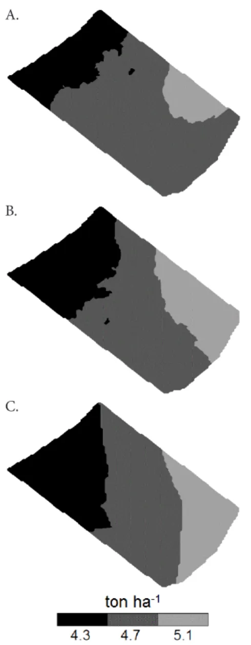
The spatial distribution maps of lime requirement according to the soil sampling using the three grids density tested is observed in Figure 3. It can be observed that by reducing the number of sampled points the proportion of 4.3 and 5.1 t representative classes was increased. This fact indicates that if the soil liming was performed using the grid with fewer sampling points one part of the area would receive less limestone and other part more than necessary.
Representative area percentage values of each class in relation to the total area, each class area (ha) and the required amount of limestone (t) for each class depending on the sampling grid is observed in Table 4. It was observed that as the number of sampled points decrease class 1 (4.3 t) and class
3 (5.1 t) were overestimated, the largest gain was observed for class 3, from 8.55 to 18.6 ha, meaning an increase of 117.5%. The result of the increase in the class 3 area was a gain in the lime requirement amount, which raised from 43.6 to 94.9 t, representing an increase of 117.7%. As the sampled points decreased, it was observed that: a) with the increase of the class 3 area 11% of the total area presented overestimation in the limestone requirement; b) increasing class 1 area 8% of the total area showed sub estimation in the limestone requirement; c) the total limestone amount requirement for the total 90 ha increased from 418.1 to 419.4 t, meaning a gain of 1.3 t.
Although the increase in the total lime requirement amount represents a raise in the cost to the farmer this is not the biggest problem caused by the decrease in the sampled points number. The biggest issue to be highlighted is the loss of productivity that may occur in areas where limestone was applied in smaller or greater amounts than required.
Liming in greater or smaller quantities than required, can result in significant losses in productivity. In case of sub or super estimation of lime requirement amounts the effect of soil acidity or concentration of calcium, respectively, can cause precipitation of important nutrients as phosphorus, zinc, iron, copper and manganese (Novais et al., 2007). Furthermore, the effect of a wrong lime dose can be even more damaging because the lime requirement has been determined using the adequate calcium and magnesium amounts instead of basic cation saturation. The basic cation saturation method could even in saturations below or above the recommended result in maximum production (Kopittke & Menzies, 2007). Moreover, the calcium and magnesium contents must be present to obtain a greater production. This fact can happen because in soils with low cation exchange capacity even if a
Table 3. Cross-validation parameters of theorical models adjustments to empirical semivariance for lime requirement estimated from different sampling grids
Sampling grids(1) Regression coefficient Intercept Standard error (SE) Prediction standard error R²
A 1.08 -0.38 0.20 0.40 0.23
B 0.99 -0.15 0.24 0.40 0.25
C 0.91 -0.43 0.36 0.43 0.21
Figure 3. Spatial distribution maps of lime requirement estimated from the different sampling grids
A.
B.
C.
(1) Lime application of 4,3 t ha-1; (2) Lime application of 4,7 t ha-1; (3) Lime application of 5,1 t ha-1;
*Limestone with PRNT of 100%.
Sampling grids Class 1(1) Class 2(2) Class 3(3) Total
Area porcentage
A 0230. 067.50 09.50 1000.
B 0300. 049.50 20.50 1000.
C 0310. 048.50 20.50 1000.
Area (ha)
A 020.7 060.75 08.55 0900.
B 0270. 044.50 18.50 0900.
C 027.9 43.5 18.60 0900.
Lime amount (t)*
A 89 285.50 43.60 418.1
B 116.1 209.20 94.30 419.6
C 1200. 204.50 94.90 419.4
Table 4. Total area percentage, area (ha) and lime amount (t) for each class according to the different sampling grids density used
high cation basic saturarion, calcium and magnesium contents may not be sufficient. On the other hand, in soils with high cation exchange capacity even with low cation basic saturation calcium and magnesium contents may be ideal. This highlights the importance of the sampling grids density since soils from Brazilian ‘Cerrado’ have typically low cation exchange capacity (Sousa & Lobato, 2004).
In addition, high calcium and magnesium contents could reduce potassium absorption due to antagonistic effect between K and Ca (Pinto et al., 2005; Medeiros et al., 2008), since high calcium amounts could be added in case of super estimation on lime requirement.
Further, in regions where the lime amount is less than necessary, soil pH correction can be compromised. Soils used for grain crops under acidic conditions may have toxic levels of ions such as Al+3 and Mn+2. Moreover soil acidity can affect availability of most nutrients, microorganisms activity, soil structure, soil mineralogy and soil organic matter (Novais et al., 2007). The main conclusion is that the choice of sampling grid density is a fundamental step in planning the liming of soils and deployment of a crop, which may reflect both positively and negatively on productivity of a particular culture.
Further studies on the influence of the density of sampling points on the recommendation of lime application should be performed, to reduce the amount of points without losing accuracy in the mapping.
Conclusion
With the reduction of the sampling points grid density in the soil characterization for lime requirement determination using variable-rate application, 11% of the experimental area showed an overestimation and 8% underestimation comparing with the lime requirement made using the highest sampling grid density.
Acknowledgment
The authors thanks the Brazilian National Council for Scientific and Technological Development (CNPq) for the scholarship and Foundation for Research Support of the Minas Gerais State (FAPEMIG).
Literature Cited
Araújo, S. R.; Demattê, J. A. M.; Garbuio, F. J. Aplicação de calcário com diferentes graus de reatividade: Alterações químicas no solo cultivado com milho. Revista Brasileira de Ciência do Solo, v.33, p.1755-1764, 2009.
Blumfield, T. J.; Xu, Z. H.; Prasolova, N. V. Sampling size required for determining soil carbon and nitrogen properties at early establishment of second rotation hoop pine plantations in subtropical Australia. Pedosphere, v.17, p.706-711, 2007. Brus, D. J.; Heuvelink, G. B. M. Optimization of sample patterns
for universal kriging of environmental variables. Geoderma, v.138, p.86-95, 2007.
Corá, J. E.; Araújo, A.V.; Pereira, G. T.; Beraldo, J. M. G. Variabilidade espacial de atributos do solo para adoção do sistema de agricultura de precisão na cultura de cana-de-açúcar. Revista Brasileira de Ciência do Solo v.28, p.1013-1021, 2004.
EMBRAPA - Empresa Brasileira de Pesquisa Agropecuária. Sistema Brasileiro de Classificação de Solos. 3.ed. Brasilia: Embrapa, 2013. 353p.
Gonçalves, M. L.; Andrade Neto, M. L.; Zullo Júnior, J.; Costa, J.A.F. Classificação não-supervisionada de imagens de sensores remotos utilizando redes neurais auto-organizáveis e métodos de agrupamentos hierárquicos. Revista Brasileira de Cartografia, v.60, p.17-29, 2008.
Isaaks, E. H.; Srivastava, R. M. An introduction to applied geostatistics. New York: Oxford Universit, 1989. 561p. Journel, A. G.; Huiibregts, C. J. Mining geostatistics. Waltham:
Academic Press, 1978. 600p.
Junqueira Júnior, J. A.; Silva, A. M.; Mello, C. R.; Pinto, D. B. F. Continuidade espacial de atributos físico-hídricos do solo em sub-bacia hidrográfica de cabeceira. Ciência e Agrotecnologia, v.32, p.914-922, 2008.
Kopittke, P. M.; Menzies, N. W. A review of the use of the basic cation saturation ratio and the “ideal” soil. Soil Science Society of America Journal, v.71, p.259-265, 2007.
Macedo, M. J. H.; Guedes, R.V.S.; Souza, F. A. S.; Dantas, F. R. C. Análise do índice padronizado de precipitação para o estado da Paraíba, Brasil. Ambi-Agua, v.5, p.204-214, 2010. Medeiros, J. C.; Mafra, A. L.; Albuquerque, J. A.; Rosa, J. D.;
Gatiboni, L. C. Relação cálcio: Magnésio do corretivo da acidez do solo na nutrição e no desenvolvimento inicial de plantas de milho em um Cambissolo Húmico álico. Semina: Ciências Agrárias, v.19, p.93-98, 2008.
Novais, R. F.; Alvarez V., V. H.; Barros, N. F.; Fontes, R. L. F.; Cantarutti, R. B.; Neves, J. C. L. Fertilidade do solo. Viçosa: SBCS, 2007. 1017p.
Pinto, J. C.; Inoue, T. T.; Tormena, C. A.; Costa, A. C. S.; Silva, M. A. G. Mineral composition and dry mass production of corn plants affected by different phosphate sources and different soil aluminum saturation levels. Journal of Plant Nutrition, v.27, p.2149-2158, 2005.
Prado, R. M. A. Calagem e as propriedades físicas de solos tropicais: revisão de literatura. Revista Biociência, v.9, p.7-16, 2003.
Sousa, D. M. G.; Lobato, E. Correção da acidez do solo. In: Sousa, D. M. G.; Lobato, E. (ed.). Cerrado: Correção do solo e adubação. Planaltina: Embrapa Cerrados, 2004. p.81-96. StatSoft, Inc. Statistica (data analysis software system), version
7. http://www.statsoft.com. 2004
Vašát, R., Heuvelink, G. B. M., Borůvka, L. Sampling design optimization for multivariate soil mapping. Geoderma, v.155, p.147-153, 2010.
Weindorf, D. C.; Zhu, Y. Spatial variability of soil properties at Capulin Volcano, New Mexico, USA: Implications for sampling strategy. Pedosphere, v.20; p.185-197, 2010.