Repositório ISCTE-IUL
Deposited in Repositório ISCTE-IUL:
2019-03-18Deposited version:
Post-printPeer-review status of attached file:
Peer-reviewedCitation for published item:
Faria, R., Brito, L., Baras, K. & Silva, J. (2019). Smart mobility: a mobile approach. In Lecture Notes of the Institute for Computer Sciences, Social Informatics and Telecommunications Engineering. (pp. 95-112). Guimarães: Springer.
Further information on publisher's website:
10.1007/978-3-030-14757-0_8Publisher's copyright statement:
This is the peer reviewed version of the following article: Faria, R., Brito, L., Baras, K. & Silva, J. (2019). Smart mobility: a mobile approach. In Lecture Notes of the Institute for Computer Sciences, Social Informatics and Telecommunications Engineering. (pp. 95-112). Guimarães: Springer., which has been published in final form at https://dx.doi.org/10.1007/978-3-030-14757-0_8. This article may be used for non-commercial purposes in accordance with the Publisher's Terms and Conditions for self-archiving.
Use policy
Creative Commons CC BY 4.0
The full-text may be used and/or reproduced, and given to third parties in any format or medium, without prior permission or charge, for personal research or study, educational, or not-for-profit purposes provided that:
• a full bibliographic reference is made to the original source • a link is made to the metadata record in the Repository • the full-text is not changed in any way
The full-text must not be sold in any format or medium without the formal permission of the copyright holders.
Serviços de Informação e Documentação, Instituto Universitário de Lisboa (ISCTE-IUL) Av. das Forças Armadas, Edifício II, 1649-026 Lisboa Portugal
Phone: +(351) 217 903 024 | e-mail: [email protected] https://repositorio.iscte-iul.pt
Ricardo Faria1,2, Lina Brito1,2, Karolina Baras1,2, and José Silva1,3
1 Madeira Interactive Technologies Institute, Polo Científico e Tecnológico da Madeira, Cami-nho da Penteada, 9020-105 Funchal, Portugal
2 Universidade da Madeira, Campus Universitário da Penteada, 9020-105 Funchal, Portugal 3 Instituto Universitário de Lisboa (ISCTE-IUL), ISTAR-IUL, Avenida das Forças Armadas,
1649-026 Lisboa, Portugal
{ricardo.faria, lina.brito, karolina.baras, jose.l.silva}@m-iti.org
Abstract. The Internet of Things (IoT) is one of the key ingredients for the
real-ization of Smart Cities. IoT devices are essential components of the Smart Cities infrastructure, as they can provide information collected from the environment through sensors or allow other systems to reach out and act on the world through actuators. IoT data collection, however, is not limited to sensors and machines, but to data from social networks, and the web. Social networks have a huge im-pact on the amount of data being produced daily, becoming an increasingly cen-tral and important data source. The exploitation of these data sources, combined with the growing popularity of mobile devices, can lead to the development of better solutions to improve people’s quality of life. This paper discusses how to take advantage of the benefits of mobile devices and the vast range of information sources and services, such as traffic conditions, and narrow, closed or conditioned roads data. The proposed system uses a real-time collection, organization, and transmission of traffic and road conditions data to provide efficient and accurate information to drivers. With the purpose of supporting and improving traffic data collection and distribution, an Android application was developed to collect in-formation about extraordinary events that take place in a city, providing warnings and alternative routes to drivers and helping them to improve their time manage-ment. The developed solution also exploits the existing gaps in other applications, implementing a more specific solution for the Madeira Island traffic condition problems.
Keywords: Internet of Things, Smart Cities, Smart Mobility, Mobile
Applica-tions, Sensors, Traffic and Road CondiApplica-tions, Route Planning.
1
Introduction
Over the 20th and 21st centuries, a major change has been taking place in the distribution
of the world’s population as a consequence of the increasing concentrations of people in highly urbanized areas known as megacities [1]. In these very large cities, the com-plexity of building and maintaining infrastructures, and of meeting the needs of a huge and often urban population, has reached new levels.
The rise of megacities has led to drastic changes in travel demand and its structure, related with a fast increase in private vehicle ownership and inadequate extensions of the public transportation system, which has also produced several problems such as traffic congestion, noise, and ambient air pollution. With this unexpected fast urban expansion, traffic has become a big challenge for most of these megacities, and as gines of the global economy, it’s important that the transport network keeps those en-gines working efficiently. But, this continuous growth rate can be seen to have negative and positive effects, as it can create new opportunities for innovation, education, inter-connectivity, and development [2, 3].
To meet the many challenges that megacities are already facing, the usual answer that keeps echoing is to create Smart Cities. So, the expectation of today’s digital age is to combine cities with technological solutions, and if conceived well and designed and built well, Smart Cities could provide relief to megacities that have exceeded their optimum size [4]. This concept not only embodies its technological solutions but also its capacity to manage the information and resources to improve people’s quality of life [5, 6]. Smart Cities effectively could leverage technology, infrastructure, and citizen engagement to create an urban environment that could foster economic growth and productivity, innovation, social mobility, inclusiveness, and sustainability [7].
But the Smart City vision cannot be achieved without a smart and sustainable mo-bility, as it is a key issue and an important motor for growth and progress, crucial for a city to function properly. As mobility problems arise, a massive research effort was gone in the direction of improving urban mobility [8]. This research effort keeps trying to improve road safety conditions and mitigate traffic congestion, especially in large, polluted, and congested cities and in harsh climates with hazardous driving scenarios.
It is difficult to understate how much private vehicles have shaped human societies since cities and infrastructures were built around this paradigm. The land transport sys-tem was mostly based on the use and ownership of private vehicles, consuming on av-erage 85 percent of the total energy used by the transport sector [9]. But, there are too many problems related to vehicle ownership, and there is no more physical space for maintaining the ‘one car, one driver’ combination [10].
Smart Cities and Smart Mobility were set up to tackle the current challenges on that matter, to identify the limitations of our society, and to suggest potential solutions. The implementation of an efficient public transport system could solve part of these prob-lems, but Smart Mobility can go one step further [11]. It could provide a comprehensive and sustainable approach by connecting the use of technology to improve the efficiency of the transport systems (e.g., reducing costs, congestion, accidents, emissions, and in-creasing user comfort) [12]. It also aims to address these issues by applying novel tech-nologies such as sensing, Big Data, IoT and Ubiquitous Computing.
Smart Mobility has been advocated as one of the cornerstones of any forward-think-ing city [13] and regarded as an essential component of Smart City strategies [14]. By addressing the mobility challenges facing people all over the world, Smart Mobility could potentially address the transportation needs by moving people and goods faster, seamlessly and in a convenient way, both in urban and interurban environments [15]. But Smart Mobility has many faces and focus areas depending on local contexts and different needs, which complicates the task of coordinating different, sometimes
contradictory, interests in Smart City concepts. For example, residents and tourists want to reach their destinations on time, but they also want to have an exciting yet relaxed, authentic, and comfortable urban experience [16].
Smart Mobility has also gained momentum in cities around the world because of the widespread use of smartphones, and mobile devices with high computing, storage, and bandwidth capabilities, as well as sensors. In particular, the presence of onboard sensors allows the implementation of mobile applications that can provide useful information and contents to the users, according to their location and current actions [17]. Smartphones are changing the ways we travel, enabling users to consume highly per-sonalized information at any time, in any place. The use of the above-mentioned tech-nologies in transportation systems includes applications for various purposes, such as real-time traffic information, measurement of carbon dioxide emissions, information about roadway construction and incidents, parking availability, and navigation infor-mation for people with accessibility needs [18].
Even though smartphones and their sensors let us monitor specific physical param-eters, such as the user’s location or the user’s activity recognition, the Internet is also another source of valuable data. If properly collected and delivered, it can contribute to solving many problems related to user’s mobility in the cities. One of the most inter-esting research issues is to predict traffic flow by extracting traffic-related information such as congestion and incidents using textual data from the Internet. By analyzing social media, and other sources on the Internet it is possible to know beforehand, where an accident happened, or which road is closed for maintenance, helping to predict the traffic flow on those roads. It can also be made using data shared by users in many applications, such as Google Maps and Waze, or by organizations responsible for traffic management.
In their daily lives, citizens frequently experience unexpected situations while driv-ing, like suddenly finding interrupted roads due to works or other types of extraordinary events, like sports events, happening in the city, forcing them to quickly decide which alternative road to get to the intended destination on time. Because of these situations, driving can be an emotionally stressful experience. Hernandez et al. [19] measured the stress of drivers through different types of interactions and stated that stress in large doses leads to adverse health conditions such as depression, hypertension and various forms of cardiovascular disease. So, to avoid getting stressed, a driver might prefer the least stressful route, even if it is not the fastest route.
In this sense, a platform is proposed to use technologies to support decision-making, improving user’s mobility and helping citizens to optimize their time management, con-sequently reducing their daily stress. This platform aims to centralize all the existing information about traffic and roads condition for the Madeira Islands, a Portuguese ar-chipelago, located in the North Atlantic Ocean, southwest of Portugal. Even though the Madeira Islands does not have a single, large megacity like London or Paris, it has its own mobility problems, which are not so different from the issues previously men-tioned for other large cities. Almost half of Madeira’s 270,000 population lives in Fun-chal, the island’s capital. In this city, the narrow, cobbled streets were never meant for vehicles, usually being surprisingly congested with traffic. Road congestion is very common in many parts of the city, especially in the center at various times of the day.
In the morning, for example, the main access roads are very close to their capacity, or even exceed it, leading to congestion that also affects the performance of public transport. Exploring the island to the north is also difficult because of the steep and winding terrain. Parking is also a problem felt by everyone, namely drivers and pedes-trians. In almost every place in Funchal, there are more vehicles parked on the road than on legitimate parking spaces [20]. Consequently, in order to solve some of these problems, an Android application has been developed to collect traffic-related data, by using information shared by users on Facebook or in municipalities and governmental websites.
The current sources of data are obtained through Madeira Civil Protection Services [21] and from some Facebook pages [22] where users post news about accidents and other incidents on the road. Civil Protection data is more reliable than Facebook data and is used to find information about closed or conditioned roads in advance. In turn, Facebook allows us to get crowdsourced data about accidents and traffic congestion in real-time. A server collects and filters the traffic information data, obtaining the event location coordinates and distributing this data to the application. The application then notifies the users about these events and provides alternative routes if necessary. It also provides a navigational solution with additional features such as elevations, narrow-ness, and steepness of roads.
The remaining paper is structured in five different sections. Section 2 provides a current state of research, describing the existing systems related to this work. After the second section, there is a short description of the issues and problems that led to the development of this paper. Then the proposed system, as the design and methodologies used were described. Next, there is a discussion section to explain the obtained results, their limitations, learned lessons and directions for future improvements. Finally, a short conclusion summarizes this paper key findings.
2
Literature Survey
There is hardly a country in Europe in which urban mobility does not pose a challenge in the 21st century. Because of this problem, mobility in urban environments has
be-come one of the most prominent research fields in the Smart City context. Therefore, different research papers and applications have been dedicated to finding solutions to those traffic-related problems.
Khatri [23] proposed a traffic monitoring system to extract traffic information data such as congestion and incidents using textual data from the Internet. To pursue this task the authors used Twitter social networking as the primary data source, in such a way that the system can detect traffic congestions and traffic incidents from the users’ tweets. It extracts as much information as possible using people as sensors, instead of setting up a dedicated infrastructure for the same purpose. It follows the idea that people tend to share with others the events that occur around them, so they also share traffic-related information. By another side, Chatterjee et al. [24] created an online interface to access the dynamic real-time data from the Facebook pages about Indian cities traffic (using the Facebook API). The Facebook API helps to extract different attributes of
online pages dynamically to explore the status and quality of traffic in real-time. An-other example of using social media in traffic-related applications is the solution pro-posed by Zhang et al. [25], which consists on mining social media data to deduce useful related traffic information with a special emphasis under events, including both planned events (such as sporting games), and unplanned events (such as traffic accidents). Hence, Twitter, Facebook, Instagram, Snapchat, and other social media websites can act as new platforms for data, where people themselves act as sensors and share the information which they possess.
Similarly, the proposed platform was developed with non-traditional data sources, using Madeira Civil Protection Services and Facebook data. To accomplish this goal the analysis initially leveraged data that included geolocation information. Many people share on Facebook traffic incidents and other traffic-related events which they find on the go. This information is very important as it can be used to identify traffic congestion and other traffic-related data, almost in real-time.
Singh et al. [26], Allouch et al. [27], and Bhoraskar et al. [28] present different solutions to detect the road surface conditions. The first one uses a smartphone-based sensing and crowdsourcing technique to detect the road surface conditions like potholes and bumps, based on the analysis of accelerometer readings. An Android application was developed to interact with the sensors of the smartphone to collect accelerometer and GPS data. Those smartphones were placed inside the vehicle at different positions (front dashboard or backseat), and when the vehicle experience a pothole or bumps the accelerometer sensor records these variations. RoadSense [27], based on The Pothole Patrol application [29] is a road condition monitoring framework based on smartphone built in sensors (accelerometer, gyroscope, and GPS) to analyze the quality of different road sections using machine learning techniques. By using this machine-learning ap-proach, the application can identify potholes and other severe road surface anomalies. This framework employs unimodal accelerometer data, using a gyroscope sensor in conjunction with the accelerometer to derive more accurate road quality predictions. Wolverine [28] also use smartphone sensors (accelerometer, GPS, and magnetometer) for traffic and road conditions detection. This method was specifically designed to iden-tify braking events, that frequently indicates congested traffic conditions, and bumps on the roads to characterize the type of road. It also applies machine learning techniques to classify the data to adapt to changing factors like the nature of the road and the type of vehicle.
Unlike the previously presented studies that use sensors to detect potholes, the pro-posed platform uses data retrieved from Facebook posts about potholes and other severe road surface anomalies. It also retrieves data from rockfalls and landslides, problems that extend to the whole island, especially in Winter. In Madeira Island, after the bad weather, it is normal that numerous sections of the regional roads are closed because of the rockfalls. The developed platform does not use any method to detect surface condi-tions, but in future it could be integrated in our solution. Our main goals for the appli-cation were to get the roads width (provided by Funchal’s City Council), slope (re-trieved from the MapQuest’s Open Elevations API [30]), and to get information about traffic conditions (obtained through Madeira Civil Protection Services and from Face-book traffic-related pages).
Google Traffic and Waze are the most popular applications for real-time traffic con-ditions based on user contributions. Google Traffic is a feature on Google Maps that displays traffic conditions in real-time on major roads and highways. It works by ana-lyzing the GPS-determined locations transmitted to Google by many mobile phone us-ers. By calculating the speed of users along a length of road, Google can generate a live traffic map. Google processes the incoming raw data about mobile phone device loca-tions and then excludes anomalies such as a postal vehicle that makes frequent stops. When a threshold of users in an area is noted, the overlay along roads and highways on the Google map changes color. In turn, Waze allows users to avoid traffic jams, police traps, and accidents. It is a community-driven GPS navigation application, providing turn-by-turn navigation information. It automatically reroutes around traffic as condi-tions change on the road and help users to find gas stacondi-tions and the cheapest gas prices.
The applications mentioned above solved several traffic-related problems, also in-forming drivers about traffic conditions, and providing turn-by-turn navigation. But the existing applications do not work in a perfect manner for the Madeira Islands, and this was one of the motivations for the development of this study. The pros and cons of each application, namely Google Maps and Waze, will be better explained in the Problem Statement section.
3
Problem Statement
Smart Mobility, which is related to traffic conditions, is one of the key factors for the development of Smart Cities and is one of the biggest challenges of the 21st century.
Traffic congestion, roads interrupted due to works, sports events or festive celebrations are some of the situations that influence the way drivers move through the cities. These unexpected situations require drivers to find fast solutions to reach their destinations on time.
With a focus on improving mobility and reducing daily stress, it provides a service for more efficient time management. In their daily lives, citizens frequently experience unexpected situations while driving, like suddenly finding interrupted roads due to works or another type of extraordinary events, happening in the city. When using the current GPS navigation systems, this problem can be minimized since they suggest al-ternative routes to the drivers. However, most people have probably experienced situa-tions where GPS navigation systems have not been updated to accommodate the most recent changes in traffic, by not anticipating traffic congestions and traffic incidents, or that take drivers into extremely narrow streets, where a car barely fits, or into the middle of a forest. Moreover, current navigation systems do not consider the slope of the road, which could also be a problem, especially if drivers are taken to very steep roads. There-fore, it is so important to develop solutions to anticipate and alert users about these conditions.
Fig. 1. Madeira Island and Funchal city topographic maps
Madeira is a mountainous island (see Fig. 1), dominated by a vigorous volcanic land-scape, with deep valleys steeped slopes and scarps. Only 16 % of the island has a gra-dient of less than 30º. Flat terrain and sandy beaches are almost inexistent [31]. In Ma-deira, there is a rather peculiar and dangerous road called Estrada Regional 101 (ER101). It is one of the oldest and most beautiful roads of the island. Due to Madeira’s dramatic coastline, the road has many curves, narrow passages, and steep climbs and descents, and is rugged, slow and old. Due to the many views on the coast and the Atlantic Ocean, this road is frequently taken by tourists. Even though passing close to the sea, it looks more like a mountain road, and from time to time the road gets very narrow, especially on the North coast of the Island. This road is considered one of the most dangerous roads in the world, as stated by dangerousroads.org [32] users.
During the last decades, there has been massive construction in several areas of Ma-deira, particularly on the areas surrounding Funchal, and the network of paved roads and the construction of several tunnels expanded considerably leading to a higher mo-bility of people and goods throughout the island and the possimo-bility to reach once inac-cessible areas. But, Madeiran cities, such as other European cities, are still struggling with traffic congestion. In Funchal, the capital city of Madeira island, traffic congestion problem has grown to alarming proportions, and it is one of the most challenging issues. The causes of traffic congestion in Funchal are many. Its orography with narrow and steep roads does not let the traffic flow smoothly. There are many schools in Funchal center and traffic becomes chaotic when parents take and pick their children up from school. Also, as in other cities, people from other areas of the island come and get back to their home villages once they finish their day-to-day work, which only causes even more traffic. The heavy traffic entering and exiting the island's main road (VR1 – Via Rápida 1) typically leads to congestion on the entrance and exit ramps that give access to the Funchal’s center (see Fig. 2).
Fig. 3. Google Traffic in Madeira Island
Another motivation to start this project was the lack of information about traffic condi-tions in Funchal. Google Traffic displays the traffic condicondi-tions in real-time, considering the users flow on a certain stretch of road, and takes advantage of the users’ smartphones to calculate the vehicles speed along the road. However, for certain areas, it only has information about major roads. And when the project was started it was even worse, only showing information about one of the main roads of the island (see Fig. 3). Other problems found were that it does not display closed or conditioned roads, does not consider the road conditions (e.g., potholes) and it does not provide users additional information about the roads (e.g., roads width, pavement type, condition, etc.).
Fig. 4. Waze in Madeira Island
Other possible solution could be Waze (that allows sharing traffic information in real-time, being updated by users, by adding multiple traffic-related events, like accidents, or closed roads. But in Madeira island, there is a lack of users and contributions. Only one closed road is marked down on the island map by a contributor that probably went there on holidays (see Fig. 4). Besides that, the information becomes outdated as there are no contributions, and no one controls those contributions. Furthermore, there is im-precise information on the map (e.g., wrong road names, etc.). The applications men-tioned above, when the project was started, they had the same problem, the lack of users, which meant that the applications had few information about the real traffic con-ditions.
ProCiv Madeira [33] is an application developed for Madeira Civil Protection (see Fig. 5) that provides information about closed roads or accidents, that are shared by Madei-ran municipalities and government websites. However, it does not provide traffic-re-lated information in real-time.
Other issues found in the previously mentioned systems are:
• Driving users to steep roads. With winding mountain roads and vantage points that overlook the sea, driving in Madeira can be a challenge both for tourists and locals. A continuous maze of roads which take drivers up and down on close to 90 degrees steep (up and down) hills;
• Driving users to narrow roads. In the older urban zones, driving can be stressful. The road lanes are narrow, there are cars parked on the sides and there are many junctions with priorities difficult to understand;
• Especially tourists that are unfamiliar with the island or some part of the island, are often in need of help to take their rental cars from some roads;
Furthermore, in an island where from time to time there are rock falls, that lead to road closures, it is even more important to alert drivers before they get on the road to their destinations.
4
Proposed System
Based on the initial findings and identified challenges described in the previous section, a platform that uses mobile technologies were developed to support decision-making, improving users’ mobility and helping citizens to optimize their time management, con-sequently reducing their daily stress. The proposed system automatically gathers roads traffic information from several sources and transmits it to the users’ smartphones. This collection of information focus on the events that are occurring inside the city, that could influence the traffic.
The application was developed for Android Operating System, showing information on a map about closed or conditioned roads, and integrating information about inter-rupted roads and changes in the direction of traffic. This mobile application allows sending notifications to the users about road conditions, based on the regular itineraries of the users.
Based on sensor data and information available on maps, the platform collects both geographic and orographic information, alerting the users about the existence of narrow or steep roads in a certain path.
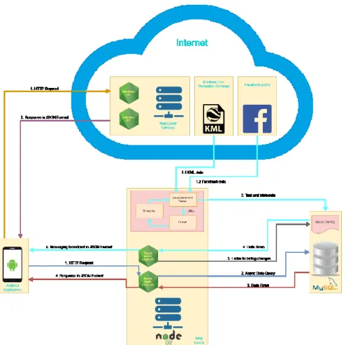
The system architecture (see Fig. 6) is divided into three major modules: the server, the database and the Android application, all of which are explained in detail in the next three sub-sections.
Fig. 6. Developed System Architecture
4.1 Node.js Server
The server was built on Node.js because it is completely event driven and much of the code runs basing on callbacks, which helps the application not to pause or sleep, but to become available for other requests. Its main function is to parse HTML infor-mation about events, such as interrupted roads and changes in the direction of traffic, that is currently available on several websites. To not have this script always running on the server, the node-cron package was used that schedules the parsing of the web pages related with traffic, every day at the same hour. This is a way to run functions at specific times of the day, week, month or year. The Cheerio package was used to make the HTML parsing. It allows to parse, to manipulate, and to render the DOM data struc-ture from the websites HTML documents. More precisely, it retrieves all the data avail-able on the municipalities and government websites related with closed or interrupted roads, and then, sends it to the users’ smartphones. It also saves the begin and the end GPS coordinates of the closed road sections, updating the mobile phones whenever a new event occurs.
The server gathers data from the devices that are accessing it to better give alerts to the user himself, and to the other users too. For that, it uses web sockets, more precisely Socket.io package that allows the server to communicate with the Android smartphones and enables real-time bidirectional event-based communication. It collects data from the smartphones using three identifiers, that together are unique: the smartphone brand, model, and serial number. This is a way to differentiate each access to the server.
It also collects real-time data about accidents, to inform the users about low traffic flow on the road and helping the drivers to choose another route to their destination.
4.2 Database
MySQL was the chosen database management system. It stores data about the width of the roads, as well as other road and traffic conditions. By using alerts, this data will help users to avoid roads where accidents have occurred, where there is a high traffic density or narrow or steep roads. If the users request a route on the application, it will send an HTTP request to the server to retrieve the width of each road. The data is re-trieved in JSON, that is a lightweight data-interchange format.
The MySQL database is replicated using the binary log. This replication is im-portant to achieve high availability and to record all changes made to the database along with additional information related to those changes such as time taken to for a state-ment to update date, etc. The binary log is not only used for replication but can be used for auditing and point in time recovery. By using bin log listeners like Zongji or LiveSQL, it’s possible to capture every change made on the MySQL binary log. In this way, every time there is new data on the closed roads table, an alert is generated to the server and then the data is broadcast to all the application users.
4.3 Android Application
This application collects information about extraordinary events that take place in a city (works, sports events, celebrations, etc.) integrating information about these events, like interrupted roads and changes in the direction of traffic, that is currently spread across several websites where this information is usually published (municipality and govern-ment websites). This application also collects and provide useful information about in-teresting events taking place in the city.
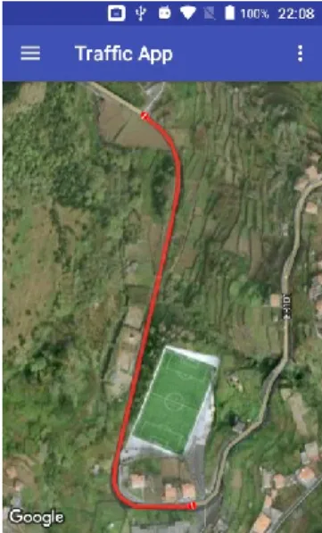
The first problem found was about the dispersion of information found on the Inter-net about the condition of the roads and which ones are closed or conditioned. To solve it, the Android application shows on the map (see Fig. 7), the sections of closed or conditioned roads, sending notifications to the users about the roads that are in works or that are closed. Additionally, it sends notifications about events that will occur, to inform users which roads will be closed and when.
To determine the users’ location, the smartphones GPS is used. This will help in the future to send personalized notifications to the users, considering their previous loca-tions and routes. It is crucial to only send notificaloca-tions to the users that are relevant for them. For example, if the user never goes to a certain location, probably he would not want to know if there is a closed road there.
Fig. 7. Closed Road in Madeira Island
By determining if the Wi-Fi network that the user is accessing is one of the known networks (home, work, etc.), and because GPS and other sensors consume too much energy, when the user is connected to a known Wi-Fi network, all the sensors are off, decreasing the unnecessary usage of sensors indoors to reduce the energy consumption.
To get the slope of the roads the Open Elevation API [30] was used. It provides eleva-tion profile informaeleva-tion such as elevaeleva-tion and distance given a latitude/longitude pair in JSON format. Having the elevation and distance between coordinates the slope of the road is calculated. Fig. 8 shows an example of a steep road, and how the application indicates on the map the steep percentage and degrees.
To send notifications to the users in an adequate way, the Activity Recognition plugin developed by Aware Framework [34] was used. This plugin aims to accurately detect users’ activity such as walking, running, driving, etc. Essentially, the app only needs to know if the user is driving or not. If he is, the smartphone reads the notification to the user, using the Text-to-Speech from Google and it does not disturb user’s driving. If not, then the notification is sent as text, in a way that the user could read it anywhere and anytime. This plugin aims to reduce distractions on the road by sending audio no-tifications to the driver.
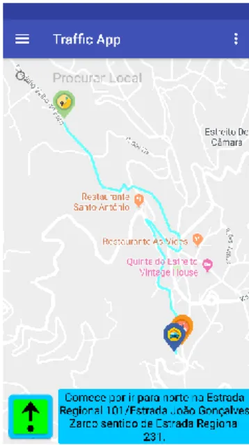
Fig. 9. Turn-by-turn navigation
The application also provides a turn-by-turn navigation (see Fig. 9), using the Mapquest Directions API [35], where the maneuvers for each interception are continu-ously presented to the user in the form of textual or audio instructions. This module requires GPS to be enabled as it needs to know the exact location of the user to provide the maneuvers to be performed.
5
Discussion
The implementation of the application was done using the AWARE Framework, and while the server collects and filters the data, the application shows the filtered data to the user. The application was tested to obtain information about local events, and if there were some real-time events occurring on the route to our destinations.
While the information from the Civil Protection website, is successfully obtained and shown to the user, by marking closed roads on the map and by notifying the user about these events in advance, the information obtained from the Facebook needs to be filtered. However, it is impossible to obtain only the relevant and accurate information, as it depends on what the users posted.
Although this solution can solve some of the issues related to traffic problems, it is still a prototype, and as solutions are found more new problems arrive. The future de-velopment will lead to a more robust solution, in order to help all of them who stress when they are on the road.
Currently, the application has only width data about the Funchal city. If we trace a route outside Funchal there will be no data, and then the width of the roads will not be shown in the application map. Another problem related to roads width that this solution cannot solve is when drivers park their cars on the road making it difficult for other drivers to pass on that road. By using IoT technologies it could be possible to know where a car is parked, or if there is no space for other vehicles to pass.
One problem, that is difficult to solve, and happened during the application devel-opment, is related to HTML parsers. While server is parsing to get the data, if the owner of the website decides to change the DOM of the webpage document (a cross-platform and language-independent application programming interface that treats an HTML, XHTML, or XML document as a tree structure wherein each node is an object repre-senting a part of the document), then the script to read that webpage must be redone. One possible solution could be to suggest to the website owners the uniformization or the best distribution of the data, for example by using web services.
Currently, our platform collects data only for Madeira Island, but it can be expanded to integrate other data sources related to other locations traffic and road conditions.
The application was only tested with three smartphones: ONN V9 Only with An-droid KitKat, Samsung Galaxy S6 Edge with AnAn-droid Nougat and Alcatel PIXI 4 with Android Marshmallow. Another problem related with Android versions and the innu-merous smartphones available, and because it will be impossible to test the application in each different mobile device, is that our application could not work on some smartphone’s brands and/or Android versions. Regarding the Operating System (OS), the application is restricted to Android smartphones and future studies could implement software for another OS.
As the development of the application started with previous versions of Android, the battery-saving features were not a problem. Android Marshmallow introduced a pair of new battery-saving features called Doze and App Standby, that used to kill some background processes that were consuming more battery than normal. One of the fea-tures used was Socket.io that uses web sockets, and because it maintains a
communication tunnel open, Doze tends to shut down the process that is using this feature, causing the app to crash.
Current studies and applications solve a range of traffic-related problems. But there are specific problems, for certain areas of the world, where those applications are al-most useless. This force researchers to create specific solutions for certain areas of the world. Madeira island, with its orography, narrow and steep roads, is a very peculiar scenario for this kind of apps and more generic solutions are not adequate. Neverthe-less, we based our development on these apps, and it was much better than having to start from scratch.
One of the challenges of this type of studies is to get out and test the application while driving on the road. Each time a bug appears, it needs to be solved by returning to the computer. It could be easier for developers to change their own scripts directly on the mobile device.
Another challenge was to collect the data from the websites and to extract only the relevant information. Some websites have all the information well-organized, but for others, it must be done manually.
6
Conclusion
Smart Cities depend on solutions that can reduce and optimize the traffic on their streets. The implementation of smart solutions that integrate mobile phone sensors with environment sensors, can transform the way drivers see the traffic, avoiding certain problems that only increase the stress of whoever is on the road. Knowing these situa-tions in advance will give drivers some more time and comfort.
The design and implementation of an Android application to help users to avoid certain types of roads and events, using data retrieved from the Internet were presented. The application was created to a point where all the functionalities for using the infor-mation from the closed and conditioned roads were completed. Other functionalities include displaying the location of the narrow or steep roads.
For future work, the next steps will focus on taking advantage of additional data sources of real-time data about traffic density, potholes, and free parking spaces. Other objectives will be to use the data collected by the smartphone sensors to know the user habits (routes used, frequently visited places and so on) to issue only relevant notifica-tions for each user. Lastly, it will be important to ask users their opinion about each route. In this way, it will be possible to identify road problems that were difficult to detect through the sensors (e.g. potholes).
Other future implementations will include options to know the preferences of the drivers while parking their cars (e.g., the closest parking lot to their destination or the cheapest) and give information to the users about where they can park their cars (some-times users do not know about some parking lots that can be closer to their destinations or cheaper than the ones where they are actually parking).
Acknowledgments
This research has been supported by FCT – Fundação para a Ciência e Tecnologia, within the Project Scope: UID/EEA/500009/2013.
References
1. United Nations, Department of Economic and Social Affairs: World urbanization prospects, the 2014 revision: highlights. (2014).
2. Jerzy, K., Anna, N.K.: Rise of Megacities, The: Challenges, Opportunities and Unique Character-istics. World Scientific (2018).
3. van der Ploeg, F., Poelhekke, S.: Globalization and the rise of mega-cities in the developing world. Cambridge Journal of Regions, Economy and Society. 1, 477–501 (2008).
4. Pelton, J.N., Singh, I.B.: Smart Cities of Today and Tomorrow: Better Technology, Infrastructure and Security. Springer (2018).
5. Ramaprasad, A., Sánchez-Ortiz, A., Syn, T.: A Unified Definition of a Smart City. In: Janssen, M., Axelsson, K., Glassey, O., Klievink, B., Krimmer, R., Lindgren, I., Parycek, P., Scholl, H.J., and Trutnev, D. (eds.) Electronic Government. pp. 13–24. Springer International Publishing, Cham (2017).
6. Zubizarreta, I., Seravalli, A., Arrizabalaga, S.: Smart City Concept: What It Is and What It Should Be. Journal of Urban Planning and Development. 142, 04015005 (2016).
7. Khanna, P.: Urbanisation, technology, and the growth of smart cities. Asian Management Insights. 52–59 (2015).
8. Panigrahi, C.R., Pujari, A.K., Misra, S., Pati, B., Li, K.-C.: Progress in Advanced Computing and Intelligent Engineering: Proceedings of ICACIE 2017. Springer (2018).
9. Rodrigue, J.-P., Comtois, C., Slack, B.: The Geography of Transport Systems. Routledge (2006). 10. Neckermann, L.: Smart Cities, Smart Mobility: Transforming the Way We Live and Work.
Trou-bador Publishing Ltd (2017).
11. Baucells Aletà, N.: SMART MOBILITY IN SMART CITIES. In: Libro de Actas CIT2016. XII Congreso de Ingeniería del Transporte. Universitat Politècnica València (2016).
12. Bazzan, A.L.C., Klügl, F.: Introduction to Intelligent Systems in Traffic and Transportation. Mor-gan & Claypool Publishers (2014).
13. Koch, F., Meneguzzi, F., Lakkaraju, K.: Agent Technology for Intelligent Mobile Services and Smart Societies: Workshop on Collaborative Agents, Research and Development, CARE 2014, and Workshop on Agents, Virtual Societies and Analytics, AVSA 2014, Held as Part of AAMAS 2014, Paris, France, May 5-9, 2014. Revised Selected Papers. Springer (2015).
14. Benevolo, C., Dameri, R.P., D’Auria, B.: Smart Mobility in Smart City. In: Torre, T., Braccini, A.M., and Spinelli, R. (eds.) Empowering Organizations. pp. 13–28. Springer International Pub-lishing, Cham (2016).
15. Portland State University, Golub, A.: Community-Based Assessment of Smart Transportation Needs in the City of Portland. Transportation Research and Education Center (2018).
16. Flügge, B.: Smart Mobility – Connecting Everyone: Trends, Concepts and Best Practices. Springer (2017).
17. Amoretti, M., Belli, L., Zanichelli, F.: UTravel: Smart Mobility with a Novel User Profiling and Recommendation Approach. Pervasive and Mobile Computing. 38, 474–489 (2017).
18. Gebresselassie, M., Sanchez, T.: “Smart” Tools for Socially Sustainable Transport: A Review of Mobility Apps. Urban Science. 2, 45 (2018).
19. Hernandez, J., McDuff, D., Benavides, X., Amores, J., Maes, P., Picard, R.: AutoEmotive: bringing empathy to the driving experience to manage stress. In: Proceedings of the 2014 companion pub-lication on Designing interactive systems - DIS Companion ’14. pp. 53–56. ACM Press, Vancou-ver, BC, Canada (2014).
20. Berlitz: Berlitz: Madeira Pocket Guide. Apa Publications (UK) Limited (2014). 21. Home - Serviço Regional de Proteção Civil - Madeira, https://www.procivmadeira.pt/pt/. 22. Ocorrências na Madeira, https://www.facebook.com/groups/ocorrencias.madeira/?fref=nf. 23. Khatri, C.: Real-time Road Traffic Information Detection Through Social Media.
arXiv:1801.05088 [cs]. (2018).
24. Chatterjee, S., Mridha, S.K., Bhattacharyya, S., Shakhari, S., Bhattacharyya, M.: Dynamic Con-gestion Analysis for Better Traffic Management Using Social Media. In: Satapathy, S.C. and Das, S. (eds.) Proceedings of First International Conference on Information and Communication Tech-nology for Intelligent Systems: Volume 2. pp. 85–95. Springer International Publishing, Cham (2016).
25. Zhang, Z., Ni, M., He, Q., Gao, J.: Mining transportation information from social media for planned and unplanned events. (2016).
26. Singh, G., Bansal, D., Sofat, S., Aggarwal, N.: Smart patrolling: An efficient road surface moni-toring using smartphone sensors and crowdsourcing. Pervasive and Mobile Computing. 40, 71–88 (2017).
27. Allouch, A., Koubaa, A., Abbes, T., Ammar, A.: RoadSense: Smartphone Application to Estimate Road Conditions Using Accelerometer and Gyroscope. IEEE Sensors Journal. 17, 4231–4238 (2017).
28. Bhoraskar, R., Vankadhara, N., Raman, B., Kulkarni, P.: Wolverine: Traffic and road condition estimation using smartphone sensors. In: 2012 Fourth International Conference on Communication Systems and Networks (COMSNETS 2012). pp. 1–6. IEEE, Bangalore, India (2012).
29. Eriksson, J., Girod, L., Hull, B., Newton, R., Madden, S., Balakrishnan, H.: The pothole patrol: using a mobile sensor network for road surface monitoring. In: Proceeding of the 6th international conference on Mobile systems, applications, and services - MobiSys ’08. p. 29. ACM Press, Breckenridge, CO, USA (2008).
30. Open Elevation API - Overview, https://developer.mapquest.com/documentation/open/elevation-api/.
31. View of Modelling Tourism Demand in Madeira Since 1946: And Historical Overview Based on A Time Series Approach, https://www.jsod-cieo.net/journal/index.php/jsod/article/view/68/66. 32. ER101 Antiga,
https://www.dangerousroads.org/europe/portugal/115-er101-antigua-portu-gal.html.
33. ProCiv Madeira - Apps on Google Play, https://play.google.com/store/apps/de-tails?id=com.dobsware.procivmadeira&hl=en.
34. AWARE – Open-source Context Instrumentation Framework for Everyone, http://www.aware-framework.com/.
35. Open Directions API - Overview, https://developer.mapquest.com/documentation/open/direc-tions-api/.