1
Geo Wars
–
The development of a
location-based game
Geo Wars – O desenvolvimento de um jogo baseado na localização
João Tiago Pinheiro Neto Jacob
Faculdade de Engenharia, Universidade do Porto [email protected]
António Fernando Coelho
Faculdade de Engenharia, Universidade do Porto / INESC Porto [email protected]
Resumo
Com o aparecimento de novos dispositivos móveis como smartphones, tables e PDAs, surgem também novos paradigmas de interação para utilizadores e programadores explorarem. Estes dispositivos permitem que sejam criadas aplicações únicas graças ao vasto número de sensores e mecanismos de entradas que possuem (como GPS, acelerómetros, entre outros). Assim, experiencias ubíquas e personalizadas tornam-se possíveis. Jogos móveis baseados na localização não se limitam a copiar mecanicas de jogo já existentes em jogos de consola/computador. Pelo contrário inovam, permitindo experiencias únicas e personalizadas. Este artigo apresenta um jogo móvel baseado na localização: desde a fase de desenho e implementação à fase de testes do mesmo.
Palavras-chave: Jogos Móveis; Serviços de localização; GPS; Dispositivos móveis.
Abstract
As new, more powerful, mobile devices, such as smartphones, tablets and PDAs arrive, so do new ways of interaction for the users and developers to explore. These devices allow for the creation of never-before-seen applications, using the broad range of inputs and sensors these devices posses (such as accelerometers, light sensors, compasses, GPS sensor among others), that allow for more ubiquous and personalized experiences. Mobile location-based games are such applications, not being limited to copying previous console/computer games and their concepts, but rather inovating them so as to provide different and unique gaming experiences.
Keywords: Mobile games; Location awareness;
2
1. Introduction
All software that is created follows a given methodology. The interactive entertainment
industry, more commonly known as game industry is no different. Some methodologies,
such as sashimi or the spiral/iterative model (Araújo & Roque, 2009) help determine what
aspects of the project should be altered, added or removed by analysing the end result (or,
in case of the sashimi model, the result of a given phase). As important as this is in the
software industry, its importance is even greater in video games, as these are often complex
and unpredictable. Even more unpredictable are the location-based games, as these games
el upo lo atio data, su h as the pla e ’s eal positio , as a ea s of i put o as a ea s of ge e ati g o usi g ga e spe ifi o te t. As su h, the pla e ’s ga e e pe ie e a
differ, not only from player to pla e , ut f o lo atio to lo atio , e pa di g the ga e’s
possibilities and longevity. Since these games rely upon location services to work (or, in their
simplest of forms, just a positioning system such as a GPS module) they are almost
exclusively available in mobile platforms, since these are the most prone to be more up to
the task, as they have both the necessary services, and as they are by definition mobile, the
game can be played easily in several locations or even while the player is moving himself.
However, certain problems are due to arise from the usage of such dynamic information as
location based one. Location based games become often unplayable in situations where the
location services are somehow inoperative (such as inside buildings when the GPS module is
incapable of getting a satellite fix) or when the location-based data is unavailable or poor for
that particular location (as when there is no information the game may use for a specific
location, or the information provides a bad user experience). Also to be considered is the
ga e ’s ph si al o ditio .
This paper presents a location-based game called Geo Wars and all of its phases of design,
development, implementation and testing. The following chapters will cover the actual
state-of-the-art of location-based games, some of the issues present in these games, the
game's mechanics, the game's architecture, the game's development and finally, the
3
2. Location-Based Games
A Location-based Game is a ga e that uses the pla e ’s ph si al lo atio o a othe
location) as a means of input or to generate or access location-based information. These
games are almost exclusively available on mobile platforms [MGD]. Location-based games
ha e ’t ee a ou d for too long. In fact, they would only see any commercial use in 2002
with the arrival of Botfighters [BotFig], the first pay-per-locate GPS game. The concept was
simple: each player was a robot with the mission of destroying the enemy robots. For each
kill the pla e ould e a a ded edits hi h ould e spe t o the ga e’s e site to
further improve his killing machine. In order to play the game, the player would move
around the city, scanning for enemy robots (which would be other players with the same
goal . Whe a e e o ot as i a ete adius of the pla e ’s positio , a “M“
based exchange of fire would commence. The effectiveness of the shoots would be greater
as the distance between target and shooter shortened. This allowed for a kind of tag game,
as players often would engage in urban pursuits, chasing and running away from attackers.
With the birth of of this genre only roughly eight years ago, location-based games have now
gained a considerable popularity. For an instance, Geocaching [GeoCa], probably the most
popular of geocaching games, claims to have more than a million registered users. The idea
ehi d it is e e si ple : a pla e stashes a a he ith o te ts i a o da e ith the geo a hi g’s ules a he e i the o ld a d sha es it’s app o i ate lo atio ith othe
geocachers around the globe. Other players will attempt to discover this cache by solving
some riddles and exploring the general area the cache is known to be. After finding the
cache they may exchange an item, pa t of the a he’s o te t, ith a o ed ite . This
game is widely played not only due to its simplicity and likeness to treasure hunting games,
ut also e ause it does ’t e essa il e ui e a GP“ apa le de i e, as pla e s a e
already familiar with the general area of the cache prior to going to find it. After finding a
a he the pla e a etu to the ga e’s e site i o de to update his t a k of fou d
caches and to provide feedback to the player that created that particular adventure by
stashing the cache.
Of course other games, although using the physical location of the player, need to be played
with a mobile location-capable device. Pac-Manhattan [PacMan] is such a game. In it, players
4 be Pac-Man, four other to be ghosts, and the remaining five to control and coordinate the
actions of the others via mobile phone. As the Pac-Man player wanders around the streets of
a real city, the player responsible for controlling him will guide him through the streets,
avoiding the ghosts and, of course, eating pellets. The other coordinators will attempt to
guide the ghost players in order to trap (or if Pac-Man has eaten a big pellet, to escape) the
Pac-Man player. Only the coordinators have, in their mobile application, the full picture, the
aze a d all the fi e pla e ’s positio s i the ga e. The eal fi e pla e s ha e o pi tu e of
the game, other than being themselves on the terrain.
As location-based games gained popularity, several platforms of mobile games emerged,
with two having a particular success. One of them is Groundspeak [GroSp], the platform that
contains not only the Geocaching game, among others, but also the Whereigo [WiGo] tool, a
tool for creating and playing GPS-enabled games [WiGo]. The other, Locomatrix [LoCo],
currently in quick expansion, offers two games: Treasure hunt, a geocaching like location
based game, with a more virtual component, as the player has to use pictures to solve
riddles a d fi d pla es, a d f uit fa e , a ga e he e the pla e ust olle t f uits
around him by moving around in the real world, avoiding also having these fruits stolen by
other farmers. As it can be seen, location-based games have come to be quite a success from
thei o igi s i the ea l . These ga es’ o u ities g o igge e e da , ith
increasingly more new location-based games being added to these platforms.
3. Issues in the Development of Location-Based Games
The core of the mechanics of a location-based game is the location component and some
other derived issues. The problem is rarely how to integrate location-based information into
a ga e’s logi , ut athe the a essi ilit of that i fo atio a d the u p edi ta ilit that
follows its integration. Most location-based games rely upon the GPS module available on
s a t pho es i o de to p o ide the pla e ’s ph si al lo atio . This ea s that the
availability of that information depends on the GPS signal, a signal that may not always be
present when needed. This implies that the location-based game may not even have the
i fo atio of the pla e ’s lo atio that it eeds a d thus the ga e is e de ed useless o
unplayable in most cases. Even when the signal is available, sometimes there is no location
5 making the game impossible to play. Once again, even if considering that the signal is
present and the content is available, due to the unpredictability of the quality of that
content there is usually no guarantee that the game can provide a good gaming experience.
As such, location-based games are games that have a huge unpredictability concerning the
gaming experience, capable of surprising the player in both good and bad ways. Another
issue, fo those ga es that use the pla e ’s o o e e t as a i put, is the la k of o side atio of the pla e ’s fit ess a d athleti skills. As su h, a ga e that e ui es the
player to move a distance of a mile in the real world may be an excruciating task for the unfit
gamer or may be excessively easy and boring for the more athletic one. And so, another
problem arises. Since the game uses not only the game specific skills usually required in most
games but also requires physical movement, the gaming experience and level of challenge
the game poses to the player is also connected with the different ad equability of this
component for each and every player. The solution for this issue would be a dynamic
balancing mechanis that ould take the pla e ’s u e t ph si al a ti it i to a ou t a d
ould egulate the ga e’s pa e a o di gl . Additio all , the i lusio of tuto ial le els,
levels that not only teach the player the dynamics of the game but also calibrate the game’s
diffi ult usi g the pla e ’s pe fo a e, is also a alid solutio .
4.
Game’s Mechanics
Geo Wars is a location-based game, which premise is based upon tower defence strategy
games. The idea behind the development of this game was to determine what were the
limitations and issues in a location-based game, and overcome those issues using an
adequate and justified methodology. In these types of games (tower defence strategy
games), the player must defend a base or position from invading enemies. These enemies
move along paths that the player cannot obstruct with buildings. The player may build
to e s, ea h ith diffe e t apa ilities su h as eapo ’s a ge, fi epo e a d othe
variables that are meant to hinder or halt the enemy invasion. Geo Wars takes this premise
further by using real life maps as a base for this game. As such, the enemies can only move
around streets present on the real map. The map chosen for each game is the map
representing the general area, usually in a 3 or 4 block radius, the player is located when
6 is the player position itself.
As such, the player may choose to flee, moving in the real world in order to do so, as its
avatar is moved only via GPS input, or build defensive towers in the hope of fending off the
waves of enemies until the game time is over. Moving around the map is rewarded by
a do t easu e hests that pop up a do l a ou d the ap’s st eets hi h the pla e
may pick up by moving over them. The enemy units will attempt to fire at the player, but
each of these units is gifted with a unique and distinct A.I., as well as other limitations. This
A.I., developed specifically for this game, is composed by 3 distinct phases for all units:
target acquisition, moving and firing sequence. These 3 phases however, vary among
different types of units. For an instance, while a Tank will acquire a target following a priority
list, preferring first Machine Gun Towers, then Rocket Towers and so on (meaning that if
there are any Machine Gun Towers in the map it will attack them, and always disregard
subsequent units in its target list), a Boat will always target the player.
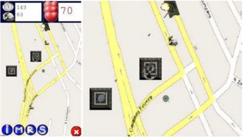
Figure 1 - Geo Wars look and feel
Figure 1 depi ts a ta k follo i g a oad i o de to get lose to the pla e ’s lo atio hile
fi i g a k at a to e . The pla e ’s lo atio , a ked a g ee o pass i the e t e of the s ee sho s the eal lo atio of the pla e ’s positio i the ga e. Also s attered around
the ap’s st eets a e ags of o e that the pla e a o a ot pi k o i g o e the i o de to olle t e t a o e . The o e head GUI depi ts the pla e ’s u e t health,
money and match time left. On the bottom of the screen lies a succession of buttons that
7 the pause/main menu button, a feature much needed in a game that requires the tiresome
task of making the player move around the real world.
Also implemented was the usage of real time local weather that influences the game, as
good eathe oosts the pla e ’s to e s as ell as its e e ies, hile ad, loud o ai eathe , pe alises the i adi g fo es’ speed a d eapo a ge. Additionally, as an extra, it
is also gi e to the pla e the oppo tu it of t eaki g the ga e’s setti gs, su h as a uall
inserting the address of the place of where they would like to play the game. This way, the
player can enjoy a custom tailored game experience, useful when the player is playing the
game in a place where the gaming experience might be rather poor, for an instance, when
camping or travelling. Also, the player may wish to disable the usage of the GPS module
altogether, allowing the player to enjoy a location-based game (although obviously not
based on his position) even in places where he would be unable to play, such as inside
uildi gs. The pla e a e e ish to oade the a ea of the ga e’s ap i o de to
better fit his gamming skills and his physical abilities, by selecting the zoom level of a map.
This affe ts ho fast the pla e ’s a ata o es, as a highe zoo le el ea s that the ga e’s s ee depi ts a s alle a ea, a d thus the pla e ’s speed i pi els is i eased. “o,
while the player moves faster, the other units move at a similar, constant pace, meaning that
the player may customize the game to meet his physical abilities. Additionally, the player
may also chose to play a longer or shorter match by introducing the number of seconds he
wishes the match to last at most. Each and every game in Geo Wars only ends when either
time runs out or the player dies. The final score for each game takes into consideration how
much money was he left with, how long did he survive, and how much life was the player
left with.
5. Methodology
For the development of the Geo Wars game and all the above mentioned components of the
game, a particular approach was used. This approach, aimed to be as general as possible, so
as to be applicable to any other location-based games that might be developed. Before the
development of the game itself or any of its core components, a brief investigation of the
location- ased ga e’s histo as o du ted. The goal of this esea h as to dete i e
8 stereotype, and the risks associated with their usage and which content is usually used as
location based content. This investigation was the basis for the creation of a general
architecture of a location-based game, a solution that aims to correct or avoid most
problems related to location based games, while being general enough to be implemented
in virtually any system, architecture or game concept. The game itself is based upon the
principles and methodologies here listed, although in some cases a more specific solution
was chosen due to the nature of the game, the underlying system, or the device itself.
However, the core principles were used. The design and implementation of the concept
follo ed a Wate fall ethodolog a ia t alled the “ashi i odel, as the p oje t’s phases
overlapped, allowing to adapt the design phase of the project as some features in some
components gave their feedback, meaning that during the development of several
components of this project, the flow of it could go back and forth [MeDeOr]. Furthermore
during the solution's testing, it was clear that some useful features were being put aside, and
so using this insight the design and architecture of the game was adapted so as to include
these features. Thanks to the flexibility provided by the Sashimi model, no phase of the
soft a e’s le of de elop e t as full o pleted efo e ad a i g to the e t phase,
allowing to move back and forth along the cycle, using the feedback each phase provided in
order to better complete the blanks in the other phases. This methodology proved to be
uite useful i a situatio he e a phase ould ’t e full o pleted due to la k of o plete
knowledge of the problem. As the developme t of the ga e’s o ept g e , so did the
requirements of what the location module of the game should do, adding to it a weather
e se i e a ess, a d a o e t ped pa si g of a ap’s st u tu e as the ga e’s featu es
required.
6.
Game’s Architecture
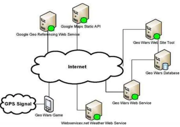
Besides the mobile application, a website, database and web service were also created.
Using the website, any user may build a customized game from scratch and share it with
other users. This way, when a player logs in he can access a list of custom-made games.
Whe fi ishi g a of these ga es, the use ’s s o e is also su itted o li e i o de to
share it with other players. All this information regarding scores, user details and predefined
9 web service, in order to assure safety. The website, however accesses this database directly.
Figure 2 - Geo Wars physical architecture
As it can be seen in the figure 2, after acquiring the GPS signal, the Geo Wars application
ac esses the I te et to o tai the Map i age of the pla e ’s o a othe gi e lo atio
using the Google Maps Static API. If the user desires to use the weather for his current
lo atio the ga e ill atte pt to use the We se i e . et’s Weathe e se i e, after
o e ti g the pla e ’s lo atio oo di ates i to its espe ti e it a d ou t o po e ts usi g Google’s Geo Refe e i g e se i e. I o de to a ess sto ed ga es a d i o de
to submit scores, the game will access the Geo Wars web service, an interface to be used for
safe and easy to use access to the Geo Wars Database. If the mobile device also possesses a
browser, the player can use this browser to access the Geo Wars web site tool so as to
create and browse through his games and scores.
7.
Game’s Development
The game was developed for Windows Mobile based devices, using both the .Net Compact
Framework 3.5 and the Direct3D Mobile API. Before the creation of the game's logic and its
10 framework, generic enough to be applicable to any location-based game concept. As such, it
was necessary to create Sprite primitives (as the game is viewed in a orthographic
perspective) and their respective picking and collision routines. Also, due to the mobile
devices lack of large amounts of available RAM, it was needed to do some instantiation of
textures in order to prevent Out Of Memory Exceptions, as each process in windows mobile
is only reserved with around 20 MBs of RAM. Furthermore, since these games usually rely
upon a lot of trigonometry, this solution also computes sines and cosines for 360 values of
angles while the user is at the main menu of the game in an attempt to cache them and to
be easily accessible when needed, thus reducing processing power needed while in the
game. The game architecture also integrates the Windows Mobile Intermediate Driver, a
solution that allows the developer to easily and readily access the GPS module in order to
read its values. The game, after receiving valid longitude-latitude NMEA data (a specification
that the Natio al Ma i e Ele t o i s Asso iatio de eloped fo data e ha ge o the use ’s
Google Maps style address, attempts to access location data based upon it. However, not
onl is the Lo atio odule of the ga e used p io to the ga e’s sta t, it is also used e e
second or so while the game is occurring in order to correctly move the player around the
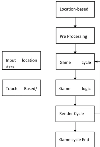
11 Figure 3 - Generic Location Based Game Flow Chart
In the schematic in figure 3 it can be seen that, while some of the needed location-based
data is loaded efo e the sta t of the ga e’s le, du i g the p e-processing phase, another
th ead, pa allel ith the ga e itself, ill o ti uall dete i e if the pla e ’s eal o ld
position has changed, and if it has, that same thread will change some of the location-based
information. At each game logic cycle this location-based information is integrated with the
ga e’s logi . Also, tou h-based events are captured in a different thread, since the user
builds towers and interacts with the interface by touching the screen. The Location module
of the game uses the Google Maps Static API to get the image that represents the location of
the given address or the GPS values. Afterward, that very same image is analyzed in order to
determine what are the parts of that map that are to be considered roads, green spaces,
water zones, buildings and other elements. This all happens just during the pre-processing
phase of a game. It is only done once per game. This way, it is possible to integrate that
i fo atio ith the ga e’s logi . It is i po ta t to ote that hile the Lo atio odule of
the ga e o l a esses a d sto es lo atio data elated i fo atio , su h as pla e ’s
position, map nodes and their respective types, among other things, it is the Game module Pre Processing
Game cycle start
Render cycle Location Based
Data
Input location data
Game cycle end Touch Based
Events
Game logic cycle
Game cycle Start
Pre Processing Location-based
data
Input location data
Touch Based/ Other Events
Render Cycle
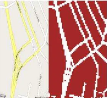
12 that accesses this information and integrates it into the game logic accordingly. The images
i figu e sho the ap that is o tai ed f o the i put B aga a, Po tugal a d hat
information is retrieved from that map. White areas represent areas that can be used by an
enemy soldier or tank to move around. Red areas are the only areas where a tower may be
placed by the player.
Figure 4 - Original game map and visual representation of the information retrieved from it
It is noticeable that the rightmost image in figure 4 depicts the information retrieved from
the other image in lower resolution. In fact, information retrieved from the map is not
obtained per pixel, but rather by first shrinking the original image and then parsing. This
allo s the ep ese tatio of the ap’s st u tu e to e si plified, so that the path fi di g
algorithm (in this case a typical A* algorithm, with 8-connectivity and usual distance based
heuristics) to use this simpler map with good results and with increased speed for an overall
acceptable precision.
8. Conclusions and Future Work
During the course of this project, it became notorious that some limitations in
location-based games were difficult if not impossible to overcome completely due to their natural
unpredictability. As such, some of the mentioned issues were not solved as much as they
13 with the feature of allowing the player to play a game that is not based on his location. This
does ’t o stitute a solutio fo the p o le ut a alte ati e to ot ei g able to play a
location-based game at all. It also became evident that balancing a location-based game is
rather difficult as some players may find the game too easy or too difficult from location to
location. Even when taking that into account it is difficult to measure how hard or how easy
the game should be based on the location related information. As such, balancing issues of
the game were, by the end of the testing phase of development, considered to be the most
difficult to solve. However, and thanks to the methodology based on the agile Sashimi
model, that allowed to adjust requirements, features and the design of the solution even as
other phases of the project went on being developed, many solutions for issues of
location-based games that were only spotted during the implementation phase of the project were
i luded i the ga e’s desig . Additio all tha ks to the eatio of a ge e al lo atio
-based game solution (the previously mentioned framework, the base upon Geo Wars was
implemented), the game’s fi al o ept as o l ela o ated a d o pleted lo g afte a
simpler and different location based game was implemented using the very same general
design, proving that the generic approach to the location-based games was possible through
the said framework.
The game Geo Wars has had a good acceptance in the mobile gaming community as it can
be seen in this xda-developers thread used for testing and gathering of feedback to be used
in subsequent iterations (http://forum.xda-developers.com/showthread.php?t=694276). So much that the framework is being ported to 3D so that Geo Wars may also be a 3D game.
Prototype versions for both 2D and 3D are also available for download in said thread as well
as a small video depicting a Geo Wars match. Many of the testers of the game asked for a
multiplayer version of the game. Alas, the framework, as of now, is incapable of allowing
such a feature, although it will most likely be altered in order to accommodate that
possibility.
9. Acknowledgments
This work is partially supported by the Portuguese government, through the National
Foundation for Science and Technology - FCT (Fundação para a Ciência e a Tecnologia) and
14
EIA/ / e titled DWikiU – D Wiki fo U a E i o e ts .
10. Bibliographical References
[MDA] Hu i ke ,Ro i , LeBla ,Ma , )u ek ,Ro e t MDA: A Fo al App oa h
to Game Design and Game Research , Challe ges i Ga e AI,
[GDE] No ak, Jea ie , Ga e De elop e t Esse tials , Del a Ce gage
Learning
[FLBS] “tei ige , “tefa , Neu , Mo itz Ed a des, Alistai Fou datio s of
Lo atio Based “e i es i Le tu e Notes o LB“ , .
[LoCo] Locomatrix, 2010. http://www.locomatrix.com/about.html , 10/2009.
[GroSp] Groundspeak 2010 http://www.groundspeak.com/ , 10/2009.
[GeoCa] GroundSpeak.Geocaching, 2010.http://www.geocaching.com/ , 10/2009.
[GPSGa] GPSgames.org.GPSGames.org, 2009 . http://www.gpsgames.org/ , 10/2009.
[MinWar] GPS Games. Minute War, 2006. http://ultimategps.com/gps_fun.html , 10/2009.
[Shutter] GPS Games. Shutterspot
http://www.gpsgames.org/index.php?option=com_wrapper&wrap=Shutterspot , 10/2009.
[PhoTag] Na igadget. Take do ou ta gets! A gps pho e tag ga e.
http://www.navigadget.com/index.php/2006/04/04/take-down-your-targets-a-gps-phone-tag-game , 10/2009
[WiGo] GroundSpeak, WhereIGo, 2008. http://www.wherigo.com/, 10/2009
[PacMan] Pac Manhattan http://www.pacmanhattan.com/about.php, 10/2009
[BotFig] Dodso , “ea Read , ai , te t , The Gua dia ,
http://www.guardian.co.uk/technology/2002/aug/15/electronicgoods.games, 5/2010
[MeDeOr] A aújo, Ma uel, Ro ue, Li í io U a p oposta etodológi a pa a
o ga iza o dese ol i e to de jogos o igi ais , VideoJogos
[MGD] Joselli, Ma k, Clua, Este a Mo ile Ga e De elop e t: A “u e o the
Technolog a d Platfo s fo Mo ile Ga e De elop e t , VideoJogos
[Sashi] Risi g, Ji “ashi i Wate fall “oft a e De elop e t P o ess , Ma aged
Mayhem,