www.nat-hazards-earth-syst-sci.net/14/1145/2014/ doi:10.5194/nhess-14-1145-2014
© Author(s) 2014. CC Attribution 3.0 License.
and Earth System
Sciences
Avalanche situation in Turkey and back calculation
of selected events
A. Aydın1, Y. Bühler2, M. Christen2, and I. Gürer3
1Düzce University Faculty of Forestry, Konuralp Campus, 81620 Düzce, Turkey
2WSL Institute for Snow and Avalanche Research SLF, Flüelastrasse 11, 7260 Davos Dorf, Switzerland
3Professor Emeritus, Gazi University Faculty of Engineering Civil Engineering Department, Maltepe 06570 Ankara, Turkey
Correspondence to:A. Aydın ([email protected])
Received: 24 December 2013 – Published in Nat. Hazards Earth Syst. Sci. Discuss.: 21 January 2014 Revised: – – Accepted: 8 April 2014 – Published: 19 May 2014
Abstract. In Turkey, an average of 24 people die in snow avalanches every year, mainly in the eastern part of Anato-lia and in the eastern Black Sea region, where high-mountain ranges are close to the sea. The proportion of people killed in buildings is very high (87 %), especially in comparison to other European countries and North America. In this paper we discuss avalanche occurrence, the climatic situation and historical avalanche events in Turkey; in addition, we identify bottlenecks and suggest solutions to tackle avalanche prob-lems. Furthermore, we have applied the numerical avalanche simulation software RAMMS (rapid mass movements sim-ulation) combined with a (digital elevation model) DEM-based potential release zone identification algorithm to an-alyze the catastrophic avalanche events in the villages of Üzengili (Bayburt province) in 1993 and Yaylaönü (Trabzon province) in 1981. The results demonstrate the value of such an approach for regions with poor avalanche databases, en-abling the calculation of different scenarios and the estima-tion of run-out distances, impact pressure and flow height.
1 Introduction
Mountain ranges can provide valuable resources such as minerals, recreational services, wood for fuel and building material, and special agricultural products (Kräuchi et al., 2000). They are also an important source of water (Viviroli et al., 2007). However, mountain environments, due to their harsh topography and climatic conditions, are subject to nat-ural hazards such as landslides, debris flows, rockfalls, flash floods and snow avalanches. Mountain areas occupy about
one-fourth of the total land surface on earth and are home to about 1/10 of all human beings (Ives et al., 1997; Price and Butt, 2000). Seventy-eight percent of Turkey’s land sur-face consists of mountains, with 33.4 million people (about 47 % of the country’s total population) living in these regions (EEA, 2010).
Turkey in general is comprised of two peninsulas, Thrace and Anatolia, with a 2-D area of 769 471 km2, excluding
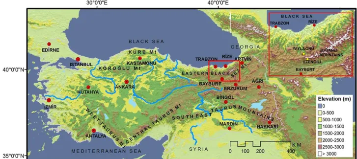
lakes (Elibüyük and Yılmaz, 2010). This present landform was created by the convergence of Tethys Sea sediments lo-cated among the African, Eurasian and Arabian plates. Thus, Alpine orogeny began with this convergence and has con-tinued up to present day (Bozkurt, 2001). Therefore, Turkey has been tectonically active, and this has directly affected the character of its landforms and determined its aspect, slope and elevation features. Mountain ranges run in a west–east direction, parallel to the Black Sea in the north and to the Mediterranean Sea in the south. Comparatively high moun-tains (e.g., the A˘grì Mountain at 5165 m and the Re¸sko summit of Cilo Mountain at 4168 m) and plains (e.g., the Do˘gu Beyazıt plateau at 2000 m and the Erzurum plateau at 1900 m) exist at the eastern part of the Anatolian peninsula (Fig. 1). According to a recent study (Elibüyük and Yılmaz, 2010), the mean altitude of Turkey is 1141 m a.s.l., more than three times higher that of Europe (300 m a.s.l.), with a mean slope angle of 10◦
. Altitudes higher than 1500 m with slopes greater than 27◦
cover 5.1 % of the total area. These values dramatically increase in the eastern Black Sea region, which has been identified as a hotspot for avalanches. The average altitude and average slope of the eastern Black Sea area are 1662 m a.s.l. and 19◦
Fig. 1.Physical map of Turkey showing the most important mountain ranges and study areas (upper right corner).
the total land surface is higher than 1500 m a.s.l. and 22.6 % of all the slopes are steeper than 27◦
(Elibüyük and Yıl-maz, 2010). Altitudes higher than 1500 m with slopes greater than 27◦
cover 12 % of the total eastern Black Sea region (ErkanYılmaz, 2012, personal communication, see Fig. 1).
Even though avalanches are a serious issue in Turkey, the management of snow avalanches has not yet attracted the necessary attention. According to a new regulation, the of-fice of mountainous areas management (MAM), organized under the Turkish Forest Service, was established in 2011. This new office is mainly responsible for the prevention of floods, snow avalanches and landslides, and for preparing hazard and risk maps. Before the establishment of this office, the avalanche team (AT) of the General Directorate of Dis-aster Affairs (GDDA) was responsible for this task. The AT was established after the destructive 1992–1993 avalanche cycle in Turkey and had undertaken various national and in-ternational projects (Gürer, 1998). Because of the recent re-organization, this team was abolished and all staff members were transferred to various other departments. This disconti-nuity has been a big drawback to setting up an institutional memory and years of accumulated experience have been lost. Due to the vagueness of the duties and responsibilities of the MAM, no avalanche events have been recorded since the AT was abolished in 2009. The MAM office is located in central Ankara and as of yet has no branch offices in local avalanche-prone areas. When avalanches occur, there is at present no one responsible for recording and documenting the events, drawing outlines or making necessary measure-ments and analyses. Therefore, only a few recorded events are available, and there is no updated avalanche database in place today in Turkey.
Snow and avalanche mitigation profits substantially from research and development (R&D) organizations such as the WSL Institute for Snow and Avalanche Research SLF in Switzerland and the National Research Institute of Science and Technology for Environment and Agriculture (IRSTEA, formerly CEMAGREF) in France. Continuity in research, determining the needs and gaps in research and practice, and increasing the quality of practical measures are some of the main aims of such institutions. In Turkey there are no such research institutes, resulting in a lack of support for practitioners and capacity building in the country.
Even though the MAM is responsible for the hazard and risk mapping of natural hazards in Turkey, no guidelines or regulations exist to define the process of hazard and risk map-ping; therefore, there are no restrictions on land use. As a result, buildings, tourism facilities and traffic infrastructures are still being constructed in high-risk avalanche zones in Turkey.
In Turkey weather stations are operated by the State Me-teorological Office (SMO). Almost all stations are located in city centers, which do not represent the high-mountain ranges or places far from the cities where the avalanches oc-cur. Furthermore, the total amount of snow and rainfall pre-cipitation as measured by the gauges is not differentiated. The quality and scarcity of this meteorological data make them nearly meritless for analyzing avalanche events.
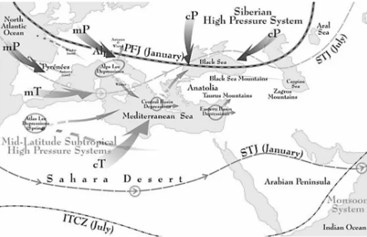
Fig. 2.Air masses affecting Turkey (Akçar and Schlüchter, 2005).
2 Climatic situation
In winter, Turkey is usually under the influence of polar air masses, classified as maritime polar (mP) and continental po-lar (cP). Maritime popo-lar air masses originate in the Atlantic Ocean and pass over Europe from NW to SE (Fig. 2). They bring rainfall to the Black Sea coast and snow to the inland region. Continental polar air masses originate in Siberia and are very cold and dry. When they pass over the Black Sea, they become moister and can cause orographic rainfall in the Black Sea coastal zone. When cP air masses reach the Mediterranean region, they get warmer and gain moisture, resulting in thunderstorms. The Mediterranean and Black Sea mountain ranges run parallel to the coasts. This topogra-phy causes significant differences in climate from one region to another. While coastal areas have a milder climate, the high-mountain hinterlands of the coasts receive high amounts (2–3 m) of snowfall (Gürer and Naaim, 1993), and the inland Anatolian plateau experiences cold winters with limited pre-cipitation, for example, 443 mm in Bayburt and 407.5 mm in Erzurum (Sensoy, 2004; Akçar and Schlüchter, 2005; Bek-ereci et al., 2010). The orographic effects in both the Tau-rus and Black Sea mountains are dominant. For instance, in the eastern Black Sea region rainfall sharply decreases from coastal Rize, with a mean annual precipitation of 2200 mm, to the inland eastern Anatolian city of Erzurum, 130 km to the south, with mean annual precipitation of 407.5 mm. Both cities are situated north of the Mediterranean climate bound-ary (Akçar and Schlüchter, 2005).
3 Avalanche history
Historically, avalanches have occurred mainly in the eastern Black Sea region, in eastern Anatolia, in the mountainous part of the south-eastern region of Anatolia, and, last but not least, in high and/or steep-sloped mountainous areas in the rest of the country (Fig. 3). Avalanche fatalities are high in Turkey, with an average of 24 lives lost per year. Between
Fig. 3. Avalanche record map of Turkey (yellow color refers avalanche observed cities and red stars refer to recorded avalanche locations, Source: GDDA).
ulation model of RAMMS. Thus, the 1993 Üzengili (Bay-burt province) avalanche, documented in several publications (Gürer and Naaim, 1993; Gürer et al., 1993), and the 1981 Yaylaönü (Trabzon province) avalanche, where data was col-lected in the field and affected people interviewed by two of the authors, were selected for this study. Furthermore, these cases are located in the Bayburt–Rize–Trabzon triangle, a site accounting for one-third of all recorded avalanches in Turkey.
4 Study area
This study was conducted in two different survey areas (Üzengili and Yaylaönü) in order to back calculate the ob-served and documented avalanche events. Üzengili village is located at 40◦23′00′′E–40◦29′30′′N and is 41 km north
of the Bayburt city center (Fig. 1). The village is located in the lee direction of the So˘ganlì Mountains in the east-ern Black Sea region of Turkey. The altitude of the vil-lage is 1950 m a.s.l. and it is in a downstream area of bowl-shaped slopes. Yaylaönü village is located at 40◦
18′
00′′
E– 40◦
35′
15′′
N and 105 km south-east of the Trabzon city cen-ter (Fig. 1). The village is located in the northern part of the So˘ganlì Mountains in the eastern Black Sea region of Turkey at an altitude of 1700–1900 m a.s.l., at the edge of the central section of an avalanche track.
For this study, we generated DEM data sets from 10 m contour interval and 1:25 000 scaled topographical maps. We generated raster data of the study area with a grid res-olution of 10 m as input for the numerical simulations with RAMMS. Reference information on the events was obtained by interviewing affected people and, consulting photographs, newspaper articles and archives of official institutions.
4.1 The 1993 Üzengili avalanche
The Üzengili avalanche path consists of an open bowl in the upper part, a channeled track and an open run-out zone with slopes of 7◦
–10◦
(Fig. 6). Both, the release and the run-out zones were sparsely vegetated with small bushes. The 1993 avalanche stopped about 500 m before the bottom of the val-ley. A brief description of the Üzengili avalanche and in-formation on deposition height (at the center of the debris about 8–10 m) can be found in Gürer and Naaim (1993). A sketch (Fig. 9) by the GDDA describing the location of dam-aged buildings and mosque were given and it is assumed
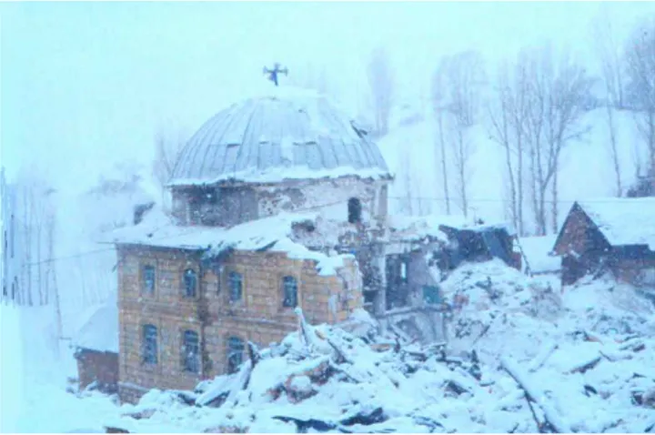
Fig. 4.Destroyed mosque due to 1993 avalanche event in Üzengili village.
that this sketch shows the boundary of the avalanche. In-formation on building damage and a collection of observa-tions from local people were taken from GDDA archives. All residential structures had been constructed from bricks and wooden material. Only mosque had been constructed of masonry. Release depth estimation was done based on Gürer and Naaim (1993) and statements from villagers and finally we use 160 cm for the model.
The avalanche mass started from the high part of the mountain on 18 January 1993 at 7:30 a.m. and buried 85 houses, 72 of which were completely destroyed or trans-ported to the far end of the run-out zone (Fig. 4). Fifty-nine people were killed and 21 injured. Prior to the avalanche release, new snow had fallen continuously for a period of three days, with heavy northern winds which brought 70 cm of fresh and dry snow; the air temperature had consistently remained at well-below zero (Gürer and Naaim, 1993). The villagers inferred that the first avalanche had come from the slope on the orographic left-hand side (the release zone of this avalanche is visible for the villager), filling the chan-nel with snow deposits. Just a few minutes later, a second avalanche came from the slope on the right-hand side (this release zone is invisible for the villager) and flowed over the previously filled channel, destroying large parts of the vil-lage. People mentioned a past avalanche which had occurred around 1890, in which 10 houses disappeared. Other than this information, no one living there could remember any other avalanches.
4.2 The 1981 Yaylaönü avalanche
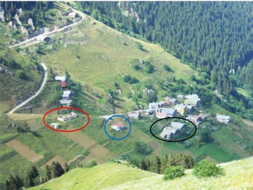
Fig. 5.Damaged school building (red ellipse) and houses (black ellipse) due to the 1981 avalanche; house indicated in blue circle constructed in 2004.
and wooden material) and the roof of the village’s school building (constructed of bricks) (Fig. 5). A bowl-shaped re-lease area, a channeled track and a run-out zone with slope angles of 8◦
–11◦
, characterize the Yaylaönü avalanche path. All release zones were covered by grass vegetation with no bushes or large trees. The 1981 avalanche stopped around 2000 m after releasing, with a 6–7 m deposition height. There is no written information documenting this event.
5 Numerical avalanche simulation software RAMMS
The numerical avalanche dynamics simulation software RAMMS was developed at the WSL Institute for Snow and Avalanche Research SLF as a tool for engineers to cal-culate two-dimensional run out distances, flow velocities, flow heights, impact pressures, and flow paths of large-scale snow avalanches. It is a further development of the one-dimensional avalanche simulation tool AVAL-1D (Christen et al., 2002). The simulations are based on the Voellmy– Salm friction model containing two parameters: the Coulomb friction (µ) and the velocity squared dependent turbulent
friction (ξ) (Voellmy, 1955; Salm et al., 1990). The model,
calibrated with real-scale avalanche measurements from the Swiss SLF test site Vallée de la Sionne, requires high-quality DEM (Bühler et al., 2011, 2012) as well as defined release areas and release depths. It solves the depth-averaged equa-tions governing avalanche flow with accurate second-order numerical schemes (Christen et al., 2010a). When used by experienced hazard experts combined with information on past avalanche events and field observations, RAMMS en-ables the calculation of different hazard scenarios as well as the back calculation of specific events (Bartelt et al., 2012; Christen et al., 2010b; Bühler et al., 2009). The software
is commercially available and is used by avalanche experts and engineering offices to plan hazard mitigation projects around the world. Currently, a module for snow avalanche and one for debris flow simulations are available; modules for shallow landslides and rock falls are under development (http://ramms.slf.ch).
6 DEM-based release zone identification
Release zones for the Üzengili case were determined using a (geographical information systems) GIS-based digital eleva-tion model DEM analysis. No snowpack or meteorological parameters are included in this analysis. Slope, planar curva-ture, roughness and size are the main parameters which are derived from the DEM in this procedure (Bühler et al., 2013). It is a further expansion of the algorithm developed by Mag-gioni and Gruber (2003) and works with high-spatial resolu-tion DEM data sets (10 m resoluresolu-tion and better). In this study, a DEM resolution of 10 m, a slope range of 28–60◦a
curva-ture threshold of 3 and a ruggedness threshold of 0.03 were used. After a final plausibility check by an avalanche expert and a correction procedure, the release zones were used as in-put for the numerical simulation software RAMMS. Such an approach has the potential to be used for large-scale hazard mapping (Gruber and Bartelt, 2007).
We identified 10 potential release zones in the first step using the DEM-based algorithm, see Fig. 6. In the second step, we checked the release zones manually and selected and corrected the polygons, based on expert knowledge. Strong winds from the north and 70 cm of freshly fallen snow (over 10–20 cm of old snow) had been observed by the villagers just before the event. The release zones were located sig-nificantly higher than the Üzengili village. Therefore, based on the Swiss guidelines (Salm et al., 1990), we used a snow depth of 160 cm and included 50 cm of wind accumulation to calculate the release depths.
For the Yaylaönü event all information was collected in the field by interviewing villagers and observers. During the avalanche, strong winds from the south and more than 24 h of continuous snowfall (90–100 cm) were reported. Three main release zones were identified. Based on this information, the release depth was estimated to be around 160 cm (Fig. 7).
7 Results and discussion
7.1 Applied scenarios
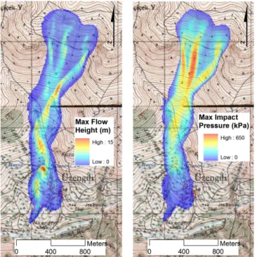
Fig. 6.Identified release zones by DEM-based release zone genera-tion approach (left); corrected release zones to use in simulagenera-tions at Üzengili (right) with a DEM resample of 10 m, a curvature thresh-old of 3 and a roughness threshthresh-old of 0.03.
Fig. 7.Outlines of the 1981 avalanche event and potential release zones (damaged school indicated in blue circle, see Fig. 5).
statements with numerical avalanche simulations, we used six different elaborated scenarios (Table 1). RAMMS allows DEM modifications, for example, updating the track with a previous avalanche deposit. For scenarios 2–6, we made the DEM adaptation after releasing zone number 1. Then we re-leased the other zones over the adapted DEM to see the ef-fect of filling the track by the first avalanche. We applied six different probable scenarios, but only scenario 3 was able to cause an event as big as had been observed; the results of scenario 3 are presented in the following sections.
At the Yaylaönü site, the avalanche occurred at 09.00 LT, so the eyewitnesses were clearly able to identify the release zone. The 1981 avalanche originated from release zone num-ber 1, see Fig. 7. Release zone numnum-ber 1 was leeward of the strong south–north winds and the snow had accumulated heavily. Release zones number 2 and 3 were located at the windward side and the wind caused the snow to drift from there to behind the northern ridge. Thus, only the avalanche release zone number 1 scenario was applied; the results are reported in the following sections.
S6 1 8–10 DEM adaptation procedures applied
7.2 Friction parameters
In RAMMS friction parameters can be specified as constant (for the whole calculation domain) or variable. Constant val-ues are recommended for a first attempt to quickly analyze the problem (Christen et al., 2010b). Variable friction pa-rameters for the entire calculation domain are automatically calculated using GIS-based terrain analysis for different re-turn periods and avalanche volume classes (RAMMS Man-ual, 2010).
In RAMMS, the dry coulomb friction (µ) and the velocity dependent turbulent friction (ξ) depend on the avalanche vol-ume, the return period and the terrain. We used values based on the calibration with avalanche events within the SLF real-scale test site Vallée de la Sionne, in Switzerland. Because both events can be considered as extreme and the volumes have been large (>60 000 m3)we have chosen
correspond-ing friction values. The aim of this study was not to calibrate the friction parameters for Turkish avalanches. Thus, for both study areas constant values ofµandξ were used for the
en-tire calculation domain. For the Üzengili avalanche siteµ= 0.19 and ξ =2100 ms−2 were selected. Because we had a channeled avalanche track at the Yaylaönü avalanche site, the parameters were selected asµ=0.24 andξ=1500 ms−2, as suggested in the Swiss guidelines (Salm et al., 1990). The Swiss guidelines were developed for the analytical Voellmy– Salm model. These values were adapted for numerical sim-ulation with AVAL-1D (Christen et al. 2002) and RAMMS. These adaptations are based on the back calculation of nu-merous large-scale avalanches in a dissertation at SLF (Gru-ber et al., 1998; Gru(Gru-ber, 1998, Gru(Gru-ber and Bartelt, 2007). The adaptedµandξ values are listed in Bartelt et al. (2010). 7.3 Flow heights and impact pressures
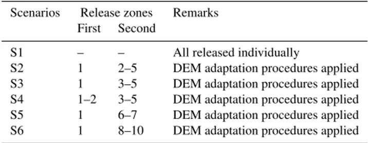
Fig. 8.Maximum flow height (left) and maximum impact pressure (right).
deposition zone, even no deposition observed a little bit of deposition simulated (Fig. 8). A sketch (Fig. 9) by the GDDA describing the location of damaged buildings by the avalanche is included and it is assumed that this sketch shows the boundary of the avalanche. Since no detailed information on flow velocity or impact pressure was available, the sim-ulation result could not be verified. However, a pressure of 10–20 kPa has been estimated at the mosque by visual in-terpretation on photographs which shows structural damages (Fig. 4), and corresponds well with the simulated avalanche results (M. Schaer, personal communication, 2012). Flow height and impact pressure for the entire avalanche track are given in Fig. 8. Furthermore, the impact pressure forces cal-culated at the mosque location are shown in Fig. 10.
Yaylaönü avalanche site: at the Yaylaönü avalanche site, the villagers’ statements about a deposition height of 6–7 m seemed to be realistic. Due to a narrow, channeled run-out zone, simulation results also showed deposition to be around 7 m at the deposition zone, which complies with the vil-lagers’ statements (Fig. 11). In 1981 the avalanche damaged the school building by breaking doors and windows and up-lifting the roof, but it was not completely destroyed. Maybe the damages at the building were caused by a powder cloud. A pressure of less than 1–2 kPa on the dense part of the avalanche could have been seen at the edge of the school building and seems to be acceptable. The simulation results support this argument. A sketch based on villagers’ state-ments drawing the outline of the 1981 avalanche (Fig. 7) cor-responds to the outline of the modeled avalanche (compare
Fig. 9. Avalanche affected houses (red); non-affected houses (green); mosque indicated by blue circle, see Fig. 4 (Source: GDDA).
Fig. 7 and Fig. 11). Impact pressure for the entire avalanche track are given in Fig. 11; impact pressure forces calculated at the damaged school location are shown in Fig. 12.
8 Conclusions
Turkey is a fast developing country, with more than 78 % of its territory in mountainous areas. According to informa-tion from the Ministry of Transportainforma-tion, 15 700 km of new double-lane highways have been constructed over the last ten years and there are plans to build another 15 000 km of new railway lines by the year 2023. Furthermore, winter sport ac-tivities have been increasing in Turkey during the last decade. It can be inferred that the importance of avalanches as a ma-jor natural hazard in Turkey will increase substantially.
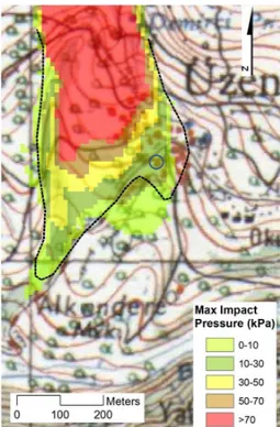
Fig. 10. Avalanche impact pressure at damaged mosque area (mosque indicated with blue circle, see Fig. 4; dashed black line indicates the outline of observed avalanche).
Avalanche mitigation requires a multidisciplinary ap-proach. Thus in Turkey, a multidisciplinary organizational structure which includes foresters, GIS experts, civil engi-neers and geographers at the central and local offices of avalanche-prone areas are needed to improve the situation. Legislation gaps must be filled in order to outline a con-crete definition of organizational duties and responsibilities. Avalanche mitigation needs the support of a strong R&D de-partment. Unfortunately, in Turkey not many scientists or researchers are involved in avalanche studies. Establishing an independent research institute would ensure success in meeting the needs of operational branches and in the train-ing of research staff. Furthermore, it is necessary to obtain sufficient meteorological data reflecting high-mountain con-ditions. This could be achieved by setting up an organized alpine weather station network.
The Üzengili (Bayburt) and Yaylaönü (Trabzon) avalanches were selected to test the feasibility of using RAMMS in such cases. Even without meteorological data and the lack of exact release area information of the Üzengili avalanche, RAMMS produced realistic results. The DEM-based release generation is a big help but requires expert knowledge; using the generated release zones directly as input of RAMMS can be deceptive and cause unrealistic results.
Fig. 11.Simulation result of Yaylaönü project area: maximum flow height (top) and maximum impact pressure (bottom).
Fig. 12.Damaged school during 1981 avalanche; impact pressure forces of around 1–2 kPa.
orig-inated from event documentation and so on (Jamieson et al., 2008).
Although villagers in Üzengili claimed that the second avalanche had come from the right-hand side slope (in flow direction), simulation results did not agree with this state-ment. We concluded that the second avalanche originated from release zones number 3–5 of the left-hand side slope (see Fig. 6 and Table 1).
This study shows that based on the observations and estimations made in this paper, we assume that RAMMS can be help for hazard mitigation planning. The impact forces predicted by RAMMS at the mosque (Üzengili avalanche) and the school location (Yaylaönü avalanche) are in good agreement with the observed situation. Although generalization is not recommended, using RAMMS with expert knowledge for sparsely documented events can yield valuable information. Many countries with alpine regions exist, where no or very sparse historic avalanche information exists; as a result, it is interesting to read how the tools developed elsewhere can be applied and what limitations and problems occur. Furthermore, hazard mapping in remote regions is a demanding task. However, to do nothing is not an option in many regions. The application of numerical simulations can therefore be a big help by keeping in mind their limitations, necessity of good event documentation and expert opinions. This papers show how such a tool can be applied.
Edited by: R. Lasaponara
Reviewed by: two anonymous referees
References
Akçar, N. and Schlüchter, C.: Paleoglaciation in Anatolia: a schematic review and first results, Eiszeitalter und Gegenwart, 55, 102–121, 2005.
Atkins, D.: Ten years of avalanche deaths in the USA, 1999/2000 to 2008/2009, International Snow Science Workshop 2010, Pro-ceedings, Lake Tahoe, CA, 768–775, 2010.
Bartelt, P., Bühler, Y., Christen, M., Deubelbeiss, Y., Graf, C., and McArdell, B.:
RAMMS User Manual: Avalanche, SLF, Davos, http://ramms. slf.ch, 2010.
Bartelt, P., Bühler, Y., Buser, O., Christen, M., and Meier, L.: Mod-eling mass-dependent flow regime transitions to predict the stop-ping and depositional behavior of snow avalanches, J. Geophys. Res.-Earth Surf., 117, 1–28, 2012.
Bekereci, A., Küçük, Ö., and Çamalan, G.: The Föhn Effects in For-est Fires of Air Masses Affecting Turkey. 1st Meteorology Sym-posium, 27-28 May Ankara, Presentations Book, 83–95, 2010 (in Turkish).
Bozkurt, E.: Neotectonics of Turkey – A Synthesis, Geodinamica Acta, 14, 3–30, 2001.
Bühler, Y., Hüni, A., Christen, M., Meister, R., and Kellenberger, T.: Automated detection and mapping of avalanche deposits using airborne optical remote sensing data, Cold Reg. Sci. Technol., 57, 99–106, 2009.
Bühler, Y., Christen, M., Kowalski, J., and Bartelt, P.: Sensitivity of snow avalanche simulations to digital elevation model quality and resolution, Ann. Glaciol., 52, 72–80, 2011.
Bühler, Y., Marty, M., and Ginzler, C.: High Resolution DEM Gen-eration in High-Alpine Terrain Using Airborne Remote Sensing Techniques, Transaction in GIS, 26, 635–647, 2012.
Bühler, Y., Kumar, S., Veitinger, J., Christen, M., Stoffel, A., and Snehmani: Automated identification of potential snow avalanche release areas based on digital elevation models, Nat. Hazards Earth Syst. Sci., 13, 1321–1335, doi:10.5194/nhess-13-1321-2013, 2013.
Christen, M., Bartelt, P., and Gruber, U.: AVAL-1D: An Avalanche Dynamics Program for the Practice, INTERPRAEVENT 2002 in the Pacific Rim, 2, 715–725, 2002.
Christen, M., Kowalski, J., and Bartelt, P.: RAMMS: Numerical simulation of dense snow avalanches in three-dimensional ter-rain, Cold Reg. Sci. Technol., 63, 1–14, 2010a.
Christen, M., Bartelt, P., and Kowalski, J.: Back calculation of the In den Arelen Avalanche with RAMMS: interpretation of model results, Ann. Glaciol., 51, 161–168, 2010b.
EEA (European Environment Agency): Europe’s ecological back-bone: recognizing the true value of our mountains.EEA Report No 6, Copenhagen, 2010.
Elibüyük, M. and Yılmaz, E.: Altitude steps and slope groups of Turkey in comparison with geographical regions and sub-regions, J. Geograph. Sci., 8, 27–55, 2010 (in Turkish). Gruber, U., Bartelt, P., and Haefner, H.: Avalanche hazard mapping
using numerical Voellmy fluid models, in: Proceedings of the Anniversary Conference 25 years of Snow Avalanche Research, edited by: Hestnes, E., Voss, 12–16 May 1998, Oslo, Norwegian Geotechnical Institute, 203, 117–121, 1998.
Gürer, I.: International cooperation for solving the avalanche prob-lem in Turkey, Nat. Hazards, 18, 77–85, 1998.
Gruber, U.: Der Einsatz numerischer Simulationsmethoden in der Lawinengefahrenkartierung: Möglichkeiten und Grenzen. Dis-sertation, Geographisches Institut der Universitaet Zürich, 1998. Gruber, U. and Bartelt, P.: Snow avalanche hazard modeling of large areas using shallow water numerical methods and GIS, Environ. Model. Software, 22, 1472–1481, 2007.
Gürer, I. and Naaim, M.: The Avalanche accident at Bayburt, Üzengili Located in North-Eastern Anatolia Türkiye on 18 Jan-uary 1993, 2nd Avalanche Dynamics Workshop, Innsbruck-Austria, 1993.
Gürer, I., Toprak F., and Ercan, S.: The avalanche accidents at So˘ganlì Mountain located in North-Eastern Anatolia, Türkiye on 18 January 1993, in: 5th International Conference on Natural and Man-Made Hazards, HAZARDS-93, 29 August–3 Septem-ber 1993, Quingdao, China, 1993.
Gürer, I., Tunçel, H., Yava¸s, Ö.M., Erenbilge, T., and Sayın, A.: Snow Avalanche Incidents in North-Western Anatolia, Turkey during December 1992, Nat. Hazards, 11, 1–16, 1995.
Ives, J. D., Messerli, B., and Spiess, E.: Mountains in the World: A Global Priority, Carnforth-Parthenon, 1997.
Jamieson, B., Margreth, B., and Jones, A.: Application and limi-tatitons of dynamic models for snow avalanche hazard mapping. Proceedings of the International Snow Science Workshop 2008, Telluride, Colorado, US, 730–739, 2008.
ment, IUFRO Research Series No. 5, 2000.
Salm, B., Burkard, A., and Gubler, H.: Berechnung von Fliesslaw-inen: eine Anleitung für Praktiker mit Beispielen, Mitteilung 47, Eidg. Institut für Schnee- und Lawinenforschung SLF Davos, 47, 1–37, 1990.
Schweizer, J. and Lütschg, M.: Characteristics of human-triggered avalanches, Cold Reg. Sci. Technol., 33, 147–162, 2001.
17,19 und 37), 1–25, 1955.