Adv. Geosci., 35, 145–155, 2014 www.adv-geosci.net/35/145/2014/ doi:10.5194/adgeo-35-145-2014
© Author(s) 2014. CC Attribution 3.0 License.
Advances in
Geosciences
Open Access
Mapping hazards from glacier lake outburst floods based on
modelling of process cascades at Lake 513, Carhuaz, Peru
D. Schneider1, C. Huggel1, A. Cochachin2, S. Guillén3, and J. García4 1Department of Geography, University of Zurich, Zurich, Switzerland
2Unidad de Glaciología y Recursos Hídricos, Autoridad Nacional de Agua, Huaraz, Peru 3Laboratoire de constructions hydrauliques, EPFL, Lausanne, Switzerland
4CREALP, Centre de recherche sur l’environnement alpin, Sion, Switzerland
Correspondence to:C. Huggel ([email protected])
Received: 8 February 2013 – Revised: 18 October 2013 – Accepted: 9 November 2013 – Published: 6 January 2014
Abstract. Recent warming has had enormous impacts on glaciers and high-mountain environments. Hazards have changed or new ones have emerged, including those from glacier lakes that form as glaciers retreat. The Andes of Peru have repeatedly been severely impacted by glacier lake out-burst floods in the past. An important recent event occurred in the Cordillera Blanca in 2010 when an ice avalanche im-pacted a glacier lake and triggered an outburst flood that affected the downstream communities and city of Carhuaz. In this study we evaluate how such complex cascades of mass movement processes can be simulated coupling differ-ent physically-based numerical models. We furthermore de-velop an approach that allows us to elaborate corresponding hazard maps according to existing guidelines for debris flows and based on modelling results and field work.
1 Introduction
High-mountain environments with snow and ice are particu-larly sensitive to climatic changes (Haeberli and Beniston, 1998; Lemke et al., 2007). Rapid glacier retreat with for-mation of new lakes, degradation of permafrost with desta-bilizing effects on mountain slopes and critical changes in hydrological regimes and water supply are key chal-lenges for local high-mountain communities and adjacent lowland regions (Moors et al., 2011; Voigt et al., 2011). Of special concern are cascading mass movement processes, e.g. rock or ice avalanches impacting glacier lakes and triggering glacier lake outburst floods (GLOF) with far-reaching, highly destructive power. Such cascading processes
have been observed at many sites around the world where they demonstrated their extraordinarily high hazard potential (Huggel et al., 2005; Kershaw et al., 2005; Petrakov et al., 2008; Schneider et al., 2011).
The Cordilleras in Peru (Fig. 1) are especially vulnera-ble to, and affected by, impacts from climate change (Carey, 2005; Bury et al., 2011). Local communities and cities of-ten exist directly within the reach of major hazard poof-tentials such as lake outburst floods (aluviones), mud-/debris flows (huaycos) or large rock-/ice avalanches. They have been re-peatedly and severely affected during the last decades to cen-turies and thousands of people have been killed (Plafker and Ericksen, 1978; Ames, 1998; Carey, 2005; Evans et al., 2009; Carey et al., 2012). One reason for people living in the vicin-ity of icy mountain peaks and thus in potentially hazardous zones is their strong dependence on water resources from glacier melt because of the pronounced dry season (∼May to September) in this geographic region (Baraer et al., 2012). People and institutions of the Cordilleras in Peru, and in the Cordillera Blanca in particular, have long-standing ex-perience with living and adapting to changing environmental conditions (Carey, 2005; Carey et al., 2012). As early as in the 1940s, for instance, risk reduction measures were under-taken at unstable glacier lakes (Lliboutry et al., 1977). How-ever, current changes are rapidly evolving beyond historical experience and pose increasingly large challenges to local communities and institutions (Allen et al., 2009; Haeberli et al., 2010).
Fig. 1. (a)Location of province of Ancash (gray) in Peru.(b)Overview of the Cordillera Blanca (gray) within Ancash (dashed line).(c)Detail of the Cordillera Blanca with the cities of Huaraz and Carhuaz and the Río Chucchun river catchment as the main study site (dashed line). Gray areas indicate the glaciers in the year 2003 and the triangles show peaks>6000 m a.s.l. and the corresponding names. Rectangles correspond to the extents of the sub-images and background image is a colored hillshade relief derived from ASTER GDEM2 data.
Carhuaz (Figs. 1 and 2) entered a glacier lake (Laguna 513, 4428 m a.s.l., 9◦12′50′′N, 77◦33′10′′W) which has been formed during the past few decades. The avalanche triggered a flood wave that transformed into a debris flow and impacted downstream areas as it reached the city of Carhuaz (Figs. 2 and 3) (Carey et al., 2012). Fortunately, nobody was seri-ously injured but damage to property was considerable. The rapidly changing geomorphologic and glaciological situation in the Cordillera Blanca in general, and more specifically at Hualcán mountain, can result in new critical hazard situations which need to be analyzed in more detail. Therefore, an in-tegrated hazard assessment, including a detailed study of the current hazard situation and possible future scenarios as well as measures to improve local knowledge, capacities and con-crete un-bureaucratic adaptation, are critically required.
Numerical simulations of mass movements such as avalanches and debris flows have been increasingly ap-plied over the past years (Worni et al., 2013). A number of empirical or more physically based models are avail-able and have been typically used to simulate single pro-cesses of high-mountain mass movements, including rock and ice avalanches (e.g. Schneider et al., 2010; Sosio et al., 2008), debris flows (e.g. Hürlimann et al., 2006; Huggel et al., 2008), or GLOFs (e.g. Osti and Egashira, 2008; Worni et al., 2012a). Limited experience, however, exist how to model complex coupled processes of downstream cascading mass movements, such as occurred in the case of the 2010 Lake 513 event. Here we first present results of a modelling study of this event, using a physically based mass move-ment model (RAMMS) for ice avalanche, and lake outburst flood and debris flow, and a hydrodynamic model (IBER) for the simulation of the impact wave in the lake and dam
overtopping. These models were selected because they have been thoroughly tested in many case studies and settings, and because their input data requirements and generated output allowed us to couple them for the purpose of this study. Furthermore, they are open access for scientific stud-ies. Based on the calibration and validation of the models with the 2010 event we develop different hazard scenarios for the purpose of generating a hazard map for the town of Carhuaz using results from modelling and field work.
2 Data, study area and 2010 GLOF event
For this study we used remote sensing imagery and digital elevation data: SPOT 5 multispectral images from 2006 as well as high-resolution imagery available from Google Earth dating from 2003. A digital elevation model (DEM) of 8 m resolution was derived from spring 2012 WorldView satellite images. Furthermore, field campaigns to collect bathymet-ric data from Lake 513 were undertaken in July 2007 and June 2011 (Cochachin et al., 2011). The bathymetric studies allowed to reconstruct geometry and volume of the glacier lake. Additional field work, such as GPS measurements and grain size analysis, was conducted along the lake outburst flood trajectory, from Lake 513 down to the deposits of the 2010 event in Carhuaz.
D. Schneider et al.: Mapping hazards from glacier lake outburst floods based at Lake 513, Carhuaz, Peru 147
Fig. 2.Overview of the Río Chucchun catchment above the City of Carhuaz.(a)3-D view from Google Earth,(b)SPOT satellite image from
2006 with the flow path (blue line) of the cascading mass movement processes and(c)the corresponding elevation profile.
that there has been at least a second avalanche of compara-ble size (in the order of 500 000 m3) a few hours after the first event. This could also be an explanation for the differ-ent surges of the debris flow downstream, which have been reported by residents, but there remains some uncertainty re-garding their timing and characteristics.
After crossing Glacier 513, the rock-ice avalanche hit Laguna 513 and triggered an impact wave. Field evidence showed that the wave overtopped the bedrock dam by about 5 m in height at a width of 20–25 m. Taking into account the freeboard of 19 m the height of the overtopping wave was 24 m. In 1993/1994 the level of Laguna 513 was ar-tificially and permanently lowered by the construction of drainage tunnels through the bedrock dam. The analysis of the 2010 event indicated that without the tunnel construc-tions in 1993/94, the water level of Laguna 513 would have been higher and the volume and peak discharges of the flood wave in 2010 would have been easily one magnitude larger
or more. Also a slightly larger avalanche and consequent im-pact wave at Laguna 513 might have led to a much larger volume of water spilling over the dam crest. Nevertheless, the relatively small amount of water which overtopped the dam in 2010 formed a debris flow with a complex multi-flow behavior.
For the 2010 event, five main stages have been identified (see also Fig. 4):
i. Slab failure type ice-rock avalanche from the steep flank of Nevado Huascarán running down towards Laguna 513.
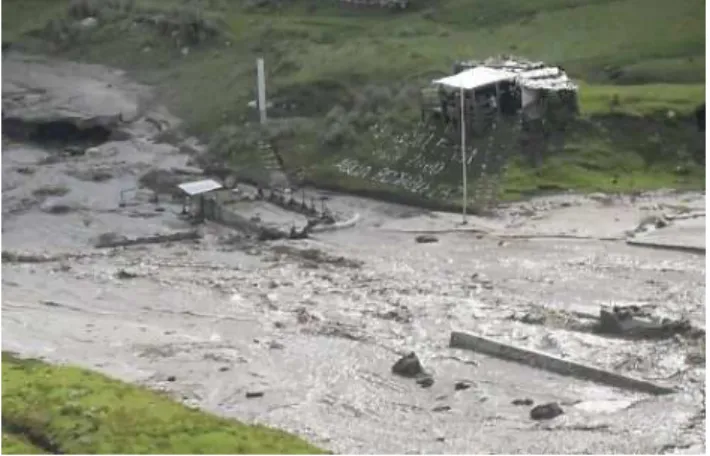
Fig. 3.Hyperconcentrated flow of 11 April 2010 at the site of the freshwater intake at Pampa Shonquil (3600 m a.s.l.). The structures have been completely inundated and partially damaged (mainly through erosion and deposition of material). Photo by Arq. Luis Meza, Carhuaz.
on the debris flow fan area above Pampa Shonquil. The GLOF in the upper Río Chucchún catchment was characterized by very high peak discharges, short total duration, high velocities and a very granular rheology consisting of a characteristic grain size in the range of 0.1–1 m (granodiorites) with a relative low concentra-tion of fines.
iv. Hyperconcentrated flow (Fig. 3) with relatively slow drainage of the water and gravel-sand-silt fraction from the debris flow deposits in the upper Pampa Shonquil and flow propagation through the flat area of the Pampa. A hyperconcentrated flow is thereby de-fined as a flow of a water-sediment mixture with a sed-iment concentration of 20–60 % by volume, while de-bris flows show higher sediment concentration of 60 % or more (Worni et al., 2012b). We identified flow types based on field evidence of flow and sediment deposi-tion, and channel geometry and characteristics. In the case of the 2010 event the flow density was increased by higher sediment concentration due to lateral erosion of the old sandy to silty lake sediments in the plain of Pampa Shonquil (Kaser and Osmaston, 2002). v. Secondary debris flow initiation below Pampa
Shon-quil by increasing flow velocity due to a steeper flow channel and further erosion of friable material. At this stage, the peak discharge was much lower than at the time of the lake outburst flood, but the duration was longer. Coarse material was finally deposited within less inclined or wider zones in the channel and on the debris flow fan of Carhuaz while finer material reached Río Santa.
The 11 April 2010 event with its five main phases was the basis for the application of the models, and their calibration,
as described in the next section. The dimension of the 2010 event also was taken into consideration for the development of the hazard scenarios.
3 Modeling the 2010 avalanche and lake outburst flood
The rock-ice avalanche of 11 April 2010 was modeled with the numerical and physically based avalanche and debris flow model “RAMMS” (Christen et al., 2010). This physically based dynamic model uses a finite-volume scheme to solve the 2-D shallow water equations. The frictional resistance in x andy direction which is acting against gravitational ac-celeration is described by using a Voellmy approach which incorporates a dry Coulomb frictionµand a turbulent fric-tionξ (Bartelt et al., 1999). RAMMS has the advantage that maximum flow depths and maximum velocities are direct outputs for each cell of the DEM used. These two parame-ters are fundamental requirements for hazard mapping (see Sect. 4). Furthermore, RAMMS can be applied both for ice-rock avalanche and debris flow processes, and accordingly disposes of the option of block release or hydrograph mass movement initiation. This is an important advantage for mod-eling the cascading processes of Lake 513.
For the initial ice-rock avalanche the originally assumed 300 000 m3of ice and rock have been iteratively adjusted to fit the observations (flow traces, estimated source area vol-ume) and to the spillover which was modeled in the next step. For the impact wave modeling in Laguna 513, the RAMMS model results have been used as input parameters. Particu-larly these have been the three parameters volume, density, and velocity of the avalanche at the time of the impact in Laguna 513. In Fig. 4 best-fits of the iterative retrospec-tive modeling that led to impact velocities of the avalanche around 40–50 m s−1on the lake surface can be seen.
Impact wave calculations were made using the method proposed by Heller et al. (2009). The input data for this method were volume, density and velocity of the mass in-coming to the lake provided by RAMMS. To simulate the wave propagation along the lake, the IBER model (IBER, 2010) was used. IBER is a hydrodynamic model for simulat-ing turbulent free surface unsteady flow and environmental processes in river hydraulics. It is based on a finite-volume non-structured mesh made up of triangle or quadrilateral el-ements. In the hydrodynamic module, the depth-averaged two-dimensional shallow water equations are solved (2-D Saint-Venant Equations) by an explicit upwind first-order scheme (Vázquez-Cendón, 1999), which performs well with irregular geometries such as high mountain topography. In addition, IBER has a friendly user interface that allows pre-processing, computation and post-processing without using additional software.
D. Schneider et al.: Mapping hazards from glacier lake outburst floods based at Lake 513, Carhuaz, Peru 149
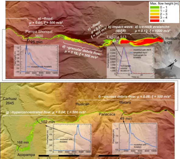
Fig. 4.Process chain of the 11 April 2010 event, modeled as follows:(a)rock-ice avalanche using RAMMS;(b)impact wave using IBER; and
(c)to(g)flood to debris flow using RAMMS. The process cascade was initiated with an estimated ice-rock avalanche volume of 450 000 m3. Parametersµandξcorrespond to the applied dry Coulomb and “turbulent”/viscous friction coefficient of the Voellmy model, respectively (Christen et al., 2010). Background: color-shaded relief of WorldView 8m-DEM.
its duration were adjusted in order to generate an initial wave similar to that calculated through Heller et al.’s (2009) method. Also, the back and forward swashing of the water as well as the spillover at the rock dam have been calibrated by the wave tracks visible in the post-event high resolution satellite image and examination during the field visit on 11 November 2011, suggesting a wave width of∼22 m and maximum height of∼5 m at the breach on the top of the dam. After the wave propagation, the results obtained by IBER (water depth, velocities and unitary discharges) were used to calculate the spillover hydrographs at the crest of the dam.
Modeling results indicate that for the estimated rock-ice avalanche density of 1000 kg m3 and the impact velocity calculated by RAMMS, a lake impact volume of at least 450 000 m3 is required to produce a wave that overtops the dam. Such a volume does still fit in the range of the estima-tions described above, but it is evident that also the density
and/or the velocity could have been higher than assumed and calculated to achieve the necessary impact momentum.
The spillover could be well represented by the IBER model simulations (Fig. 4), however, some modifications to the original assumptions were required so that the original impact volume of 300 000 m3has been augmented to 450 000
m3(see above).
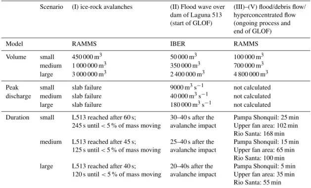
Table 1.Overview of volumes, peak discharges, and durations of the mass movement for each scenario and the applied models. Roman numbers correspond to the process stages described previously.
Scenario (I) ice-rock avalanches (II) Flood wave over (III)–(V) flood/debris flow/ dam of Laguna 513 hyperconcentrated flow (start of GLOF) (ongoing process and
end of GLOF)
Model RAMMS IBER RAMMS
Volume small 450 000 m3 50 000 m3 100 000 m3
medium 1 000 000 m3 350 000 m3 700 000 m3
large 3 000 000 m3 2 400 000 m3 4 800 000 m3
Peak small slab failure 9000 m3s−1 not calculated
discharge medium slab failure 40 000 m3s−1 not calculated large slab failure 180 000 m3s−1 not calculated
Duration small L513 reached after 60 s; 30–40 s after the Pampa Shonquil: 25 min 245 s until<5 % of mass moving avalanche impact Upper fan area: 102 min
Rio Santa: 168 min medium L513 reached after 45 s; 25–40 s after the Pampa Shonquil: 15 min
125 s until<5 % of mass moving avalanche impact Upper fan area: 65 min Rio Santa: 100 min large L513 reached after 40 s; 20–40s after the Pampa Shonquil: 5 min
120 s until<5 % of mass moving avalanche impact Upper fan area: 35 min Rio Santa: 55 min
Another result of the model is that∼200 m further down-stream (below the tunnel outlet), the peak discharge had al-ready reduced to∼5000 m3s−1. This suggests a rapid atten-uation of the wave due to a longitudinal distribution of the water.
The downstream propagation of the water wave and de-velopment of a debris flow and hyperconcentrated flow with varying flow rheologies was modeled with the RAMMS model according to Mergili et al. (2011), Scheuner et al. (2009), and Stricker (2010). The required information for the input volumes, peak discharges, and shapes of the hydro-graph were reconstructed based on field evidence and further available qualitative event descriptions, such as from Carey et al. (2012), by geometric characteristics of the event foot-print derived from post-event satellite imagery, and accord-ing to the IBER modelaccord-ing results. This strategy allowed the reconstruction of the entire process chain. The flow rheol-ogy of the GLOF was varied by applying spatially variable Voellmy friction parametersµandξ (Christen et al., 2010) depending on the estimated grain size distribution and wa-ter content. This has been completed section-wise and in a strongly simplified qualitative way (Fig. 4).
The calculated inundation areas, flow heights and travel times correspond well with the reality. However, on the flat fan area between Carhuaz and Acopampa, the inundation ap-pears somewhat exaggerated in width. Besides difficulties in determining realistic friction parameters and volumes for the model, the source of this inaccuracy could also have its origin in the DEM.
4 Hazard assessment and mapping
D. Schneider et al.: Mapping hazards from glacier lake outburst floods based at Lake 513, Carhuaz, Peru 151
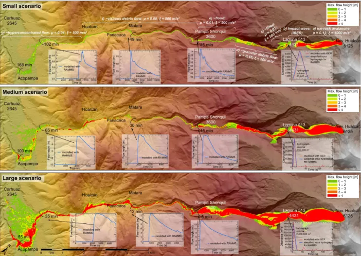
Fig. 5.Numerical modeling results (RAMMS) of three scenarios (small, medium, large) of potential mass movement process chains. The
graph showing the small scenario includes indications of frictional parameters used in the RAMMS model which is valid for all three scenarios (white font). The dimensions of the ice-rock avalanche, dam overtopping flood wave, and flood, hyperconcentrated flow and debris flow for each scenario are given in Table 1. The three discharge hydrographs near the initiation area correspond to the output hydrograph calculated by the IBER model (red dotted line) and the simplified (blue) hydrograph has been used as input hydrograph for RAMMS. The three flow height hydrographs downstream have been calculated with RAMMS for a pixel at the center of the river. Note also the flow durations which are indicated in minutes along the flow path. Background: color-shaded relief of WorldView 8m-DEM.
realistic for the specific setting with a steep hanging glacier, and compared to other comparable avalanche initiation areas around the world (Schneider et al., 2011).
The volumes and peak discharges of the flood waves over-topping the dam of Laguna 513 are calculated with the IBER model based on the ice-rock avalanche input parameters as described above. The calculated flood wave volumes (Ta-ble 1) show that the retention function of the 20 m freeboard at Laguna 513 is limited to small-scenario avalanche impacts (comparable to the 2010 event) and that larger avalanches can mobilize water volumes close to the avalanche volume. Finally, the GLOF process (stages III–V) was modeled in a way that material was eroded by a factor of 2 compared to the initial volume. This erosion factor is based on an as-sumption of 50 % debris content and could be adjusted. How-ever, compared to other GLOF events around the world and
an approximate debris content of 50 % for debris flows, this value seems to be realistic.
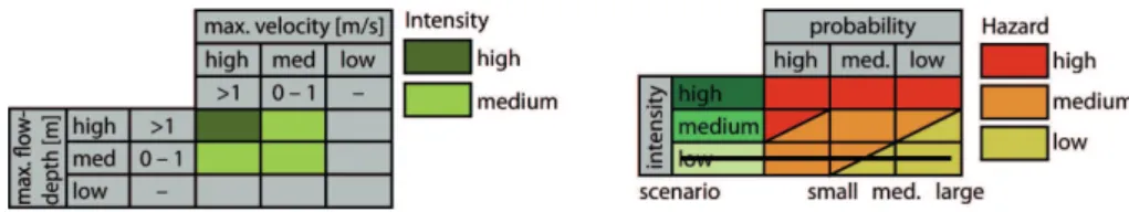
Fig. 6.Classification of debris flow intensities into two classes (left panel), and intensity-probability diagram and hazard levels (right panel) according to Raetzo et al. (2002). The low-intensity class does not exist for debris flows and is therefore marked as deleted (black line). For a better distinction of the different classes, orange is used instead of blue. See also Hürlimann et al. (2006).
The volumes increase for each flow stage due to en-trainment of sediment, but peak discharges strongly re-duce between stage (II) and (V) (hydrographs in Fig. 5). The RAMMS results also demonstrate that the modeled de-bris flows and floods (stages II to V) reach the upper fan area where deposition starts relatively fast, while the sed-imentation of material on the entire fan takes much more time. In general, the chain processes need roughly about 30/60/90 min from the initial ice-rock avalanche until the flood wave reaches the upper fan area near the city of Carhuaz for the small/medium/large scenario respectively. This time is of relevance for decision making within the alarm chain of an early warning system that is designed and implemented by several local, national and international institutions.
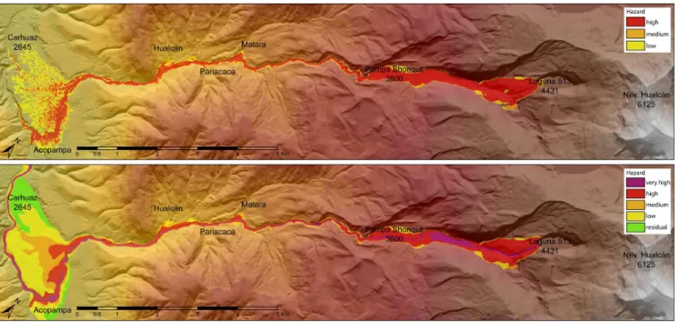
The RAMMS model is able to calculate maxi-mum flow heights and maximaxi-mum velocities of debris flow/hyperconcentrated flows for every scenario (Fig. 5). The schemes in Fig. 6 show how flow intensities are assessed as a function of flow velocity and flow height (according to guidelines by Raetzo et al., 2002). In a second step (right hand side of Fig. 6) flow intensities are converted into hazard levels. Following these schemes, we developed in this study a semi-automatic method implemented in a GIS environment that converts RAMMS-generated flow height and velocity cell-by-cell into intensities and hazard levels, similar to Hür-limann et al. (2006). According to the definition by Raetzo et al. (2002) there is no low intensity existing for debris flows. The threshold values and classification strategies by PMA_GCA (2007) and Hürlimann et al. (2006) which are slightly different from Raetzo et al. (2002) have also been applied, but the method by Raetzo et al. (2002) gave the most reliable results in this case. As indicated in Fig. 6, the intensities of each scenario (small, medium and large) are assigned to one of three hazard levels according to the intensity-probability diagram. Intensities and hazard levels were calculated and plotted separately for each scenario with given return period. The three scenario-based hazard maps were then combined into a single hazard map by choosing for each cell the highest hazard of the three previous hazard maps. The results are a sort of a raw product of a hazard map (Fig. 7, upper panel).
This raw product generated by numerical modeling served as a basis for field-based hazard mapping. Houses and
smaller structures in the terrain are typically not well rep-resented in a DEM and their effects are thus ignored by the numerical model. Hence, the modeling results need to be evaluated, verified and adapted in the field. Based on the field work, the raw product of the hazard map was general-ized. Furthermore, two additional hazard levels were added (i.e. “very high” and “residual” hazards), as compared to in-dications by Raetzo et al. (2002). Integrating additional haz-ard levels was necessary in view of an earlier hazhaz-ard map that existed for Carhuaz in order to ensure consistency in the communication with local authorities and administrative pro-cesses. The combined and generalized hazard map as the fi-nal product for the whole Chuchún catchment is shown in Fig. 7 (lower panel).
5 Conclusions
This study we included the following main components: (i) analysis of the 2010 ice-rock avalanche and lake outburst flood event at Lake 513; (ii) modelling the cascade of mass movement processes observed in 2010 using the numerical models RAMMS and IBER; (iii) definition of lake outburst flood scenarios, and corresponding modelling, considering the conceptual framework and requirements of hazard maps; and (iv) elaboration of a hazard map based on this modelling and field work.
D. Schneider et al.: Mapping hazards from glacier lake outburst floods based at Lake 513, Carhuaz, Peru 153
Fig. 7.Upper panel: raw form of hazard map derived from modeling results with RAMMS. In this map all three scenarios are included
(for each cell, the highest hazard category according to the scheme in Fig. 6 is relevant). Lower panel: final hazard map representing a combined and generalized product of the raw product and field work. Background: color-shaded relief of the 8m-WorldView-DEM used for the numerical model.
cell were converted into different hazard levels, according to widely accepted guidelines and a GIS procedure. However, modelling results need to be verified in the field, especially at critical topographic sites which may imply model errors. Generation of hazard maps based solely on numerical mod-elling without additional field work is strongly discouraged.
In terms of the practical application of the results of this study it is noteworthy that the authorities of the city of Carhuaz recognize the hazard map produced in the frame-work of this study, and are using it among other for definition of evacuation routes in case of emergencies.
In terms of research we can state that modelling of com-plex cascades of mass movement processes is only at the beginning. This study shows that based on relatively well documented events coupling of physically based models is feasible and allows a realistic reproduction of correspond-ing events. More research, however, is needed to systemati-cally investigate the influence of scenario definition, choice of model type and parameters on final inundation heights, flow velocities and other hazard parameters. Furthermore, al-though highly relevant for natural hazard practice as numer-ical mass movement models are increasingly applied now, there is little scientific guidance and reference how to struc-ture the application of numerical models for the purpose of translating model results into hazard maps. This study can make a contribution in this respect but further documented cases would be desirable.
Acknowledgements. This study has been conducted within a Peruvian-Swiss climate change adaptation and risk reduction project (“Proyecto Glaciares”), funded by the Swiss Agency for Development and Cooperation (SDC). The project involves, and supports, collaboration between several Peruvian and Swiss scientific and technical institutions. We acknowledge the col-laboration with CARE Peru, and especially with David Ocaña, Cesar González, Karen Price, and Lucas Torres and other col-leagues at the Unidad de Glaciología y Recursos Hídricos, Autoridad Nacional de Agua, Huaraz. We also thank the following persons for various discussions and input: Cesar Portocarrero, Wilfried Haeberli, Claudia Giráldez, Yvonne Schaub, Holger Frey, Nadine Salzmann, Mario Rohrer, Toni Schleiss, and Jan Klimes. We furthermore acknowledge discussions on, and support of, the RAMMS model by colleagues from the WSL Institute for Snow and Avalanche Research (SLF, Marc Christen, Yves Bühler) and Brian McArdell (WSL). Finally, we greatly appreciate the com-ments made by Raphael Worni and another anonymous reviewer.
Edited by: K. Tokeshi
References
Allen, S. K., Schneider, D., and Owens, I. F.: First approaches to-wards modelling glacial hazards in the Mount Cook region of New Zealand’s Southern Alps, Nat. Hazards Earth Syst. Sci., 9, 481–499, doi:10.5194/nhess-9-481-2009, 2009.
Ames, A.: A documentation of glacier tongue variations and lake development in the Cordillera Blanca, Peru, Z. Gletscherk. Glazialgeol., 34, 1–26, 1998.
Baraer, M., Mark, B. G., McKenzie, J. M., Condom, T., Bury, J., Huh, K.-I., Portocarrero, C., Gómez, J., and Rathay, S.: Glacier recession and water resources in Peru’s Cordillera Blanca, J. Glaciol., 58, 134–150, 2012.
Bartelt, P., Salm, B., and Gruber, U.: Calculating dense snow avalanche runout using a Voellmy-fluid model with ac-tive/passive longitudinal straining, J. Glaciol., 45, 242–254, 1999.
Bury, J. T., Mark, B. G., McKenzie, J. M., French, A., Baraer, M., Huh, K. I., Zapata Luyo, M. A., and Gómez López, R. J.: Glacier recession and human vulnerability in the Yanamarey watershed of the cordillera Blanca, Peru, Climatic Change, 105, 179–206, 2011.
Carey, M.: Living and dying with glaciers: people’s historical vul-nerability to avalanches and outburst floods in Peru, Global Planet. Change, 47, 122–134, 2005.
Carey, M., Huggel, C., Bury, J., Portocarrero, C., and Haeberli, W.: An integrated socio-environmental framework for climate change adaptation and glacier hazard management: Lessons from Lake 513, Cordillera Blanca, Peru, Climatic Change, 112, 733– 767, 2012.
Christen, M., Kowalski, J., and Bartelt, P.: RAMMS: numerical sim-ulation of dense snow avalanches in three-dimensional terrain, Cold Reg. Sci. Technol., 63, 1–14, 2010.
Cochachin, A.: Batimetría de la Laguna 513, Estudio y monitoreo de las lagunas altoandinas., Unidad de Glaciología y Recursos Hídricos, Autoridad Nacional del Perú, Huaraz, Peru, 2011. Evans, S. G., Bishop, N. F., Smoll, L. F., Murillo, P. V., Delaney,
K. B., and Oliver-Smith, A.: A re-examination of the mecha-nism and human impact of catastrophic mass flows originating on Nevado Huascarán, Cordillera Blanca, Peru in 1962 and 1970, Eng. Geol., 108, 96–118, doi:10.1016/j.enggeo.2009.06.020, 2009.
Haeberli, W. and Beniston, M.: Climate change and its impacts on glaciers and permafrost in the Alps, Ambio, 27, 258–265, 1998. Haeberli, W., Clague, J. J., Huggel, C., and Kääb, A.: Hazards from lakes in high-mountain glacier and permafrost regions: climate change effects and process interactions, in Avances de la geomor-fología en España 2008–2010, Proceedings XI Reunión Nacional de Geomorfología, Solsana, Spain., 2010.
Heller, V., Hager, W. H., and Minor, H.-E.: Landslide generated im-pulse waves in reservoirs – basics and computation, in: Mitteilun-gen, 211, edited by: Boes, R., ETH Zurich, Versuchsanstalt für Wasserbau, Hydrologie und Glaziologie (VAW), Zurich, 2009. Huggel, C., Zgraggen-Oswald, S., Haeberli, W., Kääb, A., Polkvoj,
A., Galushkin, I., and Evans, S. G.: The 2002 rock/ice avalanche at Kolka/Karmadon, Russian Caucasus: assessment of extraordi-nary avalanche formation and mobility, and application of Quick-Bird satellite imagery, Nat. Hazards Earth Syst. Sci., 5, 173–187, doi:10.5194/nhess-5-173-2005, 2005.
Huggel, C., Schneider, D., Miranda, P. J., Delgado Granados, H., and Kääb, A.: Evaluation of ASTER and SRTM DEM data for lahar modeling: A case study on lahars from Popocatépetl Vol-cano, Mexico, J. Volcanol. Geoth. Res., 170, 99–110, 2008. Hürlimann, M., Copons, R., and Altimir, J.: Detailed debris flow
hazard assessment in Andorra: a multidisciplinary approach, Ge-omorphology, 78, 359–372, 2006.
IBER: Two-dimensional modeling of free surface shallow water flow, Hydraulic reference manual, IBER v1.0., available at: http: //www.iberaula.es/web/index.php (last access: December 2013), 2010.
Kaser, G. and Osmaston, H.: Tropical glaciers, Cambridge Univer-sity Press, Cambridge, 2002.
Kershaw, J. A., Clague, J. J., and Evans, S. G.: Geomorphic and sedimentological signature of a two-phase outburst flood from moraine-dammed Queen Bess Lake, British Columbia, Canada, Earth Surf. Proc. Land., 30, 1–25, 2005.
Lemke, P., Ren, J., Alley, R. B., Allison, I., Carrasco, J., Flato, G., Fujii, Y., Kaser, G., Mote, P., Thomas, R. H., and Zhang, T.: Observations: Changes in Snow, Ice and Frozen Ground, in Climate Change 2007: The Physical Science Basis, Contribution of Working Group I to the Fourth Assessment Report of the In-tergovernmental Panel on Climate Change, edited by: Solomon, S., Qin, D., Manning, M., Chen, Z., Marquis, M., Averyt, K. B., Tignor, M., and Miller, H. L., Cambridge University Press, Cam-bridge, UK and New York, NY, USA, 337–383, 2007.
Lliboutry, L., Morales Arnao, B., Pautre, A., and Schneider, B.: Glaciological problems set by the control of dangerous lakes in Cordillera Blanca, Peru, J. Glaciol., 18, 239–290, 1977. Mergili, M., Schneider, D., Worni, R., and Schneider, J. F.: Glacial
lake outburst floods in the Pamir of Tajikistan: challenges in prediction and modeling, in: 5th International Conference on Debris-Flow Hazards Mitigation: Mechanics, Prediction and As-sessment, 14–17 June, University of Padua, Italy, 973–982, 2011. Moors, E. J., Groot, A., Biemans, H., van Scheltinga, C. T., Siderius, C., Stoffel, M., Huggel, C., Wiltshire, A., Mathison, C., Ri-dley, J., Jacob, D., Kumar, P., Bhadwal, S., Gosain, A., and Collins, D. N.: Adaptation to changing water resources in the Ganges basin, northern India, Environ. Sci. Policy, 14, 758–769, doi:16/j.envsci.2011.03.005, 2011.
Osti, R. and Egashira, S.: Hydrodynamic characteristics of the Tam Pokhari glacial lake outburst flood in the Mt. Everest region, Nepal, Hydrol. Process., 23, 2943–2955, 2009.
Petrakov, D. A., Chernomorets, S. S., Evans, S. G., and Tu-tubalina, O. V.: Catastrophic glacial multi-phase mass move-ments: a special type of glacial hazard, Adv. Geosci., 14, 211-218, doi:10.5194/adgeo-14-211-2008, 2008.
Plafker, G. and Ericksen, G. E.: Nevados huascarán avalanches, Peru, Rockslides Avalanches, 1, 277–314, 1978.
PMA_GCA – Proyecto Multinacional Andino: Geociencias para las Comunidades Andinas: Movimientos en masa en la región and-ina: una guía para la evaluación de amenazas, Servicio Nacional de Geología y Minería, Publicación Geológica Multinacional, 4, Proyecto Multinacional Andino, Geociencias para las Comu-nidades Andinas, Canada, 2007.
D. Schneider et al.: Mapping hazards from glacier lake outburst floods based at Lake 513, Carhuaz, Peru 155
Scheuner, T., Keusen, H. R., McArdell, B. W., and Huggel, C.: Murgangmodellierung mit dynamisch-physikalischem und GIS-basiertem Fliessmodell, Wasser Energie Luft, 101, 15–21, 2009. Schneider, D., Bartelt, P., Caplan-Auerbach, J., Christen, M., Huggel, C., and McArdell, B.: Insights into rock-ice avalanche dynamics by combined analysis of seismic recordings and a numerical avalanche model, J. Geophys. Res., 115, F04026, doi:10.1029/2010JF001734, 2010.
Schneider, D., Huggel, C., Haeberli, W., and Kaitna, R.: Unraveling driving factors for large rock–ice avalanche mobility, Earth Surf. Proc. Land., 36, 1948–1966, doi:10.1002/esp.2218, 2011. Sosio, R., Crosta, G. B., and Hungr, O.: Complete dynamic
model-ing calibration for the Thurwieser rock avalanche (Italian Central Alps), Eng. Geol., 100, 11–26, 2008.
Stricker, B.: Murgänge im Torrente Riascio (TI): Ereignisanal-yse, Auslösungsfaktoren und Simulation von Ereignissen mit RAMMS, Masterarbeit, Geographisches Institut, Universität Zürich, Zürich, 2010.
Valderrama, P. and Vilca, O.: Dinamica del aluvión de la La-guna 513, Cordillera Blanca, Ancash, Perú, Primeros alcances, in: XV Congreso Peruano de Geología, Resúmenes Extendidos, Volume Pub. Esp. No. 9, Sociedad Geológica del Perú, Cusco, Perú, 336–341, 2010.
Vázquez-Cendón, M. E.: Improved treatment of source terms in up-wind schemes for the shallow water equations in channels with irregular geometry, Int. J. Comput. Phys., 199, 357–372, 1999. Voigt, T., Füssel, H.-M., Gärtner-Roer, I., Huggel, C., Marty,
C., and Zemp, M.: Impacts of climate change on snow, ice, and permafrost in Europe: Observed trends, future projections, and socio-economic relevance, European Environment Agency, Copenhagen, 2011.
Worni, R., Stoffel, M., Huggel, C., Volz, C., Casteller, A., and Luck-man, B.: Analysis and dynamic modeling of a moraine failure and glacier lake outburst flood at Ventisquero Negro, Patagonian Andes (Argentina), J. Hydrol., 444–445, 134–145, 2012a. Worni, R., Huggel, C., Stoffel, M., and Pulgarín, B.: Challenges of
modeling current very large lahars at Nevado del Huila Volcano, Colombia, Bull. Volcanol., 74, 309–324, 2012b.