TICYUrb · vol. III
ProductCity
the city as a product
ProductCity
the city as a product
Vol. I
CollectiveCity: The Right to the City: 50 Years Later
(organizado por Manuel Garcia-Ruiz, Carolina Henriques e Henrique Chaves)
Vol. II
TransfearCity: In-security, Migrations and Racism
(organizado por Manuel Garcia-Ruiz e Henrique Chaves)
Vol. III
ProductCity: The City as a Product
(organizado por Manuel Garcia-Ruiz)
Vol. IV
Divercity: Diversity in the City
(organizado por Ana Oliveira e Manuel Garcia-Ruiz)
Vol. V
MetaCity: Ways of Thinking and Making Ciity
(Organizado por Sebastião Santos e Ana Catarina Ferreira)
Vol. VI
UCity: Utopias and Dystopias
(organizado por Carolina Henriques)
Vol. VII
FractalCity: The City Amid Policies
TICYUrb · Proceedings of the Third International Conference of Young Urban Researchers. Vol. III
ProductCity
the city as a product
Barbara Le Fort
Patrycja Grzyś
Karina Martos
Alberto Rodríguez-Barcón
Estefanía Calo
Raimundo Otero-Enríquez
Ana Brandão
Rita de Menezes Negrão
Eloi Sendrós Ferrer
Alejandro Gorr
Aida Paula Pontes de Aquino
Ana Clara Bezerra Guimarães
Beatriz Brito Mendes
Bruna Almeida de Lima
Bruna França de Pontes
Iuzianny Rebeca Lopes Barbosa
Priscilla de Sales Brito
Raiff Mangueira Bezerra
Nascimento
Claudia Palmeira Lucena Amorim
Francisco Allyson Barbosa Silva
Persio Padre de Macêdo
Thaís Rodrigues da Paixão
Daphne Assis Cordeiro
Manuel Garcia-Ruiz (ed), 2018.
ProductCity. The City as a Product
Primeria edição: Novembro 2018 ISBN: 978-972-8048-31-0
Composição (em caracteres Palatino, corpo 10) Conceção gráfica e composição: Marta Almeida Santos Capa: Marta Almeida Santos
Imagem da capa: Marta Almeida Santos
Reservados todos os direitos para a língua portuguesa, de acordo com a legislação em vigor, por Manuel Garcia-Ruiz
Contactos:
ISCTE, Instituto Universitário de Lisboa, Av. Das Forças Armadas, 1649-026 Lisboa Tel.: +351 217903000 • Fax: +351 217964710 E-mail: geral@iscte-iul.pt
Introduction
Manuel Garcia-Ruiz ……….……….………...…………..……. 1
1. Brussels Urban Recycling: Industrial Buildings as Resource
Barbara Le Fort ……….……….………..……. 3
2. Creating new urban identities in the era of global urban competition. Experience of polish postindustrial cities. Patrycja Grzyś ……….……….…..………...………….……… 28
3. Un marché populaire dans un quartier gentrifié. Temporalités et spatialités, le cas du marché de Wazemmes à Lille
Karina Martos ……….……….………...……… 44
4. Reconversión y recalificación en tres actos de la fachada marítima de a Coruña (Galicia)
Alberto Rodríguez-Barcón, Estefanía Calo, Raimundo Otero-Enríquez ………...……… 62 5. Vazios urbanos do centro de Campina Grande: diagnóstico e simulação.
Urban Voids of Campina Grande: Diagnose and Simulation
Aida Paula Pontes de Aquino, Beatriz Brito Mendes, Claudia Palmeira Lucena Amorim, Francisco Allyson Barbosa Silva, Persio Padre de Macêdo, Thaís Rodrigues da Paixão ………...………..…… 73
6. Welcome, Wilkommen, Bienvenut, Bienvenidos to Baixa Pombalina. A review of Baixa Pombalina recent transformation
Ana Brandão, Rita de Menezes Negrão ………...….……… 86
7. Vijazz Penedès. Génesis y estructura de un evento vinícola
Eloi Sendrós Ferrer, Alejandro Gorr ………...….……….….……… 108
8. Os Festejos Juninos em campina grande: evolução e percepção dos usuários no Parque do Povo
The São João celebrations in Campina Grande: evolution and perception of users in the Parque do Povo
Aida Paula Pontes de Aquino, Ana Clara Bezerra Guimarães, Beatriz Brito Mendes, Bruna Almeida de Lima, Bruna França de Pontes, Iuzianny Rebeca Lopes Barbosa, Priscilla de Sales Brito, Raiff Mangueira Bezerra Nascimento ..….……….…………...……….……… 121
Chiado e Lisboa: bairro cultural na cidade criativa?
Chiado and Lisbon: Cultural District in the Creative City?
Figures Index
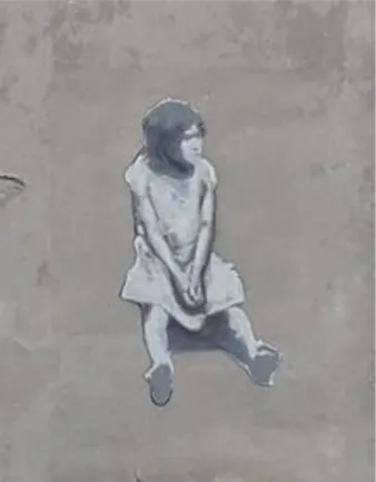
1.1 Industrial district « Canal Centre » concentrates small productive surfaces with a high ratio of derelict or unknown spaces and a very dynamic process of conversion, mainly into housing and public amenities. From Observatoire des activités productives presentation by De Voghel (2018), pp. 16, 22, 23. Retrieved from http://perspective.brussels/sites/default/files/documents/powerpoint_oap4_15_mei.pdf, 2018. ……….…..…… 4 1.2 Dominant Economic Use Map and categories (Giaretta et al., 2018, p.160). ………..…………. 6 1.3 Dominant Economic Use (right) and Economic Location Types (left) for the “Helmet” zoom in Schaerbeek, Brussel (Giaretta et al., 2018, p.165). ………..……… 6 1.4 Set of cumulative criteria for the selection of case studies spatially represented on a schematic plan of Brussels main infrastructures. Illustration B. Le Fort 2018 ……….……..……… 9 1.5 Morphological decomposition for the four case studies. Illustration B. Le Fort 2017 ……...………. 11 1.6 Masui case study by 2017 (source: Google 3D©). In yellow, the ERDF project implantation. The distinction is clear between neo-classical frontage and productive backyards. ………..……… 12 1.7 The “Quai du Charbonnage” case study by 2017 (source: Google 3D©). In yellow, the ERDF project implantation with the old industrial courtyard configuration. The residential densification of the waterfront is clear on the south (left) part of the block. ……… 12 1.8 The "Flour Mill" case study by 2017 (source: Google 3D©). In yellow, the ERDF project implantation. ………... 13 1.9 The “Quai de l’Industrie” case study by 2017 (source: Google 3D©). In yellow, the ERDF project implantation………..………. 14 1.10 Two built configurations and three depth configurations. Illustration B. Le Fort, 2017 ………..……… 15 1.11 . Plan and axonometry of semi-industrial spaces for the “Quai de l’Industrie” street front and urban block. The buildings concerned by the ERDF projects "Jardin d'Hiver - Libelco" and "crèche Liverpool" - surrounded in red in the axonometry - are on wide median plots with a homogeneous type of building (see details on fig. 8). Their transformation into a crossing public space and local amenity (kindergarten) considerably transforms the structure of the block. Illustration B. Fort 2017 ……….………… 17 1.12 “Quai de l’Industrie” case study: Analysis of industrial plot locations based on production axes. The three situations present different degrees of territorial depth. Illustration: B. Le Fort, 2017 ……….………. 18 1.13 Typological matrix (under construction) based on the two productive building configuration, the three depth configurations, building alignment and plot saturation. Illustration B. Le Fort, 2017 ……….. 20 1.14 Mixed Configuration Map (under construction, situation Mai 2018) showing ‘Config’ and ‘Typo’ attribute fields, zoom in Masui neighbourhood and Heyvaert neighbourhood. Illustration B. Le Fort 2018 ………...………..… 22 2.1 Population of Łódź 1820 – 2017. Data from Local Data Bank (2018), Dzieciuchowicz (2014). ………..………… 32 2.1 Alexander Nevsky Cathedral, Łódź. April 7, 2018. ………...……..………… 32 2.2 St. Olga’s Orthodox Church, Łódź. April 7, 2018 ………..………...………..………… 32 2.3 Part of Księży Młyn complex. An old spinning mill now functioning as a hotel, Łódź. December 7, 2017…..…… 34 2.4 Piotrkowska 217. Former Iron Foundry complex of Józef John currently operating as an open public space of culture and entertainment, Łódź. April 15, 2018 ………..……… 35 2.5 Girl from Roma community – mural located at Wojska Polskiego Street, Łódź, December 7, 2017. …………...…. 35
2.7 Examples of brands that are located in the OFF Piotrkowska complex, Łódź. December 7, 2017. …………...……. 38
2.8 The view on the front of the Łódź Fabryczna railway station, Łódź. December 7, 2017. ………...…… 39
2.9 The view on the main hall of Łódź Fabryczna railway station, Łódź. December 7, 2017. ………..… 40
3.1 Les Halles et les étals du marché extérieur ………..………..………..………… 48
3.2 Rue Jules Guesde. Source : lavoixdunord.fr (24/09/2015)…..………..……...………..…… 51
3.3 Les terrasses sur le Parvis de Croix. …..………..………...…..………...…… 52
3.4 Un étal de robe oriental.…..………..………..…………...…..…… 53
3.5 La fin du marché et le ramassage de légumes par un groupe de « roms » et passants. ……..………...……..…… 55
4.1 Localización de A Coruña, imagen portuaria de la Mariña y del Puerto Exterior de Arteixo. https://www.pinterest.com.mx/susanaopazorodr/ y http://www.diariodearteixo.com. ……….…………..…… 59
4.2 “Puertos interiores” y obras de la Mariña. Fuente: elaboración propia. ………...…………..…… 62
4.3 Vista frontal y posterior de la explanada de la Mariña. Fuente: elaboración propia. ………...….…………..…… 63
4.4 Material promocional del Puerto de A Coruña como destino crucerista. Fuente: http://www.puertocoruna.com/... 63
4.5 Playa del Parrote y antigua muralla de la ciudad a los pies de la Cidade Vella (arriba), y actuales instalaciones de “La Solana” y Hotel Finisterre (abajo). Fuente: Archivo Municipal. ………...………. 65
5.1 Mapa de localização do Centro de Campina Grande com destaque para o perímetro do núcleo central. LabRua (2015). ………...……… 76
5.2 Imóvel Vazio no Perímetro de estudo - Cine Capitólio. Thaís Paixão (2018). ………...………… 78
5.3 Gráfico de Porcentagem de Uso e Ocupação do Solo. LabRua (2018). ………...………...…… 80
5.4 Mapa de Uso e Ocupação do Solo do núcleo central. LabRua (2018) ………...………… 80
5.5 e 5.6 Gráfico de Imóveis ocupados e subutilizados por gabarito e Situação de Vacância na área. LabRua (2018)………...……….. 81
5.7 Gráfico da quantidade de pavimentos ocupados e desocupados. LabRua (2018). ………...………….. 81
5.8 Mapa de Lotes Vazios e Subutilizados. LabRua (2018) ……….………...……….. 82
5.9 - Simulação situação de vacância. Rua Marquês do Herval. LabRua (2018). ………...……….. 83
5.10 Simulação situação de vacância. Rua Venâncio Neiva. LabRua (2018) ………...………. 83
6.1 Anti-tourism graffiti in Lisbon historical centre (Authors, 2006) ………...………. 87
6.2 System limits ………..………...………...………...….... 96
6.3 External system - The two hills and the riverfront. ………. 97
6.4 The map represents the two subsystems present in the analyses ……… 97
6.5 Tuc-tuc parking lot at Praça da Figueira (Authors,2018) ………...………..…. 98
6.6 Street vendor Rua do Ouro/Praça do Rossio (Authors, 2018) ……...……...………..… 99
6.7 Tourism point at Praça do Rossio (Authors,2018) …..………...……….……….. 100
6.8 Elétrico 12 Rua dos Fanqueiros (Authors, 2018) …..…..………...……….……….. 101
6.9 Waiter at a restaurant of Rua dos Correeiros (Authors, 2018) ………..……….……….. 102
6.10 One of the oldest stores (since 1930) in Rua do Prata (Authors, 2018) ..……….……….. 102
6.11 Police officers at Praça do Rossio (Authors,2018) ..…..……….….……….……….. 103
6.12 Street cleaners at Praça do Rossio (Authors, 2018) ..………..……….……….. 103
8.1 Mapa de localização Campina Grande, PB, Brasil. Acervo LabRua, 2018 ………...……… 123
8.2 Mapa localização zonas festejos juninos. Acervo LabRua, 2018. ………...……….. 124
2018. ……….……...………..… 126
8.5 Parque do Povo.Site Sao Joao de Campina Grande, 2018. ………...………. 126
8.6 Mapa Parque do Povo - Layout 2017. Acervo LabRua, 2018. ………...………...……… 130
8.7 Linha do Tempo - São João. Acervo LabRua, 2018. ………..……….. 132
Tables Index
1.1 Characterization of the four case studies. ………..……….. 111.2 Coding for the four new fields in the "Mixed configuration Map" attribute table. ……….. 21
6.1 Chronology 1985/2018 - Lisbon and Baixa-Chiado. Sources: Daily Press (paper and websites), Architects Association Archive, Lisbon Council website ………..………..………….. 93
6.2 System Organization in PSSS Method (PSSS, 2018) ………...………..………...……….. 94
6.3 Services organization in PSSS Method (PSSS, 2018) ………..………..….. 94
6.4 Stakeholders organization in PSSS Method (PSSS, 2018) ……...………..………..….. 95
6.5 Values organization in PSSS Method (PSSS, 2018) ………...………..……….…… 96
8.1 Mobilidade. Acervo LabRua, 2018. ………...……… 133
8.2 Frequência x Faixa Etária. Acervo LabRua, 2018. ………...………. 134
8.3 Setores x Renda Familiar. Acervo LabRua, 2018. ………...……….………. 135
8.4 Opinião sobre Cercamento. Acervo LabRua, 2018. ………...………..………. 135
Introduction
Manuel Garcia-Ruiz
The Third International Conference of Young Urban Researchers, aimed to bring togher professionals, artists, general public, and researchers to talk about cities. The TICYUrb covered a big number of topics regarding the urban life, urban sociabilities and urban uses. In ProductCity we intended to go deeper, how the city is used, owned, sold, understood and transformed in terms of economic and symbolic value.
Cities have always been privileged places of production and transaction of material products and intangible goods (culture, norms, values). These aspects contribute to the polarization of political, economic and institutional power and affirmation of an arena of social demands necessary for the consolidation of democracy. Currently a set of multiple transformations and practices of territorial exploitation, arising from the context of economic crisis and financial globalization, are translated into the increasing centrality of the urban as a space for accumulation of capital and consumption. At the same time, socio-economic inequalities and environmental impacts are intensified and accelerated, extending beyond the geographic boundaries of urban or territorial borders. Considering this dual possibility of reading between the city as a space that activates flows, productive systems and 'varied goods' (or as merchandise itself) and the city as a space for democratic affirmation and social demand.
In this track we inveted works around touristification, gentrification, the now-called shared economies; city-branding, privatization of the urban space, mega-events; production of degenerated ecologies, etc. Here we have some of the papers presented in the conference:
We start with Barbara Le Fort who introduce us to the industrial urban fabric of Brussels. She presents here the first results of a typo-morphological analysis and a multi-level representation of the mix urban fabric in town She reviews these spaces, normaly occupied and with different functions ongoing, underlining their importance as key for an urban mutation
The identity of cities is always in transition, and Patrycja Grzyś bring here the case of the (post)industrial city of Łódź in Poland. She review the historical identity transitiong of this town, and questions about the processes of globalization, deindustrialization and other exogenous factors that may affect postindustrial cities’ identity and how cities are responding to this problem.
Karina Martos studies the transformation of a popular negbourhood with a dominant inmigration reception. She
presents to us a case study: Wazemmes neighbourhood in Lille (France), giving some ethnographic notes about the uses of the informal commerce and its urban space transformation.
Ports have always been important for cities, as reception and exportation of groceries and other merchandises, but as well to represent and important point for incoming and ongoing people. Alberto Rodríguez-Barcón, Estefanía
Calo and Raimundo Otero-Enríquez, presents here the transformation of the port of Coruña (Spain) and the
impact that meant for the nearby neigbourhood in terms of their touristification and real-state speculation.
LabRua (Aida Paula Pontes de Aquino, Beatriz Brito Mendes, Claudia Palmeira Lucena Amorim, Francisco
Allyson Barbosa Silva, Persio Padre de Macêdo and Thaís Rodrigues da Paixão) proceeded to inventorize the
available urban voids in Campina Grande (Brazil). This not-used but available spots of urban fabric demostrate (using mixmethods) that the city center has much more to offer, and that the city should reflect on them.
Continuing with the touristification Ana Brandão and Rita de Menezes Negrão presents a local case study: the Baixa of Lisboa (downtown Lisbon). Their work describes the changing urban dynamics of this important par of the city over the past decades particularly.
Events, festivals and fairs are very comon urban strategies to bring tourists, creat an urban brand and to get the city on map. Eloi Sendrós Ferrer and Alejandro Gorr bring us the case of ViJazz Penedès, an emergent wine and music festival that gather an important number of people as a result of a municipal plan for expanding the knowledge of their culture and products in a brandification process.
LabRua (Aida Paula Pontes de Aquino, Ana Clara Bezerra Guimarães, Beatriz Brito Mendes, Bruna
Almeida de Lima, Bruna França de Pontes, Iuzianny Rebeca Lopes Barbosa, Priscilla de Sales Brito, Raiff Mangueira Bezerra Nascimento) review one of the most traditional festivities on the portuguese speaking
countries: São Jõao. The study, taking place in Campina Grande (Brasil) reviews the modifications of the layout of this event over the years and investigates about the users' understanding of this physical layout
Daphne Assis Cordeiro presents and argue for the importance of the program “Lojas com Historia” (traditional
local historical business of Lisbon). This project auspiciated by the City Council tries to keep those important in time, and today-lasting shops that represent or had an importance on the history of the city.
Brussels Urban Recycling: Industrial Buildings as Resource
Barbara Le Fort | barbara.lefort@uclouvain.be
Catholic University of Louvain, Faculty of Architecture, Architectural Engineering, Urban
Planning
Abstract
As well as other European post-industrial metropolis, Brussels has inherited an important industrial building stock. Most of this stock is located along Brussels industrial valley and is made of warehouses, workshops and factories fully integrated with the surrounding dense urban fabric. This old mixed urban fabric, occupied by a mix of functions including small and medium economic activities, is undergoing an intense urban mutation for three reasons: a devaluated property land, a strategic central location and the heterogeneity of medium and large buildings and plots. Addressed from a spatial perspective, productive buildings integrated with the surrounding dense urban fabric can be seen as a resource for new space and projects. To address the gaps of detailed territorial and morphological knowledge about this resource, the paper presents the first results of typo-morphological analysis and multi-level representations of Brussels’ industrial mixed urban fabric.
Keywords:
urban recycling, typo-morphology, mixed urban fabric, Brussels, productive metropolis
Introduction
"Preserving Warehouses in the Heart of the City" was the headline of the Belgian daily Le Soir on 16 May (2018). Reporting on the decline of productive activity in the heart of Brussels, the article takes up the first findings presented in the latest publication of the Brussels Observatory of Economic Activities1. It shows that the city is facing an alarming decline in production areas, particularly dedicated to urban logistics, in its central industrial districts (De Voghel, 2018). The "Canal Centre" industrial district concentrates one third of Brussels' industrial surfaces. It has the highest industrial real estate vacancy rate associated with abandoned or unknown buildings and the highest conversion rate mainly to housing and public amenities (see figure 1). This tendency is the result of residential real estate pressure and numerous urban renewal projects (Collective, 2012; Vandermotten, 2014). This observation shows an increased competition between housing, schools and productive activities, in which the balance of power is in favour of the housing market (De Voghel, 2018).
Figure 1. Industrial district « Canal Centre » concentrates small productive surfaces with a high ratio of derelict or unknown spaces and a
very dynamic process of conversion, mainly into housing and public amenities. From Observatoire des activités productives presentation by De Voghel (2018), pp. 16, 22, 23. Retrieved from http://perspective.brussels/sites/default/files/documents/powerpoint_oap4_15_mei.pdf, 2018.
However, because of the increasing population with growing and new needs for supplies of goods, central districts need additional productive and logistics surfaces at the heart of urban fabric (Giaretta, Pennincx, De Mulder, & Zaman, 2018). Nowadays, it is difficult for public authorities to protect semi-industrial spaces, in particular by using pre-emptive right, since they are generally of small size, scattered throughout the urban fabric and, sometimes, even at the heart of a block. Above all, to date there is no typo-morphological study about these small industrial areas integrated into the dense urban fabric of the Brussels’ central industrial districts.
This paper will have three main objectives: Studying establishment conditions of traditional productive buildings into consolidated central urban fabric; producing a survey of Brussels’s traditional mixed urban fabric combining residential and productive built configurations; and showing the typo-morphological complexity of those urban fabrics.
We will start with a brief definition of the research object: Brussels’ mixed built fabrics. Based on this definition, we will establish an inventory of the accessible data and a state of the art of the representations and cartographies of these mixed fabrics in order to verify the relevance of a typo-morphological approach. We will then enter the heart of the research through the selection of relevant case studies and their typo-morphological analysis. From these initial reflections, we will establish a typology of productive building configurations enabling cartographic representation. The latter makes it possible to extrapolate mixed built fabrics types and to map these fabrics throughout Brussels’ territory. The last section of this article presents the first results of this method.
Mixed Built Fabrics
Semi-industrial spaces2 present in Brussels industrious valley are located inside consolidated urban blocks. These urban blocks were gradually saturated through densification and repletion processes consolidating a juxtaposition of small industries and workers’ modest raw houses in the same street front (Vandermotten, 2014). A functional mix made of various architectural typologies characterizes these blocks, with a very high degree of saturation. We call them “mixed built fabric”. The topological and typo-morphological complexity of this mixed built fabric associated with the presence of a semi-industrial activity explains why many urban recycling projects start from opportunities rather than a planned, holistic strategy.
Land Use at Block Level
There are already maps showing Brussels mixed urban fabrics but mainly from a land use perspective including socio-economic planning and regulatory spatial planning (De Beule, Périlleux, Silvestre, & Wauty, 2017). The 2001 factual land use situation census made for the Regional Land-use plan (PRAS) presented five levels of mixed-use urban blocks from very weak to very strong. Mixed-mixed-use criterion was calculated at the urban block level from a proportional ratio dividing office, industry and hotel plot areas by residential plot areas (PRAS, 2001). The resulting factual situation map was the base map for the regulation where urban blocks are characterizes in four land use categories: mostly residential, residential, mixed and high mix area. If the second map has evolved for more than fifteen years with a focus on housing3 (Vandermotten, 2014; De Beule et al., 2017) the base map has never been updated.
Archipelago of Detailed Surveys
To find detailed information, we need to look at local land use plans (PPAS), master plans (PAD), sustainable neighbourhood contracts (CQD) and urban renewal contracts (CRU). Those local urban renewal projects always come with a study of their morphological context. However, every design office has its own analysis method and the compilation of this detailed information does not exist yet. Moreover, these studies do not cover the whole urban region.
Dominant Economic Use Map
Based on the same observation of the knowledge gap about the location and differentiation of economic activities in Brussels metropolitan northern area, Federico Giaretta and Jan Zaman (2017) started to look at the mapping of economic activities. They built up a method based on an empirical approach, done by fieldwork and the construction of an inventory in order to “identify, locate and classify all the different types of existing economic activities” (Giaretta & Zaman, 2017, p.77). The resulting “Dominant Economic Use Map” (under construction) geo-localizes economic activities4 at the plot level (see figure 2).
Figure 2. Dominant Economic Use Map and categories (Giaretta et al., 2018, p.160).
Starting from GIS computation based on proximity between economic activities, Giaretta, Pennincx, De Mulder and Zaman (2018) defined four types of economic morphologies: “Continuous economic fabric, discontinuous economic fabric, disperse economic fabric and […] undefined economic fabric” (p.163). Combined with the “Dominant Economic Use Map” classification, Giaretta et al. defined 22 “economic location types” (p.164) (figure 3).
Figure 3. Dominant Economic Use (right) and Economic Location Types (left) for the “Helmet” zoom in Schaerbeek, Brussel (Giaretta et al.,
The “Economic Use Map” nowadays presents only a part of Brussels’ metropolitan area because of a very long fieldwork process. Moreover, these works give us a very interesting overview of economic activities morphological organisation. Focussing on economic activities, they are studying economic clusters and how economic activities are located in relation to each other. However, these research results do not address the issue of cohabitation between the economic and other functions of the city.
Plot Detailed Information, the Limits of Digitalized Cadastral Census
Digitalized cadastral census (UrbIS-Adm 2015 for Brussels-Capital Region) is another way to study and map mixed urban fabric. The limit is that these tools are mainly intended to collect taxes at property level. The open access version of the GIS database does not present typologies and mix of activities on a same plot. It gives us information on the cadastral nature of the principal activity on the plot, but nothing on buildings. Moreover, a land use clustering of cadastral natures is needed to map mixed built fabric in a legible way (IGEAT, 2010). Meanwhile this method masks the real morphological complexity5 and for 20% of plots, the cadastral land-related information does not match with the real land use (Grandjean et al., 2017).
Geometrical 3D Model
Moreover, the Brussels Regional Informatics Centre (BRIC) has developed UrbIS 3D a 3D model of Brussels’ Region but it is not possible yet to merge 3D information with land use information. The clipping of the 3D model layer with the PRAS’ mixed zones layer clearly shows the morphological complexity but does not help to understand how the urban fabric functions.
As we have seen, classical data (cadastre and regional planning) are not sufficient to have a good understanding of mixed urban fabrics functioning. On the one hand, land use data from regional planning are not detailed enough. On the other hand, it is too hard to get and use the cadastral data and they are often inaccurate in relation to the actual land use. An archipelago of detailed surveys is under construction but not always with the same objective, the same method and the same tools of representation. They do not cover the entire urban region and the mix of data types makes the compilation impossible. Moreover, all of these mapped surveys are focusing on land use and consider economic activities in opposition with the residential function. At least, we do not find qualitative information on an architectural level of understanding. To answer this knowledge gap, we hypothesize that the understanding of the mixed built fabrics functioning is built on the typo-morphological study of their forms and architectures.
Method
Based on research on typo-morphology of Brussels urban fabrics (Lacour, Delhaye, & Dumont, 1987; De Visscher, 2013; Ledent, 2014), this paper presents a typo-morphological exploration based on the built configurations that organize mixed urban blocks. “Types” correspond to the regrouping of similar architectural configurations based on morphological criterion. This working method proposes an alternative to case-by-case analysis. It synthesizes
and systematizes information to approach on a global point of view the complexity of industrial urban fabrics. At least, it enables useful territorial comparisons (Le Fort, Vanderstraeten, & Hanin, 2014).
Typo-morphology
Presenting interrelated reading levels, from the build piece to the territorial organization, typo-morphological analysis is a way to describe and represent morphological complexity, and to highlight the richness and urban qualities of mixed built fabrics.
Concept
Detailed territorial and morphological knowledge of the territory starts with a study of urban forms at different spatial scales. The typo-morphological approach considers the structural influence of the built context and studies the existing urban structures in order to highlights permanent morphological characteristics (Rossi, 1966; Caniggia, Malfroy, Demeur, & Matthu, 1994; Caniggia & Maffei, 2000). It considers the hypothesis of an internal logic in the organization of the urban fabric, of an order that conditions simultaneously urban growth and social practice (Castex, et al., 1980).
Usage of Types
We start in an inductive way from case studies for the development of types. Types are built per rational abstraction starting from the common properties of the objects (Panerai, Depaule & Demorgon, 1999). In a second time, types are used in a deductive way in order to analyse and represent a very wide and complex territory.
Criteria for the Definition of Urban Fabrics
The imbrication of three urban components composes urban fabrics: street network, plots pattern and buildings (UNESCO, 1984, Panerai, et al., 1999).
Recent English studies on high streets bring a new dimension to the definition of criteria for the analysis of mixed built fabrics (Porta & Romice, 2010; Carmona, 2014; Clossick, 2017). Considering high streets as "mixed street corridors" (Carmona, 2014), they stress the importance of the street front as a relevant study scale (Porta & Romice, 2010). Conditions of spatial relation between the establishment of the industrial activity and the street are thus essential. Urban researchers call “depth” the space configurations which give access, through devices of transitions, of a space - public space - towards another - private space6 (Habraken & Teicher, 2000; Carmona, 2014; Clossick, 2017). Street front depth then is a key factor to accommodate industrial, manufacturing or logistic activities inside urban fabric. Axonometric design is then the best way to represent and study the depth organization of the street front (Clossick, 2017).
Based on these findings, our study starts from the morphological analysis of buildings and plots, considered as first urban elements. The approach gradually zooms out in order to characterize the structure that binds urban elements (the urban fabric); then to understand the systems that bind urban fabrics, and finally to represent the territorial organization that integrates systems (Caniggia & Maffei, 2000). Our analytical grid to address case studies is built on the conjunction of three components: plots patterns, built patterns and depth. The street front is the pertinent base scale for urban fabric analysis.
Case Studies as Starting Points
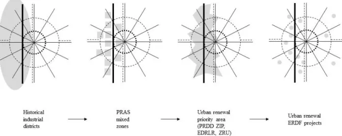
Case studies are selected based on cumulative criteria mixing morphology, land use and urban renewal dynamics (see figure 4). The objective is to find paradigmatic mixed built fabrics that are undergoing an urban mutation.
Figure 4. Set of cumulative criteria for the selection of case studies spatially represented on a schematic plan of Brussels main infrastructures.
Illustration B. Le Fort 2018
General Morphogenesis
During the XIXth and XXth centuries, the development of canals and railway infrastructures and the draining of swamps along the Senne River drove Brussels industrial development phases. Industrial installations and workers’ houses particularly boosted the urban development of the Old Molenbeek, Heyvaert and Masui neighbourhoods, the first Brussels industrial suburbs. These neighbourhoods still today host a large number of warehouses and active workshops (Lacour et al., 1987; Collective, 2012; Vandermotten, 2014; De Voghel, 2018).
Strategic Mixed and Productive Urban Area
These neighbourhoods are situated in the Canal Zone, an urban renewal priority area (Zone d’intérêt prioritaire ZIP in the Regional Sustainable Development Plan PRDD project (2017), which covers most of the mixed urban
blocks (PRAS, 2001) and forms a corridor for production and logistics (de Beule, 2012). This wide urban area presents a variety of mixed built fabric configurations related to their period of development.
Urban Renewal Projects as Vehicles for Mixed Built Fabrics Mutation
Public action focusses its urban renewal projects on Brussels central industrial districts because of socio-economic challenges. Indeed, these districts concentrate high building coverage ratio with high density of population with low income and low education level (Nakhlé & Raynaud, 2014; Vandermotten, 2014). In order to improve the living conditions of these neighbourhoods, urban regeneration projects are following three development axes: socio-cultural actions; creation of social housing; and creation of public facilities, including new public spaces.
Concretely, urban fabric transformations inside the Canal Zone are two-fold. The first one is about building by recycling, retrofitting or replacing. This is mainly led by private developers, or by public actors via a sustainable neighbourhood contract. The second one transforms the urban fabric structure via the creation of new public spaces inside the urban block following two strategies. On the one hand, redevelopment projects are taking place on existing urban infrastructure in order to design a more inclusive urban space for urban dwellers. On the other hand, we see rehabilitation of vacant land or demolition of buildings in order to create new public spaces. It occurs on publicly owned plots that have not been developed yet because of their isolation within the urban fabric. However, it also occurs on private industrial buildings. The latter are attractive for developers because of three factors: • their plot and building sizes, large enough to welcome different sort of programs;
• their localization within the dense urban fabric close to inhabitants who could directly benefit from the new amenity;
• and their low-cost land, although this factor is tending to disappear with increasing real estate pressure.
European Regional Development Fund (ERDF) contributes to the financing of projects intended to strengthen the Region's economic, social and territorial cohesion. Unlike other metropolises that have decided to concentrate ERDF funds on large urban projects (i.e. Charleroi), Brussels has chosen to distribute them among 46 projects for its 2014-2020 program. More than half of these projects have a structural impact on the built environment and fall within the scope of the Regional Sustainable Development Plan (PRDD). The majority of them participate in the Canal Zone urban renewal process. By their innovative and short-term dimension, they question urban policies and generate new kinds of projects processes. They are pertinent examples of mixed built fabric mutation.
Case Studies Selection
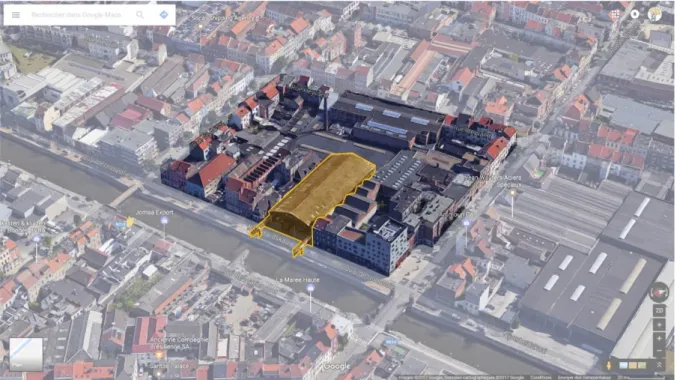
The selection of case studies follows this cumulative set of criteria: it should be a street front situated in old central industrial districts (Masui, Old Molenbeek, and Heyvaert) > in a mixed urban blocks as defined in the PRAS > inside the ZIP and hosting an ERDF urban renewal project (see figure 4). We start our analysis on four street fronts: “Masui”, “Quai du Charbonnage”, “Flour Mill” and “Quai de l’Industrie”. They all hosts a ERDF project with different kind of transformation type, project objectives, and stakeholders (see table1). This selection offers us a quick look at different types of urban renewal projects in the Brussels’ Canal Zone.
Street front case study name ERDF 2020 projects Historic industrial districts Transformation type
Project objectives Stakeholder
“Masui” “Masui4Ever” Masui Building renovation
Optimization and opening of the space Private (association) “Quai du Charbonnage” “Charbonnage kindergarten”
Old Molenbeek Demolition - reconstruction
New public amenities with public gallery
Public (municipality)
“Flour Mill” “Castii” Old Molenbeek Building renovation
Improve fab lab visibility and accessibility from street
Private (association)
“Quai de l’Industrie”
“Grande Halle” Heyvaert Demolition - reconstruction
New public square and new kindergarten
Public (municipality)
Table 1 Characterization of the four case studies.
Heterogeneous Plot Patterns
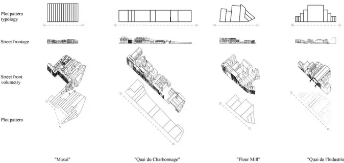
To figure out the complexity of the four selected street fronts, we propose to decompose them and to distinguish plot patterns from building configurations – street front volumetry and street frontage (see figure 5). Firstly, looking at plot configurations, the exercise shows 4 different plots patterns. Each of them presents a specific plots organization inherited from its morphogenesis and biography.
Figure 5 Morphological decomposition for the four case studies. Illustration B. Le Fort 2017
The “Masui” case study presents a regular pattern composed of 6-meter wide and very profound plots (see figure 6). The homogeneous neo-classical frontage frames a public square created between 1858 and 1865 on the Royal Axis (Rue des Palais), where it forms an angle. This explains the homogeneous plot pattern made of raw houses with carriage gate at the front and warehouses at the back.
Figure 6 Masui case study by 2017 (source: Google 3D©). In yellow, the ERDF project implantation. The distinction is clear between
neo-classical frontage and productive backyards.
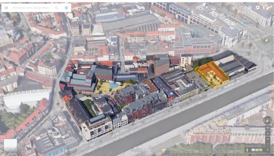
The “Quai du Charbonnage” case study presents a regular pattern composed of wide and nearly square plots. These plots were agricultural fields forming a strip wedged between the Small Senne River and the moats of Brussels second medieval walls. From 1850s, after the digging of the Canal of Charleroi, these plots were developed by industrials finding there a perfect localization in terms of infrastructure connectivity and plot size7. Industrial buildings were organized around a courtyard. Showrooms and bosses’ houses were located in front of the canal, the commercial and prestige axis. Stables, warehouses and workshops were located at the back using Small Senne River as a sewer. Nowadays, a new urban waterfront made of apartment buildings and lofts replaces most of the industries (see figure 7).
Figure 7 The “Quai du Charbonnage” case study by 2017 (source: Google 3D©). In yellow, the ERDF project implantation with the old
The “Flour Mill” case study presents a random plot pattern composed of wide and deep trapezoidal plots. This very particular heterogeneous distribution comes from a spatial cutting framed by an old triangular bastion of Brussels’ medieval fortification. Popp’s cadastral surveys (1866) indicates the co-presence of raw houses with workshops and an important steam mill with starch factory8 organized around a big courtyard, which was gradually densified following the logic of “massive repletion of all urban blocks along the canal” in a development “of linear pace […] tangentially to the canal” (AAM, 1980). The street front is nowadays filled in with a mix of buildings types made of old warehouse and factory frontages hosting creative and craft economic activities, houses, lofts and new apartment buildings (see figure 8).
Figure 8 The "Flour Mill" case study by 2017 (source: Google 3D©). In yellow, the ERDF project implantation.
The “Quai de l’Industrie” case study (see figure 9) shows an evolving plot pattern following a “Gauss distribution” of plot shapes and sizes. Small plots take place on street front extremities, resolving angle situation with small corner shops. Wide and deep plots take place in the middle of the street front for the establishment of factories and big warehouses. The analysed street front is part of an mixed urban block urbanized between 1868 and 1899 following the industrial development of Heyvaert neighbourhood, on both sides of the new canal of Charleroi (inaugurated in 1832). Upon request from industry companies in order to develop their activities, a regular layout of streets forming large blocks was designed through agricultural parcels. The resulting plot pattern seems to answer the need of a balanced urban environment mixing factories, warehouses, small workshops, bosses’ and workers’ raw houses and small corner shops (see details below).
Figure 9 The “Quai de l’Industrie” case study by 2017 (source: Google 3D©). In yellow, the ERDF project implantation.
Those four street fronts show a variety of plot patterns resulting largely from a long urban mutation history and by a wide set of factors. Each configuration shows a different frontage type. This first reading level reveals the complexity of plot distributions in Brussels’ mixed urban fabrics.
Productive Building Configurations
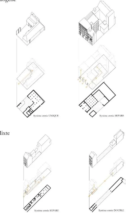
The second reading level concerns building typologies and their correlation with plot shape and street front morphology. Brussels mixed urban fabrics are specific because of the imbrication of productive buildings with Brussels typical raw houses. Focusing on the analysis of traditional productive buildings, we distinguish two types of building configuration on a plot: homogeneous and mixed (see figure 10).
Figure 10 Two built configurations and three depth configurations. Illustration B. Le Fort, 2017
The homogeneous configuration concerns plots where all buildings are exclusively designed to host a productive, logistic or economic activity, including administrative spaces. They are established on large and deep plots of a street front.
The mixed configuration concerns plots with more than one building, with a residential frontage, sometimes with ground floor shop, and small productive buildings like workshops and warehouses in the backyard. This configuration may present various readable nuances on and through the street front ground floors:
• Mixed frontage initially made up to allow access to back yard: Artisanal activities (workshop), industrial (warehouse, small factory) or logistics (stables) were integrated with the very first design of the frontage in a balanced architectural composition.
• Residential frontage, which was transformed to enable the access to the back yard: Semi-industrial spaces were built as a second step after the constitution of the frontage with a high risk of architectural denaturation.
Built and Plots Shapes Correlation
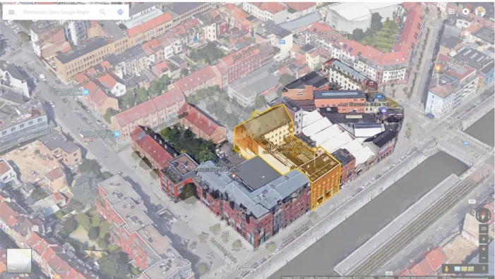
The “Quai de l’Industrie” case study is paradigmatic of the correlation between built configurations, plot shapes and plot organization inside the mixed urban block. Plot pattern translates a typological heterogeneity benefitting from the various conditions of establishments (see figures 11 & 12). We then observe in the same street front: large semi-industrial urban settlements, small urban workshops, commercial ground floors with inhabited floors.
Figure 11. Plan and axonometry of semi-industrial spaces for the “Quai de l’Industrie” street front and urban block. The buildings concerned
by the ERDF projects "Jardin d'Hiver - Libelco" and "crèche Liverpool" - surrounded in red in the axonometry - are on wide median plots with a homogeneous type of building (see details on fig. 8). Their transformation into a crossing public space and local amenity (kindergarten) considerably transforms the structure of the block. Illustration B. Fort 2017
Figure 12. “Quai de l’Industrie” case study: Analysis of industrial plot locations based on production axes. The three situations present
different degrees of territorial depth. Illustration: B. Le Fort, 2017
On broad and major plots on the medians of the rectangle, we find configurations that accommodate an industrial homogeneous architectural typology (standard factory, large warehouse, etc.) with a direct physical and visual relation from industrial space to the street (only a few buildings are offset, most of them are established on the alignment).
At the corner of the block, on crossroad, narrow plots (6m) without depth are difficult to inhabit. However, they are strategic places to establish a corner shop or restaurant at the ground floor.
Finally, between the median and the angle, we find intermediate size plots whose width is a module of 6m and host mixed building typologies. Physical and visual relation between street and productive buildings in the backyard works in second plan via the crossing of the consolidated residential built frontage (via carriage gate).
Street Front Depth, the Strategic Condition for Backyard Semi-Industrial Areas
Street front depth is translated physically and spatially into three depth configurations associated with productive buildings configurations (see figures 10 and 12). In the homogeneous productive building configuration, the “single” configuration [système unique] presents the interface of only one type of space, a warehouse for example. The “separated” configuration [système séparé], also present in the mixed configurations, dissociates logistic entries – suitable access for motor vehicles to productive spaces or storage spaces – from administrative or deprived – pedestrian access to office spaces or residential spaces. Finally, the “double” configuration [système double] integrates both logistic and private access via only one entry. In this configuration, the access is shared between the inhabitants – users of residential spaces on the street side – and the users of semi-industrial spaces at the back.
In building mixed configurations, the depth allows a high relational potential between the public space and the heart of the semi-industrial block. This relation potential, combined with the mix of plot and architectural typology, contributes to the intensity of mixed urban fabrics. Because they enable functional mix and adaptations, these mixed morphologies therefore function as resilient metabolisms (Clossick, 2017).
From Case Study Analysis to Typology
We have seen in the typo-morphological analyses of the case studies that the building configuration – mixed or homogeneous – of productive buildings is the basis of the morphological definition of mixed built fabrics. The depth configurations of mixed street fronts provide valuable additional information regarding the potential relationship that exists between the street, the built front and the economic activity in the back yard.
These two criteria – building configuration and depth configuration – serve as the basis for a typological matrix to which we add a criterion looking at the establishment of the buildings on the plot (see figure 13). This last criterion presents four establishment situations: saturated, on court, recessed or opened. It offers two information. On the one hand, it indicates the building coverage ratio on a plot and thus the opportunity for densification or the need for a desaturation. In addition, it gives an indication about the activation of public space. Saturated and on court establishments present a street frontage aligned on the Brussels consolidated built front made of raw houses. The semi-industrial façades contribute to the activation and intensification of public space. Opened and recessed establishments offer visual openings in the built fabric.
Figure 13. Typological matrix (under construction) based on the two productive building configuration, the three depth configurations,
building alignment and plot saturation. Illustration B. Le Fort, 2017
Mixed Configuration Map, First Results
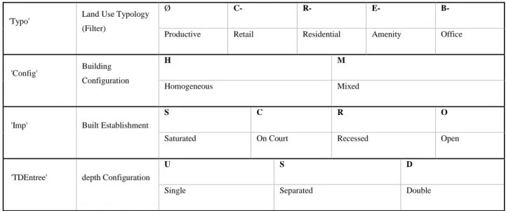
The – under construction – resulting map is built from the 2015 version of the Brussels cadastral matrix (UrbIS-Adm, buildings and plots) with QGIS as interface to create the data. We created four new fields in the attribute table of the UrbIS-Adm plot layer (see table 2) to code information at plot level:
• ‘Typo’ defines which main activity on the ground floor (street front and backyard). This criterion serves as a filter to enhance productive building configurations to other types of urban functions.
• ‘Config’ defines the built configuration on a plot – homogeneous or mixed.
• ‘Imp’ defines location types of buildings on a plot – saturated, on court, in offset or opened. • ‘TDEntree’ defines depth configurations – single, separated or double.
'Typo' Land Use Typology (Filter)
Ø C- R- E- B-
Productive Retail Residential Amenity Office
'Config' Building Configuration
H M
Homogeneous Mixed
'Imp' Built Establishment
S C R O
Saturated On Court Recessed Open
'TDEntree' depth Configuration
U S D
Single Separated Double
Table 2 Coding for the four new fields in the "Mixed configuration Map" attribute table.
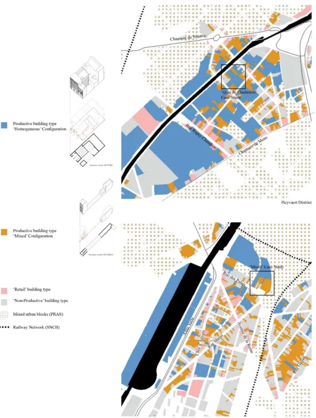
For a first exploration, the aim is to represent a global photography of mixed built fabrics, not the exact actual situation. UrbIS-Adm plot and built layers, bruciel.brussels, Google Maps 3D and Street View are the first data collection tools to fill in the new attribute fields. In a second time, site visits will verify the first exploration. The coding and the mapping of built and depth configurations enables us to show the mixed built fabric complexity. The resulting map enhances different modes of morphological coexistence between productive, mixed, commercial typologies and “non-productive” (residential/offices/amenities) typologies (see figure 14).
Figure 14 Mixed Configuration Map (under construction, situation Mai 2018) showing ‘Config’ and ‘Typo’ attribute fields, zoom in Masui
neighbourhood and Heyvaert neighbourhood. Illustration B. Le Fort 2018
In this paper, we will focus on Heyvaert neighbourhood and Masui neighbourhood. These two neighbourhoods show mixed built fabric organized at different scale in mixed plots, in mixed street fronts and along mixed corridors. The “Quai du Charbonnage” and the “Flour Mill” case studies will not be presented in this paper because they are not entirely drawn yet. Moreover, they have already undergone a major built fabric transformation. They
have lost much of their functional and typological mix and now house a majority of apartment buildings creating a new canal waterfront.
The Mixed Configuration Map, for Heyvaert neighbourhood, with the “Quai de l’Industrie” case study, shows different mixed built fabric configurations. The relative regularity of blocks shapes comes from XIXth century planned extensions of Brussels (Besme, 1866). Square mixed block around “Quai de l’Industrie” case study present the same “Gauss distribution” configuration that presented in detail above. However, we observe commercial nodes configuration at street crossings and commercial axes on Chaussée de Ninove, Chaussée de Mons and Rue Ropsy-Chaudron (see figure 14, above).
In the case of the Masui neighbourhood, the Mixed Configuration Map shows other mixed built fabric configurations. The heterogeneity of Masui blocks shapes comes from the overlapping of historic and infrastructure layouts between the end of XIXth century and the early XXth century9 (Lacour et al., 1987; Demey, 2008). We observe two commercial axes: Chaussée d’Anvers and Avenue de la Reine; crossed by three economic axes: Rue des Palais, Allée Verte and Rue Masui (see figure 14, below). Homogeneous productive configurations are quite rare and take place on large and deep plots, on the north and south parts of the neighbourhood and along the Allée Verte, in front of the harbour. Mixed productive configurations are mainly organized along Rue Masui and in small streets associated with Chaussée d’Anvers. The “Masui” case study street front configuration is an exception in the neighbourhood.
Conclusion
The first exploration of Brussels’ mixed built fabrics shows us that the building homogeneous and mixed configurations and the three depth configurations are found on all the Canal Zone territory and beyond other productive axis as the old radial commercial roads. However, their layout within street fronts and urban blocks varies. This variation is in particular the fruit of the morphological evolution through various phases of Brussels’ urban development (Lacour et al., 1987).
By the typo-mophological angle, this research brings new knowledge to define mixed urban fabric at different scale. The first results argue for a multiscale analysis and multiscale representations to characterise Brussels mixed urban fabrics. Indeed we observe a typological mix at the scale of the building, at the scale of the plot, at the scale of the street and finally at the scale of the district. These different scales must be considered in urban planning projects that envisage the protection and strengthening of functional diversity. Moreover, to consider mixed-use configurations, Brussels urban planners need to stop thinking Brussels’ territory in terms of urban blocks but well in terms of street fronts.
A new geography of Brussels mixed urban fabrics emanates, where industrial buildings integrated with the urban fabric is a resource (Collective, 2012; De Voghel, 2018). However, this resource is under pressure. On the one hand, economic actors are looking for increasingly scarce semi-industrial spaces in the heart of the dense city. On the other hand, urban renewal actors are seeking for project opportunities to improve the living environment of
these neighbourhoods. In addition, an ongoing critical reflection analyses the structural mutation of these mixed urban fabrics following Brussels urban renewal policies and the new kinds of project processes they generate. For this reason, the follow-up of some Brussels ERDF projects – in particular those integrated into the sustainable neighbourhood contracts and urban renovation contracts – reveal a new operational and political angle on the matter.
References
AAM - Archives d’Architecture Moderne (1980). Inventaire visuel d’architecture industrielle de Bruxelles, Molenbeek 2, Ministère de la communauté française, Bruxelles
Caniggia, G., Malfroy, S., Demeur, S., & Matthu, R. (1994). Lecture de Florence (Vol. 18). Bruxelles: Institut Supérieur d'Architecture Saint-Luc Bruxelles.
Caniggia, G., & Maffei, G. L. (2000). Composition architecturale et typologie du bâti : 1. lecture du bâti de base. Versailles: Ville Recherche Diffusion.
Carmona, M. (2014). London’s Local High Streets: The Problems, Potential and Complexities of Mixed Street Corridors, Progress in Planning, 100 (August 2015): 1–84.
Castex, J., Céleste, P., Panerai, P., Burlen, K., & Furet, C. (1980). Lecture d'une ville: Versailles. Paris: Moniteur.
Clossick, J. (2017). The depth structure of a London high street: a study in urban order, PhD thesis, London Metropolitan University
Collective (2012). Observatoire des activités productives #1, évolution 1997-2011, Citydev & Bruxelles Développement urbain (BDU), Région de Bruxelles-Capitale
De Beule, M., Boswell, R., Doornaert, A., & Hanssens, B. (2012). Observatoire des activités productives. Evolution 1997 - 2011. Brussels Regional Development Agency
De Beule, M., Périlleux, B., Silvestre, M., & Wauty, E. (2017). Bruxelles, histoire de planifier. Urbanisme aux 19e et 20e siècles, Ed. Mardaga, Brussels
De Visscher, J.-P. (2013). Indivision, thèse de doctorat Université catholique de Louvain, Prom.: Stillemans, Jean, Louvain-la-Neuve
De Voghel, C. (2018). Observatoire des activités productives n°4, le défi de l’immobilier logistique. Slide presentation, Bruxelles Mobilité, CityDev & perspective.brussels, Région de Bruxelles-Capitale.
Retrieved from
http://perspective.brussels/sites/default/files/documents/powerpoint_oap4_15_mei.pdf (2018)
Demey, T. (2008). Un canal dans Bruxelles, bassin de vie et d’emploi, éd. Badeaux, Bruxelles
Giaretta, F., & Zaman, J. (2017). Can an Economic Activities Inventory Fill the Knowledge Gap about the Economic Sector in a Policy Making Process? REAL CORP 2017 – PANTA RHEI – A World in Constant Motion. 22nd International Conference on Urban Planning, Regional Development and Information Society. pp. 77-86.
Giaretta, F., Pennincx, I., De Mulder, S., & Zaman, J. (2018). Defining Economic Typologies based on an Economic Activities Database. REAL CORP 2018 – EXPANDING CITIES – DIMINISHING SPACE. Are “Smart Cities” the solution or part of the problem of continuous urbanisation around the globe? 23rd International Conference on Urban Planning, Regional Development and Information. pp. 159-168
Grandjean, M., Marlier, C., Hawotte, F., Khalil, E., Romain, J., & Defourny, P. (2017). Systèmes d’informations foncières et politiques publiques, Rapport final de la subvention 2017, CPDT, Rapport de recherche, 94 p.
Habraken, N. J., & Teicher, J. (2000). The Structure of the Ordinary : Form and Control in the Built Environment. Cambridge, Mass.: MIT Press.
IGEAT (2010). OSIRIS : Organisation of Statistical Information for Research by Institutions and Scientists. Rapport de recherche, 309 p.
Lacour, M., Delhaye, I., & Dumont, M. (1987). Morphologie urbaine à Bruxelles, Centre d'étude, de recherche et d'action en architecture, Bruxelles
Le Fort, B., Vanderstraeten, P., & Hanin, Y. (2014). Walloon Urbanized Fabric Typology Method of Identification of the Walloon Urbanized Fabrics Applied to the Commune of Ath, Territoire(s), Vol. 0, no.3, p. 1-27, October 2014.
Ledent, G. (2014). Potentiels relationnels : l'aptitude des dispositifs physiques de l'habitat à soutenir la sociabilité : Bruxelles, le cas des immeubles élevés et isolés de logement, thèse de doctorat Université catholique de Louvain, Prom. : Olivier Masson, Louvain-la-Neuve
Nakhlé, L. F., & Raynaud, F. (dir.) (2014). Canal ? Vous avez dit canal ? ! Etat des lieux illustré du territoire du canal à Bruxelles, Région de Bruxelles-Capitale, Agence de développement territorial
Panerai, P., Depaule, J-C., & Demorgon, M. (1999). Analyse urbaine, éditions Parenthèses, France.
Porta, S., & Romice, O. (2010). Plot-Based Urbanism: Towards Time-Consciousness in Place-Making, working paper, UDSU – Urban Design Studies Unit, University of Strathclyde, Dept. of Architecture, Retrieved from http://www.udsu-strath.com/wp-content/uploads/2011/11/Plot-Based-Urbanism_10_OR-SP-FINAL_low-res.pdf
PRAS (2001). Plan Régional d’Affectation du Sol, Brussels Capital Region. Retrieved from http://perspective.brussels/fr/plans-reglements-et-guides/plans-reglementaires/plan-regional-daffectation-du-sol-pras
PRDD (2017). Plan Régional de Développement Durable (project), Brussels Capital Region. Retrieved from http://www.prdd.brussels/
Preserving Warehouses in the Heart of the City (2018, May 16). Le Soir, p.32
Rossi, A. (1990). L'architecture de la ville. Paris: Livre & Communication.
UNESCO (1984). Méthode d’analyse morphologique des tissus urbains traditionnels, études et documents sur le patrimoine culturel, http://unesdoc.unesco.org/images/0006/000623/062310fb.pdf (22/05/2018)
Vandermotten, C. (2014). Bruxelles, une lecture de la ville : de l'Europe des marchands à la capitale de l'Europe. Bruxelles: Éd. de l'Université de Bruxelles.
Cartographic Resources
Besme, V. (1866). Plan d'ensemble pour l'extension et l'embellissement de l'Agglomération bruxelloise bruciel.brussels, retrieved from http://bruciel.brussels/UrbIS-Adm, Brussels Regional Informatics Centre (BRIC), 2015 version, retrieved from https://cirb.brussels/fr/nos-solutions/urbis-solutions/urbis-data
Google Maps, 3D mode
Google Maps, Street View mode
Popp, P. C. (around 1858). Atlas du Royaume de Belgique, plan parcellaire de la commune de Schaerbeek
Popp, P. C. (1866). Plan parcellaire de la commune de Molenbeek-Saint-Jean avec les mutations. Atlas cadastral de Belgique. Province de Brabant. Arrondissement de Bruxelles, canton de Molenbeek-Saint-Jean. Publié avec l’autorisation du gouvernement sous les auspices de le ministre des Finances
Popp, P. C. (1866). Tableau indicatif et matrice cadastrale. Province de Brabant. Arrondissement de Bruxelles, canton de Molenbeek-Saint-Jean. Publié avec l’autorisation du gouvernement sous les auspices de le ministre des Finances
UrbIS 3D. Retrieved from http://urbisdownload.gis.irisnet.be/fr/temporality/
Vandermaelen, P. (1830-1878). Cartes et plans de la Belgique, Établissement géographique de Bruxelles
Footnotes
1 Brussels Observatory of Economic Activities is a statistical analysis tool founded in 2012 and based on land survey on
production, logistics and storage activities. It assesses the evolution of the use of factories and depots and the importance of the vacancy in the stock of workshops and depots in the Brussels-Capital Region.
2 Term used by the brokers to aggregate productive activity and logistics (De Beule, Boswell, Doornaert, & Hanssens, 2012). 3 The second evolution of the PRAS, the “PRAS Démographique” translates increasing need for dwellings, by the creation of
ZEMU, Zone d’Entreprises en Milieu Urbain: a new frame for developing new opportunities for residential constructions in industrial zones.
4 “Economic activities are defined as places or units in which an economic use is visible and recognizable or as sites designed for
an economic use” (Giaretta & Zaman, 2017, p.80).
5 In 2015, AGDP (General Administration of Patrimonial Documentation, Federal Public Service of Finance) changed the
architecture of its database. It is now possible to obtain the information of the number of buildings and the number of owners on a parcel. In facts, firstly, it is difficult to obtain the database, and secondly, it is hard to play with it in order to extract a legible map or spatial mixed-use representation (Grandjean et al., 2017).
6 In our case, private space is that of the company which occupies semi-industrial space. 7 See Vandermaelen P. (1858) Topographic Map
8 See Tableau indicatif et matrice cadastrale of POPP’s Atlas cadastral parcellaire for Molenbeek-Saint-Jean (1866).
9 The River Senne (covered around 1930), the Willebroeck Canal expansion and the Vergote Dock, the rail network development
Creating new urban identities in the era of global urban competition.
Experience of polish postindustrial cities.
Patrycja Grzyś | patrycja.grzys@phdstud.ug.edu.pl
University of Gdańsk, Department of Spatial Management, Faculty of Oceanography and
Geography
Abstract
This paper attempts to examine the problem of urban identity. The basic thematic scope of this work is based on the issues of the contemporary changes within the urban environment in the context of postindustrial cities. The first part of the article is a terminological consideration regarding to the concept of urban identity. The following parts are related to the specific case of a Polish postindustrial city: the city of Łódź located in the Central Poland. The main aim of this paper is thus to examine how the processes of globalization, deindustrialization and other exogenous factors affect postindustrial cities’ identity and how cities are responding to this problem.
Key words
urban identity, postindustrial cities, Łódź, globalization
Urban identity: Terminological discussion
Identity is currently a subject of dynamic discourse. The use of this term requires particular caution, since it is used by a large number of scientific disciplines. Inaccuracy or inconsistency in terminology can therefore be a reason of large number of the controversies or misunderstandings. Consequently, at the outset, it is worth to define and clarify the scope of the use of this concept within this paper, as to avoid described misunderstandings.
Identity is not a new research construct. It has a long history, although the current understanding of this term can be dated to the beginning of the 20th century. Basic considerations about identity were embedded in two trends: psychological and sociological. Both approaches referred to the individual’s identity. Erikson (1959) as the representative of the psychoanalytic concept, was focused on the subjectivity and personal experience in the context of individual’s identity, while James (1890), the creator of the “theory of self” or later Goffman (1959) and Berger (1963) as representatives of the sociological approach, were focused on the role of society in constructing the subjective “I” of a man. Erikson (1959) is recognized as responsible for the contemporary meaning of the identity term and what is more, for introducing the term “identity crisis”, which initially referred to Erikson’s patients who felt the loss of a sense of identity and continuity. However, currently both the term and its meaning can be successfully applied to contemporary identity crisis in the case of the urban environment.
One of the scientific disciplines that has implemented the term identity in its terminology is geography. Geography analyzes the identity primarily in relation with territoriality. Urban-related identity has a relatively short tradition.