Overwash hazard assessment
B.A. RODRIGUES A. MATIAS Ó. FERREIRA
FCMA/CIMA, Universidade do Algarve, Campus de Gambelas
8005-139, Faro, Portugal. Fax: +351 289 800696. Rodrigues E-mail: [email protected] Matias E-mail: [email protected] Ferreira E-mail: [email protected]
A B S T R A C T
Overwash is a natural storm-related process that occurs when wave runup overcomes the dune crest. Because coastlines are globally occupied, overwash is a hazardous process and there is a need to identify vulnerable areas. This study proposes a method to detect overwash-prone areas in the Ancão peninsula, Portugal, and eventually
outlines a vulnerability map. Dune base (DLOW) and crest (DHIGH) topography were surveyed. Three different storm
scenarios (5-, 10- and 25- year return period storms) and associated waves and sea level were determined.
Accord-ing to these data, extreme wave runup (RHIGH) was calculated by a parameterisation set for intermediate-reflective
beaches. The maps for collision and overwash regimes were designed by comparing RHIGH values with DLOW and
DHIGH. Almost the entire dune base along the peninsula is vulnerable to collision regime. The overwash process
was identified mainly along the tidal inlet hazard area and within the human-occupied portion of the beach, where overwash is expected to occur within 5 years of return period. The developed method considers the main overwash driving forces and proved to identify hazardous areas previously observed in the area. Occasional differences between modelled and observed overwash areas can be attributable to equipment errors, morphology interpreta-tion subjectivity and maladjustments in runup parameterisainterpreta-tion. Nevertheless, the method proved to be effective in reproducing the overall Ancão peninsula vulnerability and can be widely applied. Therefore, it is a simple and potentially important tool for coastal management that enables mitigation strategies for occupied coasts and as-sessment of geological and ecological consequences in natural areas.
Overwash. Storm Surge. Runup. Barrier Island. GIS.
KEYWORDS
InTRoduCTIon
In the present scenario of intense development along the world’s coastlines, storm impact is one of the hazards responsible for coastal vulnerability. Overwash is one of the most dramatic consequences of storms on barrier is-lands, at pristine or developed sandy coasts with dunes and thus responsible for a substantial part of the hazard. In conditions of high wave runup (swash elevation super-imposed on storm surge and tidal levels and wave setup)
the level reached by the water is competent to overpass the beach crest (or coastal defence), originating overwash (or overtopping) flow. Overwash occurs throughout a singu-lar combination of oceanographic and foreshore geomor-phologic factors. Some of the morgeomor-phologic factors driving overwash are: nearshore bathymetry (e.g., Ritchie and Pen-land, 1988), beach topography (e.g., Matias et al., 2009), and backbeach elevations (e.g., Morton and Sallenger, 2003). Sallenger (2000) defined storm impacts including overwash and collision regime (erosion induced by runup
reaching the dune base). Because an overwash event is an important natural sedimentation-erosion process (Leather-man, 1979) that promotes signifi cant changes to coastal systems there is a demand to predict their occurrence and to defi ne the vulnerability of a coastal area to such events.
Vulnerability and hazard concepts are stated in Ferreira
et al. (2009). Vulnerability is considered as a function of
the hazard represented by forcing conditions (wind, waves and tidal levels) that favour damage, and the predisposition of people and properties to be affected by marine storms. When referring to a geomorphic component, vulnerability accounts for the modifi cation of the coastal substrate (e.g., morphodynamic response to storms) (Jiménez et al., 2009). Hazard is the probability of a given danger (threat) to occur within a given period (Ferreira et al., 2009) and therefore represents a level of threat to life, health, property or envi-ronment. The two fundamental components of any natural hazard are magnitude and frequency (with an assumption that the higher the magnitude, the lower the frequency) (Doornkamp, 1998). According to Jiménez et al. (2009) the magnitude of coastal response to storms depends on both the magnitude of the forcing (storm properties) and the receptor characteristics (coastal geomorphology). Con-sequently, in order to assess overwash and collision re-gimes vulnerability is necessary to defi ne potential storm conditions (represented by runup levels) and coastal mor-phology which may be affected (comprised by dune base and crest elevations) by such energetic conditions.
The aim of this paper is the development and applica-tion of overwash hazard assessment tools that translate into the establishment of areas vulnerable to storm erosion and overwash. The developed methodology is applied to the Ancão peninsula, in the southern coast of Portugal. Vulner-ability maps are eventually designed and advised as valid tools for coastal zone management and decision making.
STudy AREA
The study area is the Ancão peninsula, which is located on the Ria Formosa barrier island system, a physiographic unit in southern Portugal (Fig. 1). The system displays a cuspate shape with western and eastern fl anks, NW-SE and NE-SW oriented, respectively. The Ancão peninsula is lo-cated on the western fl ank of the barrier island system. The study area is mesotidal with a mean tidal range of 2.8m during spring tides and of 1.3m during neap tides with a maximum tidal range of 3.5m. According to Costa (2001), the offshore wave climate is dominated by W-SW waves (71% of occurrences) and southeast waves (short period waves, generated by winds locally designated as Levan-te) are also frequent (about 23%). Wave energy is mod-erate with a signifi cant annual average offshore height of
1.0m and an average peak period of 8.2s. Signifi cant wave height lower than 1m is registered during 68% of the year. A storm is defi ned as an event with signifi cant offshore wave height higher than 3m (Pessanha and Pires, 1981; Melo, 1989; Costa, 1994). Southwest storm waves have a signifi cant average height which is higher than Levante storms (Costa, 1994). Southwest storms account for 64% of occurrences and southeasterly storms for 32%. A 5m SE storm has an estimated return period of 50 years, whereas a 5.7m SW storm is expected to occur every 5 years (Pires, 1998). The Ancão peninsula is directly exposed to W-SW waves, and relatively protected from Levante waves.
The length of the Ancão peninsula is variable (from 8.5 to 12.8km between 1947 and 2001; Matias et al., 2008) due to changes in the position of the Ancão Inlet, which migrates eastward at rates of 40 to 100m/year (Vila-Concejo et al., 2006). The peninsula is narrow, ranging from 50 to 250m in width, with dunes that can be single crested and reach 5.5m above mean sea level (Matias et
al., 2008).
The eastern part is a low-density population area, con-sisting of a fi shing village located mainly in the back-barrier margin. It is a dynamic area and the ocean front evidences accretion by the existence of a wide and veg-etated backshore. Dunes are lower and incipient and pe-riodically overwashed (Ferreira et al., 2006). The central area of Ancão peninsula includes Praia de Faro, where the construction of recreational and residential infrastructure is responsible for dune ridge lowering and destruction. Some parts of the ocean front have been artifi cially stabi-lised with revetments in order to avoid shoreline retreat. These structures inhibit shoreline retreat but are often overwashed both during storm (Ferreira et al., 2006) and non-storm conditions, as previously observed in
equinoc-Cape Santa Maria Study Area
Faro
Ria Formosa Barrier Island System 10 Km 37° 10’ 8° 00’ 7° 40’ 37° 00’ Armona I. Tavira I. Cacela P. Cabanas I. Culatra I. Ancão P. Barreta I.
Location of the Ria Formosa barrier island system, com-prising tidal inlets (in italics), I: islands, P: peninsulas and mainland cities. The area encircled represents the study area (adapted from Matias et al., 2009).
tial spring tides (Matias et al., 2008). The western area is characterised by a stable and continuous foredune with blowouts and bluffs. There is a permanent scarp defin-ing an ongodefin-ing shoreline retreat process (Ferreira et al., 2006).
METhodS
Topographic data
Topographic measurements were made using a RTK-GPS, recording at 1Hz. Two types of surveys were under-taken: cross-shore profiles (October 2008) and alongshore alignments (November 2008). Sixteen profiles across the barrier island were surveyed every 300m covering a total extent of approximately 5km. Alongshore surveillance measured the dune base and crest. The dune crest was set as the highest portion of the frontal dune, i.e. where sand was mainly driven by aeolian processes and well devel-oped dune vegetation could be observed. Where the dune crest was not present, e.g. along an urbanised area, it was defined as the top of the frontal construction line (gener-ally walls). The dune base was considered the lowest part of the foredune (foreshore limit) or the base of the frontal construction along the urbanised area.
For a detailed analysis of barrier alongshore variability ten sectors were defined along the study area. The criteria for such individualisation were foreshore morphology, dune elevation and human occupation. The mean beach face slope was computed for each defined coastal sector, from the berm crest to approximately 1m below mean sea level. hydrodynamic data
Wave, tide and storm surge data from June 1997 to June 2007 were used for this study. Offshore wave data were recorded by Instituto Hidrográfico de Portugal with a di-rectional wave-rider buoy off Santa Maria cape (Fig. 1) at 93m depth (Costa, 1994). Records were obtained for 20min every 3h, except during storm periods when data was re-corded every half an hour. Storm events were identified for the 10-year period. Because W-SW storms are domi-nant and more energetic and the study area is relatively protected from E-SE waves, only western quadrant waves (180° < θ < 270°) were accounted. Eventually, storm wave data were reduced to the highest daily record of significant wave height and associated parameters.
According to the Instituto Hidrográfico de Portugal (1998), Faro’s coast has mean spring and neap high-tides of 1.4m and 0.64m above mean sea level, respectively. The average (i.e., mean high water level that is exceeded by 50% of high tides) rises 1m above mean sea level. The
latter was considered for the present analysis as the tidal phase over which each storm occurs.
Because of the absence of measured water levels at the study area, surge levels were compiled by the REDMAR database, a tide gauge network from the Spanish Port Sys-tem (Puertos del Estado, 2009). Data were gathered from a tide gauge located at the port of Huelva, Spain (80km from the study area). Storm wave data, previously identified, were linked to the equivalent highest daily storm surge reg-istered by REDMAR to determine surge levels associated to storm events.
Assessment of overwash and collision hazard The determination of overwash and collision hazards was based on a storm impact scale proposed by Sallenger (2000). The approach is based on the elevation of RHIGH relative to the elevation of critical geomorphic features on barrier islands. Critical features along barrier islands are dune base and dune crest, defined as DLOW and DHIGH, respectively. By considering how RHIGH varies relative to DHIGH and DLOW (Fig. 2), a series of storm impacts can be defined. Along beaches where there is a foredune ridge, as RHIGH increases runup will eventually collide with the base of the dune, inducing erosion. The collision regime occurs when RHIGH/DHIGH exceeds DLOW/DHIGH. As RHIGH continues to increase, overwash of a dune crest occurs when RHIGH >DHIGH.
In order to predict overwash hazard during a storm oc-currence, three scenarios with different return periods were defined: 5, 10 and 25 years. For each of these return peri-ods, the highest elevation of runup (RHIGH) was calculated (equation 1), according to Sallenger (2000):
(1)
Sketch describing variables used in scaling the impact of storms on barrier islands (adapted from Sallenger, 2000).
where R2 is the runup that has exceeded 2% of the reg-istered time and ηmean is mean sea level (the sum of the astronomical tide and the storm surge). R2 was obtained through the empirical parameterisation given by Stock-don et al. (2006):
(2) where βf is the foreshore slope, HS is the significant wave height and L is the wavelength, defined as gT2/2π. Equation (2) is parameterised according to the wave-induced setup (0.35 βf(HSL)1/2), and the swash, both incident (0.563 βf2) and infragravity (0.004) and it should be applied to the in-termediate-reflective range of beach conditions (Stockdon
et al., 2006).
Significant wave height and associated θ correspond-ing to a 5-, 10- and 25-year return period event were as-certained by Pires (1998) using measured data. A linear trend was derived from the plot of HS and TP for the en-tire period of analysis and used to interpolate TP for three storm scenarios. To determine standard values of storm surge (S) for the three given storms, a linear relation be-tween the highest HS and associated S was derived.
The elevation values obtained for RHIGH were com-pared to dune base and dune crest topography. In order to assess the vulnerability to collision and overwash re-gimes, a map was designed setting the topographic lay-ers relative to the dune base (DLOW) and crest (DHIGH) and comparing them to previously calculated RHIGH values. For any given point where the dune base/crest topography was lower than the calculated storm-induced runup, the area was categorised as vulnerable to collision/overwash. Using Geographic Information System (GIS) the vulner-able areas were represented as buffers with different col-ours in order to differentiate the vulnerability relative to the three storm scenarios.
RESulTS
The ten individualised sectors are represented in Figure 3. The lowest dune elevation is in the easternmost segment of the beach (Sector 1, Table 1), whereas the highest elevation is located westward (Sector 10, Table 1). Beach steepness varies within this morphologic sketch, becoming more re-flective westward.
Significant wave height (HS) and associated peak pe-riod (TP), as well as significant wave height (HS) and as-sociated storm surge (S) for stormy waves show evident but not significant positive correlations for a p-value less than 0.05 (Fig. 4). The linear trend for HS x TP (Fig. 4A) is represented by the equation y = 0.834x + 6.565. The plot HS x S (Fig. 4B) shows a linear relation given by y = 0.111x - 0.175. The existence of these trends allowed the calcula-tion of TP and S associated to HS of 5, 10 and 25 years of return period determined by Pires (1998; Table 2). The de-termined S values were added to the mean high water level (1m), considered as the base level over which the storms act. These hydrodynamic parameters were used to compute RHIGH (equations 1 and 2) and were combined with dune parameters (DLOW and DHIGH) in order to create a collision and overwash hazard map (Fig. 5).
The easternmost part (sector 1) has low RHIGH values (Fig. 6). However, this segment is vulnerable to an over-wash regime for storms with 5, 10 and 25 years of return period (Fig. 5). Both sectors 2 and 3 have similar calculat-ed wave runup (Fig. 6). However, some areas found in sec-tor 2 are vulnerable to events with 10 and 25 years of return period, whereas sector 3 is not represented as vulnerable to overwash (Fig. 5). Sector 4 is also not vulnerable, despite the intermediate RHIGH elevation along the area (Fig. 6). From sectors 5 to 8 there is high urban development over the Ancão peninsula. Values for RHIGH from sectors 5 to 7 are among the highest ones within the study area (Fig. 6). In this case, higher RHIGH led to hazard-prone areas within these sectors for all defined storm scenarios (Fig. 5). Sector
Aerial photo of the study site and the ten individualised sectors. FIGURE 3
8 was classified under low overwash vulnerability caused by 10- and 25-year return period storms. High predicted RHIGH were obtained for sectors 9 and 10 (Fig. 6), although the area is not equally vulnerable. The former had a few areas which could be overwashed during storms with 5, 10 and 25 years of return period. Sector 10 has high RHIGH level, but it is not prone to overwash processes in any of the determined storm conditions (Fig. 5).
The surveyed dune base along the study area is entirely under collision regime for storms with 25 years of return period (Fig. 5). The representation of a collision regime caused by 5- and 10-year return period storms is mostly continuous.
dISCuSSIon of ThE STudy CASE
overwash regime
The easternmost part of the study area (sector 1) is a dynamic zone driven by inlet processes. Tidal inlets are
one of the most dynamic parts of Ria Formosa barrier is-lands, therefore inducing extreme hazards of erosion and overwash (Vila-Concejo et al., 2006). According to Matias
et al. (2008) the Ria Formosa’s most frequent washover
formation mechanism between 1947 and 2001 was inlet dynamics, especially at the updrift areas, which produced 57% of inlet associated washovers (Matias et al., 2008). Because the low-lying margin is under recent inlet updrift accumulation (Pacheco et al., 2007), it is under an embry-onic state of dune development which leads to high wash vulnerability. The area has a low threshold and over-wash occurs even during typical winter conditions.
The profile in Sector 2 is less vulnerable to an overwash regime because the beach face becomes wider, higher and the dune is more vegetated in relation to sector 1. In addi-tion to natural processes controlling this sector, influence of human features can also be observed. There is an el-evated coastal path that extends alongshore and across the dune ridge giving passage to beach users. This coastal as-set ends over the foredune being therefore responsible for foredune and embryonic dune trampling, dune vegetation destruction, and promotes aeolian erosion. Consequently, artificial morphologies prone to overwash occur (Matias
et al., 2008).
Westward (sectors 3 and 4), the barrier island develops a wider beach and the foredune can reach from 5 to 8m above mean sea level. Apart from the eastern vulnerable portion of sector 3, which is still under the influence of foredune trampling, sectors 3 and 4 would not be affected by overwash events. The accretion leads to a wider beach, where there is berm development and dune enlargement. These areas are still under the influence of the updrift ac-cumulation induced by the Ancão inlet. The inlet acts as a sediment trap because of tidal currents through the inlet channel, causing a seaward shoreline displacement along the updrift zone. Intermediate morphodynamic conditions were recorded along sectors 2, 3 and 4. These less reflec-tive shores have more energy dissipation and, consequent-ly, wave setup decreases (Benavente et al., 2006). Hence, calculated R2, that includes wave setup, is reduced and leads to a lower RHIGH. Lower RHIGH levels induce lower overwash potential and shorter landward penetration.
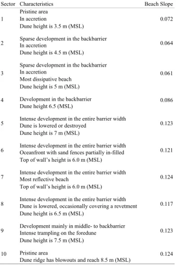
The central area of Ancão peninsula (sectors 5 to 9) has a reflective beach face, high RHIGH elevation and dense urban occupation. According to the results, from sector 5 to the east-ern area of sector 9 the beach crest can be overwashed during storms with 5, 10 and 25 years of return period. The vulner-ability of this area to extreme events is seen in Figure 7 where a storm with characteristics of a 5-year return period event strikes sector 7. Vulnerability to low storm intensity is often perceived in punctual areas, e.g. beach accesses. The steeper profile throughout the area has a corresponding effect on Table 1 - Description of the sectors within the study area and the respective calculated
beach slope.
Sector Characteristics Beach Slope
1 Pristine areaIn accretion 0.072
Dune height is 3.5 m (MSL)
2 Sparse development in the backbarrierIn accretion 0.064 Dune height is 4.5 m (MSL)
3
Sparse development in the backbarrier
0.061 In accretion
Most dissipative beach Dune height is 5 m (MSL)
4 Development in the backbarrier 0.086
Dune height 6.5 (MSL)
5 Intense development in the entire barrier widthDune is lowered or destroyed 0.123 Dune height is 7 m (MSL)
6 Intense development in the entire barrier widthOceanfront with sand fences partially in-filled 0.121 Top of wall’s height is 6.0 m (MSL)
7 Intense development in the entire barrier widthMost reflective beach 0.124 Top of wall’s height is 6.0 m (MSL)
8 Intense development in the entire barrier widthDune is lowered, occasionally covering a revetment 0.117 Dune height is 6.5 m (MSL)
9 Development mainly in middle- to backbarrierIntense trampling on the foredune 0.123 Dune height is 7.5 m (MSL)
10 Pristine area 0.124
Dune ridge has blowouts and reach 8.5 m (MSL)
Description of the sectors within the study area and the re-spective calculated beach slope
calculated runup elevations. Under surging wave conditions there is little dissipation of wave energy across the beach face, and the majority of wave energy is reflected on the slope, as observed by Stockdon et al. (2006) for other coast-al areas with intermediate to reflective characteristics. Ad-ditionally, this coastal stretch congregates the most densely occupied area along the Ria Formosa (Praia de Faro). Along the coastline, human intervention is predominantly identi-fied as shorefront buildings, foredune trampling and lowered or destroyed dunes. When present, the foredune is straighter if compared with what would occur under natural aeolian transport/construction as a result of aiding bulldozing, dune fences and revetments (particularly along sector 8). Man-made shore changes at this site altered the sediment budget and the coastal processes. The presence of coastal infrastruc-tures avoids new embryo dune development and foredune restoration (Davidson-Arnott and Fisher, 1992), which in-creases the vulnerability to overwash (Andrade, 1990; An-drade et al., 1998; Garcia, 2008).
Along the westernmost section of the study area the beach is narrow, steep and the estimated RHIGH elevation is high. Some development is present in the eastern parts but within the last sector there is minimum or absent human
intervention. From the western area of sector 9 to sector 10 the dune ridge reaches up to 10m height above mean sea level and it evidences several aeolian erosional discon-tinuities in the form of blowouts on the top of the dune. Seaward, embryonic dunes have recently been formed. This accretion morphology is a consequence of updrift beach nourishments (undertaken since 1998; Oliveira et
al., 2008), which re-established a sedimentary source to
the area. Despite the reflective beach slope, high runup el-evation and erosional features within the dune ridge, there is low or null susceptibility to overwash, as also detected by Andrade (1990) and Andrade et al. (1998).
Collision regime
The dune base along Ancão peninsula is dominated by a collision regime. As a pre-overwash phase, the collision regime is associated with rising water levels, which leads to a reduction in overall beach width and consequently in-creases the potential to extensive damage to dune ridge in the form of dune scarping. If the identified coastal areas prone to collision do not store sufficient volume of sediment in the embryo dune zone and in the foredune, overwash will potentially occur (Davidson-Arnott and Fisher, 1992).
Along sector 1, dune base has low elevation reaching less than 3m above mean sea level. It is a low-lying zone where the dune ridge is recent and low and its base can be reached by low intensity storms. From sectors 2 to 4 the dune base reaches an average of 3.5m above mean sea level. Its seaward position, as a result of the wide dune ridge and recent accumulation, makes it more vulnerable to a collision regime. The distance of the dune from the shoreline is an important factor controlling its survival be-cause of dissipation of wave energy within the beach face (Claudino-Sales et al., 2008). Sector 5 is the single seg-ment where a consistent dune area is not scarped by storms with 5 and 10 years of return period. There, the dune base has the highest elevation within the study area (5m above mean sea level). This elevation is noticeable even where the dune front was extensively substituted by buildings. The explanation for the high dune base elevation might be related to the existing shorefront restitution by placing sed-iments with bulldozers. The dune toe within sectors 6 and 7 often coincides with the base of constructions. This line is low, reaching 4m (mean sea level), and is largely under collision risk. The high vulnerability to collision regime under storms with short return periods is a consequence of the low dune base, its high exposition because of seaward location and reflective beach morphology.
From sectors 8 to 10 the dune base is the lowest regis-tered within the surveyed area. The dune toe elevation is, on average, 2.2m (mean sea level) and it has a seaward ad-vanced position. Besides the low-lying seaward dune base,
Linear estimative of peak period (TP) and storm surge (S)
for the 5, 10 and 25-year return period storm. A) Daily highest wave significant height (HS) versus peak period (TP) from June 1997 to June
2007. B) Daily highest wave significant height (HS) versus daily
hig-hest storm surge (S) from June 1997 to June 2007. FIGURE 4
the reflective beach slope and high values of RHIGH make the area extensively prone to escarpment.
dISCuSSIon of ThE dEvElopEd METhodoloGy
Method evaluation
Any hazard assessment involves a degree of uncertain-ty and this study is no exception. There is some inaccuracy in the methods used for field measurements and for
over-wash and collision hazards. These uncertainties are mostly related to the topographic survey (equipment and operator) and runup parameterisation. Differential GPS errors are re-lated to satellite constellation and atmospheric conditions, and operator-induced errors include loss of antenna’s ver-ticality and subjectivity in morphology edge interpretation (dune base and dune crest positioning). The expected er-rors in both the altimetric and planimetric point position can be, respectively, in a centimetric and decimetric scale.
RHIGH calculation is an empirical parameterisation of the setup, swash and runup set for natural beaches. The highest calculated runup (RHIGH) was occasionally underestimated since overwash was not predicted for all areas along the Ancão peninsula where overwash has been observed in the last decade. There are areas along the urbanised zone of Praia de Faro, especially within sectors 5, 6 and 7 where overwash occurs during storms with shorter return periods. These central areas of the peninsula are intensely urbanised which interferes with beach morphology, including beach width reduction and increased steepness due to rigid prom-Table 2 - Significant wave height (HS) determined by Pires (1998), and estimated wave
peak period (TP) and storm surge (S) for an event with different return period. Return Period
(years) HS(m) Tp(s) S (m)
5 5.7 11.4 0.46
10 6.4 11.9 0.54
25 7.4 12.8 0.65
Significant wave height (HS) determined by Pires (1998),
and estimated wave peak period (TP) and storm surge (S) for an event
with different return period TABLE 2
Representation of collision and overwash regimes vulnerability along the study area for 5, 10 and 25-year return period storms. DH
repre-sents the dune crest position whereas DL is dune base, which is downward from the georeferenced site for better map representation.
inent structures at the upper beach. The predictive model of Stockdon et al. (2006) is dependent on the foreshore beach slope, i.e. alongshore-variable slopes imply similar along-shore variability in swash excursion and runup elevation. Stockdon et al. (2006) compared a relative slope difference to a relative runup error when alongshore-averaged slope is used instead of a more accurate slope measure at each alongshore line. On intermediate and reflective beaches with complex foreshore topography, the alongshore vari-ability in beach steepness may result in a relative runup error equal to 51% of the variability between the meas-ured and the mean slope. Additionally, the mean difference between estimated and measured runup for the research performed by Stockdon et al. (2006) was about -18cm, in-dicating that the parameterisation tends to slightly underes-timate the elevation of runup.
In relation to the collision regime, the presence of the berm is an important controlling factor because the berm width can restrain the process. Wide berms tend to reduce the limit of the overtopping runup (Horn and Ling, 2006) hence, runup may reach the predicted DLOW height, but can-not attain the dune toe and collision regime is can-not achieved. Variations in berm width can be seen along the study area,
e.g. from sectors 2 to 4 the berm is wide, but narrows at
sectors 9 and 10. As beach face slope calculation assumes a linear profile, runup computations cannot effectively adjust to beach morphodynamic differences caused by berm vari-ability, and therefore collision regime does not completely reproduce field observations.
An important aspect of the applied method is the sea-sonal and annual dataset variation. Frequency and intensity of storm surges and W-SW energetic waves are strongly variable during the year as a response of the storm events distribution throughout the seasons. Beach morphology at
the time of survey is dependent on a number of factors such as beach seasonality, its response to the latest energetic events, beach recovery rates and sediment budget of the littoral cell. Hence the beach slope, which is a controlling factor for both overwash and collision regimes, will cause different scenarios depending on the time of year that the beach survey was undertaken.
In this study, for the computation of the key parameter RHIGH, average mean high water was considered, which yields important consequences in results. Storms with identical characteristics that act over lower or higher tidal levels will respectively induce lower or higher overwash vulnerability. According to Hofstede (1997) in a tidal coastal environment, the water level normally remains for much longer periods around the mean high water than around mean sea level. Moreover, all storms with more than 5 years of return period will last more than 2 days and eventually will act over a high tide level.
A high coincidence was noticed between obtained re-sults and overwash areas observed in last 15 years. The depicted areas in the map (Fig. 5) where collision and over-wash are likely to occur correspond to regions along Ancão peninsula where there are records of overwash and erosion caused by high wave energy events. This correspondence between the predictive method and observed occurrences confers applicability to the current approach for overwash hazard assessment.
Management application
Storms are important factors defining shoreline posi-tion and erosion history along a coastline. The identifica-tion of vulnerable coasts enables coastal mapping which is a tool for coastal management and decision making. Re-turn period is a significant concept in this perspective and setting: storm impacts with a short return period are signifi-cant because they determine the likeliness of occurrence of events. By understanding the magnitude and return period of storms it is possible to provide more accurate and com-prehensive information to help coastal managers in emer-gency planning and impact reduction of natural disasters. Overwash, with subsequent landward transport of water and sediment may cause damage or loss of properties, and ultimately lead to coastal inundation that frequently causes injury or loss of human lives.
The Ancão peninsula is the western limit of the Ria Formosa natural park, which was created in December, 9th 1987. Besides, the coastal protected area is also designated as a wetland of international recognition (Ramsar, 2008). The Ria Formosa natural park land use management plan (POPNRF), produced in 2001, considers the Ancão penin-sula as “mostly highly” vulnerable to overwash and
“high-Alongshore profile of dune crest (DHIGH) and dune base
(DLOW) heights above mean sea level and the calculated runup (RHIGH)
for different storms scenarios and for the ten sectors established along the Ancão peninsula.
ly” vulnerable to barrier breaching. The obtained results corroborate this classification on a scientific basis. Nev-ertheless, they allow a better detail and remark the areas within the Ancão peninsula which are prone to overwash and collision at a given time-scale (return period) and those expected to be safer. A management approach for the An-cão peninsula should consider these differences as well as their economic implications. Conflicts are expected con-sidering the broad range of interests and stakeholders (trad-ers, fishermen, beach us(trad-ers, tourists) and the condition of natural park. These conflicts rely especially on economic interests and conservation aspects. The increased human pressure in the system, especially along Praia de Faro, has been causing dune destruction or intense dune trampling that promotes the development of fragile sites. During high energy wave events, overwash occurs within these lowered gaps. This proves that most of the overwash areas have a human intervention causal component (Matias et
al., 2008). Overwash acts as a trigger mechanism for other
hazards, such as barrier breaching and subsequent new
in-let installation, which can impact the economical value of the region in a drastic way.
In order to obtain a final management plan for the area, mapping of vulnerable areas must be carried out and pro-tective actions must be taken. Mapping of exposed areas is strongly recommended, particularly for shorelines evolv-ing in response to natural processes and human activities. Hence, overwash vulnerability may be seen as a local strat-egy for protection and relocation of coastal communities, alteration of future urban development, emergency plan-ning and for flooding assessments.
ConCluSIonS
Setting the correct ocean’s forcing is crucial when analysing potential areas to overwash processes. Wave attributes (significant wave height and wave length), and astronomical and meteorological tides are key factors driv-ing overwash occurrence. By choosdriv-ing the best method for calculation of runup vertical scaling and tides elevation, and matching it to dunes elevation, the overwash potential is well defined. Storm impacts are not equally identified along a barrier island due to the combined effects of along-shore-variable morphology of the beach and dune relative to the intensity of the ocean’s forcing.
For the study case of Ancão peninsula, collision regime is shown as a constant hazard, whereas overwash hazard varies temporally and spatially alongshore. The shore is largely affected by a storm with 25 years return period, whereas a storm with 5 years return period promotes over-wash only at particular sites. For eastward immature and low dune crests, there is a significant connection between the overwash vulnerability and tidal inlet presence. The central area is the most vulnerable to overwash not only because of the reflective beach slope but also due to the lowering and destruction of dunes by human intervention. Ancão peninsula has physiographic characteristics prone to overwash, such as the narrow barrier, the reflective beach slope and the exposition to the energetic SW events. How-ever, the presence of a high dune ridge westward provides low vulnerability to overwash. These results highlight the importance of preserved dunes as a natural shoreline pro-tection against storm overwash.
The quantification of runup levels and coastal morpho-logy for the establishment of hazard maps provide more objective identification of areas prone to overwash when compared to methods applied in previous studies for Ancão peninsula. Moreover, hazard maps are effective tools for coastal management and planning. The developed meth-od proved to be effective on the assessment of overwash vulnerability and can therefore be widely used on similar
Examples of overwash at Praia de Faro parking place (sec-tor 7) during the 2th March 2010 storm, with conditions similar to a 5
year return return period storm. FIGURE 7
coastlines. The method’s results can be applied to set build-ing standards, land use guidelines along the coast and pro-vide information for evaluation and design of coastal inter-vention (such as fencing, nourishment and inlet relocation or stabilisation).
REfEREnCES
Andrade, C., 1990. O ambiente de barreira da Ria Formosa, Algarve-Portugal. Doctoral Thesis. Lisboa, Universidade de Lisboa, 627pp.
Andrade, C., Barata, A., Teles, M., 1998. An analysis of the vul-nerability to overwash of the Ria Formosa barrier system (Portugal) using a simple multi-attribute rating technique (SMART) approach. Barcelona, Proceedings of the 4th
Inter-national Symposium Littoral’98, EUROCOAST, 511-519. Benavente, J., Del Río, L., Gracia, F.J., Martínez-del-Pozo, J.A.,
2006. Coastal flooding hazard related to storms and coastal evolution in Valdelagrana spit (Cadiz Bay Natural Park, SW Spain). Continental Shelf Research, 26(9), 1061-1076. Claudino-Sales, V., Wang, P., Horwitz, M.H., 2008. Factors
con-trolling the survival of coastal dunes during multiple hurri-cane impacts in 2004 and 2005: Santa Rosa barrier island, Florida. Geomorphology, 95(3-4), 295-315.
Costa, C., 1994. Wind Wave Climatology of the Portuguese Coast. Lisbon (Portugal), Instituto Hidrográfico, Laboratório Nacional de Engenharia Civil, report PO-waves, final report of sub-project, 80pp.
Costa, M., Silva, R., Vitorino, J., 2001. Contribuição para o estudo do clima de agitação marítima na costa portuguesa. Sines (Portugal), Proceedings of 2as Jornadas Portuguesas de
Engenharia Costeira e Portuária, International Navigation As-sociation, Permanent International Association of Navigation Congresses, 20pp.
Davidson-Arnott, R.G.D., Fisher, J.D., 1992. Spatial and tempo-ral controls on overwash occurrence on a Great-Lakes barrier spit. Canadian Journal of Earth Sciences, 29(1), 102-117. Doornkamp, J.C., 1998. Coastal flooding, global warming and
environmental management. Journal of Environmental Man-agement, 52(4), 327-333.
Ferreira, Ó., Garcia, T., Matias, A., Taborda, R., Dias, J.A., 2006. An integrated method for the determination of set-back lines for coastal erosion hazards on sandy shores. Continental Shelf Research, 26(9), 1030-1044.
Ferreira, Ó., Ciavola, P., Armaroli, C., Balouin, Y., Benavente, J., Del Río, L., Deserti, M., Esteves, L.S., Furmanc-zyk, K., Haerens, P., Matias, A., Perini, L., Taborda, R., Terefenko, P., Trifonova, E., Trouw, K., Valchev, N., Van Dongeren, A., Van Koningsveld, M., Williams, J.J., 2009. Coastal storm risk assessment in Europe: examples from 9 study sites. Journal of Coastal Research, 56 (Special Is-sue), 1632 - 1636.
Garcia, T., 2008. Overwash vulnerability assessment based in long-term washover evolution. Application to the Ria
Formo-sa Barrier Islands System (Southern Portugal). Master Thesis. Faro, Universidade do Algarve, 71pp.
Hofstede, J.L.A., 1997. Process-response analysis for the North Frisian supratidal sands (Germany). Journal of Coastal Re-search, 13(1), 1-7.
Horn, D., Ling, L., 2006. Measurement and Modelling of Gravel Beach Groundwater Response to Wave Run-up: Effects on Beach Profile Changes. Journal of Coastal Research, 22(5), 1241-1249.
Instituto Hidrográfico, 1998. Tabela de Marés, Volume 1. Lisboa, Instituto Hidrográfico, 178pp.
Jiménez, J.A., Ciavola, P., Balouin, Y., Armaroli, C., Bosom, E., Gervais, M., 2009. Geomorphic coastal vulnerability to storms in microtidal fetch-limited environments: application to NW Mediterranean & N Adriatic Seas. Journal of Coastal Research, 56 (Special Issue), 1641-1645.
Leatherman, S.P., 1979. Migration of Assateague Island, Maryland, by inlet and over-wash processes. Geology, 7(2), 104-107. Matias, A., Ferreira, Ó., Vila-Concejo, A., Garcia, T., Dias, J.A.,
2008. Classification of washover dynamics in barrier islands. Geomorphology, 97(3-4), 655-674.
Matias, A., Ferreira, Ó., Vila-Concejo, A., Morris, B., Dias, J.A., 2009. Foreshore and hydrodynamic factors governing over-wash. Journal of Coastal Research, 56 (Special Issue), 636-640. Melo, J.S., 1989. Caracterização Hidro-Oceanográfica da Ria
Formosa. Anais do Instituto Hidrográfico, 10, 7-23.
Morton, R.A., Sallenger, A.H., 2003. Morphological impacts of extreme storms on sandy beaches and barriers. Journal of Coastal Research, 19(3), 560-573.
Oliveira, S.C., Catalão, J., Ferreira, Ó., Dias, J.M.A., 2008. Eval-uation of cliff retreat and beach nourishment in southern Por-tugal using photogrammetric techniques. Journal of Coastal Research, 24(4C), 184-193.
Pacheco, A., Vila-Concejo, A., Ferreira, Ó., Dias, J.A., 2007. Present Hydrodynamics of Ancão Inlet, 10 Years after its Re-location. New Orleans (Louisiana, USA), Proceedings of the 6th International Symposium on Coastal Engineering and
Sci-ence of Coastal Sediment Process, 1557-1570.
Pessanha, L.E., Pires, H.O., 1981. Elementos sobre o clima de agitação marítima na costa sul do Algarve. Lisbon, Instituto Nacional de Meteorologia e Geofísica, 66pp.
Pires, H.O., 1998. Preliminary Report on the wave climate at Faro - Project INDIA. Instituto de Meteorologia - Instituto Supe-rior Técnico, unpublished, 37pp.
Puertos del Estado, 2009. Datos históricos de nivel del mar. Min-isterio de Medio Ambiente, Medio Rural y Marino, Madrid. Checked: 10 February 2009. Available at:
http://www.puertos.es/es/oceanografia_y_meteorologia/ban-co_de_datos
Ramsar Convention, 2008. The List of Wetlands of International Importance. Checked: 12 February 2009. Available at http:// www.ramsar.org/sitelist.pdf
Ritchie, W., Penland, S., 1988. Rapid dune changes associated with overwash processes on the deltaic coast of South Louisi-ana. Marine Geology, 81, 97-122.
Sallenger, A.H., 2000. Storm impact scale for barrier islands. Journal of Coastal Research, 16(3), 890-895.
Stockdon, H.F., Holman, R.A., Howd, P.A., Sallenger, A.H., 2006. Empirical parameterization of setup, swash, and runup. Coastal Engineering, 53(7), 573-588.
Vila-Concejo, A., Matias, A., Pacheco, A., Ferreira, Ó., Dias, J.A., 2006. Quantification of inlet-related hazards in barrier island systems. An example from the Ria Formosa (Portugal). Continental Shelf Research, 26(9), 1045-1060.
Manuscript received october 2010; revision accepted May 2011; published online September 2011.