Bol. Ciênc. Geod., sec. Artigos, Curitiba, v. 19, no 2, p.191-207, abr-jun, 2013.
ANALYSIS OF WEB-BASED ONLINE SERVICES FOR GPS
RELATIVE AND PRECISE POINT POSITIONING
TECHNIQUES
Análise dos serviços online que empregam as técnicas dos posicionamentos GPS por ponto preciso e relativo.
TAYLAN OCALAN BAHATTIN ERDOGAN NURSU TUNALIOGLU
Yildiz Technical University Faculty of Civil Engineering Department of Geomatic Engineering
Davutpasa Campus TR-34220 Esenler-İstanbul-Turkey [email protected]; [email protected]; [email protected]
ABSTRACT
accuracy analysis was gathered from these coordinate differences and standard deviations of the obtained coordinates from different techniques and then online services were compared to each other. The results show that the position accuracies obtained by associated online services provide high accurate solutions that may be used in many engineering applications and geodetic analysis.
Keywords: GPS; Precise Point Positioning (PPP); Post-Processing; Relative Positioning; Web-Based Online Services.
RESUMO
Hoje em dia o Sistema de Posicionamento Global (GPS) tem sido efetivamente utilizado em várias aplicações de engenharia para propósitos de levantamento em diversas áreas. Serviços online de posicionamento disponíveis por diversas organizações na WEB, tem se tornado uma alternativa importante ao invés do uso de softwares científicos e comerciais de alto custo no pós-processamento e análise de dados GPS. Com o uso desses serviços, é possível obter facilmente acurácia centimétrica (cm) ou decimétrica (dm). Neste artigo, um estudo foi conduzido na rede ISKI-CORS, Istambul – Turquia, com o objetivo de analisar a acurácia obtida com os serviços mais utilizados disponíveis online ao redor do mundo (denominados OPUS, AUSPOS, SCOUT, CSRS-PPP, GAPS, APPS, magicGNSS). Esses serviços usam posicionamento relativo e posicionamento por ponto preciso (PPP) em suas soluções. Nesse estudo, as coordenadas de oito estações foram estimadas usando os serviços online e o software científico Bernese 5.0. Foram processadas 24h de dados GPS e então as diferenças nas coordenadas obtidas entre os serviços online e o Bernese foram calculadas. Nas avaliações, foi verificado que cada diferença individual foi menor que 10 mm quando empregado o serviço online de posicionamento relativo, e menor que 20 mm quando o serviço de posicionamento por ponto preciso foi usado. A análise de acurácia foi realizada a partir dessas diferenças de coordenadas e dos desvios-padrão das coordenadas obtidos pelas diferentes técnicas e então os serviços online foram comparados entre si. Os resultados mostraram que a acurácia na posição obtida pelos serviços online é alta e que estes serviços podem ser empregados em muitas aplicações de engenharia e análises geodésicas.
Palavras-Chave: GPS; Posicionamento Preciso por Pontos (PPP); Pós-Processamento; Posicionamento Relativo; Serviço Online Baseado na WEB
1. INTRODUCTION
cm-Ocalan, T. et al.
Bol. Ciênc. Geod., sec. Artigos, Curitiba, v. 19, no 2, p.191-207, abr-jun, 2013.
1 9 3 dm level and to evaluate the GPS data easily (GAO and SHEN, 2002; TSAKIRI, 2008; EL-MOWAFY, 2011).
The raw data collected from anywhere around the world by using a double frequency geodetic grade GPS receiver have been converted into Receiver Independent EXchange (RINEX) format, then they may be submitted to these web based online services and processed into them. Also, some services accept other formats, for instance Hatanaka. However, in order to estimate high accurate point coordinates; some factors such as data processing solution technique and algorithm (mathematical model) of the used service, the accuracy of the other data and products (e.g., reference station coordinates, satellite orbit and clock corrections), observation duration and quality of the collected data play significant role. While these services have several advantages for the users, they have also been useful assistants to the classical GPS surveying and processing in terms of software, hardware, equipment, personnel and logistics costs (EL-MOWAFY, 2011; TSAKIRI, 2008).
As is seen in Figure 1, the users may submit data using either to these services’ web pages or to ftp sites via internet. The results obtained by the service software are sent to the users via e-mail including typically estimated point coordinates and standard deviation values. Some of these services also send comprehensive analysis reports including graphical illustration of these results. Although many of these services are free, some of them require free membership for accessing with a user name and password. They usually use high accurate and precise International GNSS Service (IGS) data and products for computations. While IGS makes important contributions to the development and enhancement of the Global Navigation Satellite System (GNSS) standards around the world, it also holds a significant mission by collecting, archiving and presenting the high accuracy GPS/GLONASS ephemerides, satellite and station clocks, earth rotation parameters (ERP), coordinates and velocities of IGS tracking stations, atmospheric parameters to the users.
Online services present two types of solutions, which are relative solution approach and precise point positioning (PPP) solution approach. The services that are based on relative solution approach use national Continuously Operating Reference Stations (CORS) or IGS stations as reference control points. The services that are based on PPP solution approach use GPS-only or GPS+GLONASS products (such as orbit & clock corrections). Both of the solution types have been used widely and effectively for monitoring the deformations such as on landslides, structural behaviors and mining, marine applications (i.e. hydrographic surveys), geographic information systems (GIS), engineering surveys, mapping applications, as-built surveys etc. In recent years, coordinates obtained from these services have been used for geodetic analyses that require high accuracy as well.
on estimation of the point coordinates (Figure 2). For this purpose, 24-hour data in static mode of eight reference stations at ISKI-CORS Network, Istanbul-Turkey has been used. First, station coordinates have been computed to provide high-accuracy using Bernese 5.0 scientific software by relative positioning technique with network adjustment. Latter, analyses depending on the seven web-based online services have been conducted for the same data, and then the coordinate differences as reference to Bernese relative network solutions are estimated for each web-based online service. An accuracy analyses for each station and web-based online service are carried out according to comparing these coordinate differences and the standard deviations of the coordinates obtained from online services.
Figure 1 - The main working illustration of web-based online services.
2. WEB-BASED ONLINE GPS DATA PROCESSING SERVICES
2.1 Services using relative solution approach
Traditionally, most of the professional GPS users have used relative positioning technique to provide high accuracy. However, this technique has some disadvantages related to PPP technique, such that minimum two or more GPS receivers should be used and the true coordinates of the reference stations should be known. Addition to this, increase of the distance between reference station (base) and rover station has reduced the position accuracy (ABD-ELAZEEM et al., 2011).
Ocalan, T. et al.
Bol. Ciênc. Geod., sec. Artigos, Curitiba, v. 19, no 2, p.191-207, abr-jun, 2013.
1 9 5 RINEX data belonging to these stations for many surveying applications. Furthermore, web-based online services using relative solution approach, which present free computation tasks, have been constructed through these stations and networks. Services using relative solution approach estimate the point coordinates with double-difference technique by using data from either global IGS network or national CORS networks. The formulation of the double-difference technique for phase measurements can be given as follows:
Δφ t = Δr(t, t-τ) + Δds(t-τ) - Δdiono + Δdtropo+ ΔλΝ + Δε(φ) (1)
where;
Δ is the double difference operator at the time of receiving data
φ is the phase measurement (t) is the time of receiving data (t-τ)is the satellite time
τ is the travel time from the satellite to the receiver r(t, t-τ) is the true geometric range
ds is the orbital prediction error
diono and dtropo are the ionospheric and tropospheric errors, respectively
λ is the wavelength
Ν is the integer phase ambiguity
ε is the noise components
In Table 1, full names and organizations of the OPUS, AUSPOS and SCOUT services, which are the most commonly known services and have been using the relative solution approach, is given. These services also include the scientific software (process engine), which provides long base solutions in global networks. Owing to the fact that providing high accuracies at mm level, these services have been also used commonly for geodetic analyses in recent years.
AUSPOS uses completely IGS Network data and products (final, rapid, ultra-rapid depending on availability precise orbit parameters, Earth orientation parameters and coordinate solution IGS products are used) for data processing. Users may submit RINEX data in static mode either using “upload” or “ftp”. Seven different RINEX data files with antenna types and heights may be submitted to the system simultaneously. However, some restrictions may appear depending on the length of GPS data. System processor uses Bernese software for all computations. The coordinates of points are provided in Geocentric Datum of Australia 1994 (GDA94) and ITRF (http://www-b.ga.gov.au/bin/gps.pl).
SCOUT requires minimum 1-hour observation data for processing and uses GAMIT scientific processing software. The RINEX data are submitted via ftp access. Analyses are performed taking account the nearest IGS reference stations listed by SOPAC. In processing, minimum three reference stations are required. However, the service permits the user to choose up to four reference stations as well. The coordinates are referred to ITRF2005 and World Geodetic System 1984 (WGS84) with observation epochs on analysis solution report (http://sopac.ucsd.edu/cgi-bin/SCOUT.cgi).
Table 1 - Online services using relative solution approach. Service
Short Name
Service
Long Name Organizations
Web Pages (May, 2012)
OPUS
Online Positioning User Service
NOAA-National Geodetic Survey (NGS)
http://www.ngs.noaa.gov/OPUS/
AUSPOS
Online GPS Processing
Service
Geoscience Australia
http://www-b.ga.gov.au/bin/gps.pl
SCOUT
Scripps Coordinate Update Tool
Scripps Orbit and Permanent
Array Center (SOPAC)
http://sopac.ucsd.edu/cgi-bin/SCOUT.cgi
2.2 Services using PPP solution approach
According to the developments on satellite geodesy, precise satellite ephemerides and clock products are obtained by organizations such as IGS, Jet Propulsion Laboratory (JPL), Natural Resources Canada (NRCan) etc., and these are presented to the users.
Ocalan, T. et al.
Bol. Ciênc. Geod., sec. Artigos, Curitiba, v. 19, no 2, p.191-207, abr-jun, 2013.
1 9 7 ionospheric-free both carrier-phase (Ф) and code pseudorange (P) observations collected by dual-frequency receiver for data processing. This technique provides precise positioning by using precise ephemeris and clock products provided by IGS and other organizations and by considering other corrections such as satellite effects (satellite antenna offsets and phase wind-up), site displacement effect (solid earth tides, polar tides, ocean loading, earth rotation parameters) and compatibility considerations (products formats, reference frames, receiver antenna phase center offsets, modeling/observation conventions) (ZUMBERGE et al., 1997; KOUBA and HÉROUX, 2001; KOUBA, 2009; ABD-ELAZEEM et al., 2011).
As stated in both Zumberge at al.(1997) and Kouba and Heroux (2001), the ionospheric-free combinations of dual-frequency GPS pseudorange (P) and carrier-phase observations (Ф) are related to the user position, clock, troposphere and ambiguity parameters according to the following simplified observation equations:
P = ρ + C(dT- dt) + Tr + εP (2)
Ф = ρ + C(dT-dt) + Tr + Nλ + εФ (3)
where;
P is the ionosphere-free combination of P1 and P2 pseudoranges (P3)=(2.546P1-1.546P2)
Ф is the ionosphere-free combination of L1 and L2 carrier-phases (L3)=(2.546 λ1Ф1-1.546 λ2Ф2)
ρ is the geometrical range computed as a function of satellite and station coordinates C is the vacuum speed of light
dT is the station receiver clock offset from the GPS time dt is the satellite clock offset from the GPS time
Tr is the signal path delay due to the neutral-atmosphere (primarily the troposphere)
N is the non-integer ambiguity of the carrier-phase ionosphere-free combination
λ1, λ2, λ are the of the carrier-phases L1, L2 and L3-combined (10.7 cm)
wavelengths, respectively
εP, εФ are the relevant measurement noise components, including multipath,
observable-dependent receiver bias and observable-dependent satellite bias and other effects.
The obtainable position accuracy depends on the used mathematical model on PPP software, the quality and content of the observation file. In table 2, the full names and organizations of the most commonly known PPP services can be seen. In table 3, software type of PPP services for static mode can be seen.
reports. This service has actively processed GLONASS data from 4 October 2011 and accepted user provided ocean tidal loading (OTL) correction files from 14 February 2012. In order to facilitate freely from this service, users should take user name and password from the site for membership (www.geod.nrcan.gc.ca/ online_data_e.php).
Table 2 - Online services using PPP solution approach. Service
Short Name
Service
Long Name Organizations
Web Pages (May, 2012)
CSRS-PPP
Canadian Spatial Reference
System-Precise Point
Positioning
Natural Resources
Canada (NRCan)
http://www.geod.nrcan.gc.ca/ online_data_e.php
GAPS
GPS Analysis and Positioning
Software
University of New Brunswick
(UNB)
http://gaps.gge.unb.ca/
APPS
Automatic Precise Positioning
Service
NASA - Jet Propulsion Laboratory
(JPL)
http://apps.gdgps.net/
magicGNSS
magicPPP - Precise Point
Positioning Solution
GMV Innovating
Solutions
http://magicgnss.gmv.com/ppp
Table 3 - Software type of PPP services for static positioning mode (http://gge.unb.ca/Resources/PPP/OnlinePPPs.html).
CSRS-PPP GAPS APPS magicGNSS
All epochs Forward only
5-min epochs Forward only
5-min epochs Smoothed
All epochs Batch solution
O t t f b p k T G a S c 3 e l e T e l e C Y
Ocalan, T. et al. the services se the industrial
magicGN firm. By regi based worksp processes the kinematic mo There is also GPS+GLONA analyze repor System 1989 com/ppp). 3. EXPERIM The resu examined in length and se estimation suc This study ai especially usin
For this located at Ista experimental CORS station YALI on Dec
Bol. C end the solutio
users (http://g NSS/PPP (ma stering to the pace or send dual-frequen odes, by using selection oppo ASS RINEX d rts and graph 9 (ETRS89)
MENTAL WO ults of proces many studies elected softwa ch as mm or ims to test th ng relative an
Figure
purpose, eig anbul, Turkey study was co ns namely, BE
cember 31, 2
iênc. Geod., sec. ons through e gaps.gge.unb.c agicPPP) is a e service, user them via e-m ncy observatio g rapid and fin ortunity for u data. The resu hics through and ITRF
ORK
ssing the GPS s, and the eff are have been cm level acc he accuracy a d PPP solutio
e 2 - ISKI-CO
ght reference y (see in Figu onducted. 24-h EYK, KCEK 2011 (epoch 2
Artigos, Curitiba e-mail. Howev ca/; http://app
free software rs either uplo mail to magi on files, whic nal GPS orbit
sers to proces ults are sent b e-mail in Eu 2008 coordi
S data collect fects of the o n investigated curacies (SOY analysis of th n approaches.
ORS Network
stations from ure 2) were s hour GPS dat , PALA, SIL 2011.9986) w
a, v. 19, no 2, p.19
ver, APPS furn s.gdgps.net/). e developed b oad raw data [email protected] ch are collect ts and clocks ss GPS-only, G back to the us uropean Terre inates (http:/
ted in static observation d for high acc YCAN and O he web-based .
Stations.
m ISKI-COR selected as te ta in static m LE, SLVR, TE were selected
91-207, abr-jun, 2 nishes with ftp
by Spanish GM files in the w om. The serv ted in static
products of I GLONASS-on sers with deta
estrial Refere //magicgnss.gm
mode have b duration, base curacy coordin OCALAN, 20
d online servi
RS local netw est points and mode collected ERK, TUZL for the accur
analysis. The data-sampling interval was 30 second. The aim of using long period observation data is to eliminate the errors that may occur depending on short period observation durations.
Firstly, point coordinates have been estimated for high accuracy by using Bernese 5.0 scientific GPS data processing software. In the evaluations, ANKR, ISTA, NICO and ZECK stations from IGS network have been taken as reference stations. Here, all computed coordinates were based on the IGS realization of ITRF2008 reference frame epoch 2011.9986. In the evaluation process, precise IGS products (final GPS satellite ephemerides and earth rotation parameters) have been used. Using the correct phase centre offsets becomes very important when different antenna types are used in a survey. In order to correct receiver antenna phase center offset, the related files that can be downloaded at the GPS Antenna Calibration page of the US National Geodetic Survey were used at the processing. In the first processing step, single point positioning has been performed by using ionosphere-free (L3) observable, the receiver clock errors have been eliminated, and then coordinates of the reference stations in the network have been pre-determined. Cycle slips and outliers have been controlled by using triple differences. After this process, the outliers have been removed. If the carrier phase cycle slips are the case, then they have been fixed otherwise ambiguity parameters have been computed and added to them. Later, ambiguity parameters have been solved. In order to solve the ambiguity parameters, Quasi Ionosphere Free (QIF) strategy has been applied. The Saastamoinen model was chosen for computing tropospheric delay at each station, and they have been eliminated by determining zenith delay parameter computed in constant time intervals. Consequently, precise cartesian coordinates (X,Y,Z) of eight stations in ITRF2008 reference frame and epoch 2011.9986 have been computed and assigned as reference coordinates to control with web-based online services results for comparative purposes.
The data belonging to the eight stations have been submitted on 7-8 February 2012 separately to the seven online services, some of which are using relative solution approach namely OPUS, AUSPOS, SCOUT and, some of which are using PPP solution approach namely CSRS-PPP, GAPS, APPS, magicGNSS. Therefore, final products (IGS/JPL) have been used in processing with online services. The solution reports have been received via e-mail, then point coordinates and standard deviations have been obtained separately from each service.
4. RESULTS AND ANALYSIS
Ocalan, T. et al.
Bol. Ciênc. Geod., sec. Artigos, Curitiba, v. 19, no 2, p.191-207, abr-jun, 2013.
2 0 1 coordinates (X, Y and Z) obtained from SCOUT service were range between 2.3 mm and 7.2 mm. Moreover, the standard deviations of the coordinates (X, Y and Z) obtained from AUSPOS service were less than 1 mm. OPUS and SCOUT services were used 3 reference points for the solutions, but AUSPOS service were used 11 or 12 reference points. Therefore, the standard deviations were less than other relative service.
It is also provided as the standard deviations of the coordinates are small for the PPP solution services, too. The standard deviations of the coordinates (X, Y and Z) obtained from CSRS-PPP service were range between 2 mm and 10 mm. The standard deviations of the coordinates (X, Y and Z) obtained from GAPS service were changed between 4.4 mm and 5.8 mm. The standard deviations of the coordinates (X, Y and Z) obtained from APPS service were less than 2 mm and APPS service has the minimum standard deviations for the obtained coordinates. MagicGNSS service provides only the points’ coordinates, the related standard deviations are not added to the report files.
The standard deviations of the coordinates obtained from different online services are given in Table 4.
Table 4. The standard deviations of the coordinates (mm) Station
ID
Bernese 5.0 OPUS AUSPOS SCOUT SX SY SZ SX SY SZ SX SY SZ SX SY SZ
BEYK 0.4 0.2 0.3 4.0 5.0 3.0 < 1 < 1 1.0 2.7 4.7 6.4 KCEK 0.3 0.2 0.3 15.0 8.0 8.0 < 1 < 1 1.0 2.9 5.0 6.7 PALA 0.3 0.2 0.3 5.0 8.0 3.0 < 1 < 1 1.0 2.5 4.6 6.0 SILE 0.3 0.2 0.3 4.0 6.0 3.0 < 1 < 1 1.0 3.0 5.3 7.2 SLVR 0.3 0.2 0.3 8.0 8.0 7.0 < 1 < 1 1.0 2.5 4.7 6.1 TERK 0.3 0.2 0.3 2.0 4.0 4.0 < 1 < 1 1.0 2.9 5.0 6.6 TUZL 0.3 0.2 0.3 8.0 11.0 7.0 < 1 < 1 1.0 2.3 4.4 5.8 YALI 0.3 0.2 0.3 7.0 11.0 8.0 < 1 < 1 1.0 2.7 4.9 6.3 Station
ID
CSRS-PPP GAPS APPS
SX SY SZ SX SY SZ SX SY SZ
BEYK 2.0 4.0 10.0 5.8 4.5 4.9 1.9 1.5 1.5 KCEK 2.0 4.0 10.0 5.5 4.5 4.8 1.6 1.4 1.4 PALA 2.0 4.0 10.0 5.4 4.4 4.7 15.0 1.3 1.3 SILE 2.0 5.0 10.0 5.4 4.5 4.8 1.6 1.4 1.4 SLVR 2.0 4.0 10.0 5.4 4.4 4.7 1.5 1.3 1.3 TERK 2.0 4.0 10.0 5.5 4.4 4.8 1.6 1.4 1.4 TUZL 2.0 5.0 10.0 5.3 4.4 4.7 1.5 1.3 1.3 YALI 2.0 5.0 10.0 5.4 4.4 4.8 1.6 1.4 1.4
technique and web-based online service solutions have been taken into consideration. The Bernese 5.0 points' solutions are taken as true point coordinates, and used as references. For differencing purpose, Eq.4 is used.
Difference (Δ) = Bernese 5.0 solution – Online service solution (4)
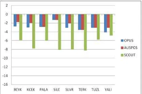
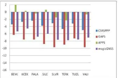
The graphical representation of computed differences in mm depending on Eq.4 can be seen in Figures 3, 4, 5, 6, 7 and 8. Moreover, the means of the absolute differences for all services are given in Table 5.
Table 5. The means of the absolute differences for all services.
Service
OPUS (ΔX) (ΔY) (ΔZ)
AUSPOS (ΔX) (ΔY) (ΔZ)
SCOUT (ΔX) (ΔY) (ΔZ)
CSRS PPP (ΔX) (ΔY) (ΔZ)
GAPS (ΔX) (ΔY) (ΔZ)
APPS (ΔX) (ΔY) (ΔZ)
MagicGNSS (ΔX) (ΔY) (ΔZ) Means of absolute differences (mm) 3.2 2.2 3.0 0.8 0.9 2.5 6.4 3.4 6.8 5.9 3.5 7.6 3.6 8.3 14.0 5.0 1.0 6.5 11.8 6.6 9.3
For the relative positioning solutions, AUSPOS service has more reliable results than the other services. The means of the absolute differences for AUSPOS are the minimum values among all differences. It has max absolute differences for
ΔX, ΔY and ΔZ as 1.6 mm (TERK), 1.7 mm (TERK) and 3.6 mm (TERK), respectively. OPUS service has max absolute differences for ΔX, ΔY and ΔZ as 6.4 mm (KCEK), 4.0 mm (YALI) and 4.1 mm (YALI), respectively. SCOUT service has max differences among all relative positioning services. It has 8.8 mm (SLVR), 5.3 mm (SILE) and 8.2 mm (TERK) for ΔX, ΔY and ΔZ, respectively.
For the precise point positioning, APPS service has the more reliable results than the other services. Although GAPS service has differences that are approximately equal to APPS service for ΔX, the differences for ΔY and ΔZ are bigger than the APPS service. APPS service has max absolute differences for ΔX,
Ocalan, T. et al.
Bol. Ciênc. Geod., sec. Artigos, Curitiba, v. 19, no 2, p.191-207, abr-jun, 2013.
2 0 3
Figure 3 – The differences of the estimated coordinates for relative positioning solution (ΔX) (mm).
Figure 4 – The differences of the estimated coordinates for relative positioning solution (ΔY) (mm).
‐16
‐14
‐12
‐10
‐8
‐6
‐4
‐2 0 2
BEYK KCEK PALA SILE SLVR TERK TUZL YALI
OPUS
AUSPOS
Figure 5 – The differences of the estimated coordinates for relative positioning solution (ΔZ) (mm).
Ocalan, T. et al.
Bol. Ciênc. Geod., sec. Artigos, Curitiba, v. 19, no 2, p.191-207, abr-jun, 2013.
2 0 5 Figure 7 – The differences of the estimated coordinates for precise point
positioning solution (ΔY) (mm).
5. CONCLUSION
In recent years, web-based online services for GPS data processing have become widely used. These services, which process the GPS data freely through internet and require any prior software knowledge, provide significant contributions to the users in terms of software, hardware, equipment, personnel and logistics costs. New developments over algorithms of GPS point positioning and accuracy enhancement of the products provided by organizations (IGS etc.) increase the number and the quality of these services.
In this study, a test study was conducted by considering all web-based online services, which are used frequently and widely in the world. For this purpose, eight different stations data belong to a local CORS network were determined by using three relative solution approach services and four PPP solution approach services. 24-hour GPS data was considered. The true station coordinates were computed by Bernese 5.0 software using network adjustment. The accuracies provided by services were obtained by comparing online service coordinates with true station coordinates. According to the results, the relative positioning services has more reliable results than the precise point positioning service as considering the differences between Bernese network solution (true station coordinates) and web based online solution. Also, the results of the AUSPOS service are nearest to Bernese network solution. APPS has the more reliable results among the other PPP services. According to obtained results web based online services are able to produce final coordinates at the accuracy of a few millimeters to centimeters and they can be applied for geodetic application and analyses.
ACKNOWLEDGEMENT
We would like to thank the Istanbul Water and Sewerage Administration (ISKI) for data and International GNSS Service (IGS) for data and products supports, and to organizations, which present web-based online services (OPUS, AUSPOS, SCOUT, CSRS-PPP, GAPS, APPS, magicGNSS).
REFERENCES
ABD-ELAZEEM, M.; FARAH, A.; FARRAG F.A. Assessment study of using online (CSRS) GPS-PPP Service for mapping applications in Egypt. Journal of Geodetic Science, v.1, n.3, p. 233-239, 2011.
Automatic Precise Positioning Service (APPS) web page. URL: http://apps. gdgps.net/ (14.05.2012).
Canadian Spatial Reference System-Presice Point Positioning (CSRS-PPP) web page. URL:http://www.geod.nrcan.gc.ca/online_data_e.php (14.05.2012). EL-MOWAFY, A. Analysis of web-based GNSS post-processing services for static
Ocalan, T. et al.
Bol. Ciênc. Geod., sec. Artigos, Curitiba, v. 19, no 2, p.191-207, abr-jun, 2013.
2 0 7 GAO, Y and SHEN, X. A New Method for Carrier Phase Based Precise Point
Positioning. Navigation, Journal of the Institute of Navigation, Vol. 49, No. 2, 2002.
GPS Analysis and Positioning Software (GAPS) web page.URL: http://gaps. gge.unb.ca/ (14.05.2012).
KOUBA, J.; HÉROUX, P. Precise Point Positioning using IGS orbit and clock products. GPS Solutions, v. 5, n. 2, p. 12-28, 2001.
KOUBA, J. A guide to using International GNSS Service (IGS) products, May 2009, http://igscb.jpl.nasa.gov/ components/usage.html.
magicPPP-Precise Point Positioning Solution (magicGNSS) web page. URL: http://magicgnss.gmv.com/ppp, 14.05.2012.
Online GPS Processing Service (AUSPOS) web page. URL: http://www-b.ga.gov.au/bin/gps.pl (14.05.2012).
Online Positioning User Service (OPUS) web page. URL: http://www.ngs.noaa. gov/OPUS/ (14.05.2012).
Scripps Coordinate Update Tool (SCOUT) web page. URL:http://sopac.ucsd. edu/cgi-bin/SCOUT.cgi, 14.05.2012.
SOYCAN, M.; OCALAN, T. A regression study on relative GPS accuracy for different variables. Survey Review,v. 43, n. 320, p. 137-149, 2011.
The Precise Point Positioning Software Centre web page. URL: http:// gge.unb.ca/Resources/PPP/OnlinePPPs.html (14.05.2012).
TSAKIRI, M. GPS Processing Using Online Services. ASCE Journal of Surveying Engineering, v. 134, n. 4, p. 115-125, 2008.
ZUMBERGE, J.F.; HEFLIN, M.B.; JEFFERSON, D.C.; WATKINS, M.M.; WEBB, F.H. Precise Point Positioning for the efficient and robust analysis of GPS data from large networks. Journal of Geophysical Research, v. 102, n. B3, p. 5005-5017, 1997.