Advances in Geosciences, 5, 105–111, 2005 SRef-ID: 1680-7359/adgeo/2005-5-105 European Geosciences Union
© 2005 Author(s). This work is licensed under a Creative Commons License.
Advances in
Geosciences
Conceptualization and implementation of a regional groundwater
model for the Neckar catchment in the framework of an integrated
regional model
J. Jagelke and R. Barthel
Institute of Hydraulic Engineering, Universitaet Stuttgart, Germany
Received: 7 January 2005 – Revised: 1 August 2005 – Accepted: 1 September 2005 – Published: 16 December 2005
Abstract.Joint modelling of surface and subsurface systems is necessary to assess the quantity and quality of the water resources in a watershed. Therefore, it is widely applied in integrated regional models.
The presented study deals with groundwater modelling within the framework of the integrated regional model MOS-DEW, which is being developed for the Neckar catchment in Germany with the objective of contributing to the imple-mentation of the EU Water Framework Directive (EU-WFD) (www.rivertwin.org). The groundwater model aims at ob-taining a better understanding of the groundwater recharge processes and at evaluating the groundwater resources on wa-tershed scale. In this paper the developed coupling method is described. Furthermore the groundwater model construction based on the available database and first calibration results are presented.
1 Introduction
The objective of the EU-Research project RIVERTWIN is the development of an integrated regional model MOSDEW for the strategic planning of water resources in twinned river basins under contrasting ecological, social and economic conditions. The basins under examination are the Neckar catchment in Germany, the Ou´em´e basin in B´enin and the Chirchik basin in Uzbekistan. Due to the higher data density in Germany, the integrated model is first being developed for the Neckar catchment. Upon completion, it will afterwards be adjusted to the remaining two catchments, for which only sparse data is available. Therefore, only the Neckar catch-ment is discussed in this paper.
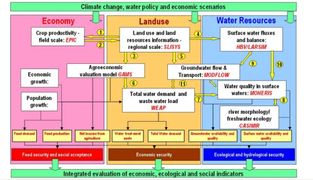
The concept of the integrated model is shown in Fig. 1. The model consists of eight sub-models which evaluate the current status of and simulate future development within the three fields economy, land use and water resources. The
sub-Correspondence to:J. Jagelke
models interact with each other through the exchange of de-fined parameters (see Fig. 1).
Figure 2 shows the coupling principle for water resources modelling with regard to the water quantity. The ground-water model interacts with the rainfall-runoff model HBV and with the water-demand model WEAP. The groundwater model receives the spatially and temporally highly differen-tiated groundwater recharge from the HBV-model and wa-ter extractions on municipality scale from the WEAP-model. Using this data as the boundary conditions, the groundwater model simulates the base flow and provides it to the flood routing module of the HBV-model. The coupled solution of the models – including calibration and validation – is based on the sequential solving of equations for the common pa-rameters until the difference between succeeding solutions of the common parameter becomes less than a predefined toler-ance. Details regarding the functioning of the HBV-model and on the calibration of the groundwater recharge are given in G¨otzinger and B´ardossy (2005).
2 Neckar catchment
The Neckar catchment is located in the state of Baden-W¨urttemberg in the southwestern part of Germany. It cov-ers an area of almost 14 000 km2with a population of 5 mil-lion people. The terrain elevation varies between 89.9 and 974.6 m above sea level.
106 J. Jagelke and R. Barthel: Conceptualization and implementation of a regional groundwater model
Fig. 1.Schematized concept of the integrated model MOSDEW showing the single sub-models and the corresponding exchange parameters.
Fig. 2.Coupled water resource model.
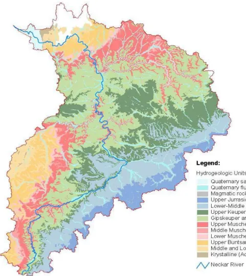
The hydrogeological situation is dominated by the occur-rence of fractured and karst formations. Ten quasi-horizontal hydrogeological units can be distinguished which comprise eight main freshwater aquifers. Figure 3 shows the outcrop of the hydrogeological units. The layers dip slightly to the southeast.
Most of the hydrogeological units are composed of sand-stone or limesand-stone. Formations rich in rock salt and gypsum occur at distinct positions in the hydro-stratigraphic sequence in regionally varying thickness. The hydraulic properties of the fractured or karst aquifers vary strongly in space. The aquifers are mostly confined. The occurrence of saline and
karstic formations makes the assessment of the groundwater resources in the Neckar catchment a very challenging task. Both horizontal as well as vertical flows have to be consid-ered in order to evaluate the available amount of groundwater of good quality in space and time.
3 Groundwater model
3.1 Model selection
In integrated regional models, hydrological models are usu-ally applied. Distributed models are rarely used on the re-gional scale due to the required data density for parameteri-sation and to their high computational demand (Wolf et al., 2004). Yet simple hydrological models are unable to simu-late fluctuations of the piezometric heads, flow direction and velocity, cross formational flow, etc. Therefore a distributed model was chosen to reproduce the complex groundwater system. In view of the complex hydrogeological situation, it was decided to construct a three-dimensional model con-sisting of ten layers.
J. Jagelke and R. Barthel: Conceptualization and implementation of a regional groundwater model 107
Fig. 3.Hydrogeological units in the Neckar basin (LGRB, 2000).
the simulation of the leakage between adjacent hydrogeolog-ical units and it can reproduce flowpaths in all three spatial directions. Both features can help in quantifying the fresh-water resources. MODFLOW offers the additional benefits of being easy to explain and free of cost, rendering the antic-ipated transfer of modelling knowledge to B´enin and Uzbek-istan feasible.
3.2 Model discretisation
The discretisation of the model domain is a fundamental task because it directly affects the results of the numerical model. In general the finer the discretisation, the more detailed and precise is the simulated groundwater flow, provided that data is available in sufficient quantity and quality. Despite the rapid development of processors in recent years, computing power remains a constraint for the discretisation of regional groundwater models. Far more important than the computa-tion time itself is the time and effort necessary to set up and evaluate model runs for testing, calibrating and validating.
Since the project RIVERTWIN is carried out with sup-port of the environmental authorities of the State of
Baden-W¨urttemberg, it was decided to utilise the modelling grid used by the authorities. This modelling grid is based on a 1 km2-raster which is aligned to north. The resulting number of modelling cells is 14 000 per layer, which still assures a convenient computing time. Furthermore the 1 km2-grid is coarse enough to treat the fractured and karstic aquifers as continuous media. Under these conditions, the fractures can be assumed to be small compared to the extent of the model cell. Thus the application of MODFLOW, which is based on the Darcy equation, is justified.
108 J. Jagelke and R. Barthel: Conceptualization and implementation of a regional groundwater model
4 Database
In order to model a groundwater system, a conceptual hy-drogeological model representing the groundwater flow sys-tem must be constructed using all available data, i.e. maps, profiles, and pumping tests. When establishing a conceptual model, the hydrogeological conditions have to be simplified so that they can be implemented in the numerical ground-water model. At the same time this “simplified groundground-water system” should still represent the natural conditions in a rea-sonable way with respect to the applicability of the model results.
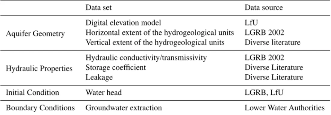
The following table gives an overview on the components of the conceptual model and the underlying data, respec-tively. Due to insufficient data availability, the datasets stor-age coefficients, leakstor-age, as well as the hydraulic conduc-tivity have to be at least partly assumed or estimated. In the following paragraph the components are introduced in detail. 4.1 Aquifer geometry
Based on all available data, a 3-D-hydrogeological model was established. This first conceptual model was a rela-tively complex representation of the hydrogeological situa-tion, which had to be iteratively simplified and fitted to the modelling grid in order to be implemented in MODFLOW.
The hydrogeological model is based on the Hydrogelog-ical Units (LGRB, 2002), a compilation of hydrogeologi-cal data produced by the State Institute for Geology, Min-ing and Raw Materials (Landesanstalt f¨ur Geologie, Berg-bau und Rohstoffe, LGRB) on behalf of the Ministry of the Environment and Communication of the State of Baden-W¨urttemberg (UVM). Within the scope of this compilation, the outcrops of the seven main aquifers which occur in the state of Baden-W¨urttemberg were delineated and the hydro-geological properties of the aquifers were characterized. The Hydrogeological Units correspond to the main water bodies according to the Water Framework Directive (WFD) of the European Union (EU).
In order to extend the 2-D-distribution of the hydrogeolog-ical units at the surface supplied by the LGRB downward, ad-ditional information on the stratigraphical sequence has been collected in the course of the given project. The following sources were used:
1. digital contour maps of stratigraphical boundaries con-tained in the Hydrogeological Units,
2. analogue structural maps included in the Geological Map for the State of Baden-W¨urttemberg on the scale of 1:25 000,
3. analogue structural maps found in literature.
All available analogue structural maps were collected, scanned, and georeferenced and the elevations of contour and structure lines (i.e. fractures) were digitized. Different maps containing the same elevation information were com-piled and contour lines crossing map edges were adjusted.
Since the elevation map compilation contains interruptions, an interpolation was necessary in order to obtain a consistent elevation map of the tops and the bottoms of all modelled hy-drogeological layers covering the entire Neckar basin. The interpolation method used was the deterministic fast Inverse Distance Weighted method.
In order to implement the layered structures in the MOD-FLOW numerical model, the elevation values were aggre-gated for each cell of the modelling grid, whereby the el-evations were adjusted starting from the top (the elevation model), so that the layers do not intersect and a minimum layer thickness of 5 m is maintained.
4.2 Hydraulic properties
The available hydraulic properties of the eight model layers are described in the Hydrogeological Units (LGRB, 2002). In this framework, more than 2000 available pumping tests carried out in the state of Baden-W¨urttemberg were statisti-cally evaluated. The statistical results give an overview of the magnitude and the variation of the transmissivities and the hydraulic conductivities in the different hydrogeological units (LGRB, 2002).
Despite the fact that this is the largest available dataset of hydraulic properties, it provides only general information on the hydrogeological units and does not reveal the infor-mation needed to assign parameters to each of the 14 000 modelling cells. Therefore, the effective parameters are to be estimated using an inverse modelling approach based on the Gauss-Marquardt-Levenberg method (Sect. 5).
4.3 Boundary conditions
In a large river catchment such as the Neckar basin, it can be assumed that the surface watershed has the same extent as the subsurface groundwater catchment. Therefore no-flow boundaries were assigned all around the model domain. Sev-eral previously carried out tracer tests support this assump-tion.
J. Jagelke and R. Barthel: Conceptualization and implementation of a regional groundwater model 109
Table 1.Conceptual model components and the data basis.
Data set Data source
Aquifer Geometry
Digital elevation model LfU
Horizontal extent of the hydrogeological units LGRB 2002 Vertical extent of the hydrogeological units Diverse literature
Hydraulic Properties
Hydraulic conductivity/transmissivity LGRB 2002 Storage coefficient Diverse Literature
Leakage Diverse Literature
Initial Condition Water head LGRB, LfU
Boundary Conditions Groundwater extraction Lower Water Authorities
the data is available in digital format. The greatest inconve-nience is that some districts have no geographical informa-tion for the extracinforma-tion sites.
All 28 Lower Water Authorities in the Neckar catchment have agreed to make the extraction data available. Neverthe-less data processing is very time-consuming because some data has to be digitized or linked to the extraction sites. 4.4 Initial conditions
In order to determine the initial groundwater heads to be used as starting conditions in the flow model, groundwater level data for the entire Neckar catchment is needed. The State Institute for Environmental Protection Baden-W¨urttemberg (LfU) delivered a groundwater database containing time se-ries composed of groundwater levels measured weekly from 1980 up to 2003 at 194 measuring points. Furthermore the State Geological Survey (LGRB) supplied 800 individual groundwater measurements carried out in connection with pumping tests. Additionally groundwater level data from the area surrounding of the Neckar catchment was supplied by the LfU.
The groundwater measurement points are irregularly dis-tributed. Many wells are situated in the Quaternary river sed-iments – especially in the Rhine Valley – or in the deeper fractured aquifers along the main rivers. Because data is very sparse between the main river valleys, methods other than simple interpolation had to be applied in order to con-struct the piezometric surface. Therefore, a kriging interpo-lation was carried out using all available groundwater mea-surements as well as the following additional data:
1. Surface elevation along rivers of first and second stream order which was assumed to be equivalent to the piezo-metric surface,
2. Estimated groundwater elevation along the mountain ranges between the main river valleys based on a corre-lation between groundwater measurements and the sur-face elevation.
Figure 4 shows the interpolated groundwater table.
5 Model calibration
The model calibration was first carried out for steady-state flow conditions. Thereby the hydraulic conductivity of pre-assigned geological zones was adjusted applying the Gauss-Marquardt-Levenberg algorithm such that the weighted sum of the squared differences between the measured and the model-generated groundwater levels is minimized. The fol-lowing figures show the first calibration results.
Both the groundwater table in Fig. 4 as well as the statis-tics in Fig. 5 display a satisfactory calibration result with a plausible groundwater flow field and a relatively small er-ror: the root mean squared error is 35 m and the correlation coefficient is 0.97. This is a good basis for the transient cali-bration.
6 Discussion
110 J. Jagelke and R. Barthel: Conceptualization and implementation of a regional groundwater model
84 - 175 175 - 266 266 - 356 356 - 447 447 - 538 538 - 628 628 - 719 719 - 810 810 - 900 Grundwasserstand [m ü. NN]
Fig. 4.Interpolated groundwater table (left) and model-generated groundwater table from the steady-state calibration (right).
Fig. 5.Comparison of measured and model-generated groundwater levels.
applicability have to be considered carefully. To find the right balance is the critical task. In the present study the following aspects concerning the data situation were found to be deci-sive. Whereas in some cases they reflect at least partly the situation in Germany, most aspects can be generalized:
The data compilation in regional groundwater modelling is very time consuming because many competent authorities exist on this spatial level and their responsibilities often over-lap. Therefore, data requests have to be addressed to several offices. Because of coexisting responsibilities, the collected data is often not consistent and the data processing therefore laborious.
Also problematic are a) the total amount of available data, which is generally small and b) the irregular distribution of the available data. The model strategy and discretisation has
to find a balance between those areas where data is very scarce and those areas where the data density is very high. To achieve globally reliable and applicable results means finding compromises for both cases.
In spite of the very good data situation in the Neckar catch-ment, there are still significant gaps which must be bridged by interpolation or assumptions based in part on educated guesses. The need to interpolate data is not exceptional in groundwater modelling, but in a regional model the results of interpolation are even less reliable because of the large dis-tances between observation points. Often the most basic re-quirements needed to interpolate meaningfully between two data points are not fulfilled. On the other hand, for some pa-rameters, interpolation is the only way to parameterize the large number of cells.
Whereas interpolation and the subsequent uncertainty are common for less investigated areas (usually large), a high data density and therefore the need to aggregate and aver-age exists in few well studied regions, namely the vicinity of large cities and the river valleys. Here far more information is available, but the averaging of data to find effective pa-rameters for large model cells (here 1 km2) results in a loss of detail and accuracy. Local refinements, nested models or advanced discretisation methods are usually not an option in integrated regional modelling on the catchment scale. Here the uncertainty of model results will be lower but less accu-rate than possible.
J. Jagelke and R. Barthel: Conceptualization and implementation of a regional groundwater model 111
Edited by: P. Krause, K. Bongartz, and W.-A. Fl¨ugel Reviewed by: anonymous referees
References
Armbruster, V.: Grundwasserneubildung in Baden-W¨urttemberg, Freiburger Schriften zu Hydrologie, Band 17, Freiburg i. Br., 2002.
G¨otzinger, J. and B´ardossy, A.: Integration and Calibration of a conceptual Rainfall-Runoff-Model in the framework of a Deci-sion Support System for River Basin Management, Poster Ses-sion, International Conference on Integrated Assessment of Wa-ter Resources and Global Change: A North-South Analysis (23– 25 Februar 2005, Universit¨at Bonn), Zentrum f¨ur Entwicklungs-forschung (ZEF), 2/2005.
LGRB: Hydrogeologische Einheiten in Baden-W¨urttemberg, Freiburg, 2002.
McDonald, M. G. and Harbaugh, A. W.: A Modular Three-Dimensional Finite-Difference Ground-Water Flow Model: U.S. Geological Survey Techniques of Water-Resources Investiga-tions, Book 6, Chap. A1, Washington, USA, 1988.