THE FIRST PLAN FOR WATER RESOURCES MANAGEMENT
OF SOMEȘ
-TISA CATCHMENT AREA
SOFRONIE, C.1, STOICA, F.1
ABSTRACT.The First Plan for Water Resources Management of Someș-Tisa Catchment Area. With time, after Romania’s accession to the E.U., the national legislation adhered to the Water Framework Directive. In the study we present the Someş and Tisa river catchments management and development plans, from the beginnings till today. We also conclude that the ecological and chemical state for the water bodies in agreement with the Water Framework Directive represents the main challenge for the future of these waters.
Keywords: Water Framework Directive, management plan
1. NECESSITY AND IMPORTANCE
Law no. 310/2004 and Low no. 112/2006, for editing and completing the Water Law no. 107/1996, which transposes in the national legislation the Water Framework Directive 2000/60/CE (WFD), provides new aspects, one of which, an analysis and planning system for the hydrographic catchment area for rational and regular coordinating the protection and improvement measures of the aquatic environment: The Management Plan for the Hydrographic Catchment Area (TMPHCA), which is elaborated for the entire hydrographic catchment area and sets objectives for a 6 year period, based on the initial base analysis of the water frames and suggests general measure programs which have the purpose of protecting the water resources, as reaching a good phase of the water as well. Through its complex content, TMPHCA becomes an analysis and planification instrument in the water range, elaborated for the entire hydrographic catchment area, in which objectives for a 6 year period are set, based on the initial base analysis of the water frames [9].
2. HISTORY AND DEVELOPMENT
The states which are part of the International Convention for the Danube Protection (ICDP), According to [8] and [7], one of these being Romania, established that the elaboration of the Danube Hydrographic District Management Plan (DHDMP) will be achieved on a two level strategy base: national level, which contains the decision role and the Danube catchment area level, with a coordination role. As a decision, each Danube country, member of EU or in process of adhering, must elaborate its own Danube Hydrographic District Management Plan. The
Romanian National Management Plan it’s structured on 11 Catchment area Plans, a plan for each catchment area or hydrographic area, and in addition to this, the Danube Management Plan, The Danube Delta and coast waters.
Management Plan Someş-Tisa catchment area [7] has been developed in several steps, resulting in reports submitted to the Commission or postings on National Administration of Romanian Waters and Basin-Administration Someş -Tisa websites, as follows:
• December 2004: The 2004 report of the Management Plan Someş-Tisa
River area on "Characterization of Someş-Tisa catchment area, assessing the impact of human activities, economic analysis of water use and inventory of protected areas";
• December 2006: Identifying the most significant water management issues
in the area of Someş-Tisa catchment area;
• December 2006:The 2006 report on "New Integrated Monitoring System
of Someş-Tisa catchment area";
• December 2008: The draft Someş-Tisa TMPHCA, establishing measurement programs posted on National Administration of Romanian Waters and Basin-Administration Someş-Tisa websites, to information, consultation and public participation for a period of at least six months;
• December 2009: End of first MPHCA of Someş-Tisa given the observations and comments of the public and its publication;
• March 2010: Reporting Management Plan to the European Commission;
• March 2011: Approval by GD. 80/2011 Management Plans basin /
catchment areas, including one on the Someş-Tisa and National
Management Plan for the National portion of the International Danube basin.
Special mention is made on the MPHCA Someş-Tisa development: selecting
the hydrographic basin Someş as sub-basin pilot within the PHARE project "Implementation of the new Water Framework Directive", held in January 2004 under the supervision of a Dutch consortium, which provided technical assistance for the experimental realization of a draft Management Plan on the sub-basin pilot
Someş, the experience gained is shared with staff in other river basins [7].
Further, the timing of implementation of the WFD requires the following steps [9]:
• 2012: Implementation of programs of measures
• 2013: Evaluation of the first planning cycle and update important issues of basin-wide water management
• 2015: Assessment and evaluation of the first Management Plan
• 2021: Evaluation and updating of the second Management Plan
Fig. 1. The map of water catchment areas from Romania, as Water Law no. 310/2004
3. THE OVERVIEW SOMEŞ-TISA RIVER AREA
3.1. Geographical location and area
Someş-Tisa River Area is located in the north-west, bounded on the north from the Ukrainian border, west of the border with the Republic of Hungary and the country bordering the eastern basin of the Sired, Mureş south and Crișuri basin southwest. The total area of the basin is 22380 km2, representing about. 9.5% of the country being formed in Romania under the Tisa river basins (including tour),
Someş and Crasna, as follows [2]:
Table 1. The main hydrographic sub-basin
Catchment area
Surface [km2]
Share of the total basin [%]
Length of river [km2]
Someş
Tisa Crasna
15.740 4.540 2.100
70% 20% 10%
5.528 1.592 708
TOTAL 22.380 100% 7.828
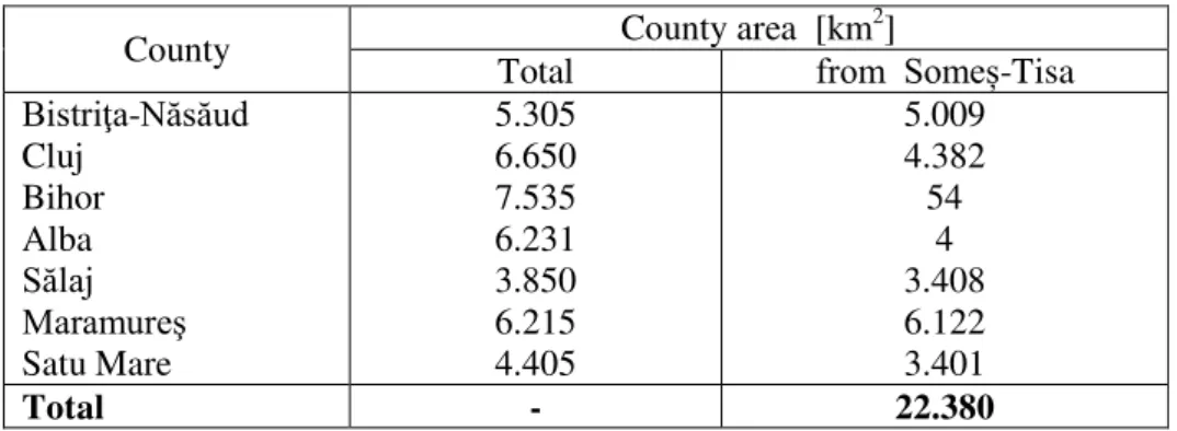
Table 2. The counties from Someș-Tisa river area
County County area [km
2
]
Total from Someș-Tisa
Bistriţa-Năsăud Cluj
Bihor Alba
Sălaj Maramureş
Satu Mare
5.305 6.650 7.535 6.231 3.850 6.215 4.405
5.009 4.382 54
4 3.408 6.122 3.401
Total - 22.380
3.2. The Hydrographic network
The hydrographic Someş-Tisa River Basin comprises of 580 streams encoded with a length of 7828 km river network [7].
The hydrographic sub-basin and major collectors are:
Tisa: Tisa River in Romania gathers 123 of water courses, with a total length of 1592 km (2% of total network length coded in the country), the main
rivers are the Vișeu, Iza and Tur. The 4,540 km2 of the basin represents 1.9% of the country and 20% of the Someş-Tisa basin. Coded network density is 0.35 km/km2 and forest area is 1,709 km2 and cover 37.6% of the basin.
Someș streams from Rodna Mountains and to the confluence with Someșul
Mic it is called Someșul Mare. The 403 coded streams totaling a length of 5528 km (7% of the total length of the country). Basin area is 15,140 km2 and represents
6.6% of the country and 71% of the Someș-Tisa catchment area. The average density of the network is 0.35% and the forest area is 4,688 km2, which represents 29.8% of the catchment area.
The main rivers are: Someș (including Someșul Mare) with a length of 376 km up to leave the country, Someșul Mare with a length of 130 km and an area of
5,033 km2. Its main tributaries are Şieu, Almaş and Lăpuş. The Someșul Mic, with a length of 178 km and an area of 3,773 km2reception, called the Someșul Cald up
to the confluence with Someșul Rece in Gilău lake and its main tributaries Someșul Rece, Nadăș and Fizeş.
4. THE STRUCTURE AND CONTENT OF THE SOMEŞ-TISA MPHCA
Management Plan Someș-Tisa catchment area was structured framework based on content provided in Annex VII of the Water Framework Directive, on the following chapters:
1. Introduction. Water legislation 2. Overview H.B.
3. Characterization of surface waters 4. Groundwater characterization
5. Identification and mapping of protected areas 6. Monitoring and characterization of water status 7. Environmental objectives
8. Programmes of measures
9. Exceptions to environmental objectives 10. Conclusions
5. PROGRAMS OF ESTABLISHED MEASURES IN SOMEȘ-TISA CATCHMENT AREA
5.1 Environmental objectives MPHCA
Specific environmental objectives established for the first planning cycle Management Plan are presented below:
Fig. 2. Specific environmental objectives established for the first Management Plan
If the environmental objectives cannot be achieved, it may require exceptions to attain them, under certain conditions, laid down in Article 4 (4) 4 (5), 4 (6) and 4 (7) of the WFD .
• Rehabilitation / construction of water supply infrastructure for 280 humane agglomerations;
• Rehabilitation/ construction of sewage-treatment infrastructure for 274 humane agglomerations;
• Reducing pressure point and diffuse caused by 66 sources of industrial pollution.
• Reducing diffuse pollution from agricultural by applying the specific action programs in 124 communes in areas vulnerable to nitrate pollution;
• Reduction of the sale, handling, storage, use and transport of plant protection products and reduction of pesticides in water bodies;
• Reducing point pollution caused by 59 fams and livestock.
5.3 Program of additional measures include 22 additional steps and 23 application tools / support them, which were established in industry, agriculture and hydro morphology in order to achieve the good status / good ecological potential:
• the hydro morphology domain: endowment of dams with H <15 m passage for migrating fish fauna; dams are located on heavily modified water bodies, rivers, with moderate ecological potential, where the presence of transverse sealing prevents fish migration; execution facilities for migrating fish fauna bottom threshold H> 0.8 m located on heavily modified water bodies in moderate ecological potential; transverse barring removal that have lost the function for which they were executed; clogging and works to stabilize the banks for fish accumulations on the Fizeş River, under moderate ecological potential.
• for agricultural activities application of the code of good agricultural practices in areas of non-vulnerable areas located in areas at risk of nutrients; desilting pits former poultry area to reduce pollution from industry: studies and applying the results obtained to implement optimal solutions to mine water treatment plants; study the possibility of temporary accumulation of old mining galleries pending measures based on the collection-mine-water treatment; study on the possibility of temporary taking over the wastewater from the SC Protan SA Dej in the treatment
plant SC Someş Dej SA.
• to groundwater: Studies to assess the nature and quantity of pollutants in soil and subsoil and quantification transfer mechanisms and degradation through the underground, in order to estimate the possibilities of reducing
the amount of nutrients in groundwater body of Someş Mare floodplain
6. CONCLUSIONS
The first Someș-Tisa River Area Management Plan [6]:
• is the planification instrument in water domain to the hydrographic basin;
• sets targets for a period of 6 years (2009 -2015) based on knowing the first state of body waters;
• propose measures to ensure water sources and to achieve "good status" of water in their sustainable use;
• is the component of qualitative management of water resources in the scheme of Arrangement and Management Directories hydrographic area. The new sort of evaluation of the ecological and chemical state for the water bodies according to WFD represents a major challenge, because of the first start of utilization and methods of analysis and evaluation based on common principles at European level. This process in accordance with the requirements of the WFD involves efforts to ensure the monitoring data for the introduction, implementation and testing of new methods of analysis and evaluation of water status [9].
The water bodies which were classified as heavily modified bodies will be reassessed in subsequent cycles and improving function, which can pass into the category of natural bodies. Number of water bodies to which it applies exceptions will decrease significantly in the next planning cycle, following the environmental objectives to be achieved for all water bodies by 2027, application exceptions can be adapted in the following plans management [9].
REFERENCES
1. Şerban P., Galie A., 2006; Water Management, Principles and European
regulations, 67-91, 121-124, 130-137
2. Sofronie, C. Hydro-technical structures in the Someș-Tisa, 266 +20 pp., Gloria Publishing House, Cluj-Napoca, 2000, ISBN-973-9203-72-8
3. Sofronie, C. Integrated management of water resources Someș-Tisa, in Hydro, vol.42 (1997), No. 5.
4. Sofronie, C. Plan for prevention and control of accidental pollution of water
resources in the Somes-Tisa. The Environment & Progress, no. 4/2005
5. Sofronie, C. Safe operation of landfills in the Someș-Tisa. In Disaster and Pollution Monitoring, Science, November 1-2, 2007
6. Sofronie, C., Bayer, Cristina. Plan management of water resources in the Someș -Tisa, 253 pages, Publisher UTPRESS, Cluj Napoca, 2012, ISBN 978-973-662-714-9.
7. Sofronie, C., Stoica, F., Selagea H. ș.a. Someș-Tisa, 300 pages, Publisher UT Press, Cluj Napoca, 2013, ISBN 978-973-662-901-3.
8. *** Area Management Plan Someș-Tisa River, Water Directorate Someş-Tisa Cluj
Napoca, 2009, approved by Government Decision no. 80/2011, published in the Official Gazette, Part I, no. 265 bis.
9. *** Directiva Cadru Apa 2000/60/C.E.