Lakes, reservoirs and ponds, vol. 4(2): 152-166, 2010
©Romanian Limnogeographical Association
VIDRARU RESERVOIR, ROMANIA.
ENVIRONMENTAL IMPACT OF THE HYDROTEHNICAL
CONSTRUCTIONS ON THE UPPER COURSE OF
ARGES RIVER
Laura Ana MITITELU
Argeş-Vedea Water Basin Administration, Piteşti, România mititelulaura2000@yahoo.com
Abstract
Having an important hydrographic system, with a significant discharge potential and being located in a place that has all the forms of relief, the basin Arges is, at present, one of the most complex hydroelectric facilities from all the rivers with reservoirs in the country. Vidraru reservoir is the biggest of its 11 reservoirs. The information (data) about the management of the water in Walachia dates from the year 1576, and the oldest writing about protection against floods is known as the “Ipsilantis canal”, which stated that the big waters of Dambovita river were deviated at Lunguletu in the riverbed of Ciorogarla rivulet and dates from 1774.The effects caused by the hydrotehnical constructions on the environment are numerous and profound, both positive and negative. In this essay, the analysis of the environmental impact of the hydrotehnical facilities on Arges River is made from two perspectives. The first method of analysis is the Water Directive 2000/60 and the second method is basd on a SWOT analysis, a method taken from the economy, but very efficient in establishing the current state, and also the perpective of this environemental impact.
Keywords: impact, hydrotechnical facilities, SWOT analysis.
1. Geographic features of the upper course of Argeş hydrographic basin
The upper hydrographic basin of Argeş is situated in the center-south of the country, being comprised in the north-south direction between the 45o36’ parallel in
the upper area and the 44o50’ parallel in the lower area, and respectively in the
west-east direction between the 24o30’ and the 25o28’ meridians. From an altitudinal
viewpoint, it presents very varied altimetric indicators, including the highest Carpathian Mountains (Făgăraş Mountains - 2543 m) and unfolds up to about 300 m (the High Plain of Piteşti).
In the north and north-west, it is situated near the hydrographic basin of Olt, from which it is separated by large interfluves, and in the north-east and east it is situated in the vicinity of Ialomiţa Basin.
Within these limits, Argeş has a total length of 122 km, and together with its tributaries it drains a territory whose surface covers 3,261 km2.
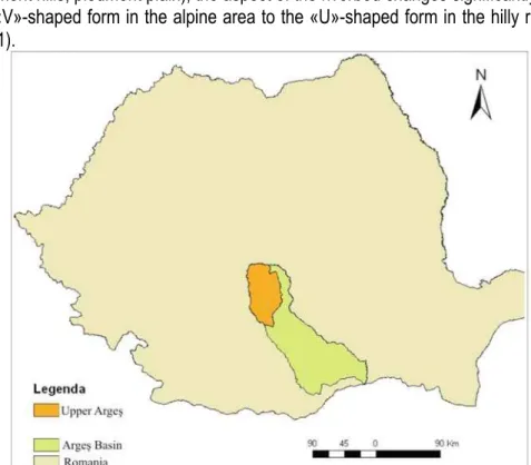
In its passage through several relief units (mountains, subcarpathian and piedmont hills, piedmont plain), the aspect of the riverbed changes significantly, from the «V»-shaped form in the alpine area to the «U»-shaped form in the hilly regions (fig. 1).
Fig. 1. Geographic setting of the hydrographic basin of Upper Arges
It presents a dendritic, asymmetrical basin, and an almost rectilinear course, with a marked deviation eastwards. The hydrographic network in the area under analysis is represented mainly by Argeş River and by a number of 19 of its first order tributaries, the rest of the courses comprised in the cadastre being of inferior orders (II, III, and IV). One of the features of Argeş River is the asymmetry with a leftside dominance from the viewpoint of the tributaries and the asymmetry with a rightside dominance from the viewpoint of terrace development (at Piteşti their number is of 5-7).
There are 9 tributaries on the right, with elongated basins. Among the most important, there are: Modrugaz, Cumpăna, Aref and Bascov. Their total length is 118 km and their area covers 308 km2 of the total upper and middle basin of Argeş.
The tributaries on the left (a total of 10) are much more developed. Among them, the most important are: Valea cu Peşti, Vâlsan, Râul Doamnei (the largest tributary in the area under analysis),Văleni.In agreement with the asymmetry of the basin and its more significant development on the left side, the length of the hydrographic network from here is of 266 km and it occupies an area of 2427 km2.
From an administrative viewpoint, the entire area is located on the territory of Argeş County. Within the area under analysis, the diversity of the geographic
landscapes reflects the complexity of the relief forms. So, from north to south, there is a series of relief steps: high mountains (over 2000 m), low and medium mountains (800 - 1000 m), Subcarpathian and piedmont hills (300-800 m), and piedmont plain. The difference of altitude between the source and the entrance of the river in the plain area is of about 2260 m. The relief is structured in parallel bands, oriented east-west. The main morphostructural units of the area under analysis are the result of a long evolution and have the following weight in the basin area: mountains - 29%, Subcarpathian hills - 44%, piedmont hills - 19% andpiedmontplain (fig. 2).
2 Short history of the hydrotechnical arrangements in the upper hydrographic basin of Argeş
The first attempts to realize general hydrotechnical works, hydroelectric power plants on the Romanian waters belong to several remarkable engineers from the beginning of the 20th century. In the year 1934, Prof. Dorin Pavel publishes the
work “Plan général d’aménagement des forces hydrauliques de Roumanie” (General arrangement plan for the hydraulic forces of Romania).
After the Second World War, the development of the country in the domain of hydroelectric power required a series of studies which analyzed the usefulness of reservoir construction and the evaluation of the hydroelectric power potential.
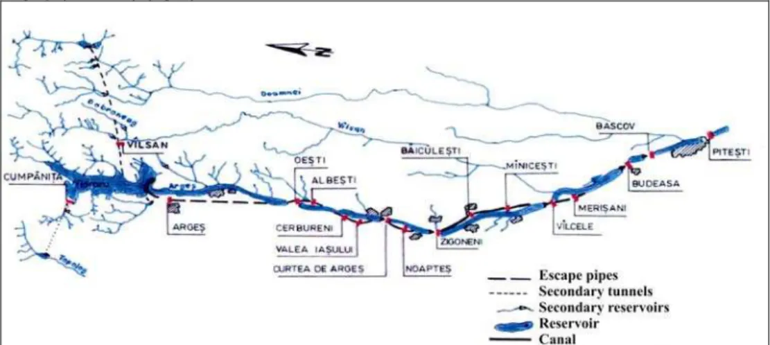
In the basin of Argeş, the first large hydroelectric power works began with the arrangement from Vidraru (1965-1971), which, with a height of 166.6 m is the highest dam in Romania (with a volume of 465 million m3). The complex
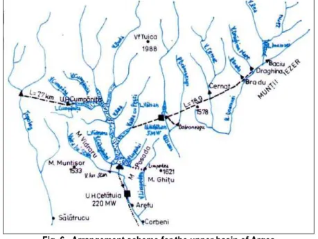
arrangement scheme of Argeş River in the upper course comprises a chain of 11 reservoirs (Vidraru, Oeşti, Cerbureni, Curtea de Argeş, Zigoneni, Vâlcele, Budeasa, Bascov, Piteşti, Prundu şi Goleşti), 16 electric power plants, to which should be added the secondary branches: Râul Doamnei-Vâlsan-Argeş (Vidraru), Topolog-Argeş (Vidraru) (fig.3).
Fig. 3. General scheme of Argeş River development
Hydrological and technical parameters of the Vidraru reservoir
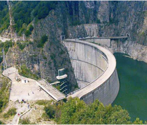
The Vidraru arrangement constitutes a first step in the arrangement of Argeş River, its realization being decided on November 1, 1960, its purpose being to produce electric energy, to supply with water the towns downstream (Curtea de Argeş, Piteşti and Bucharest), to provide water for irrigations, pisciculture and recreational activities.
The hydrotechnical arrangement is made up of: a dam holding the reservoir, a main water supply system, a balance tank, a forced intake pipe, an underground hydroelectric power plant – the first of its kind in Romania, from where the water is evacuated through an escape pipe, unique at the time of its construction (fig.4).
Fig. 4. Vidraru Lake dam
At present, the Vidraru hydroelectric power system is managed by S.C. “Hidrocentrale” S.A., the branch Hidrocentrale (Hydroelectric power plants) Curtea de Argeş. It began to operate in the year 1966 and presents complex functions: water supply, high flood attenuation, hydropower production, irrigations, and recreational activities. Its main characteristic data are: surface at normal retention level NNR 870.0 ha; dimension at normal retention level NNR 830 mdM; volume at normal retention level NNR 465 mil. m3; high flood reduction volume 22 mil.m3;
maximum dam height 166.6 m; type of dam – doubly curved arc.
The hydroelectric power plant was built between 1961 and 1966, a record period for such a work; it was the second hydroelectric power plant in Romania after that of Stejaru-Bicaz, on Bistrita River, compared to which it presents different features, however.
Following the approval of the arrangement scheme for Argeş River during
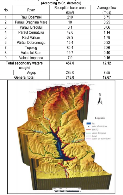
the period 1955-1960, on the proposal of the engineers M. Sipiceanu and S. Bogdan, relying on direct measurements that lasted for 18 years at the
hydrometric station Tunel - Argeş and for shorter periods on the tributaries upstream the dam, this work foresaw the catching of the waters of nine rivers, all with an area of 457 km2 (61.5% of the total), bringing into Vidraru lake a flow of 12.12 m3/s) (table
1, fig. 5.).
Table 1. Secondary waters caught and brought into Vidraru reservoir (According to Cr. Mateescu)
No. River Reception basin area (km2)
Average flow (m3/s)
1. Râul Doamnei 210 5.75
2. Pârâul Draghina Mare 10 0.25
3. Pârâul Bradului 3.1 0.06
4. Pârâul Cernatului 42.6 1.14
5. Râul Vâlsan 67.9 1.78
6. Pârâul Dobroneagu 15.4 0.32
7. Topolog 80.4 2.26
8. Valea lui Stan 19.7 0.40
9. Valea Limpedea 7.9 0.16
Total secondary waters caught
457.0 12.12
Argeş 286.0 7.55
General total 743.0 19.67
Fig.5.Vidrau reservoir and drainage basin (Al.Nedelea, 2006)
So, the average yearly flow was supplemented from the ordinary 7.55 m3/s
of upper Argeş to 19.7m3/s, by catching the hydrographic network afferent to
Topolog, Vâlsan, Doamna and their direct tributaries from the alpine area. The waterfall, a significant parameter in the hydropower exploitation, consequently increased from 178.2 m to 324 m. With the adoption of this scheme, the power installed in the power plant increased from only 30 MW to 220 MW (7.33 times) (fig.6.).
Fig. 6. Arrangement scheme for the upper basin of Argeş
The secondary courses deviated towards the reservoir pass through tunnels in which water circulates gravitationally, dimensioned in such a way as to transport much higher flows than the average value of the waters caught. The eastern tunnels (Râul Doamnei-Vidraru) are 2.5 times bigger, the western one (Topolog-Cumpăniţa) is 3.5 times bigger, and Valea lui Stan and Limpedea are 5 times bigger. This situation was given by the demand to use a quantity of water as big as possible out of the annual suuply coming from the respective rivers.
For the realization of these secondary inputs, three dams were built, in the shape of an arc, made of steel: one on Râul Doamnei (Baciu) between the years 1965-1967, 34 m high and with a lake volume for normal retention level of 585 000m3; another on Vâlsan River, 25 m high and with the lake volume of 174 000 m3;
a third is situated on Cumpaniţa Valley, is 33 m high and has a volume of 288 000 m3. The latter two were built during the period 1966-1968. The remaining 6 were
obtained by creating dams along the water, as overflow thresholds, with arins that function automatically.
3. The impact of the hydrotechnical arrangements on the environment
The analysis of the impact produced by a hydrotechnical arrangement on the environment is complex and can be approached in many ways. In the present paper, the impact on the environment shall be analyzed from two perspectives. The first is that our country has the obligation to meet the requirements of the European legislation in the domain of water, so through the prism of the Water Framework Directive 2000/60/EC, while the second is an approach from the perspective of a SWOT analysis.
3.1. The Water Framework Directive 2000/60
The Water Framework Directive adopted by the European Parliament on October 23, 2000 was applied beginning with December 22, 2000, when it was published in the Official Journal of the European Union. The goal of the Water Framework Directive is to reach a “good condition” for all the water bodies, both situated at the surface and in the underground, except for the strongly modified and artificial ones, for which the “good ecological potential” is defined.
The article 5 of the Water Framework Directive foresees the need to analyze the anthropic pressures and their impact, mentioning that “each Member State must assure a review of the impact of the human activity on the status of surface waters and on groundwater”.
For the area under analysis, the significant pressures are the hydromorphological ones, considering the realization of Vidraru reservoir and of the other reservoirs downstream, which required works consisting in: transversal dams; works along the river – lateral dams, river regulation and riverside consolidation works; works for gathering and evacuating used waters and works meant to deviate a part of the flow.
The hydromorphological pressures result in: modification of the habitats due to physical alterations through transversal dams, lateral dams, canals, etc that influence the aquatic fauna and flora; the modification of the waters’ hydrological regime and of the sediments’ regime due to the significant flow regulations, extractions or returns; modifications of the water chemistry with local impact.
An important regulation brought by the Water Framework Directive 2000/60 is the definition of a new water category, namely – “strongly modified water bodies”. They are those water bodies that never reach a good ecological condition because of the deep alterations generated by human activities. The relevant human pressures are in the case of the strongly modified water bodies, those that produce the “physical alteration” of these bodies’ features. The physical alteration includes changes in the morphology and hydrology of the water bodies. The dams are the
classic examples of physical modifications that lead to changes in the hydrological regime.
From the analysis of the impact of the arrangements along Argeş Valley according to the criteria of the Water Framework Directive 2000/60, the resulting conclusion is that the natural environment of Argeş Valley has been irreversibly changed, which makes it necessary to take some rehabilitation measures in the future (wetland restauration, riverbed restauration and return to its natural condition), rehabilitation / relief modification reduction in the floodable riverside, repopulation of the minor riverbed with fish etc.
3.2. SWOT analysis – Vidraru reservoir
The SWOT analysis was used in an attempt to make an inventory as complete as possible of the effects induced by the arrangement of the reservoirs along Argeş Valley on the environment.
In table 2 are presented the analysis points according to the four aspects.
Table . 2. SWOT analysis of the environmental impact of the reservoirs
Strengths - S Weaknesses -W
water supply modification of the natural flow
production of electric energy modification of the riverbeds’ morphology increase of the irrigable areas interruption of the river continuity defense against flooding modification of the water quality fish exploitations occupying farm lands
tourist development landscape modification
Opportunities -O Threats -T
cheaper and non-polluting electric energy
risk of breaking and damage
tourist development clogging and eutrophisation
amateur fishing modification of the riverbed morphology
jobs impact on the flora and fauna
administrative infrastructure works
Strenghts
The arrangement of Argeş River highlights as main functional effects the electric energy production, the assurance of the water supply, the regulation of the water flows in Argeş basin, by which we understand the decrease of the risk of flooding, as the water surplus can be kept in the reservoirs.
-The production of non-polluting electric energy. The realization of the 14 hydroelectric power plants along Argeş River up to Piteşti with an installed power of 407 MW, and an electric energy production of about 770 GW/year has beneficial immediate and permanent effects.
Modifications of the natural water course. Following the use for
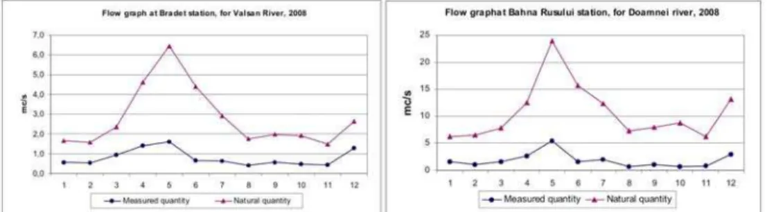
hydropower and given the existing deviations within the system, significant water transfers appear from one basin to the next. So, through the main secondary branch Vâlsan-Vidraru situated in the alpine area of the basin, providing a supplementary water volume in Vidraru Lake, Vălsan River loses a significant amount of water (fig. 7.). One can notice the significant difference between the reconstituted (natural) flow and the flow measured at Brădet hydrometric station (Ph) situated downstream from the deviation.
Fig. 7. The average annual flows, at Brădet Ph, for Vâlsan River, and at Bahna Rusului Ph, for Doamnei River
The influence can be noticed very well during the low and average waters. In 2007, a year affected by drought, the recorded flow (1.0 m3/s) represented only
30 % of the flow it should have been naturally (3.3 m3/s). The same situation is
encountered for Doamnei River, another river caught in the upper basin through Baciu reservoir and directed through a secondary branch towards Vidraru reservoir. The values of the difference vary between 18.1 % in 2007 and 98% in 2005. So, the impact of these arrangements is both positive and negative. For Argeş River, through the passage of the water from one basin into the next, an extremely important extra volume and flow is gained, from the viewpoint of the hydroelectric power, but at the same time Vâlsan River and Doamnei River lose a large part of their natural flow, which affects their ecosystem downstream.
- The water supply for different uses is assured by the water stored and through the regulation of the flows in the reservoirs and the secondary branches. The arrangements on Argeş River are meant to assure drinkable water for three big towns: Bucharest, Piteşti and Curtea de Argeş (about 3.2 mil. inhabitants), with a volume of 225,828 m3 and an extra volume of about 200,000 m3 water for industrial,
agricultural and piscicultural uses.
- The risk of high floods is significantly reduced through the attenuation of the high floods in the lake chain, following strictly respected exploitation regulations. During the high flood of 2005, Argeş River did not produce any damage, and Vidraru Lake reached its maximum retention level (832.85 mdM), the water being evacuated through the surface overflow.
Weaknesses
- The modification of the natural flow regime is one of the principal weak points. By deviating the flows to supply the reservoirs on Argeş River, the flow of Argeş River increased, while the flows of the deviated rivers from the upper basin (Vâlsan and Râul Doamnei) decreased. The most eloquent example is given by the project of the arrangement, as for an optimal functioning of Vidraru Lake, it was determined to supplement the average flow coming into the lake from 7.5 m3/s to
19.7 m3/s by catching the nine rivers from the upper basin of Argeş River. In the
graphs from fig. 8, one can notice the difference between the measured and the reconstituted flow regime.
Fig. 8.The flow in 2008 at Brădet Ph, for Vâlsan River, and Bahna Rusului Ph, for Doamnei River
At Bradet Ph, for Valsan River, and at Bahna Rusului Ph, for Doamnei River, where we are only dealing with water caught upstream, and not with water restituted downstream, the graph of the natural and of the measured flows presents the same tendency, with the remark that the natural values are higher. For the maximum flow, it can be noticed that the peaks are removed and the difference between the extremes is reduced. The real impact produced on the flow regime on
Argeş River is the lowering of the maximum flow by attenuating the high flood waves and increasing the minimum flows by regulating the water stocks.
- The modification of the riverbeds’ morphology refers to two aspects: the appearance of new course sectors (the secondary branches meant to supplement the flow and the canals meant to reuse the water for energy) and the modification of the natural riverbed. The water’s transversal profile, and also the river’s longitudinal profile, have gone through numerous transformations in time. The appearance of the reservoirs led to the change of the balance profile, as the erosion diminished in certain sectors from where the water was taken away or became accelerated downstream, where the accumulated waters flow through the natural riverbed. In order to highlight this aspect, we analyzed the evolution of the riverbed at the Ph from Căpăţâneni (created in 1943), situated on Argeş River, at the river’s exit from the alpine area, downstream from Vidraru Lake, draining a 316 km2 area (fig. 9).
Fig. 9.Transversal profiles of Argeş riverbed in the area of Capăţâneni Ph
From the example provided, one can notice the mobility of the riverbed as the talweg changed from the right riverside in the year 1998 to the left riverside in the year 2001.
- Modification of the landscape. The landscape changed due to the appearance of a new ecosystem, the artificial lake, and implicitly due to the transformations induced by it (dam, water volume, higher riverside, topoclimate). - Changesin the water quality due to the lacustrine ecosystems with specific biotopic features (relatively stagnant volume with vertical temperature distribution, oxygen concentration, trophicity degree), which determine eutrophisations, affecting the qualitative parameters needed for the development of the aquatic life.
Opportunities
- The theoretical hydroenergy potential. In the upper basin of Argeş there
are adequate conditions for the creation of new arrangements able to valorize the entire existing potential through the construction of micro hydroelectric power stations.
-Tourism and recreational activities. The development of tourism represents at the same time an increase of the number of jobs offered and also of the recreational spots.
-Amateur fishing and pisciculture constitute an interesting issue, as the tourist flow would be favored by an adequate infrastructure.
Threats
- Damage risk for the hydrotechnical constructions; yet the proability of such damages is very low. The scenatios foreseeing the breaking of Vidraru dam, the most important of the entire chain, highlight the fact that the created wave would affect all the dams situated downstream, flooding numerous areas (a 200 m long breach in the dam at a height of 159 m would trigger a damage flow of 451,125 m3/s
(500.37 mil.m3), and a flood wave corresponding to this flow of 159 m at the dam,
corresponding to a 9.28 m wave at Piteşti.
- The clogging of the reservoirs hinders the functioning of the arrangement at the projected parameters, making it dissicult to provide the water needed for different uses
- The modification of the morphology of the riverbeds downstream, due to the lack of the alluvial deposits, which end up in the reservoir. Concerning the clogging, we must remind the impact of the modification of the riverbed morphology both upstream and downstream, following the depositing at the end of the lake.
- The impact on the initial flora and fauna through the appearance of new types of ecosystems; the variation of the lake level can have determining effects in the reproduction of the fish fauna and the development of the flora. Negative effects concerning the fish fauna can appear if the fish passages are not maintained.
The SWOT analysis provides conclusions meant to help in the elaboration of strategies and of a management that can help reduce/avoid the negative impacts and rehabilitate the affected or modified ecosystems.
Conclusions
The hydrotechnical arrangements, as the arrangement on Argeş River, significantly modify the morphology, the longitudinal profile and the water’s drainage regime. By the construction of the dam, the water level is increased and the areas in the vicinity of the riverbed are flooded. Through the creation of the reservoir, the transport of the alluvial deposits - dragged or in suspension - stops, beginning from the end of the lake (the area in which the speed regime changes). This fact leads to
the clogging of the lake, and in the case of the low-depth lakes, even to the creation of lacustrine deltas (swamps). The clogging process is accelerated in the case of flooding, which bring in very significant flows (dragged and solid in suspension) plus the quantities of alluvial deposits stored in the confluential areas, which at a normal flow would not have been transportable.
The positive effects actually coincide with the goals of the realization of these arrangements: producing electric energy, assuring the necessary water supply for Curtea de Argeş, Piteşti and Bucharest and the neighboring localities, regulating the liquid flow along the arranged rivers, avoiding or diminishing the risk caused by flooding, assuring the water flows needed for socio-economic units, agriculture (irrigations), pisciculture. The complexity of the effects induced in all the environmental components by the hydrotechnical arrangements causes multiple interactions, with different degrees of importance. Having in view the need to valorize the water, given their complex functions, the effects of these arrangements are positive for the society. By means of the anthropic intervention, the balance of the natural environment undergoes significant modifications, especially negative. Through a rigorous analysis of the effects, regardless of the method of analysis (be it the Framework Directive or the SWOT analysis), the negative issues are determined and solutions are searched to improve them, or, in case the situation does not allow it, to maintain the present condition without allowing it to get worse.
Bibliography
Bocioacă, M. (1970), Lacul Vidraru. Studiu hidrologic preliminar, [Vidraru lake. Preliminary hydrological study], Lucrările Colocviului de Limnologie fizică,
Institutul de Geografie, Bucureşti
Constantinescu M. (1990), Construcţii hidrotehnice în România [Hydrotechnical Constructions in Romania], Edit. Hidroconstructia, Bucureşti
Diaconu C., Serban P. (1994), Sinteze şi Regionalizari Hidrologice [Hydrological Syntheses and Regionalizations], Edit. Tehnică
Diaconu C., Dumitrescu S., Lăzărescu D., Ujvari I. (1954), Scurgerea medie specifică a râurilor din R. P. Română[The Specific Average Flow of the Rivers in the Popular Republic of Romania],Lucr. DGH, Seria hidrol., 1
Gâştescu P. (1988), Resursele de apă ale râurilor României si repartiţia lor în teritoriu [Water Resources of the Romanian Rivers and Their Repartition in the Territory],Terra, nr. 3-4, Bucureşti
Gâştescu,P., Driga,B.(1996), Lacul de baraj antropic-un ecosistem lacustru aparte [Anthropic dam lake-a apart lacustru ecosystem], Revista Geografică, II-III, Institutul de Geografie Bucureşti
Gâştescu P. (2002), Resursele de apă ale bazinelor hidrografice din România [Water Resources of the Hydrographic Basins in Romania], Terra, vol.1-2
Gâştescu P. (1990), Water resources in Carpathians and their economic management, RRGeogr. 34
Gâştescu P., Driga B., Sandu Maria (2003), Lacurile de baraj antropic – între necesitate şi modificări ale mediului [Anthropic dam lakes – between necessity and environmental changes], in the tome “Riscuri şi Catastrofe” [Risks and Catastrophes], II, Editor Sorocovschi, V., Edit. Casa Cărţii de Ştiinţă,
Cluj-Napoca
Ionescu Şt. (2001), Impactul amenajărilor hidrotehnice asupra mediului [The Impact of the Hydrotechnical Arrangements on the Environment], Edit. H.G.A., Bucureşti.
Nedelea, Al. (2006), Valea Argeşului în sectorul montan. Studiu geomorphologic
[Argeş valleyinmountain section.Geomorphologycal study], Edit. Uninversitară, Bucureşti
Rădoane Maria, Rădoane N. (2003), Impactul construcţiilor hidrotehnice asupra dinamicii reliefului [The Impact of the Hydrotechnical Constructions on the Relief Dynamics], in the tome “Riscuri şi Catastrofe” (Risks and Catastrophes), II, Editor Sorocovschi, V., Edit. Casa Cărţii de Ştiinţă, Cluj-Napoca.
Teodor S. (1999), Lacul de baraj si noua morfodinamica. Studiu de caz pentru râul Arges [The Dam Lake and the New Morphodynamics. Case Study: Argeş River], Edit. Vergiliu
Zăvoianu, I., (1978), Morfometria bazinelor hidrografice [Hydrographic Basins Morphometry], Edit.Academiei Române
Zăvoianu, I., (1993), Romania’s water resources and their use, GeoJournal, 21, I *** (1972-1979), Atlas R.S.România, Inst.Geografie, Edit.Academiei Române *** (1983), Geografia României [Romania’s Geography], vol. I, Geografie Fizică
(Physical Geography), Edit.Academiei Române
*** (1971), Râurile României (monografie hidrologică) [The Rivers of Romania. Hydrological Monograph], IMH, Bucureşti
*** (1992), Atlasul Cadastrului Apelor din România [Atlas of the Water Cadastre in Romania], Bucureşti
*** (1996), Directiva Cadru 2000/60 a Consiliului Europen [Water Framework Directive 2000/60/EC]
*** (2004), Planul de Management al spatiului hidrografic Arges-Vedea
[Management Plan of the Argeş-Vedea Hydrographic Area]