Transformation of Fragile Environments Jörg Winistörfer, Emmanuel Reynard 267
Transformation
of
Fragile
Environments
in
the
Alps
and
in
the
Sahel
Jörg Winistörfer, Emmanuel Reynard, Lausanne
1
Introduction
In the previous publication «Geography in Switzerland»
in Geographica Helvetica 1980,Vol. 35, No 5, we
sum-marised the results of research on the
paleogeograph-ical reconstruction of late glacial stages in the Valais
Alps
(Winistörfer
1980). This field of research was themain thrust of physical geography at the University of
Lausanne at the end of the 1970s and supported by «Les
amis du quaternaire lemanique», a group of researchers
who informally worked during ten years under the
direc-tion of Prof. emeritus M. Burri. Research in this area dominated over two decades, resulting in two important
regional studies. Dorthe-Monachon (1993) and
Sch-oeneich (1998) reconstructed the stages of the glacier
retreat in the lateral Valleys on the right bank of the
Rhone river and in the Ormonts, Etivaz and Hongrin
Valleys, respectively. In addition, Aubert (1979) and
Arn
(1984) from the geology department of the Universityof
Lausanne completed the studies of the upper and lower
Rhone basin.
Currently, quaternary geomorphology and paleocli-mate reconstructions are no longer an important axe
of research and teaching in physical geography at the
University of Lausanne. This has been replaced by
four new orientations, which give more importance to the understanding of current geomorphological proc¬ esses and their dynamics, and also to the interaction
between the physical environment (the geomorpho¬
logical environment especially) and human societies:
The study of transformations in agricultural
prac-tices in the Sahel countries under the combined
effects of environmental and socio-demographical
changes;
The study of the pereeption of natural hazards in
alpine societies and the effects of this pereeption on
defence strategies;
The study of the dynamics of periglacial environ¬
ments and their evolution in relation to global cli¬
mate changes;
The study of institutional management of water
resources in alpine regions.
The common denominator of these four research directions is the concern for fragile environments.
In the Sahel fringe, for example, environmental
characteristics deteriorated drastically following the
1969-1973 and 1984-1985 droughts; in the Alps, the
strong reaction of thermal regimes and the dynamics
of processes involved due to recent climate change
may be seen in the negative reactions of the perma¬
frost belt. A further common concern is the
fragility
of the societies that live in these environments as
they depend greatly on the natural processes. TTiis
is as true for rural Sahel societies, who must adapt
their agricultural practices to the pluviometric Situ¬
ation, as it is for alpine communities, for whom the
landscape is an essential factor (natural risks,
natural
resource management). This focus on rural or nat¬ ural environments compliments the courses offered
in human geography on urban environments
(Da
Cunha & Racine, this volume).
2 Transformation of fragile environments and the consequences
2.1 Agricultural practices in Sahel environments
The Institute of Geography at the University
of
Lausanne
(IGUL)
began to develop teaching andresearch activities in Niger (Fig. 1) following the
1984-1985 droughts, within the framework of two
programs, UNIGEO, financed by the Swiss Agency
for Cooperation and Development
(DEZA)
and the Dean's Office of the University of Lausanne, andSPP-E (Environment and
Agricultural
Systems intheSahel: dynamics, interactions and internal
innovation
capacities), financed by the Swiss National Science Foundation (SNF). In Burkina Faso, a program was
set up to evaluate the eultivation technique of «zai» (financed by the Universite Lausanne-Ecole Poly-technique Federale de Lausanne). This
agricultural
technique consists of digging holes in a field, in which
the farmer puts the seeds and the manure. The tech¬
nique allows manure and water to be concentrated
at the base of the plant. These different projects
have led to a lasting two-way scientific Cooperation
between the universities of Lausanne and Niamey. Since 1985, over 40 diploma theses have been com¬
pleted by Swiss students in Niger.
The first publications concentrated on the
characteri-sation of physical environments and highlighted the
deterioration of natural resources (see for example,
various articles in the publication edited by
Bridel
etal. 1994 and Bergoeing &
Dorthe-Monachon
1997).Attention was then focused on the rural societies and their reactions to a changing environment. Indeed,
the current drop of rainfall averages, although it is not new, is the most extreme and the fastest deteriora¬
tion that has oecurred in the last ten thousand years
Legende
100 mm Isohyete(moyenne 1961-1
100mm Isohyete (moy
Zonepastorale
Zoneagricole
Niger
MALI TAHOU7
Anadez
DW¥A
TILLABER
Tanoua
Zn
IAC BURKINA
FASO
800 mr? ^"800mm BENIN DOSSO
Fig. 1: Map of Niger, pluviometrical isohyetes and Situation of the principal study zones. This map shows the
regions which have lost about 100mm of rain in the past 30 years. It is the most sensitive zone in the Sahelian
region due to the fact that both population groups, i.e. farmers and herders compete for land use in the zone.
Karte des Niger, pluviometrische Isohyeten und Lage der hauptsächlichen Untersuchungsgebiete. Diese Karte zeigt
die Regionen, welche in den vergangenen 30Jahren rund 100 mm Regen eingebüsst haben. Es ist dieempfindlichste
Zone der Sahel-Region aufgrund der Tatsache, dass sich Bauern und Viehzüchter in der Landnutzung in dieser
Zone konkurrenzieren.
Carte du Niger, des isohyetespluviometriques etde laSituation desprincipales zones soumises ä Tetude. Cette carte localiseles
regions qui ontperdu environ 100 mm de pluie durant les dernieres 30 annees ecoulees. La zone laplus sensible est laregion
sahelienne, dans la mesure oü les deuxpopulations, les cultivateurs et les eleveurs, s'affrontent en mattere d'usage dusol.
Source: Direction de la Meteorologie Nationale Niamey, Niger; Cartography: G. Clivaz, Institut de Geographie,
Universite de Lausanne
Based on a systematic and interdisciplinary approach,
our research aims to understand the different natu¬
ral, economic, social and cultural dimensions of agri¬
cultural production in the current context of yield
decreases, soil degradation, general drop in
fertility
and demographic growth, changes in the value Sys¬
tems, and division of production units which
charac-terises Sahel agriculture
(Baechler
1996).Inspired
by agricultural analysis methods developed in the 1980s, our work aims to «measure» the capacities of adaptation and the implementation of Substi¬
tution strategies by the village communities when
facing the transformation of their production envi¬
ronment.
Research carried out in the Dallol Bosso has brought
to light different survival strategies used by the popu¬
lation in difficult periods, such as informal activities,
rural exodus, commercial grazing, selling of fodder to
the cities and begging. The results are a disruption
of
the traditional social System and the trend to seil land and traditional rights.
Another research project in the Zinder region (in the
east of Niger) by Waziri Mato (2000) shows that, in
a context marked by continuous deterioration of pro¬
duction conditions and an extremely hierarchical social system leaning heavily on the natural resources, the
counter-season cropping around the ponds formed atthe
end of the rainy season diversifies the population's diet and makes up for the chronic deficit of the rainy season. This, therefore improves the population's State ofhealth.
Due to this, the ponds have an important development
Transformation of Fragile Environments Jörg Winistörfer, Emmanuel Reynard 269
important constraints is certainly the problem of land availability as the wet areas are currently attraction poles for all actors - farmers, herders and fishermen.
More recently, in 2002/2003, in collaboration with the
Geneva International Academic Network
(GIAN)/
Reseau universitaire international de Geneve
(RUIG),
the Institute engaged in a research project on water
problems in three semi-arid regions: Niger, Syria and
India. TTie Institute is primarily responsible for the
research in Niger. The program deals with water and
health-related questions and aims to investigate opti¬
mal water-usage under given conditions.
2.2 Representation of natural hazards
The National Research Program 31 (Climate Change
and Natural Hazards) offered the opportunity to set
up two research projects on the representation of nat¬
ural risks. TTie first studied the representation of
ava-lanche risk and the resulting social behaviour (popula¬
tion reaction, political management, and deployment of preventive measures)
(Herold-Revaz
et al. 1998).The second analysed the representation of various
natural risks (avalanches, landslide movements, floods,
foehn gales, etc.) and the resulting land occupation
strategies in the Vallee des Ormonts (Vaud Pre-Alps)
(Schoeneich & Busset-Henchoz 1998). The authors
showed that the populär knowledge of landslide proc¬
esses and torrential phenomena was insufficient.They also showed the validity of traditional strategies
(con-cerning land occupation or architectural adaptation),
as well as the role of collective memory, which pro¬
vided a sort of hazard zoning in the region studied, and
constitutes therefore a non-negligible element of risk
prevention. These results reflect results obtained in the Sahel concerning populär knowledge, the empirical and operational knowledge of farmers and the
appro-priateness of these in terms of adaptation to environ¬
mental changes
(Winistörfer
1996).2.3 Cartography and monitoring of alpine permafrost
Several researchers at the Institute have concentrated
on a third research domain over the last ten years
-the mapping and monitoring of alpine permafrost. This
field has gained on importance in the context of cur¬
rent global warming. Research in this field follows dif¬ ferent lines: mapping of the spatial distribution, char-acterisation of the ice content, understanding of the geomorphological processes and study of the reaction of permafrost to climate warming. Our recent research
has concentrated on five study sites: Mont Gele/Mont
Fort and the Aroila regions (Valais), the Diablerets
(Vaud), Creux du Van (Neuchätel) and the region
of
Posets (Central Pyrenees, Spain). These studies had the following aims: mapping of permafrost distribu¬
tion at a regional scale (Lambiel & Reynard 2001),
characterisation of the ice content in periglacial envi¬
ronments, more precisely the glacier forefields
degla-ciated since the end of the Little Ice Age
(Reynard
et al. 2003), study of the interaction between perma¬
frost and avalanche barriers
(Phillips
2000), as wellas study of the thermal behaviour of very low altitude
sites situated well below the lower limit of discontinu-ous permafrost
(Delaloye
et al. 2003).These different studies allow the processes taking place in permafrost zones to be better understood. We have
thus been able to highlight the important role ofthermal
circulation for the formation and preservation of frozen bodies in scree (Delaloye et al. 2003), as well as thecom¬ plex relationships existing between glacial and periglacial
dynamics (Reynard et al. 2003) and between permafrost
and avalanche barriers (Phillips 2000). These different
publications have also allowed us to document andbetter
characterise the distribution of permafrost at a regional
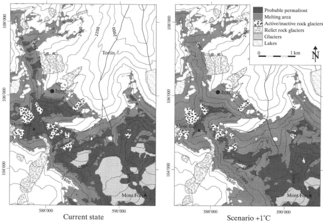
level (Fig. 2, Lambiel & Reynard2001).
The research in the Mont Gele region is currently inte¬
grated in the PERMOS project (Permafrost Monitor¬
ing in Switzerland) project, whose aim is to create
a permafrost Observation network in the Swiss
Alps
(Delaloye
& VonderMühll
2002). Two sites stud¬ied by the Institute of Geography of the University
of
Lausanne
(IGUL)
have been monitored in this con¬nection since 1999. Investigations of thermal behav¬ iour at ground level and drillings have been conducted
at both sites. However, our research in this area can
also be seen as the investigation of natural hazard pro¬
tection in connection with debris flows. Particularly
for
the regional authorities debris flow constitutes aseri-ous problem. Thus, the Natural Risk Section of the
Canton of Valais is partially funding a PhD thesis at
our Institute on this topic.
2.4 Institutional water resource management
The Alps and mountain regions in general, are an important resource for societies, in terms of wood,
landscape, water, etc. (Messerli & Ives 1997). The
most important of these resources is water. The Insti¬
tute has developed over the past ten years a series
of
research projects focusing on water resource manage¬
ment in the Alps.
These studies look at the institutional aspects of water management. They concentrate on the problem
of
local management of common-pool resources
(Hardin
1968, Ostrom 1990), using an analysis framework
specifically tailored for this purpose -
institutional
resource regimes (Varone et al. 2002). The analysis
of
natural resource management by institutional resource
regimes (IRR) entails the systematic analysis of the
influ-mhablcpermafrost WM Meltingarea
\nsfLf*Active/inactive rock glai
^£P Relict rock glaciers
iGlaciers
_JLakes
w^
;
"%*
km
¦
0*'f
-¦'-,ifiPo
588*000 590'00C
Current State
88'000 590'000
Scenario +1°C
Fig. 2: Current distribution of permafrost and glaciers in the Mont Gele
(Verbier) region and projection in a
context of a 1°C global warming.
Gegenwärtige Verteilung des Permafrosts und der Gletscher in der Region des Mont Gele (Verbier) und Projektion
in den Kontext einer Erwärmung um 1°C.
Reparation courante du permafrost et des glaciers dans la region du Mont Gele (Verbier); projection dans un
contexte d'l °C de rechauffement.
Source: Reprinted from «Regional modelling of present, past and future potential distribution of discontinuous
permafrost based on a rock glacier inventory in the Bagnes-Heremence area (Western Swiss Alps)» by C. Lam¬
biel and E. Reynard from Norwegian Journal of Geography, 2001,55/4, pp. 219-223, by permission of Taylor
&
Francis AS.enced by two institutional components: property rights,
already highlighted by Ostrom (1990), and public
policies for the protection and exploitation of these
resources. The analysis of the accompanying develop¬
ment of these two components of institutional regimes
allows the historical evolution of water management
in Switzerland to be described and qualified (Varone
et al. 2002).
Our research aims to understand the reasons of the
many conflicts in local water management in various
alpine Valleys more precisely and to show the role
played by Community management associations.Thus, the goals of this research field reflect those of the
Sahel research projects on agricultural environments.
The studies focus mainly on two management envi¬
ronments: mountain tourist resorts (Reynard 2000)
and the irrigation canals in Valais, locally known
as bisses. TTie latter is characterised by a predomi¬
nant Community management system of the resource (Reynard & Baud 2002). Our work has notably
shown the importance of historical and
institutional
factors (for instance, the administrative make-up)
in
the current water management system in Valais, a
system which is neither integrated nor sustainable
(Reynard 2000). We have also shown that the Com¬ munity irrigation associations in Valais, which are
often presented in literature as prime examples
of
healthy and stable institutions, are actually
under-going extreme changes due to a major agricultural
depression, the demographical erosion of their mem¬
bers and the structural modifications that Swiss agri¬ culture is currently being subjeeted to (Reynard
&
Transformation of Fragile Environments Jörg Winistörfer, Emmanuel Reynard 271
3 The scientific contributions 3.1 Interdisciplinary research
Most of the research currently being carried out by
physical geographers at the Institute of Geography
of
the University of Lausanne
(IGUL)
is not limited tothe domain of geomorphology. In all research areas, we collaborate and develop study projects with
col-leagues in the natural and human sciences. In per¬
iglacial environments, the technical and methodologi¬ cal contributions by geophysicists allowed substantial
advances to be made in the question of the
charac-terisation of ice contained in frozen ground and in the glacier forefields. In arid environments, it was only through the combination of geomorphological, earth sciences, botanical and agronomical approaches, that
the impacts of agricultural practices on the
evolution
of the natural environment could be suitably evalu-ated. At the Institute, geographers collaborated
with
sociologists and linguists to evaluate farmers'
per-ceptions of the environment, and in the Alps,
his-torians, geographers and political analysts worked
together to study natural risks or management ofnat¬ ural resources.
3.2 Research centred on the actors
Current research carried out by geomorphologists at the Institute constitute the traditional domains of physical geography (aridity, natural hazards, per¬ mafrost, and water resources). With the exception of the research on permafrost, all of our research projects centre on the actors involved, and less on
the objeets themselves. Thus, in the Sahel, the agri¬
cultural practices and their modulations under the effect of environmental transformations are stud¬ ied. On the question of water resources, we focus
our attention on the management institutions them¬ selves. In the domain of natural hazards, we centre
our study on the pereeption of risks and the result¬
ing social behaviour.
3.3 Research oriented toward practical application
It is in particular in the Sahel countries that the ori-entation of the Lausanne research toward practical application is the most evident. In line with the research-development Steps established in the 1980s, the Institute projects aim clearly at elevating the level and quality of life of the populations concerned with¬
out losing their academic nature (Waziri Mato 2000).
Any interference in social practices must be carried
out with precaution
(Winistörfer
1998). One of the tangible results of the relationship between the uni¬versities of Niamey and Lausanne is the establishment
and development of a Student counselling office
in
geography which, since then, has proved to be a relia¬
ble actor in a whole series of applied research in Sahel
environments.
3.4 Methodological contributions
This resolute orientation towards
interdisciplinary
research also implies the development of new meth¬ odological tools. The main methodological contri¬ butions of physical geography research at the Insti¬
tute concern the use of qualitative methods in the
study of Sahel soil management
(Dorte-Monachon
1998) or natural alpine risks (Schoeneich &
Bus-set-Henchoz
1998). A thesis project currently beingfinished has developed a method of evaluation
for
natural reserves in Switzerland
(Gentizon
2003). In the research on periglacial environments, the systematic combination of different types of geo-electrical prospections and measurements of ther¬mal regimes at and below the surface have allowed detailed descriptions of the study zones' character¬
istics to be made (e.g. Reynard et al. 2003;
Dela¬
loye et al. 2003).
4 Conclusions and perspectives
This brief presentation shows to what extent physical geography in Lausanne has renewed itself during the last twenty years. In particular, the orientation towards interdisciplinary research, and in the case of geo¬
morphology, the focus on quantitative and dynamic
research within permafrost studies, should be
empha-sised.
Over the next few years, the Institute aims to keep
up and expand on these two approaches. This can be
seen in the development of a new thrust of research,
which appears to be very promising, that is of the
study of geomorphological landscapes. Inserted in the
greater framework of the study of landscape and the
pressure human activities put on their development,
the research of geomorphological landscapes requires
a strong interdisciplinary approach. It requires an
approach which is at the interface between geomor¬
phology, the other natural sciences and the human sci¬
ences. From a methodological point of view, it will
ben-efit from the competence built up over these past years
by the Institute in a domain which we have not men-tioned in this article, that of geomorphological map¬ ping (Schoeneich & Reynard 1993). A first series
of
results were presented during a Conference on therela-tionships between geomorphology and tourism (Rey¬
nard et al. 2003) that the Institute organised for the
annual assembly of the Swiss Geomorphology Society.
The research on this subjeet (in the form of a Masters
thesis) is integrated into the activities of the research
group titled «Geomorphological Sites: research,assess¬ ment and improvement», established for thetime-span
2001-2005 by the International Association of Geo¬
morphologists. The coordination of the research group
References
Arn, R. (1984): Contribution ä Tetude stratigraphique
du Pleistocene de la region lemanique. - These de doctorat, Faculte des Sciences, Universite de
Lausanne.
Aubert, D. (1979): Les Stades de retrait des glaciers du Haut-Valais. - These de doctorat, Faculte desSciences,
Universite de Lausanne.
Baechler, A. (ed.) (1996): Agri-cultures en mutations.
- Niamey, Annales de l'Universite Abdou Moumouni.
Numero hors serie..
Bergoeing, J.-P. & C
Dorthe-Monachon
(1997):Etude preliminaire de la morphologie du site
Salt-Hapex-Sahel, Niger, 1995. - Z. Geomorph. NF, 41/4,
505-518.
Bridel
L.,Morel
A. & I. Ousseini (dir.) (1994): Aucontact Sahara-Sahel. Milieux et societes du Niger.
-N° hors-serie de la Revue de Geographie Alpine, Col¬
lection Ascendances.
Da Cunha, A. & J.-B. Racine (2003): Teaching and
Research in Urban Geography at the University
of
Lausanne: A model at the beginning of a new Century.
- Geographica Helvetica 58,3:214-220.
Delaloye,
R., Reynard, E., Lambiel, C,Marescot.
L. & R. Monnet (2003): Thermal anomaly in a cold
scree slope (Creux du Van, Switzerland). - In: Phillips, M., Springman, S. & L. Arenson (eds): Permafrost.
-Proceedings of the 8,h International Conference on
Permafrost, Zürich, 21-25 July 2003. - Lisse: Balkema:
175-180.
Delaloye,
R. & D. VonderMühll
(2002):Mit
PERMOS Permafrost erforschen. - In: Die
Alpen
10/2002:29-32.
Dorthe-Monachon,
C. (1993): Etude des Stadestar-diglaciaires des vallees de la rive droite du Rhone
entre Loeche et Martigny. - Lausanne: Institut de
Geographie, Travaux et recherches n° 10.
Dorthe-Monachon,
C. (ed.) (1998): Methodespour comprendre et mesurer les pratiques agraires enmilieu
tropical et leurs transformations. - Lausanne:
Institut
de Geographie, Travaux et recherches n° 16.
Gentizon, C. (2003): L'evaluation des reserves natu¬
relles en Suisse. - These de doctorat, Faculte des Let¬
tres, Universite de Lausanne (forthcoming).
Hardin, G. (1968): The tragedy of the commons. - In: Science 162:1243-1248.
Herold-Revaz, A.,
Dulex Putallaz,
S. & L.Bridel
(1998): Representation du risque d'avalanches et
com-portements sociaux dans deux communes valaisannes.
- Zürich: vdf Hochschulverlag.
Lambiel, C. & E. Reynard (2001): Regional modelling
of present, past and future potential distribution of dis-continuous permafrost based on a rock glacier
inven-tory in the Bagnes-Heremence area (Western Swiss Alps). - In: Norwegian Journal of Geography 55, 4:
219-223
Messerli, B. & J.D Ives (eds) (1997): Mountains ofthe
World. A Global Priority. - London, New York: Par¬
thenon Publishing.
Ostrom,E. (1990): Governing the Commons:The Evo¬
lution of Institutions for Collective Action. - Cam¬
bridge: Cambridge University Press.
Phillips, M. (2000): Influences of snow supporting structures on the thermal regime of the ground in
alpine permafrost terrain. - Davos: Eidgenössisches
Institut für Schnee- und Lawinenforschung.
Reynard, E. (2000): Cadre institutionnel et gestion des
ressources en eau dans les Alpes: deux etudes de cas
dans des stations touristiques valaisannes. - In: Swiss
Political Sciences Review 6,1: 53-85.
Reynard, E. & M. Baud (2002): Les consortages d'irrigation par les bisses en Valais (Suisse). Un Sys¬
teme de gestion en mutation entre agriculture,
tour-isme et transformation du paysage. - In: Aubriot, O.
& G.
Jolly
(dir.): Histoires d'une eau partagee. Pro¬vence, Alpes, Pyrenees. - Aix-en-Provence: Presses de
l'Universite de Provence: 187-212.
Reynard, E., Holzmann, C, Guex D. & N. Summer¬
matter (eds) (2002): Geomorphologie et tourisme.
-Lausanne: Institut de Geographie, Travaux et Recher¬
ches n° 24.
Reynard, E., Lambiel, C,
Delaloye,
R., Devaud, G, Baron, L.,Chapellier,
D., Marescot, L. & R. Monnet (2003): Glacier/permafrost relationshipsin
forefields of small glaciers (Swiss Alps). - In: Phil¬
lips, M., Springman, S. & L. Arenson (eds): Perma¬
frost. - Proceedings of the 8th International Confer¬
ence on Permafrost, Zürich, 21-25 July 2003. - Lisse: Balkema: 947-952.
Schoeneich, P. (1998): Le retrait glaciaire dans les
vallees des Ormonts, de l'Hongrin et de
l'Etivaz
(Prealpes vaudoises). - Lausanne: Institut de Geogra¬
phie, Travaux et recherches n° 14.
Schoeneich, P. & E. Reynard (eds) (1993): Cartog¬
raphie geomorphologique, cartographie des risques.
-Lausanne: Institut de Geographie, Travaux et Recher¬
ches n° 9.
Schoeneich, R & M.-C. Busset-Henchoz (1998): Les Ormonans et les Leysenouds face aux risques naturels. - Zürich: vdf Hochschulverlag.
Varone, F., Reynard, E.,
Kissling-Näf
I. & C.Mauch
(2002): Institutional Resource Regimes. The Case of
Water in Switzerland. - Integrated Assessment 3:
78-94.
Waziri Mato, M. (2000): Les eultures de
contre-sai-son dans le Sud de la region de Zinder (Niger).
-Lausanne: Institut de Geographie, Travaux et Recher¬
ches n° 15.
Winistörfer,
J. (1980): Late pleistocene and holoceneglacier extents in the Alps of Central Valais. - In: Geo¬
graphica Helvetica 35,5:53-56.
Winistörfer,
J. (1996): Recherche universitaire etTransformation of Fragile Environments Jörg Winistörfer, Emmanuel Reynard 273
en mutations, Niamey: Annales de l'Universite
Abdou
Moumouni: 17-24.
Winistörfer,
J. (1998): Une geographie pour le Sahel,point de vue du geographe du Nord. - In: Methodes
pour comprendre et mesurer les pratiques agraires en
milieu tropical et leurs transformations. - Lausanne: Institut de Geographie, Travaux et recherches n° 16:
3-7.
Prof. Dr. Jörg Winistörfer, Dr. Emmanuel Reynard, Institut de Geographie, Uni versite de Lausanne, BFSH
2, CH-1015 Lausanne.
Internet address