GUILHERME C. LESSA, ABÍLIO C.S.P. BITTENCOURT, ARNO BRICHTA and JOSÉ M. L. DOMINGUEZ
Laboratório de Estudos Costeiros, Centro de Pesquisa em Geofísica e Geologia,
Instituto de Geociências, Universidade Federal da Bahia, Campus Ondina, 40210-340 Salvador, BA, Brazil
Manuscript received on April 28, 1999; accepted for publication on May 30, 2000; presented byKenitiro Suguio
ABSTRACT
Todos os Santos Bay is a large (≅1000 km2), structurally controlled tidal bay in northeast Brazil. Three main drainage basins debouch into the bay, providing a mean freshwater discharge of 200 m3/s (prior to
1985), or less than 1% of the spring tidal discharge through the bay mouth. Based on the result of several sedimentological studies performed in the 1970’s, five surface sedimentary facies were identified inside the bay, namely i) transgressive siliciclastic marine sand facies; ii) transgressive bay sand-mud facies; iii) a transgressive carbonate marine sand facies; iv) regressive bay-mud facies, and v) regressive fluvial sand facies. The spatial distribution of these facies would follow, somewhat closely, the hydrodynamic-energy distribution inside the bay. Seismic profiles along the bay bottom indicate the existence of several paleochannels, 5-10 m deep, blanketed at least by three different sedimentary units. The topmost sedimentary unit, 5-20 m thick, appears to be associated with the regressive bay-mud facies, and assuming that it was laid down within the last 5000 years, sedimentation rates for the central and northeastern part of the bay would average at 2,4 mm/y.
Key words:estuary, sediment, stratigraphy, Holocene.
1. INTRODUCTION
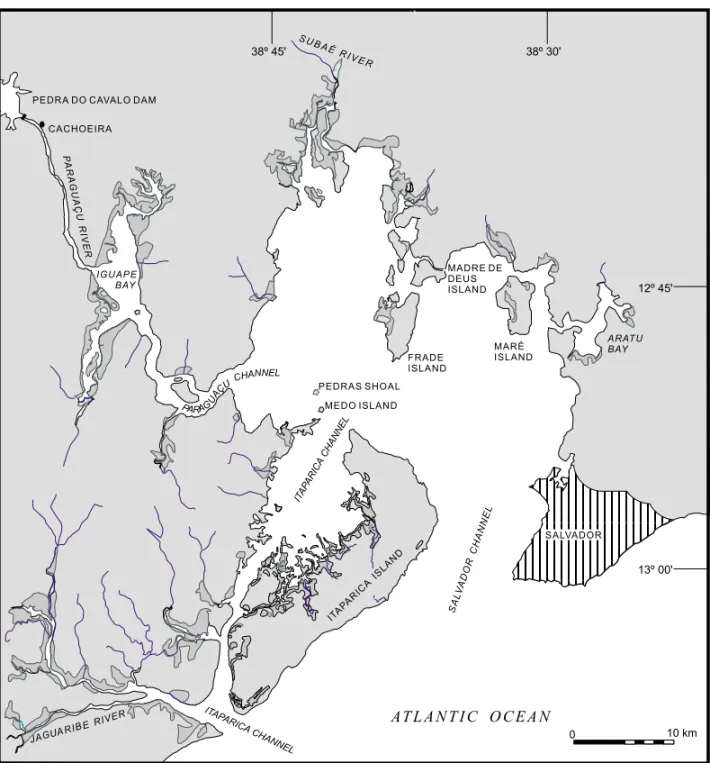
The Todos os Santos Bay (TSB) (Figure 1) is the second largest coastal indentation of the Brazilian coast, with an area of approximately 1000 km2. Ge-ological studies in the TSB date back more than 20 years, with an initial characterization of a calcareous shelly bank (Leão 1971). It was followed by sev-eral other studies, until the early 80’s, aimed to de-termine the general sedimentological aspects of the bay and the distribution of the surface sedimentary facies (Bittencourt et al. 1974, Bittencourt & Vilas Boas 1977, Nascimento 1977, Barros 1977, Leão & Correspondence to: Guilherme C. Lessa
E-mail: glessa@pppg.ufba.br
Bittencourt 1977, Avanzo 1977, Brichta 1977, Vi-las Boas & Nascimento 1979, Macedo 1977, ViVi-las Boas & Bittencourt 1979, Machado 1977, Leão et al. 1982, Araújo et al. 1984). Investigations on the stratigraphy of the bay are, however, very limited, being restricted to a seismic study by Pasenau and Brichta (1987) on recent tectonic structures.
evo-574 GUILHERME C. LESSA et allii
Fig. 1 – Location map of Todos os Santos Bay.
lutionary processes in estuaries in more recent years, propose a new distribution of the sedimentary facies inside the bay.
2. STUDY AREA
2.1 Geology and Geomorphology
The TSB has its origin related to Lower Cretaceous fault lines that formed the Recôncavo Basin (Medei-ros & Ponte 1981) (Figure 2). The basin is delimited
south-western margin and along the Paraguaçu channel, Upper Jurassic red sandstone intercalated with shale (Sergi Formation) predominate until Iguape Bay, where Cretaceous shale and siltstone (Santo Amaro Group) appears in sharp contact with the Pre-Cambrian basement along the Maragojipe fault. Quaternary deposits, including alluvial fan, marine terraces and mangrove occur along the margins, es-pecially at the western half of the bay (Figures 1 and 2). Quaternary alluvial fan deposits are restricted to the vicinity of the hills dominated by the Jurassic sandstone (Figure 2).
Sea level studies in the region indicate a Holocene post-glacial marine transgression max-imum of about 5 m at 5.600 cal. years B.P. (Martin et al. 1999), being followed since then by a general, albeit controversial, relative sea-level fall (Angulo & Lessa 1997, Lessa & Angulo 1998, Martin et al. 1998).
The TSB has two entrances separated by Ita-parica Island (Figure 1). The most important is the Salvador Channel, which seems to provide for most of the water exchange between the bay and the ocean (see Lessa et al. in press). Average and maximum channel depths are 25 m and 102 m, respectively, in relation to the Brazilian Hydrographic Authority’s (DHN) datum, henceforth adopted as a reference level (0 m DHN≅1.30 m below MSL). The Itaparica channel, to the southwest, presents a smoother to-pography with an average depth of 10 m. Maximum depths inside the TSB are associated with the strait north of Frades Island (over 60 m) and the passages to Aratu Bay (30 m) and Iguape Bay (50 m). Iguape Bay receives the discharge from Paraguaçu River (Figure 1), and a major fluvial delta shoals all its central part (Figure 3). Very shallow depths (< 5 m) characterizes the northern extremity of the TSB. Well developed ebb tidal deltas in front of both entrances suggest ebb-dominant conditions for most of the bay (see also Lessa et al. in press). Both deltas appear to be associated with the hydraulic barrier im-posed on the longshore-sediment drift by the tidal currents exiting the bay, given that sediment expor-tation appears to be minimum (Lessa et al. in press,
Bittencourt et al. submitted).
Coral reefs border the southeastern side of Ita-parica and Frade islands, as well as the southern side of Maré Island (Leão & Brichta 1996), all exposed to the E-SE swell. This suggests that marine, and not estuarine, conditions exist at least in the eastern half of the TSB (see also Wolgemuth et al. 1981). The non-existence of living coral reefs in the west side of the bay seems to be more related to higher water turbidity than to variations in water tempera-ture or salinity (Z. Leão, Geology Dept. - UFBA, per. comm. 1997).
2.2 Hydrology / Oceanography
sed-576 GUILHERME C. LESSA et allii
Fig. 2 – Geology map of the surroundings of Todos os Santos Bay (after Medeiros & Ponte 1981) and the general bathymetric contour of Todos os Santos Bay (source: DHN’s nautical chart 1:66:000).
iment concentration showed increasing values with depth, a phenomenon ascribed by Wolgemuth et al. (1981) to sediment resuspension.
3. DATA SOURCES
The characteristics of the surface sediments within the TSB derive from the work of Bittencourt et al. (1974) in Aratu Bay, Avanzo (1977) in Iguape Bay,
Fig. 3 – General bathymetry of Iguape Bay. The isobath of 0 m refers to low water level (after Avanzo 1977).
Seismic profiles (Figure 4) were executed in several sections of the bay utilizing an electric-acoustic profiler (ELAC) with a frequency of 18 kHz that allows 40 m of maximum penetration. Depth ranges were 0-48 and 0-96 m.
4. SURFACE SEDIMENT DISTRIBUTION AND FACIES
578 GUILHERME C. LESSA et allii
Fig. 4 – Location of the seismic profiling inside the TSB and profiles analyzed in this study.
shows the general distribution of 3 sediment-class sizes based on the Md (Iguape Bay, Avanzo 1977) and D50 (Brichta 1977, Bittencourt et al. 1976). Medium to very coarse sand is observed at the two entrances of the bay, at the exit of Paraguaçu River, along the western margin of Itaparica Channel and around Maré Island, as well as scattered zones within the central part of the bay. Fine to very fine
frictionally-dominated delta (Wright 1985), which is now pro-grading over a deeper, muddy zone at the upstream reaches of Paraguaçu Channel (Figure 3) (the impact of the Pedra do Cavalo dam on the fluvial sediment yield has not yet been assessed).
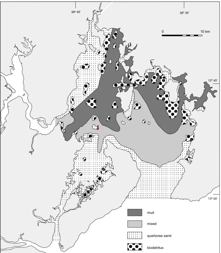
Based on the sediment texture and composi-tion, Bittencourt et al. (1976) proposed the exis-tence of four surface sedimentary facies inside the central part of the TSB, namely: quartzose sandy facies, muddy facies, carbonate facies and mixed facies (Figure 6). The quartzose-sand facies occur at the northern and southern entrances of the TSB and behind Itaparica Island. They possess, how-ever, different characteristics. Behind Itaparica Is-land sediment color varies between olive and gray, shows small percentages of carbonate fragments, the grains are sub-angular to sub-rounded and coated with clay, suggesting a non-marine origin. On the other hand, sand deposits from both entrances of TSB display yellow-grayish quartz grains, which are bright, clean and rounded to well rounded, suggest-ing marine origin. The carbonate facies is gray in color and is largely composed by carbonate ments (more than 50% of the weight). These frag-ments derived mainly from mollusks, equinoderms andHalimeda, and to a smaller degree from coral-linaceous algae and foraminifer. Subordinate clay makes always less than 30% of the total sample weight. The mud facies is composed by more than 50% of clay and silt, olive-gray in color, with subor-dinate quartz grains and carbonate fragments. The mixed facies is olive-gray in color, and characterized by a mixture (in different proportions) of quartzose sand, mud and carbonate fragments, with none ex-ceeding more than 50% of the total sample weight. Overall, all facies’ sediments are poorly to badly sorted, with the exception of those within Salvador and Itaparica Channels (Macedo 1977).
The classification of the sedimentary fa-cies above does not account for different sediment origins nor a chronological sequence. As acknowl-edged by Bittencourt et al. (1976), different mor-phometric and compositional characteristics of the sediments that constitute the sandy facies suggest
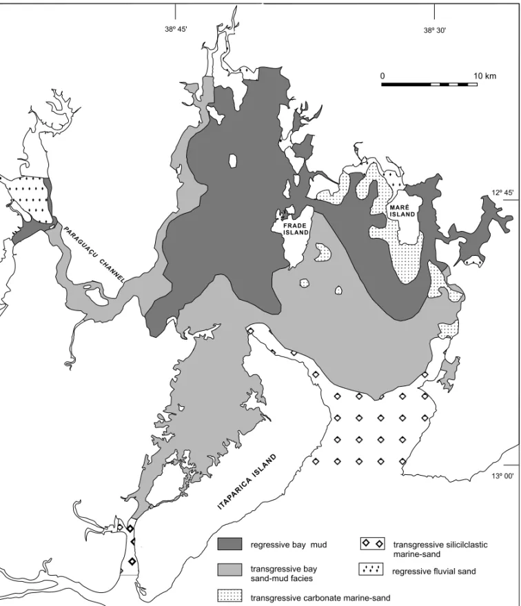
different sources. From an evolutionary standpoint, where bays and estuaries are transgressed by marine sediments during a sea level rise and subsequently infilled with continental deposits during a stillstand or sea-level fall (Roy 1984, 1994, Nichols et al. 1991, Dalrymple et al. 1992, Boyd & Honig 1992, Allen & Posamentier 1993, Lessa et al. 1998), high-stand, transgressive, and regressive sedimentary de-posits might be present in the bay bottom. A review of the standing facies classification is therefore pro-posed, with the differentiation of five surface sedi-mentary facies as follows: transgressive siliciclastic marine sand facies, transgressive carbonate marine sand facies, transgressive bay sand-mud facies, re-gressive bay-mud facies and rere-gressive fluvial sand facies (Figure 7).
Thetransgressive siliciclastic marine sand fa-ciesoccurs at the entrance of both Itaparica and Sal-vador channels. It must be associated with landward transport of marine sand into the bay during the last marine transgression. As indicated by Bittencourt et al. (1976), sediments are yellowish-gray in color, composed mainly by clean quartz grains and car-bonate detritus (derived mostly from mollusks, Hal-imedaand briozoas), the latter contributing between 10% and 50% to the total sample weight (Macedo 1977). Both quartz grains and the carbonate detritus are sub-rounded to rounded, and the coarsest grain size is above 1 mm in diameter.
580 GUILHERME C. LESSA et allii
Fig. 5 – Surface sediment size distribution inside the TSB. Data compiled from Bittencourt et al. (1976) (D50) for the main part of TSB, Brichta (1977) (D50) for Paraguaçu Channel and from Avanzo (1977)
(Md) for Iguape Bay.
the drowning of a shallow substrate (see below) dur-ing the Holocene sea-level rise. Reported sedimen-tation rates associated withHalimedain coral-reef areas are up to 6 cm per year (Freile et al. 1995), but much lower rates would be expected inside TSB due to larger water turbidity.
The transgressive bay sand-mud facies is
Fig. 6 – Surface sedimentary facies inside the TSB (after Bittencourt et al. 1976).
Macedo 1977). Higher carbonate content, above 75% per sample weight, is observed in the central part of bay (Bittencourt et al. 1976, Corrêa & Ponzi 1980), where and is characterized by fragments of Halimeda, mollusks and equinoderms, showing
ob-582 GUILHERME C. LESSA et allii
Fig. 7 – Reviewed surface sedimentary facies inside the TSB.
served in samples from Paraguaçu Channel and cen-tral part of the bay (Brichta 1977, Avanzo 1977, Macedo 1977), suggesting fluvial provenance of the sediments (Corrêa & Ponzi 1980). Inside the Ita-parica Channel, clay content is less than 10% and
pro-posed to be associated with the reworking of existing riverine and (upper?) estuarine deposits during the post-glacial marine transgression, and should be re-garded as palimpsest. Inside Itaparica Channel, and along the northwestern bay shore, the sediments are more likely to be associated to the reworking of al-luvial fan deposits born of Cretaceous sandstones (Sergi Formation, Figure 2).
Theregressive bay-mud faciesis silty clay, with less than 10% of sand (Bittencourt et al. 1976). The carbonate content is generally less than 20%, but may reach more than 50% locally, in areas pre-viously classified as a biodetritus facies (Figure 6, Bittencourt et al. 1976). Mollusk fragments make the bulk of the carbonate content within the regres-sive bay-mud facies. Corrêa and Ponzi (1980) sug-gest that the locally high carbonate content found within the regressive bay-mud facies is related to the outcropping of the transgressive sand-mud fa-cies presently undergoing downlapping. The fafa-cies is interpreted as upper bay sediments, delivered by the land drainage within the last 5000 years and with a possible, relatively high contribution of au-thoctonous carbonate sediments (see discussion be-low). This facies should be actively prograding over the transgressive sand-mud facies.
Theregressive fluvial sand faciesis observed inside Iguape Bay, at the outlet of Subaé River and possibly at the small river outlets to the north of Maré Island. Its sediment is poorly to moderately sorted (after Folk & Ward 1957), with angular to sub-angular grains and less than 5% of carbonate content (Avanzo 1977). This facies forms a pro-grading delta in front of Paraguaçu and Subaé rivers, and must be downlaping the regressive bay-mud and the transgressive bay sand-mud facies. A shallower bathymetry at the exit of Subaé River might be pre-venting the formation of a well defined river delta, as observed inside Iguape Bay (Figure 3).
5. BAY STRATIGRAPHY
Out of the several seismic transects inside the bay, six profiles (Figure 4) that best represent the nature
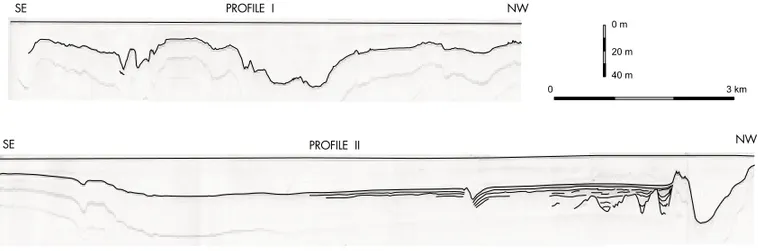
of the subsurface sedimentation were chosen to be analyzed in more detail. Profiles 1 and 2 (Figure 8) are characteristic of the bay entrance, where a gradation from sandy to sandy-mud sediments take place (Figure 5). The entrance of the bay shows an irregular topography characterized by a strong acoustic reflector at the surface, suggesting the out-cropping of the Cretaceous basement likely covered by sand in the smoother areas. The multiple re-flectors in Profile 2 are strong in the southeastern end but fade away into the more horizontal surface inside the bay, where they are replaced by internal reflectors indicating sediment infilling (in the region dominated by the regressive mud bay-mud – see Fig-ure 7). Closer to the northwestern end of Profile 2 (after fine tuning the gain level) some 20 m of sedi-ment can be observed covering an irregular reflector possibly associated with the Cretaceous basement. The navigation channel that leads to Madre de Deus Island (see Figure 2) is observed at the end of the profile, displaying again a strong reflector suggest-ing hard bottom. At least two sedimentary units are perceived on top of the deepest reflector at the north-western extremity of Profile 2 (Figure 10). The up-per unit is characterized by internal sub-horizontal reflectors, sub-parallel to the surface, with a maxi-mum thickness of 10 m. The lower unit fills in the paleovalleys, “with” an average thickness of 10 m. The prominent “dent” in the surface topography in the third-quarter of Profile 2 appears to fold down the internal reflectors. This feature has been inter-preted by Pasenau and Brichta (1987) as neotectonic in nature.
584 GUILHERME C. LESSA et allii
Fig. 8 – Seismic profiles 1 and 2, with internal reflectors and sea bed highlighted for clarity.
Fig. 9 – Seismic profiles 3, 4, 5, and 6, with internal reflectors and sea bed highlighted for clarity.
reflectors are all internal to a sedimentary unit, and show two generations of channel-fill deposits over 10 m in thickness each (Figure 10). A reflector asso-ciated to a pre-Holocene surface was not detected in this section, which suggests a deeper paleo-valley. As the topography descends towards the north, a strong reflector (see the multiples beneath) parallel to the surface appears at about 1 m below the bay bed. A similar reflector, which occasionally reaches the surface, prevails in the profile that run towards Paraguaçu channel and in the profiles between Ita-parica and Frade islands (Figure 4). Although no coring evidence exists, it is possible that this reflec-tor is associated with a shell layer. At the end of Profile 3, a topographical rise appears to be
associ-ated with almost 20 m of sediment accumulation at the exit of Aratu Bay channel (Figure 4). Sedimen-tation at this site might be ascribed to the confluence of the water flows that ebb from Aratu Bay and the area east of Maré Island.
Fig. 10 – Interpretation of the seismic profiles with possible sedimentary units.
lower unit, with uneven internal reflectors, fills in the paleovalleys and attain a maximum thickness of about 10 m.
Profile 5 (Figure 9) is a transect between the channels that lead to Madre de Deus Island andAratu Bay, crossing a plateau that extends to the south of Mare Island. A flat, shallow, hard (see multiples beneath), and very irregular surface prevails in the profile. Prior to the mid 1970’s this surface was cov-ered with shelly sediments (transgressive carbonate sand – Figure 7) that were dredged as row material for cement production. Removal of the sediment ex-posed the topographical unevenness that is possibly associated with a karst surface developed on a Pleis-tocene coral-reef structure. Shallower paleovalleys, cut into what appears to be the Cretaceous basement, are observed in the center of the profile. Whereas only one, 18 m thick sedimentary unit appears to fill in the eastern most paleovalley, the reflection patterns suggest the existence of three sedimentary units at the western ones (Figure 10). Given the reflection characteristics, the upper and lower sed-imentary units are equivalent to those identified in
Profiles 1 and 3 (Figure 10).
The channel leading to Aratu Harbor, at the eastern end of Profile 4, is underlain by a 20 m thick sediment package, which sits on top of an irregular basement reflector as deep as the present channel at the opposite (western) side of the profile. Internal to the sedimentary unit, the reflectors suggest the gradual accretion of a paleochannel which is likely related to the Aratu Bay paleodrainage. The west-ern channel, leading to Madre de Deus Island, shows only 5 m of sediment accumulation (Figure 10), sug-gesting either that the strength of the tidal flow has diminished little since the bay was flooded or that a tidal diastem (Lessa et al. 1998) is presently active along the channel.
586 GUILHERME C. LESSA et allii
River, here attaining a depth 60 m below mean sea level. Worth noting is a possible change in water density that appears to exist in the lower half of the channel, which would suggest a saltier layer and little mixing of the water column.
6. DISCUSSION AND CONCLUSION
The geologic framework of the TSB has been de-termined, to a high extend, by tectonism. Although the major fault systems were established in the Cre-taceous, reactivations occurred in the Tertiary and Quaternary, as indicated by several studies (King 1956, Tricart & da Silva 1968, Martin et al. 1986, Bittencourt et al. 1999). Vertical displacements in the order of meters during the Holocene (Martin et al. 1986) and historical records of earthquakes (Branner 1920), attest for the continuing adjustment of the basement beneath the bay. Such tectonic bear-ing appears to obscure the evidence of fluvial erosion that has likely occurred throughout the bay during successive lowstand episodes. For instance, the pa-leodrainage of the Paraguaçu River is not easily fol-lowed inside the bay and the closest canyon on the shelf (Salvador Canyon) is located some 50 km to the south of Salvador. Paleochannels, apparently with a E-W orientation and relief in the order of 20 m, are observed in profiles 2, 3 and 4 (Figure 9), suggest-ing a drainage orientation normal to the expected one (given the N-S direction of the present-day valleys in the area). Also, no major fluvial stream, that could give rise to these buried valleys, is observed today in the nearby area. As indicated by Tricart and da Silva (1968), the drainage basin that presently converge to the bay is still in embryo.
Despite this apparently significant tectonic control on the sedimentation of the TSB, and the paucity of subsurface geological data, it is still possi-ble to fit the observed sedimentary facies distribution into generalized models for sedimentation in incised valley systems in wave-dominated coasts (Dalrym-ple et al. 1992, Allen & Posamentier 1993, Roy 1994, Zaitlin et al 1994). In these models, a succes-sion of a marine, estuarine and fluvial facies exists,
with the extent of each individual facies (and their role in the infilling process of the estuary) being dic-tated by the distribution of energy (wave, tide and river) along the estuary, the estuary’s entrance con-dition (whether or not there is restriction imposed by a sandy barrier), and the fluvial sediment yield. A departure of the facies distribution of the TSB in re-lation to the models above is the existence of an ap-parently extensive palimpsest facies (transgressive bay sand-mud facies, Figure 7).
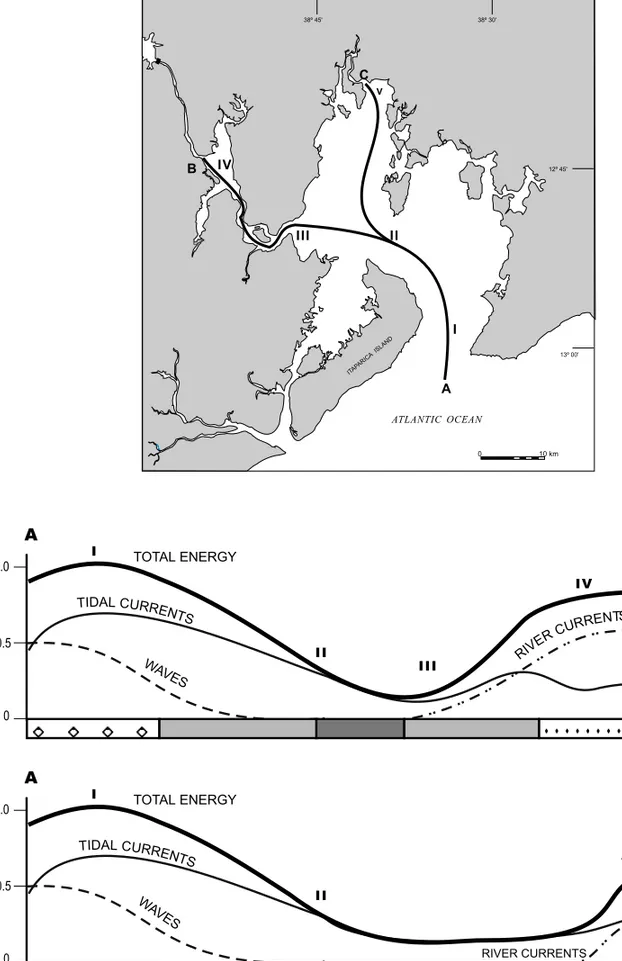
Figure 11 shows a schematic representation of this distribution of the relative energy along the bay, up to Paraguaçu and Subaé rivers, along with the distribution of the surface sedimentary facies (see also Lessa et al. in press). Tidal current velocities up to 1.20 m/s have been measured at the bay en-trance, waning towards the center of the bay (east of Frade Island, Figure 1) where maximum velocities are about 0.5 m/s during spring tides (Lessa et al. in press). Wave action appears to be significant only in the eastern half of the bay, as indicated by the distribution of beach deposits. The main rivers de-bouching into the bay possess small discharges and their influence would then be restricted to few kilo-meters downstream (in the case o Paraguaçu River, floods prior to damming might have been felt as far as the seaward end of Paraguaçu channel – Figure 1). The sedimentary facies distribution would fol-low, somewhat closely, the changes in the relative energy suggested for the bay. The large and un-obstructed entrance of the TSB allows for full tidal ranges and a more energetic environment inside, as compared to bays and estuaries with a depositional barrier in front that allows for the existence of a quiet, central basin (Dalrymple et al. 1992).
588 GUILHERME C. LESSA et allii
tation, we suggest that the lower unit in profiles 2, 4 and 5 (Figure 10) is pre-Holocene and possibly related to fluvial deposits laid down during the last lowstand(s). The intermediate sedimentary unit in Profile 4 could be associated with a transgressive system tract (Van Wagoner et al. 1988), and could still be of Holocene age. The lower unit in Profile 3 (Figure 10), is apparently associated with a recent process of channel fill, as suggested by its outcrop-ping, and could be related to the sedimentation of the regressive bay-mud facies.
Assuming that the regressive bay-mud facies accounts for all of the topmost seismic unit, it would have been deposited after the last post-glacial sea level maximum, or within the last 5,000 years. Knowing that the thickness of the upper sedimen-tary unit in the analyzed profiles varies between 5 m and 20 m, sedimentation rates associated with the regressive bay-mud zone would have varied from 0.8 mm/y to 4 mm/y, averaging 2.4 mm/y. This number similar to present-day rates of sediment ac-cretion assessed with210Pb for the same area of the bay, which are in the order of 1.5 mm/y (Roberto Argolo, Instituto de Física UFBA, pers. commun.). The sedimentation rate likely undergone by the TSB during the Holocene is also comparable to those ob-served in Guanabara and Paranaguá bays during the Holocene, which are likewise associated with the deposition of a regressive bay-mud facies. In Gua-nabara Bay, Amador (1980) found sedimentation rates around 1.5 mm/y for the last 5,000 years (it is worth mentioning is that recent sedimentation rates is in the order of 103mm/y due to deforestation and land use within the catchment area – Amador 1980). Implicit in the data of Lessa et al. (1998), the upper half of Paranaguá Bay might have experienced silta-tion of about 1,0 mm/y in the mid- to late-Holocene. As suggested by Corrêa and Ponzi (1980), lo-cally high carbonate content within the regressive bay-mud facies, between Frade Island and Para-guaçu Channel, would be related to “windows” ex-posing the underlying, carbonate rich transgressive sand-mud facies. The physical characteristics of the carbonate fraction, showing evident signs of
trans-port, supports such conjecture. However, the seis-mic profiles show a strong reflector, possibly asso-ciated with shell layers, extending continuously at about 1 m below the surface of the regressive mud fa-cies and cropping out locally. If the reflector marks the boundary between the transgressive and regres-sive facies, then only 1 m of the regresregres-sive bay-mud facies would have accumulated in most of the area between Frade Island and Paraguaçu Channel (Fig-ure 1). This is contrasting to the apparently much larger sediment accumulation associated with the re-gressive bay-mud facies observed in the northeast-ern part of the bay. We therefore suggest that at least part of the carbonate sediments apparently un-derlying the regressive bay-mud facies could be au-tochthonous.
ACKNOWLEDGMENTS
We are thankful to Ben Clennell for his help with the interpretation of the seismic profiles. G. Lessa, A. Bittencourt and J. Dominguez are under a research scholarship from the Brazilian Research Council (CNPq).
REFERENCES
Allen GP & Posamentier HW.1993. Sequence stratig-raphy and facies model of an incised valley fill: the Gironde estuary, France.J Sed Pet63:378-392.
Amador ES.1980. Assoreamento da Baía de Guanabara – taxas de sedimentação. An Acad Bras Ci52(4):
723-742.
Angulo RJ & Lessa GC.1997. The Brazilian sea level curves: a critical review with emphasis on the curves from Paranaguá and Cananéia regions. Mar Geol
140:141-166.
Araújo TMF, Leão ZMAN & Lima OAL.1984. Evo-lução do recife de coral da Ilha de Itaparica determi-nada a partir de dados geológicos e geofísicos. In: XXXIIICongresso Brasileiro de Geologia, 1., Rio de Janeiro.Proceedings..., Rio de Janeiro: SBG,
1984. p. 159-169.
(Dissertação de Mestrado, Universidade Federal da Bahia).
Barreto MAS & Paredes JF. 1995. Estudos hidro-dinâmicos no estuário do Rio Paraguaçu. Ciência e Tecnologia5:46-51.
Barros FC.1977.Estudo dos sedimentos biogênicos das enseadas dos Tainheiros e do Cabrito.Salvador, 76p.
(Dissertação de Mestrado, Universidade Federal da Bahia).
Bittencourt ACSP & Vilas Boas GS.1977. Ocorrên-cia de chamosita nos sedimentos recentes da Baía de Aratu.Rev Bras Geoci7(4): 230-238.
Bittencourt ACSP, Brichta A & Di Napoli E.1974. A sedimentação na Baía de Aratu. Rev Bras Geoci
4(1): 51-63.
Bittencourt ACSP, Dominguez JML & Ussami N. 1999. Flexure as a tectonic control on the large scale geomorphic characteristics of the eastern Brazil coastal zone.J Coast Res15(2): 505-519.
Bittencourt ACSP, Ferreira YA & Di Napoli E.1976. Alguns aspectos da sedimentação na Baía de Todos os Santos.Rev Bras Geoci6(4): 246-263.
Boyd R& Honig C.1992. Estuarine sedimentation on the eastern shore of Nova Scotia. J Sed Pet62(4):
569-583.
Branner JC.1920. Recent earthquakes in Brazil. Bull Seism Soc Am10(2): 90-104.
Brichta A.1977. A sedimentação na foz do Rio Para-guaçu. Salvador,113p (Dissertação de Mestrado,
Universidade Federal da Bahia).
CEPLAB (Centro de Planejamento da Bahia).1979.
Bacias Hidrográficas do Estado da Bahia. Séries
Recursos Naturais. Salvador: Governo do Estado da Bahia. 190 p.
Corrêa ICS & Ponzi VRA.1980. Estudo dos carbonatos associados aos sedimentos de fundo da parte oeste da Baía de Todos os Santos.An Acad Bras Ci52(2):
347-352.
Dalrymple RW, Zaitlin BA & Boyd R.1992. Estuar-ine facies models: conceptual basis and stratigraphic implications.J Sed Pet62(6): 1130-1146.
Folk RL & Ward WC.1957. Brazos River bar: a study in the significance of grain size parameters.J Sed Pet
27(1): 3-26.
Freile D, Milliman JD & Hills L.1995. Leeward bank marginHalimedameadows and draperies and
their sedimentary importance on the western Great Bahama Bank slope.Coral Reefs14:27-33.
King LC.1956. Geomorfologia da Região Oriental do Brasil. Rev Bras Geogr2:37-72.
Leão ZMAN.1971. Um depósito conchífero do fundo da Baía de Todos os Santos próximo à Laje do Ipeba.
Salvador, 56p. (Dissertação de Mestrado, Universi-dade Federal da Bahia).
Leão ZMAN & Bittencourt ACSP.1977. A fração biodetrítica dos sedimentos de fundo da Baía deAratu (BA).Rev Bras Geoc7(2): 115-130.
Leão ZMAN & Brichta A.1996. A plataforma conti-nental. In:Barbosa JSF & Dominguez JML(Ed.);
Texto explicativo para o Mapa Geológico do Estado da Bahia – Escala 1:1.000.000, SME, Salvador. p.
185-198.
Leão ZMAN, Muniz Ferreira MTG & Araujo TMF. 1982. Sedimentologia e estruturas biogênicas do re-cife de franja da Ilha de Itaparica, Bahia. In: XXXII Congresso Brasilerio de Geologia, Roteiro de Excursão, Salvador.Proceedings..., Salvador: SBG,
1982. p. 201-299.
Lessa GC & Angulo RJ.1998. Oscillation or not os-cillation: that’s the question – Reply.Mar Geol150:
189-196.
Lessa GC, Dominguez JML, Bitencourt ACSP & Brichta A.The Tides and Tidal Circulation of Todos os Santos Bay, Northeast Brazil: a general character-ization. Anais da Academia Brasileira de Ciências
(in press).
Lessa GC, Meyers S & Marone E.1998. Holocene stratigraphy in the Paranaguá Bay estuary, south Brazil.J Sed Res68(6): 1060-1076.
Macedo MHF.1977. Estudo sedimentológico da Baía de Todos os Santos. Salvador,75p. (Dissertação de
Mestrado, Universidade Federal da Bahia).
590 GUILHERME C. LESSA et allii
dos foraminíferos da Praia de Inema. Salvador, 76
p. (Dissertação de Mestrado, Universidade Federal da Bahia).
Martin L, Bittencourt ACSP, Flexor JM, Suguio K & Dominguez JML.1986. Neotectonic movements on a passive continental margin: Salvador region, Brazil.Neotectonics1(1): 87-103.
Martin L, Bittencourt ACSP, Dominguez JML, Flexor JM & Suguio K.1998. Oscillations or not oscillations: that is the question. Mar Geol150:
179-187.
Martin L, Dominguez JML & Bittencourt ACSP. 1999. Reavaliação das variações do nível relativo do mar ao longo do litoral leste e sudeste brasileiro: idades calendárias e informações adicionais. In: VII Congresso Associação Brasileira de Estudos do Quaternário, Proceedings..., Porto Seguro:
ABEQUA, 1999. viiabequa_zco001.pdf.
Medeiros RA & Ponte FC.1981. Roteiro geológico da Bacia do Recôncavo, Bahia. Salvador. PETRO-BRÁS/SEPES/DIVEN/Setor de Ensino na Bahia. 63p.
Mestrinho SSP.1998. Estudo do comportamento geo-químico dos metais pesados nos sedimentos da região estuarina do Rio Paraguaçu – BA.São Paulo, 158p.
(Tese de Doutorado, Universidade de São Paulo).
Nascimento AP.1977.Estudo sedimentológico das en-seadas dos Tainheiros e do Cabrito. Salvador.58 p.
(Dissertação de Mestrado, Universidade Federal da Bahia).
Nichols MM, Johnson GH, & Peebles PC.1991. Mod-ern sediments and facies model for a microtidal coastal plain estuary, the James River Estuary, Vir-ginia. J Sed Pet61(6): 883-899.
Pasenau HG & Brichta A.1987. Possibilidades inter-pretativas de estruturas tectono-sedimentares a partir de perfilagem eletro-acústica. ISimpósio Nacional de Estudos Tectônicos,Proceedings..., Salvador:
UFBA, 1987. p. 27-29.
Roy PS.1984. New South Wales estuaries: their origin and evolution. In: Thom BG(Ed.);Coastal Geo-morpholgy in Australia. Sydney: Academic Press,
p. 99-121.
Roy PS.1994. Holocene estuary evolution – stratigraphic studies from southeastern Australia. Incised-valley Systems: Origin and Sedimentary Sequences.SEPM Special Pub51:241-263.
Tricart J & da Silva TC.1968. Estudos de Geomor-fologia da Bahia e Sergipe. Fund. Desenv. Ci na
Bahia, Salvador, 167 p.
Van Wagoner JC, Posamentier HW, Mitchum RM, Vail PR, Sarg JF, Loutit TS & Hardenbol J.1988. An overview of the fundamentals of sequence stratig-raphy and key definitions. In: Wilgus CKet al. (Ed.);Sea-Level Changes: An Integrated Approach.
SEPM Special Publication 42, p. 39-45.
Vilas Boas GS & Bittencourt ACSP.1979. Química e Mineralogia da fração argilosa dos sedimentos do fundo da Baía de Todos os Santos, Bahia. Rev Bras Geoci9(3): 179-197.
Vilas Boas GS & Nascimento MAM.1979. Evolução paleogeográfica e paleoclimática da região das en-seadas dos Taineiros e do Cabrito, Bahia, nos últimos 5000 anos.Rev Bras Geoci9:159-168.
Wolgemuth KM, Burnett WC & Moura PL.1981. Oceanography and suspended material in Todos os Santos Bay.Rev Bras Geoci11(3): 172-178.
Wright D.1985. River Deltas. In: Davis R(Ed.); Coastal Sedimentary Environments. New York: Springer Verlag, p. 3-76.
Zaitlin BA, Dalrymple RW & Boyd R. 1994. The stratigraphic organization of incised valley systems associated with relative sea-level change. In: Dal-rymple R& Boyd R(Ed.);Incised-valley Systems: Origin and Sedimentary Sequences. SEPM Special