SRef-ID: 1684-9981/nhess/2004-4-655
© European Geosciences Union 2004
and Earth
System Sciences
Hazards caused by natural and anthropogenic changes of catchment
area in karst
O. Bonacci
Faculty of Civil Engineering and Architecture, Univ. of Split, 21000 Split, Matice hrvatske str. 15, HR-21000 Split, Croatia Received: 12 July 2004 – Revised: 6 October 2004 – Accepted: 13 October 2004 – Published: 1 November 2004
Part of Special Issue “Natural and anthropogenic hazards in karst areas”
Abstract.Determination of the catchment area is the starting point in most hydrological analyses. It serves as a basis for many hydrological and water resources management calcu-lations. The catchment boundaries and areas in karst regions are often fragmented and not accurately known. They can change over time due to natural and anthropogenic causes. Natural and man-made processes cause changes of catch-ment area on different time and space scales. Human in-tervention, especially construction of dams and reservoirs, as well as interbasin water transfer through long tunnels and pipelines can introduce instantaneous, definite and hazardous change. This paper presents seven examples of natural and anthropogenic factors which influenced changes of catch-ment area in the Dinaric karst: 1) Closing of the Obod Es-tavelle in the Fatniˇceko polje; 2) Operation of the Zakuˇcac hydroelectric power plant on the Cetina River; 3) Problems caused by Salakovac Reservoir; 4) Catastrophic flooding in the Cetinje Polje; 5) Regulation and canalization of the Trebiˇsnjica River; 6) Building of the underground hydroelec-tric power plant Ombla; 7) An earthquake in Southern Croa-tia and Western Herzegovina.
1 Introduction
Karst is typified by a wide range of closed and few open surface depressions, a well-developed underground drainage system, and strong interaction between circulation of surface water and groundwater. Karstification is primarily a geologi-cal characteristic important for water circulation and storage. Generally it is greatest at the surface and decrease with the depth of a karst massif. Karstification is a continuous pro-cess, caused by natural and/or anthropogenic interactions, so that even the most precise models and/or approaches are only temporally valid (White, 1988; Ford and Williams, 1989; Bonacci, 2001).
Correspondence to:O. Bonacci ([email protected])
Water circulation over and throughout karst terrain sig-nificantly differs from that in other types of terrain, pri-marily due to rapid rates of infiltration and the influence of the solutionaly enlarged underground aquifer, clearly distin-guishing it from porous aquifers and other types of fracture aquifers. Karst aquifers are generally continuous (Bonacci and Roje-Bonacci, 2000). However, numerous subsurface morphologic karst features strongly influence the continuity of aquifer, and commonly it does not function as a simple continuum within a catchment. Karst aquifers tend to be highly heterogeneous and anisotropic, although karst char-acteristics and structures are not totally random.
Conditions for water circulation and storage in karstified medium are strongly dependent on space and time scales be-ing considered, especially in the deep and morphologically complex vadose zone. This zone and the underlying phreatic karst aquifer are two-component system in which the major part of storage is in the form of true groundwater in narrow fissures and the matrix, where diffuse or laminar flow pre-vails. On the other hand, the majority of the water is transmit-ted through the karst underground by quick or turbulent flow in solutionaly enlarged conduits. The interaction between these two types of flow is significant and permanent. Natural karstification is a very rapid process with respect to geolog-ical time spans. Bakalowicz (1975) and Dreybrodt (1988) show that only a few thousand years are required to develop an integrated karst network. Human-induced changes can ac-celerate this strongly and dangerously.
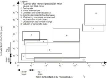
0 100
101
102
103
104
105
0 100
101
102
103 104
105 106
107
DURATION OF PROCESS [year]
linear
scale logscale linear scale
log scale
AREA INFLUENCED BY PROCESS [km 2] Legend:
1. Overflow after intensive precipitation which causes fast GWL rising
2. Earthquake 3. Man’s interventions 4. Landslide and land subsidence 5. Sinkhole development and collapse 6. Weathering processes, erosion and sedimentation in catchment 7. Deglaciation and climate change 8. Solution of carbonate rocks
5
4
3
1
2 6
7 8
Fig. 1. Time and space scale effects of different factors causing changes of the catchment in karst.
2 The catchment area in karst and its changes in time and space
A catchment area (drainage basin or watershed) is a topo-graphically defined area drained by a spring or open channel flow or system of connecting springs and channels such that all outflow is discharged through a single outlet. The deter-mination of the catchment boundaries and the catchment area is a starting point in many hydrological analyses. These are among the essential data which serve as a basis for many cal-culations for hydrological and water resource management purposes. In karst landscapes this is a difficult and complex task, which very often remains unsolved. Without this infor-mation it is not possible, efficiently and precisely, to make a water balance, to protect water from pollution, to manage the water resources, to use hydrological models etc. Generally speaking, the catchment area defined from surface morphol-ogy, (i.e. the topographic catchment), will rarely correspond exactly to the karst hydrological drainage basin. The differ-ences between the topographic and hydrological catchments in karst terrain are, as a rule, so large that data about the to-pographic catchment are useless in practice.
The root causes of problems of karst catchments determi-nation are: 1) Heterogeneous and anisotropic surface and un-derground morphologic karst forms; 2) Existence of well de-veloped, complex, deep and unknown underground networks of karst conduits, fissures, joints and cracks; 3) Strong inter-action between circulation of surface water and groundwater in karst; 4) High and fast oscillations of groundwater lev-els in karst (often a few hundreds of meters); 5) Strong con-nection between inflow (swallow-holes) and outflow (karst springs); 6) Small storage capacity of the karst medium and fast groundwater transport through karst conduits; 7) Differ-ent aspects of duality of water circulation in karst; 8) Nat-ural endogenous and exogenous processes; 9) Influence of Man’s induced structures and activities (dams, reservoirs, water pumping etc.).
When considering determination of catchment area in karst one should bear in mind that the karstification, i.e. the solution and redistribution of surface and subsurface karst features is a continual process, which cannot be stopped and controlled. At any given time, erosion processes can trans-port sediments underground, sinkholes develop and collapse, landslide and land subsidence occur, there is naturally plug-ging and unplugplug-ging of karst conduits due to tectonic move-ments, and Man’s induced influences can have strong effects on changes of karst catchment areas.
The catchment areas in karst may vary with variation in groundwater levels, i.e. change with time (Bonacci, 1987). There is a specific zone within which the watershed limit is moved towards one or the other spring or towards the stream-flow. The position of the watershed line depends upon the groundwater levels which change in time. In some situations, at very high groundwater levels (after heavy rainfall), fossil and inactive channels and springs are activated, causing the interbasin overflow and/or redistribution of the catchment ar-eas (Bonacci, 1995).
Determining of the catchment area of the poljes in karst is an extremely complex task due to fact that a given polje is only part of a wider system. It represents a subsystem in the process of surface, subsurface and underground water flow through the karst massif.
Lowering of the base level, related to tectonic uplift, re-gression of the sea level massive regional groundwater over-pumping or interbasin water transfer cause the development of a new water connections, which result in new karst catch-ments areas.
Before approximately 19 000 years ago the global sea level was about 100 m lower than now. It represented the erosion basis for many karst areas, so that the coastal spring out-lets were at that level. As the sea level rose, new conduits simultaneously formed in the karst together with the new, higher positions of the coastal spring exits. This process is still going on. The direct consequence is gradual change of the catchment areas of coastal karst springs. Change in the position of the coastal karst springs depends upon the local geologic structure. Each actual coastal karst spring has a few conduits. Some of them are active and some are inac-tive. The main reason for inactivity is existence of clay or some other obstruction (plug) in conduit. Natural (e.g. earth-quake) or Man’s interventions, which can lead to instanta-neous changes of spring catchment area, can remove such plugs.
Tectonic processes, which caused formation of faults and folds, influenced the subdivision of aquifers and establish-ment of catchestablish-ment areas in karst terrains. Choppy (1997) states that faults and folds can play various roles for water circulation in karst: a preferential drain, a barrier or no ef-fect.
2
7 3
1
6
4 5
BOSNIA HERZEGOVINA
ADRIATIC
SEA SERBIA
MONTENEGRO
ALBANIA
Legend:
state boundary river
Adriatic Sea coast study area
N 0
10
20 km
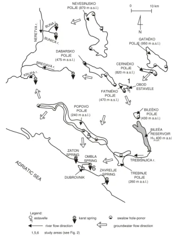
Fig. 2.The map with indicated positions of the seven study areas.
terrains those processes very often are uncontrolled, and re-sult in hazardous consequences.
Under the increased water pressure due to filling a reser-voir it is possible to wash out the clay or sand from clogged karst conduits (Breznik, 1998). Dreybrodt and Siemers (1997) warn that dams and reservoirs in karst accelerate evo-lution of new karst channels below the dam, which can cause serious water losses within its lifetime.
Drastic changes in groundwater level caused by karst wa-ter withdrawal from the mines in Hungary led to regional redistribution within the karst aquifer. As the water pump-ing durpump-ing the last 40 years exceeded the average natural recharge the groundwater level fell by 30 to 80 m (Csepregi, 1997).
An attempt to explain time and space scale effects of dif-ferent factors, which can cause the changes of the catchment area in karst, is given on Fig. 1 (Bonacci, 2002).
3 Examples of hazards caused by natural factors or hu-man interventions
Seven examples of the hazards caused by natural and/or hu-man interventions in karst catchments will be described. All occurred in southern part of the Dinaric karst, which belongs to three countries: Croatia, Bosnia and Herzegovina, and Serbia and Montenegro. Figure 2 shows the position of the locations of the examples.
3.1 Closing of the Obod Estavelle in the Fatniˇceko Polje The strong influence of human intervention on the water cir-culation in a system of poljes in karst, which caused dras-tic redistribution of the catchment areas and had hazardous consequence, can be perfectly illustrated by the example of closing the Obod Estavelle in Fatniˇceko Polje (Site 1, Fig. 2; the locational details are given on Fig. 3). An estavelle is opening in karstic terrain, which acts as a spring during high groundwater levels, and as a swallow-hole during low.
0 10 km
N
NERETVA r.
NEVESINJSKO POLJE (870 m a.s.l.)
GATAÈKO
POLJE (950 m a.s.l.)
CERNIÈKO
POLJE (820 m a.s.l.)
FATNIÈKO
POLJE (470 m a.s.l.)
BILEÈKO
POLJE (430 m a.s.l.)
BILEÈA RESERVOIR H= 400 m a.s.l.m a x
TREBINJE POLJE (260 m a.s.l.) POPOVO
POLJE (240 m a.s.l.) DABARSKO
POLJE (475 m a.s.l.)
BUNA r.
BUNICA r.
BREGAVA r.
KRUPA r.
OBOD ESTAVELE
TREBIŠNJICA r. ADRIATIC SEA
ZATON SPRING OMBLA
SPRING
ZAVRELJE SPRING DUBROVNIK
6 5
1
Legend:
estavelle karst spring swalow hole-ponor
river flow direction groundwater flow direction
1,5,6 study areas (see Fig. 2)
Fig. 3.The map of the South Adriatic coastal karst and the Eastern Herzegovina karst with indication of main karst water phenomena.
The shaft in the estavelle was closed by concrete plug in order to reduce the inflow into the polje and thus to protect it from flooding (Bonacci, 1987). After the estavelle was plugged, an intensive rainfall caused rapid rise of the ground-water levels, up to 120 m above the elevation of the shaft. An abundance of temporary springs appeared and there was landsliding at levels more than 100 m above the estavelle. Its closing reduced the inflow into the Fatniˇceko Polje from 60 to 12 m3/s. The Polje was only partly protected from the flood but there was heavy damage at the levels high above it where groundwater appeared. This damage called for the urgent de-struction of the concrete plug (by blowing it up) in order to restore the previous natural conditions as soon as possible. 3.2 Operation of the Zakuˇcac hydroelectric power plant
(HEPP) on the Cetina River
ZATON SPRING
ZAVRELJE SPRING
P18 P6 P9 &
Legend:
P6 - PIEZOMETER 6
INFERRED OMBLA SPRING BASIN LIMIT
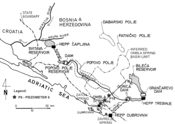
Fig. 4. The map with designated state boundary between Croatia and Bosnia and Herzegovina, reservoirs and HEPP-s of hydrotech-nical system constructed on the Trebiˇsnjica River catchment, three piezometers (P9, P6, P18), and karst springs near the Ombla Spring.
totaling 9832 m length and two pipelines. The first tunnel and pipeline from the Pranˇcevi´ci Reservoir, with discharge of 120 m3/s started to operate in 1962, while the second (100 m3/s) began in 1980. After the first tunnel and pipeline were brought into function, the mean annual discharges on the Cetina River downstream of the Pranˇcevi´ci Reservoir de-creased from about 100 to about 40 m3/s. After the second pipeline was put into operation, the mean annual discharges dropped to less than 10 m3/s or about 10% of the natural dis-charge.
In the 1960s, when the volume of ecologically acceptable flow of 8 m3/s that had to be released from the Pranˇcevi´ci Reservoir was agreed upon, there was no environmental awareness in this area. In fact, supply of even such a low vol-ume was disregarded. Although environmental awareness al-tered significantly in the 1980s there were no changes in sys-tem management. It is hard to determine the extent and type of the resulting environmental and other damages. The basic problem is the lack of data on the initial state of the ecosys-tem before the Zakuˇcac HEPP was constructed and put into operation.
3.3 Problems caused by Salakovac Reservoir operation This example demonstrates the negative effects of what is considered to be a successful engineering undertaking in the central part of the Dinaric karst in Bosnia and Herzegov-ina. Construction of the Salakovac Reservoir on the Neretva River resulted in the flooding of three karst springs on the left bank and three karst springs on the right bank. They now function as swallow-holes (Bonacci and Jelin, 1988). All the water that was lost through them appeared about 1 km down-stream from the dam in a group of springs. Most of these springs were, in natural state, only temporary, and during dry seasons their aggregate discharge was approximately 1 m3/s.
Fig. 5. Photograph of canalization of the Trebiˇsnjica River water-course by building a concrete canal.
The first filling of the Salakovac Reservoir at the beginning of 1982 gave a dramatic demonstration of how new hydroge-ologic conditions can quickly change water circulation in the karst area. The discharge of the downstream springs is now 28 m3/s at times of maximum water levels in the reservoir. The mean discharges of the Neretva River at the dam site is 183 m3/s. Two attempts at remedial works reduced water losses from the reservoir to 22 m3/s.
On the right side of the Neretva River canyon there is rail-way tunnel 3239.5 m in length. In the natural state its bot-tom was about 37 m higher than maximum water level of the Neretva River. After the construction of the Salakovac Reser-voir, the maximum water level was only 7 m lower than the tunnel bottom. Every intensive rainfall, which is very fre-quent in this region, then caused very rapid breakthroughs of water into the tunnel. This situation had never occurred be-fore the Salakovac Reservoir operation. During floods, traf-fic through the tunnel must be interrupted. The changes of hydrogeological regime caused by rising of the groundwater level of the karst aquifer on the right bank are responsible for this extremely hazardous condition. Very complex and expensive remedial work needs to be done.
3.4 Catastrophic flood in the Cetinje Polje
A catastrophic flood in Cetinje Polje between 16 and 20 February 1986 was highly destructive in the town of Cetinje (Serbia and Montenegro). This flood was mostly caused by groundwater discharged from the artificial access tunnel to Cetinje Cave and appearance of new karst springs on the southern margin of the polje (Boˇskovi´c and ˇZivaljevi´c, 1986; Mijatovi´c, 1987; Bonacci and ˇZivaljevi´c, 1993).
The Cetinje polje is formed by erosion at the altitude of about 650 m a.s.l. Its size is about 4 km2. The town of Cetinje occupies more than 50% of the lower part of the polje.
A
P9 P6
P18
A
0 1
2 3
4km
0.0ma.s.l. POLJES I N KARST
2.5 130 200 400 600 800
IMPERVIOUS LAYERS
IMPERVIOUS LAYERS LIMESTONE
GROUNDWATER CIRCULATION UNEDRGROUND
DAM
Legend: swalow-hole
Fig. 6. The cross-section A-A given on the Fig. 4 with designated positions of the Ombla Spring, the HEPP Ombla underground dam (in project), the location of three deep piezometers (P9, P6, P18), the state boundary between Croatia and Bosnia and Herzegovina, the Trebiˇsnjica River, and the inferred Ombla Spring basin limit.
southern wind, led to rapid melting of about 80 cm thick snow cover in the catchment. Mijatovi´c (1987) considers that karst flooding is generally due to the far smaller capacities of karst drainage systems in the endokarst (deep underground) than in (shallow) epikarst. Bonacci (1987) argues that the protection of the Cetinje town and polje from floods depends upon the capacity of the ponors. From his investigations the maximum capacity of the ponors in the polje is insufficient. Most capacity, situated in the lower part of the polje, and thus within the Cetinje urban area, is about 30 m3/s (Boˇskovi´c and
ˇ
Zivaljevi´c, 1986; Mijatovi´c, 1987). The catastrophic flood-ing drastically emphasized the role of ponors in karst water circulation. Therefore, the swallow capacity of ponors has to be constantly and carefully considered.
The catastrophic flood of February 1986 is typical example of unfortunate coincidence of natural extremes (extremely high precipitation and fast snow melting) and bad human in-tervention in the karst massif (cutting of the artificial access tunnel to Cetinje Cave in Cetinje Polje).
3.5 Regulation and canalization of the Trebiˇsnjica River Figure 3 represent the map of the South Adriatic coastal karst and the Dinaric karst of Eastern Herzegovina, with indica-tions of main artificial and natural karst phenomena. Fig-ure 4 shows state boundary line between Croatia and Bosnia and Herzegovina, and indicate the reservoirs and HEPPs of a hydroelectrical system constructed in the Trebiˇsnjica River catchment. This area, of about 5000 km2, is part of the deep and bare Dinaric karst. The population is concentrated in several poljes in the karst and in towns along the Adriatic Sea coast.
The Trebiˇsnjica River from the Gorica Dam to the dam at the end of the Popovo Polje is 65 km in length, and rep-resents a perched stretch of the channel; i.e. its watercourse is 50 m and more above the groundwater table. Due to this reason there were permanent water losses underground into the karst, and during the summer season the surface flow dried up (Milanovi´c, 1981). The water losses ranged from 40 to 70 m3/s. In 1978 the 65 km of the watercourse of the
0
0 1 2 3 4 5 6 7 8
50 100 150 200
130
P9 P6 P18
PIEZOMETERS
MAX. GW L
MIN. GWL
L [km] - DISTANCE 1 3 0 m a.s.l.
~165 m a.s.l.
135 m a.s.l.
75 m a.s.l.
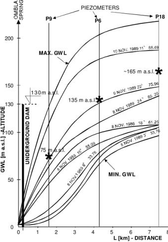
Fig. 7. Ombla catchment groundwater levels on cross-section A-A given on Fig. 4 with designated position and elevation of un-derground dam and altitudes when starts overflow from the Ombla Spring catchment to neighboring karst springs catchments.
Trebiˇsnjica River was regulated and canalized by building a concrete canal with a discharge capacity of 45 m3/s (see Fig. 5).
There are very complex karst underground connections be-tween the Trebiˇsnjica River, and the Ombla Spring aquifers (see Figs. 3, 4 and 6). The canalization caused a de-crease of the average annual discharge of the Spring from 30 to 22 m3/s, although significant changes in the minimum and maximum annual discharges were not noticed (Bonacci, 1995). Overall works on the Trebiˇsnjica River catchment and watercourse have strongly altered groundwater circula-tion and influenced redistribucircula-tion of the karst catchment ar-eas in the region.
The effects of 65 km long canalization of the Trebiˇsnjica River, and other human interventions, on the regional envi-ronment are not investigated well enough, especially their negative consequences on regional biological diversity and on surviving of endangered, endemic karst species.
3.6 The Ombla underground HEPP
Figure 4 shows the locations of Ombla Spring, three deep piezometers (P9, P6 and P18), the state boundary line be-tween Croatia and Bosnia and Herzegovina, Trebiˇsnjica River and inferred Ombla Spring basin limit. Figure 6 shows the cross-section A-A of Fig. 4 with the Ombla HEPP under-ground dam (projected).
The intention of all the detailed, long lasting and expen-sive, investigations, which are being conducted within the Ombla HEPP project, is to determine whether or not the idea of forming an underground storage basin by building an un-derground dam in the hinterland of the Ombla karst Spring can be realized.
The Ombla Spring is an abundant ascending karst spring with an average discharge of 22 m3/s. The minimum dis-charge is about 4 m3/s and the maximum discharge slightly exceeds 100 m3/s. Its exact catchment area has not been de-termined, although numerous investigations and groundwa-ter tracings have been carried out; it is estimated to cover be-tween 800 and 900 km2. Figure 4 shows inferred basin limit in accordance with hydrogeological investigations. There are two permanent karst springs (Zaton and Zavrelje on Figs. 3 and 4) and a few karst springs which dry up. Analyses have shown (Bonacci, 1995; Bonacci and Roje-Bonacci, 2000) that they all are connected to the Ombla Spring catchment. When high groundwater levels of the Ombla aquifer result in discharge exceeding 70 m3/s at the Spring, the groundwa-ter overflows into the catchments and aquifers of these other springs.
Figure 7 shows a cross-section from the Ombla Spring through piezometers P9, P6 and P18. This cross-section is designated as A-A on Figs. 4 and 6. Figure 7 also presents some simultaneously measured groundwater levels, outflow discharges at the Ombla Spring and position and elevation of underground dam (the projected elevation is 130 m a.s.l.). The most important information in all three piezometers is the groundwater levels at which water starts to overflow from the Ombla Spring catchment to neighboring karst springs catchments: 75 m a.s.l., 135 m a.s.l., and 165 m a.s.l. on piezometers P9, P6 and P18, respectively. This means that construction of so high underground dam will cause con-tinuously overflow of groundwater from the Ombla Spring catchment to other springs. Some intermittent karst springs will become permanent and many other unpredictable and possibly dangerous changes in karst groundwater circulation should be expected. Occurrence of landslides, and danger-ous environmental changes are very probable. This dam will change definitely the characteristics of regional karst aquifers and environment. Finally, a further possible problem that should be stressed is that the Ombla HEPP will use ground-water from internationally shared karst aquifer.
3.7 An earthquake in Southern Croatia and Western Herze-govina
At 17:19 LT on 23 May 2004 there was an earthquake of 5.5◦on the Richter scale with the epicenter on the boundary
between Southern Croatia and Western Herzegovina (Site 7,
Fig. 2). This was a strong earthquake that it caused rapid, but mostly short-lived, changes in the hydrogeological regime of the region. The water levels in all karst rivers in the region quickly decreased by 60–180 cm, and flow from some per-manent karst springs dried up. After about 10 h hydrological situation at the surface returned at the state as it was before the earthquake. Unfortunately there was no information on changes in the karst underground. The same situation occurs after each earthquake in the region. Very often earthquakes cause the collapse of dolines.
4 Conclusions
Natural and anthropogenic changes in karst regions fre-quently cause redistribution in karst catchments, which strongly, suddenly and dangerously affects processes of wa-ter circulation at the local or regional scale. Generally these changes are unforeseeable, unexpected and with hazardous consequences. Occurrence of landslides, floods, collapse of dolines, regional water redistribution, drying up of karst springs, conflicts on internationally shared aquifers etc. can be caused. Seven examples are given in this paper. Some of them are caused by natural processes, while others by hu-mans. In the future it is realistic to expect new and greater human interventions in karst areas. All existing structures on karst were built with the same objective, i.e. to improve the water regime and the living conditions in the region. Past experience has shown that many of these works have been suboptimal. The benefit resulting in one area was frequently smaller than damage caused in another area. Caution in seed-ing, preparation, and fulfillment of them should be extremely high.
Karst catchments and aquifers display the extreme het-erogeneity, variability and vulnerability of their hydrologic, hydrogeologic, hydraulic, ecological and other parameters, in time and space. Such complex systems need interdisci-plinary co-operation among numerous experts in the broad field of karstology. A first and essential step is to create the aquifer characteristics, the catchment areas and parameters of their water budgets. It should be based on detailed and continuous monitoring of many different hydrogeological, hydrological, geophysical and chemical parameters. To build good and safe structures on karst, and in the same time to identify and protect vulnerable karst environment should be the main aim, of the experts.
Edited by: M. Parise
References
Bakalowicz, M.: G´eochimie des eaux karstique et karstification, Annal. de Speleol., 30, 4, 581–589, 1975.
Bonacci, O.: Karst hydrology with special reference to Dinaric karst, Springer Verlag, Berlin, 1987.
Bonacci, O.: Ground water behaviour in karst: example of the Ombla Spring (Croatia), J. of Hydrol., 165, 113–134, 1995. Bonacci , O.: Analysis of the maximum discharge of karst springs,
Hydrogeol. J., 9, 328–338, 2001.
Bonacci, O.: Development of catchment area in karst as a result of natural and anthropological factors, in: Evolution of karst from prekarst to cessation, edited by Grabovˇsek, F., Inˇstitut za Raziskovanje Krasa, Postojna, 345–367, 2002.
Bonacci, O. and Jelin, J.: Identification of a karst hydrological sys-tem in the Dinaric karst (Yugoslavia), Hydrol. Sci. J., 33, 5, 483– 497, 1988.
Bonacci, O. and Roje-Bonacci, T.: Heterogeneity of hydrologic and hydrogeologic parameters in karst: example from Dinaric karst, Hydrol. Proc., 14, 2423–2438, 2000.
Bonacci, O. and Roje-Bonacci, T.: The influence of hydroelectri-cal development on the flow regime of the karstic river Cetina, Hydrol. Proc., 17, 1–15, 2003.
Bonacci, O. and ˇZivaljevi´c, R.: Hydrological explanation of the
flow in karst: example of the Crnojevi´ca spring, J. of Hydrol., 146, 405–419, 1993.
Boˇskovi´c, M. and ˇZivaljevi´c, R.: Hidroloˇski osvrt na poplavu
Cetinja od 18. do 20.02.1986, (Hydrologic review of the 1986 Cetinje flood), Vodoprivreda, 18, 102–103, 259–264, 1986. Breznik, M.: Storage reservoirs and deep wells in karst regions,
Balkema, Rotterdam, 1998.
Csepregi, A.: Computer simulation of the karstwater table in the Transdanubian mountain ranges, Hungary, in: Karst waters and environmental impacts, edited by Gunay, G. and Johnson, I., Balkema, Rotterdam, 343–352, 1997.
Choppy, J.: La tectonique et la karst, Proc. of 12th Int. Cong. of
Speleol., La Chaux de Fonds, 1, 367–368, 1997.
Dreybrodt, W.: Processes in karst systems: physics, chemistry and geology, Springer Verlag, Berlin, 1988.
Dreybrodt, W. and Siemers, J.: Early evolution of karst aquifers in limestone: models on two dimensional percolation clusters. Proc.
12thInt. Cong. of Speleol., La Chaux de Fonds, 2, 75–80, 1997.
Ford, D. C. and Williams, P. W.: Karst geomorphology and hydrol-ogy, Unwin Hyman, London, 1989.
Mijatovi´c, B.: Catastrophic flood in the polje of Cetinje in February 1986, a typical example of the environmental impact of karst, Proceed. of the sec. multidisciplinary conf. on sinkholes and the environm. impacts of karst, Orlando, Balkema, Rotterdam, 299– 303, 1987.
Milanovi´c, P. T.: Karst hydrogeology, Water Resources Publica-tions, Littleton, 1981.