Jianyu Xu , Bing Zhang , Minghuan Wang , and Huijuan Wang
1Wuhan Institute of Heavy Rain, China Meteorological Administration, Wuhan, China 2Weather Modification Office of Hubei Province, Wuhan, China
Correspondence to:Jianyu Xu ([email protected])
Received: 31 December 2011 – Revised: 6 September 2012 – Accepted: 15 October 2012 – Published: 8 November 2012
Abstract.In this study, the Weather Research and Forecast-ing model was used to simulate the diurnal variation in sum-mer precipitation over the Tibetan Plateau (TP) at a cloud-resolving scale. Compared with the TRMM, precipitation data shows that the model can well simulate the diurnal rain-fall cycle with an overall late-afternoon maximum precipi-tation in the central TP and a nighttime maximum in the southern edge. The simulated diurnal variations in regional circulation and thermodynamics are in good correspondence with the precipitation diurnal cycles in the central and south-ern edge of TP, respectively. A possible mechanism responsi-ble for the nocturnal precipitation maximum in the southern edge has been proposed, indicating the importance of the TP in regulating the regional circulation and precipitation. Keywords. Meteorology and atmospheric dynamics (Pre-cipitation)
1 Introduction
The Tibetan Plateau (TP) has crucial influences on the Asian monsoon climate and global climate system. In summer, the TP is a huge elevated heating source (Yanai et al., 1992) that exerts a significant effect on the atmospheric motion. Krishnamurti and Kishtawal (2000) have pointed out that continental-scale circulation changes can be observed in the upper troposphere over the TP in summer.
Numerous studies (e.g., Dai, 2001; Nesbitt and Zipser, 2003; Hirose and Nakamura, 2005) have demonstrated that summer precipitation over land regions has significant diur-nal variation and usually reaches the maximum in the late-afternoon. However, topography, land-sea contrast, surface heterogeneity, convection propagation and other factors can
cause different regions to have varying diurnal character-istics. In general, the diurnal variation in precipitation is closely related to the diurnal variation in circulation. How-ever, there are relatively few studies on the diurnal varia-tion in circulavaria-tion (Chow and Chan, 2009). With its com-plex topography and substantial surface inhomogeneity, the TP may have unique diurnal variations in regional circulation and precipitation.
The pioneer numerical simulation of the diurnal cycle over the TP has been carried out by Kuo and Qian (1981) us-ing a coarse resolution “dry” model (no precipitation) with only five vertical levels. Different physical fields are shown to have significant diurnal variations. Based on an evaluation of reanalysis data at 00:00 and 12:00 UTC, Yanai et al. (1992) as well as Yanai and Li (1994) have found that vertical mo-tion, surface temperature and convection have significant di-urnal variations over the TP in summer. The convective ac-tivity is strong at 12:00 UTC and weak at 00:00 UTC. Recent studies using field observations, radar data and satellite data have confirmed these results (e.g., Liu et al., 2002; Bhatt and Nakamura, 2005; Fujinami et al., 2005).
Fig. 1.Nested model domains and topography (m) of the simula-tion.
the TP in spring using a mesoscale model. They suggest that finer resolutions less than 7 km are necessary to simulate the realistic phase.
Based on the observations of Liu et al. (2009), the present study investigated the capability of a cloud-resolving model (CRM) in simulating the diurnal variation in summer pre-cipitation over the TP. The high-resolution simulation by the CRM is used to explore the dynamics of the diurnal cycle in TP regions with complex topographies and heterogeneous land surfaces.
2 Model and numerical simulation
The Weather Research and Forecasting (WRF) model ver-sion 3.3 developed by the National Center for Atmospheric Research was used in the present study (Klemp et al., 2007). The WRF model is a fully compressible nonhydrostatic model, and uses the Arakawa C grid for horizontal and terrain-following hydrostatic-pressure vertical coordinates.
The configurations used in numerical simulation had two nested domains of 15 and 3 km grid spacings (Fig. 1). D1 had 288×180 grid points and D2 had 1101×626 grid points.
The simulation used 31 vertical levels. The Rapid Radia-tive Transfer Model (RRTM) longwave radiation scheme (Mlawer et al., 1997), Dudhia shortwave radiation scheme (Dudhia, 1989), WRF Single-Moment 6-class (WSM6) mi-crophysics scheme (Hong and Lim, 2006), and the Unified Noah Land Surface Model (Chen and Dudhia, 2001) were used for this simulation. The Kain–Fritsch (new Eta) (Kain, 2004) cumulus parameterization scheme was used in D1, and explicit convection was used in D2 (3 km resolution). The re-sults from D2 were used for analysis.
The initial and boundary conditions were derived from Na-tional Centers for Environmental Prediction (NCEP) 1◦× 1◦
reanalysis data. The simulation started at 00:00 UTC, 25 June 2003 and ended at 00:00 UTC, 1 August 2003. Eight
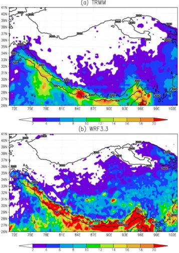
Fig. 2.Precipitation (mm day−1)averaged in July 2003:(a)TRMM
data,(b)model simulation. Solid lines indicate the 3000 and 500 m topographies, respectively.
outputs from 00:00 UTC to 21:00 UTC were generated each day at 3 h intervals. Only simulation results in July 2003 were analysed (the first 6 days of simulation were consid-ered as the model spin-up time). TRMM 3B42 data, which have a 0.25◦
×0.25◦
resolution and outputs at 3 h intervals from 00:00 UTC to 21:00 UTC, were used for verification.
3 Analytical method
Harmonic analysis (Roy and Balling, 2005) was used to examine the diurnal time series of 3 h-accumulated rain-fall averaged in July 2003 (the measurable precipitation de-fined was>0.02 mm h−1for the simulated precipitation and
TRMM observation (Zhou et al., 2008).
P =P+
N/2
X
i=1
Aicos
i2π t
N −ϕi
,
whereP andP are the precipitation and corresponding daily mean, respectively,N=8 is the number of total daily
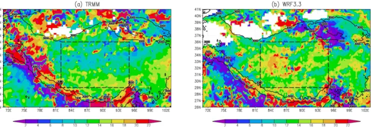
Fig. 3.Phase (UTC) of the diurnal harmonic of 3 h rainfall:(a)TRMM data,(b)model simulation. Solid lines indicate the 3000 and 500 m topographies, respectively. The dashed rectangles represent the central plateau.
Fig. 4.Diurnal variation in precipitation (mm h−1)averaged over:(a)the central plateau,(b)the southern edge.
Ai andϕi are the amplitude and phase of thei-th harmonic mode, respectively. The calculated ϕ1 is the timing of the
maximum.
4 Results
4.1 Diurnal variation in precipitation
Figure 2 shows the mean precipitation in July 2003. The pre-cipitation descends northward (Fig. 2a). The rainfall amount is over 10 mm day−1in the southern edge of TP, but it is only
about 2 mm day−1in the southeast plateau. In the vast areas
of the northwest TP and the Qaidam Basin, the precipitation is less than 2 mm day−1. The primary features are well
sim-ulated, including the precipitation pattern and heavy rainfall
areas (Fig. 2b). However, compared with the TRMM obser-vation, the simulated precipitation is a bit large overall. Other meteorological variables, such as the wind vector and geopo-tential height, are also well simulated (not shown).
The phase of the diurnal harmonic of 3 h rainfall in Fig. 3a indicates that the occurrence of the maximum precipita-tion has salient geographical dependence. Overall, the maxi-mum precipitation in the central TP mostly occurs at around 12:00 UTC, equivalent to late-afternoon/evening local solar time (LST), whereas a nocturnal maximum prevails during 18:00–24:00 UTC (00:00–06:00 LST) at around the plateau periphery. The main characteristics are well captured by the simulation (Fig. 3b). Nevertheless, the simulated maximum occurs 4 h later than the TRMM data in some regions in the central western plateau, such as Ngari Sanai (84◦
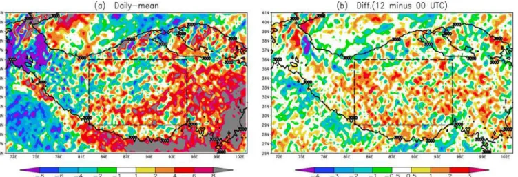
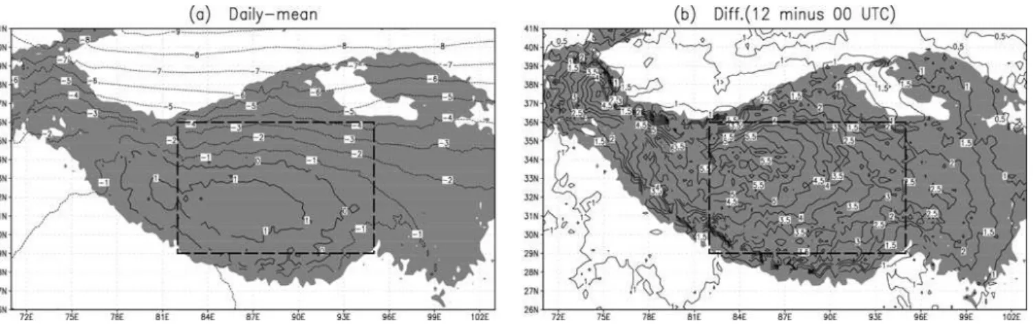
Fig. 5.500 hPa streamline:(a)daily-mean,(b)difference between 12:00 and 00:00 UTC. The shaded areas are above 3000 m and the dashed rectangles represent the central plateau.
Fig. 6.250 hPa divergence:(a)daily mean (×10−6s−1),(b)difference (×10−5s−1)between 12:00 and 00:00 UTC. Solid lines indicate the
3000 m topography. The dashed rectangles represent the central plateau.
probably due to the simulation results being limited by very complex topography. The drought in this area may confer difficulty in detecting precipitation using satellites. In addi-tion, the simulated amplitude of the diurnal harmonic is also comparable with the observations (figure not shown).
The simulated precipitation in the northern TP is too small to reach the measurable precipitation (Fig. 3b). Therefore, focus is mainly given on the central and southern edge of the TP. Figure 4a presents the diurnal precipitation variation averaged over the central TP (82–95◦
E, 29–36◦
N). A strik-ing diurnal variation can be seen from the TRMM data, with the minimum at 03:00 UTC, a subsequent rapid increase, the maximum at 09:00–12:00 UTC, and a slow weakening throughout the night. The model can capture well the precip-itation diurnal cycle. However, the simulated magnitude is about twice as large as the TRMM data. The nocturnal maxi-mum precipitation along the southern edge is also reasonably reproduced in the simulation (Fig. 4b). Similarly, the precip-itation is overestimated. Possible mechanism to explain the
nocturnal maximum in precipitation will be discussed in the following Sect. 4.4.
4.2 Diurnal variation in circulation and thermodynamics
Fig. 7.500 hPa temperature (◦C):
(a)daily-mean,(b)difference between 12:00 and 00:00 UTC. The shaded areas are above 3000 m, and the dashed rectangles represent the central plateau.
Fig. 8.450 hPa water vapour mixing ratio (g kg−1):(a)daily mean,(b)difference between 12:00 and 00:00 UTC. Solid lines indicate the
3000 m topography. The dashed rectangles represent the central plateau.
divergence favour summer convection in the TP, and its en-hancement in the late-afternoon relative to early morning in the central TP corresponds well with the precipitation diur-nal cycle in the area. In contrast, the opposite flow diurdiur-nal cycle in the southern edge of the TP matches the nighttime maximum precipitation.
In summer, the TP is a huge elevated heating source (Fig. 7a) with the warmest centred in the central southern plateau. The temperature in the central part is about 4◦
C higher at 12:00 UTC than 00:00 UTC (Fig. 7b), which is beneficial to convection development. Figure 8a presents the mean water vapour mixing ratio at the 450 hPa level. The centre of moisture is located in the south and decreases to-ward the north. In the central part, the enhanced late-day tro-pospheric humidity is favourable to convection development and rainfall production, and the opposite is true in the south-ern edge of the TP (Fig. 8b).
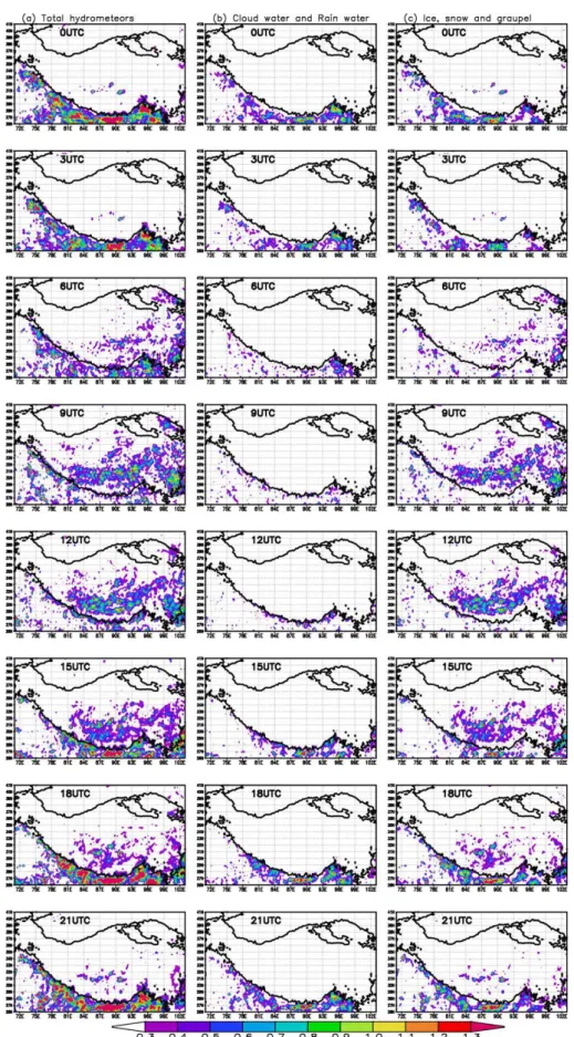
4.3 Diurnal variation in total hydrometeors
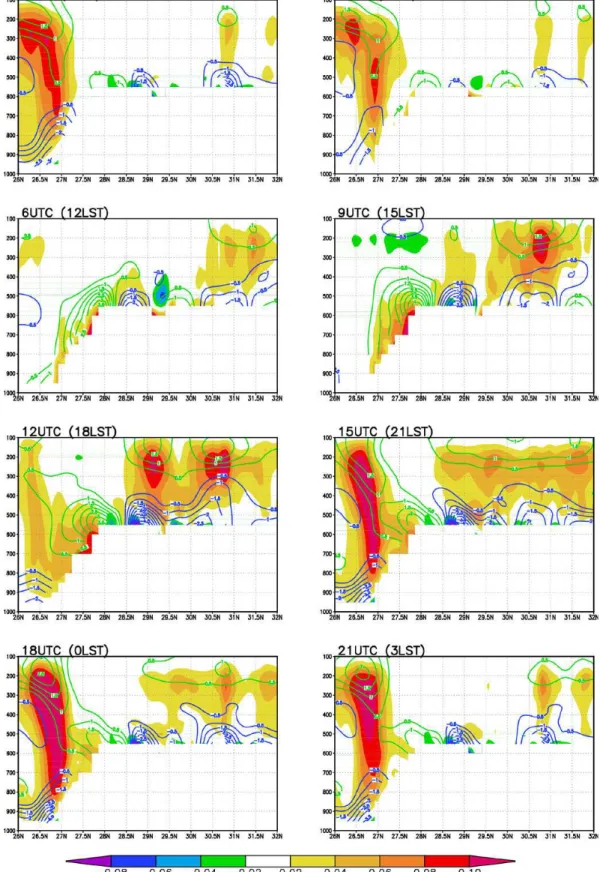
Fig. 10.Latitude-pressure cross-section averaged over 88◦–92◦E for vertical velocity (shaded, m s−1) and the divergence (contoured,
Fig. 12.Latitude-pressure cross-section averaged over 88◦–92◦E for vertical velocity (shaded, m s−1), and the vertical circulation vectors
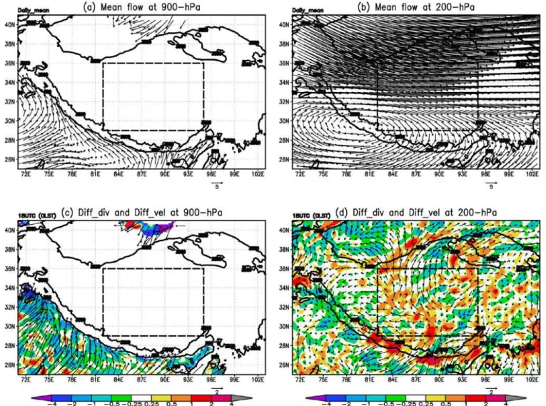
Fig. 13.Daily-mean velocity field (vectors) at levels:(a)900 hPa,(b)200 hPa; Diurnal variations (18:00 UTC minus daily mean) of diver-gence (×10−5s−1, shadings) and velocity field (vectors) at levels:(c)900 hPa,(d)200 hPa.
4.4 Possible mechanism responsible for the nocturnal precipitation maximum over the southern edge of TP
Figure 10 shows a latitude-pressure cross-section of the ver-tical velocity averaged over 88◦
–92◦
E. In the day time, the surface over the TP is heated by the sun. At 06:00 UTC (12:00 LST), upward motion can be observed over the TP. This upward motion increases and reaches the maximum at 12:00 UTC (the precipitation at this time is the largest) along with the stronger surface heating. After the sunset, the up-ward motion over the TP decreases gradually and almost dis-appears at 00:00–03:00 UTC.
The Hovm¨oller diagram of the rain-rate (Fig. 11) indicates that the maximum precipitation at the lower part of the south-ern slope of the TP is separated from the precipitation in the north. Further, there is no downslope flow at the southern slope of the TP in the simulation results (Fig. 12). So the
In this study, we investigated the diurnal variation in summer precipitation over the TP using the WRF model version 3.3 at a resolution of 3 km. The numerical simulation was per-formed in July 2003 by NCEP reanalysis boundary forcing. Compared with the TRMM precipitation data, the model can well simulate the primary features of precipitation diurnal cy-cle in summer over the region. The maximum precipitation occurs mostly in the late-afternoon in the central plateau and usually at night in the southern edge. The simulated rainfall is about twice as large as the TRMM observation, which may be related to the horizontal resolution used in this simulation (Sato et al., 2008). A higher resolution should be considered if the computing resources are sufficient. The physical pro-cesses in the model are also far from faultless (e.g., Liu et al., 2011), leading to imperfect simulation results. Physical pro-cesses suitable for the TP need to be developed by increasing the frequency of observations over the region.
Diurnal variations in regional circulation and thermody-namic fields reflect the importance of the TP in the adjust-ment of regional circulation and precipitation. In the cen-tral plateau, the air has strong lower-level convergence and upper-level divergence in the late-afternoon compared with early morning. Meanwhile, the air is warmer and more hu-mid, which is conducive to the development of convection. The maximum precipitation also occurs at this time. In con-trast, the reversed-flow diurnal cycle in the southern edge of the TP coincides with the nocturnal preference for rainfall. Detailed analyses of the diurnal variations in the simulated vertical circulation and some factors such as mountain-valley flows, low-level nocturnal jet and upper-level northeast jet prompt to propose a new mechanism responsible for the noc-turnal maximum precipitation over the southern edge of the TP.
Acknowledgements. The authors wish to thank two anonymous re-viewers whose comments and suggestions greatly enhanced the quality of this paper. This research was jointly supported by the National Natural Science Foundation of China under Grant Nos. 41105073, 41075038, and 41175016.
Topical Editor P. M. Ruti thanks two anonymous referees for their help in evaluating this paper.
summer, Clim. Dynam., 32, 55–73, 2009.
Dai, A.: Global precipitation and thunderstorm frequencies. Part II: Diurnal variations, J. Climate, 14, 1112–1128, 2001.
Dudhia, J.: Numerical study of convection observed during the winter monsoon experiment using a mesoscale two-dimensional model, J. Atmos. Sci., 46, 3077–3107, 1989.
Fujinami, H., Nomura, S., and Yasunari, T.: Characteristics of diur-nal variations in convection and precipitation over the southern Tibetan Plateau during summer, SOLA 1, 49–52, 2005. He, H. and Zhang, F.: Diurnal variations of warm-season
precipi-tation over North China. Mon. Weather Rev., 138, 1017–1025, 2010.
Hirose, M. and Nakamura, K.: Spatial and diurnal varia-tion of precipitavaria-tion systems over Asia observed by the TRMM precipitation, J. Geophys. Res., 110, D05106, doi:10.1029/2004JD004815, 2005.
Hong, S. Y. and Lim, J. O. J.: The WRF Single-Moment 6-Class Mi-crophysics Scheme (WSM6), J. Korean Meteor. Soc., 42, 129– 151, 2006.
Kain, J. S.: The Kain-Fritsch convective parameterization: An up-date, J. Appl. Meteorol., 43, 170–181, 2004.
Klemp, J. B., Skamarock, W. C., and Dudhia, J.: Conservative split-explicit time integration methods for the compressible nonhydro-static equations, Mon. Weather Rev., 135, 2897–2913, 2007. Krishnamurti, T. N. and Kishtawal, C. M.: A pronounced
conti-nentalscale diurnal mode of the Asian summer monsoon, Mon. Weather Rev., 128, 462–473, 2000.
Kuo, H. L. and Qian, Y. F.: Influence of the Tibetan Plateau on cu-mulative and diurnal changes of weather and climate in summer, Mon. Weather Rev., 109, 2337–2356, 1981.
Liu, C., Ikeda, K., Thompson, G., Rasmussen, R., and Dudhia, J.: High-resolution simulations of wintertime precipitation in the Colorado headwaters region: sensitivity to physics parameteri-zations, Mon. Weather Rev., 139, 3533–3553, 2011.
Liu, L., Feng, J., Chu, R., Zhou, Y., and Ueno, K.: The diurnal vari-ation of precipitvari-ation in Monsoon season in the Tibetan Plateau, Adv. Atmos. Sci., 19, 365–378, 2002.
Liu, X., Bai, A., and Liu, C.: Diurnal variations of summertime pre-cipitation over the Tibetan Plateau in relation to orographically-induced regional circulations, Environ. Res. Lett., 4, 045203, doi:10.1088/1748-9326/4/4/045203, 2009.
Meinke, I., Roads, J., and Kanamitsu, M.: Evaluation of RSM-simulated precipitation during CEOP, J. Meteorol. Soc. Japan, 85A, 145–166, 2007.