www.scielo.br/rbg
MAGNETIC ANALYSIS OF ABAET´E DIAMONDIFEROUS DISTRICT (MINAS GERAIS, BRAZIL)
AND ITS POSSIBLE PRIMARY SOURCES
Gisella Magalh˜aes Silva, Issamu Endo and Maria S´ılvia Carvalho Barbosa
ABSTRACT.This work studies the origin of the diamonds from the important mining region, Abaet´e Diamondiferous District (Minas Gerais, Brazil). The discovery of pipes with micro diamonds and/or crater facies kimberlites in the entire Alto Parana´ıba Igneous Province (macro region of Abaet´e District) enhanced the interest about understanding the diamonds origins. The diamonds from this district usually show few cleavages, present more than 100 carats (ct) and are associated to numerous indicator minerals for kimberlite, suggesting proximity between their primary and current sources. In order to corroborate with the area geophysics knowledge, high resolution maps were prepared using airborne magnetic data integrated with geology and field studies. The products were used to: suggest the continental fracture zones which allowed the ascent of alkaline magma; correlate magnetic responses with stratigraphic and tectonic features; indicate the magnetic responses of the lineaments that govern the diamantiferous drainages; suggest possible kimberlite clan rocks; and estimate the basement depth by Euler Deconvolution. The crystalline basement is concave and the sedimentary rocks thickness may achieve about 3,000 m. The magnetic anomalies selected as possible kimberlite clan rocks were detailed using ground magnetic surveys and their Analytic Signal was adopted to estimate the magnetic source geometries by Euler Deconvolution. These possible kimberlitic pipes look like each other and presenting depths of up to 200 m and diameters of up to 300 m.
Keywords: mineral prospecting, Euler Deconvolution, Alto Parana´ıba Igneous Province.
RESUMO.Este trabalho estuda a origem dos diamantes de uma importante regi˜ao mineradora, o Distrito Diamant´ıfero Abaet´e (MG). A descoberta de kimberlitos com microdiamantes e/ou f´acies de cratera em toda Prov´ıncia ´Ignea do Alto Parana´ıba (macrorregi˜ao do distrito) aumentou o interesse de compreender a origem destes diamantes. Os diamantes da ´area geralmente apresentam poucas feic¸˜oes de clivagem, mais que 100 quilates (ct) e est˜ao associados aos minerais indicadores de rochas kimberl´ıticas, sugerindo proximidade entre suas fontes prim´arias e atuais. A fim de contribuir com o conhecimento geof´ısico da ´area, mapas geof´ısicos de alta resoluc¸˜ao foram confeccionados usando dados aeromagn´eticos integrados `a geologia e aos estudos de campo da regi˜ao. Os produtos desta integrac¸˜ao foram utilizados para: sugerir as zonas de fraturas continentais que permitiram a ascens˜ao magm´atica alcalina; correlacionar a magnetometria com a estratigrafia e as feic¸˜oes tectˆonicas; indicar as feic¸˜oes magn´eticas dos lineamentos que regem as drenagens diamant´ıferas; sugerir poss´ıveis rochas do clan kimberl´ıtico; e estimar a profundidade do embasamento atrav´es da Deconvoluc¸˜ao de Euler. O embasamento cristalino ´e cˆoncavo e a espessura das camadas de rochas sedimentares atinge cerca 3.000 m. As anomalias magn´eticas, selecionadas como poss´ıveis intrus˜oes kimberl´ıticas, foram detalhadas em levantamentos magn´eticos terrestres e a Deconvoluc¸˜ao de Euler foi aplicada em dados de Sinal Anal´ıtico destes levantamentos. As poss´ıveis intrus˜oes kimberl´ıticas s˜ao semelhantes entre si, apresentando n˜ao mais que 200 m de profundidade e 300 m de diˆametro.
Palavras-chave: prospecc¸˜ao mineral, Deconvoluc¸˜ao de Euler, Prov´ıncia ´Ignea do Alto Parana´ıba.
Universidade Federal de Ouro Preto, Department of Geology, School of Mines, Campus UFOP, 35400-000 Ouro Preto, MG, Brazil. Phone: +55(31) 3559-1600 – E-mails: [email protected]; [email protected]; [email protected]
i i
“main” — 2018/8/20 — 23:07 — page 524 — #2
i i
524
MAGNETIC ANALYSIS OF ABAET´E DIAMONDIFEROUS DISTRICT (MINAS GERAIS, BRAZIL) AND ITS POSSIBLE PRIMARY SOURCESINTRODUCTION
Worldwide, kimberlites and lamproites are important diamond sources (e.g. Pereira, 2007; Chaves et al., 2008). Usually the high magnetic susceptibility from pipes produces significant con-trast with the surrounding rock, and they may be mapped using the magnetic method. It is believed that magnetometry has much to contribute to the knowledge of Brazilian kimberlite provinces (e.g. Pereira, 2007).
The current geophysical study selected an extremely interest-ing gemological region and at the same time does not differ from the geological setting of the Brazilian diamondiferous regions that contain well-known kimberlitic rocks. The region chosen was Abaet´e Diamondiferous District, in the midwest of Minas Gerais State. Its geologic setting suggests proximity between primary sources and current sedimentary deposits (Pereira, 2007). This conjecture is due to important factors. Firstly numerous kimberlite pipes of commercial and scientific interest were found close to the district (Barbosa, 1991; Gonzaga & Tompkins, 1991; Costa et al., 1997; Thomaz, 2009). In this geological scenario, the Canastra-01 (in S˜ao Roque de Minas city) (Chaves et al., 2008) and X270 (near to Patos de Minas city) (Read et al., 2004) kimberlites are highlighted. The first was considered exploitable while the former presented crater facies kimberlitic, showing that not all kimberlite clan were completely eroded. Diamonds with few cleavages, gems larger than 100 ct, and the presence of abundant mineral indi-cators for kimberlite (including garnet, Cr-diopside, Mg-ilmenite and chromite and olivine) are usual in the Abaet´e Diamondiferous District. In addition, the lithosphere presents a favorable environ-ment for crystallization of diamonds which favor the existence of undiscovered diamondiferous intrusions (Pereira & Fuck, 2005; Pereira, 2007).
GEOLOGICAL CONTEXT
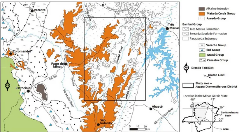
The Abaet´e Diamondiferous District is located on the east of the southwestern border of the Sanfranciscana Basin (Alkmim & Martins-Neto, 2001; Alkmim, 2004) (Fig. 1). The district con-sists of three visible groups: Bambu´ı, Areado and Mata da Corda (Sgarbi et al., 2001). The Bambu´ı Group is constituted of pelites and carbonates passing to conglomerates and sandstones at the borders and at the top (Alkmim, 2004). The associations of sili-ciclastic and biochemical lithofacies were deposited in an ex-tensive epicontinental sea during the Neoproterozoic (Iglesias & Uhlein, 2009). The Cretaceous Areado Group is subdivided into three Formations: Abaet´e, Quiric´o and Trˆes Barras designating basal conglomerates, lacustrine pelites and sandstones,
respec-tively. The Mata da Corda Group is composed by the Patos and the Capacete Formations. The first consists of complexes of al-kaline volcanic rocks and the second is composed by pyroclastic rocks, lavas and intrusive rocks reworked from the Patos Forma-tion, also during the Cretaceous (Sgarbi et al., 2001). The Areado Group sits in erosive and angular discordance over the Neopro-terozoic rocks. During the Cretaceous, the basaltic flows of the Paran´a Basin and the opening of the South Atlantic Ocean mod-ified the crustal balance and by isostatic compensation, the up-lift of Alto Parana´ıba Arc. Fracture zones where kimberlite clans intruded are associated with uplift of this arc. It is believed that the kimberlites ascended in a fast geological event between Lower and Upper Cretaceous (Read et al., 2004), dating predominantly from 89-120 Ma (Sgarbi et al., 2001).
METHODOLOGY
The airborne magnetic data sets used were provided by Compa-nhia de Desenvolvimento de Minas Gerais (CODEMIG) and are part of Minas Gerais State Aerogeophysics Survey Program – 2005/2006. The Abaet´e Diamondiferous District is included in Area 7 (Patos de Minas-Arax´a-Divin´opolis) and also in Area 9 (Jo˜ao Pinheiro-Presidente Oleg´ario-Tiros) (Lasa, 2007a,b). They surveys include N-S production lines separated by 0.4 km and E-W control lines distant from 8.0 km from each other. The average flight height was around 100 m, and the instrument cesium vapor magnetometer with 0.01 nT nominal precision was used. The in-tervals between the geophysical measurements were 0.05 s and 0.10 s and the magnetic datums were 23386 nT (at 02/14/2007) and 23368 nT (at 06/23/2006), respectively, Area 7 and Area 9 (for more details see Lasa, 2007a,b).
The reprocessing of the airborne surveys was initiated by leveling (and micro-leveling) the datasets to a common base. Afterwards, a set of maps including Anomalous Magnetic Field Map, First and Second Vertical Derivative Maps, and Analyti-cal Signal Map were generated and analyzed. Geology and field studies (as search wells and collect of the indicator minerals for kimberlite) were incorporated into the analysis. As a result, some magnetic anomalies were chosen and detailed with ground magnetic surveys.
All magnetic detail surveys had lines oriented in N-S direction spaced of 100 m. Along these lines the samples were collected at 10 m intervals. Samples for the diurnal variation correction were collected each 1 h and there were resampling daily of 2 stations to support the validation of ground databases. The solar radiation intensity was monitored daily by the site
Figure 1 – The study area, Abaet´e Diamondiferous District (Minas Gerais, Brazil), is located on the east of the Bras´ılia Fold Belt, Sanfranciscana Basin (adapted from
Heineck et al., 2003).
http://www.ngdc.noaa.gov. Even with the previous knowledge of the behavior of Earth’s magnetic field the records were analyzed, processed and validated at the end of each workday. The ground magnetic surveys were processed leveling all data, subtracting the IGRF and diurnal variation. The same set maps of the airborne databases was generated.
The inversion of magnetic data was made using the Analyt-ical Signal. It is an efficient technique to determination of geo-metrical parameters, such as boundaries between magnetic and non-magnetic rocks by Euler Deconvolution. The Euler Deconvo-lution also infers the depth of source from the surface position and geophysical anomaly (Durrheim & Cooper, 1998). It was adopted structural index equal to 1 for planar structures, estimated depth for display the responses of the 3500 m inversion and the win-dow size 11 (dimensionless unit – for more details see Durrheim & Cooper, 1998). Each profile infers the magnetic source depth as a cut (one slice) and the interpolation of many bidirectional profiles integrated to geological data, enable the understanding of the magnetic source geometries (for more details see Madeira et al., 2015).
The parameters adopted to generate the two-dimensional profiles to estimate the magnetic source depth was started with the creation of E-W profiles (perpendicular to magnetic data). The
spacing between them was one kilometer for the airborne surveys and 20 m for the ground surveys.
RESULTS AND DISCUSSION
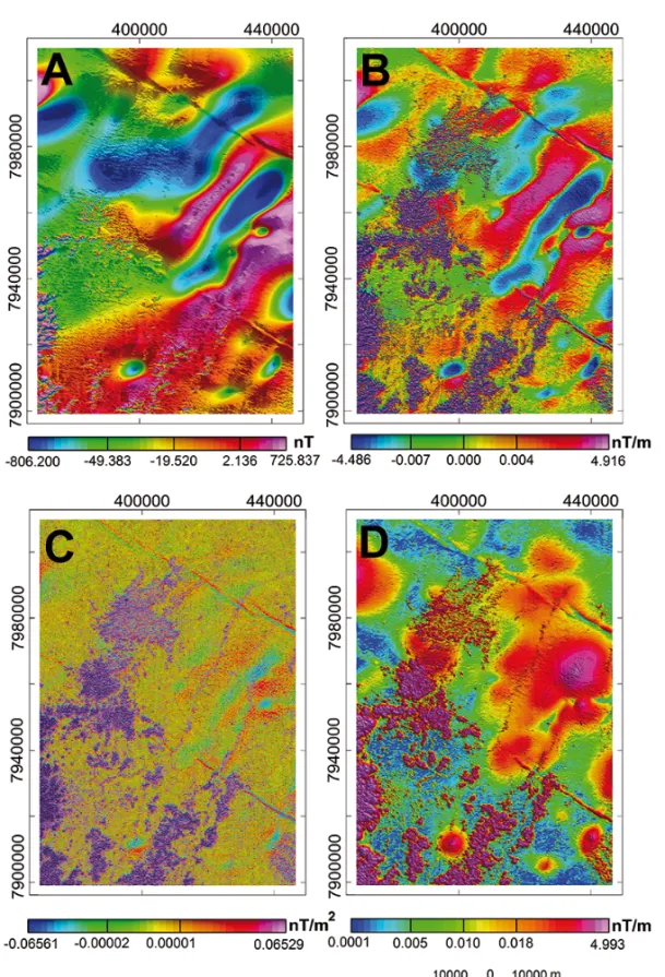
The first results presented were the reprocessed magnetic maps using airborne surveys. Initially, the area was divided into two dis-tinct domains based on its frequency content: a high frequency domain related to shallow sources and a low frequency domain related to deeper sources (Figs. 2 and 3).
First Vertical Derivative Map was selected for the graphi-cal representation of the main magnetic anomalies and diamond drainages (Fig. 3). High frequencies responses are overlapped on very low frequency responses suggesting a large interval be-tween them. It can be interpreted as the existence of a magnetized substrate, a large package of non-magnetic rocks and as well as magnetic rocks very close to the surface. The correlation to the airborne magnetic data and the regional geology (Sgarbi et al., 2001; Heineck et al., 2003; Read et al., 2004) suggest that high frequency anomalies arise from the mafic alkaline and ultramafic rocks of the Cretaceous Mata da Corda Group. Since the Areado and Bambu´ı groups do not contribute to the magnetic response, the low frequency anomalies should belong to structures of the crystalline basement (magnetic background).
i i
“main” — 2018/8/20 — 23:07 — page 526 — #4
i i
526
MAGNETIC ANALYSIS OF ABAET´E DIAMONDIFEROUS DISTRICT (MINAS GERAIS, BRAZIL) AND ITS POSSIBLE PRIMARY SOURCESFigure 2 – (A) Anomalous Magnetic Field Map; (B) First Vertical Derivative Map; (C) Second Vertical Derivative Map and (D) Analytical Signal Map.
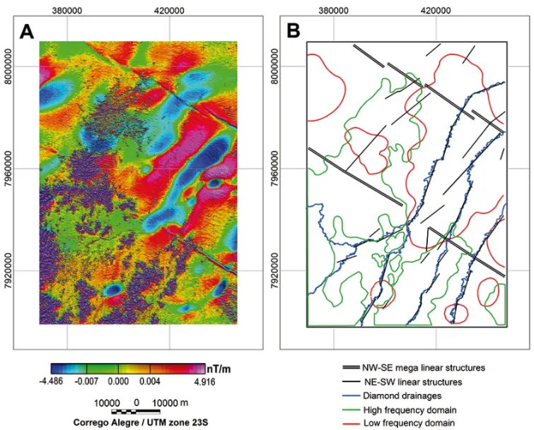
The NW-SE liners (Fig. 3) are the mega structural lineaments named 125th AZ (Gonzaga & Tompkins, 1991; Hasui &
Hara-lyi, 1991). The main feature of the NE-SW lineaments inside the Abaet´e Diamondiferous District is its intrinsic relation to the structural control of the diamond drainages. Pereira (2007) calls
attention to the importance of these linear structures in the prospection in (and around) diamondiferous kimberlites in the S˜ao Francisco Craton.
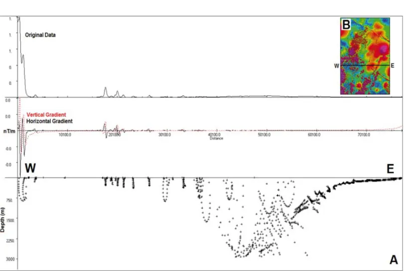
Euler results are presented as crosses (+) in two-dimensional profiles and account for the roof depth of magnetic source (Fig. 4).
Figure 3 – (A) First Vertical Derivative Map and (B) graphical representation of the main magnetic anomalies and diamond drainages.
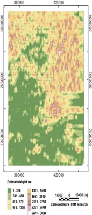
If only the magnetic maps were analyzed, it would be possi-ble to imagine that the high magnetic values, in the low frequency domain, arise from some geologic high structural. However, the results of two-dimensional deconvolution profiles suggest the sedimentary rocks thickness may achieve 3000 m (Fig. 5). These results agree with those from the seismic and the borehole studied by Romeiro-Silva & Zal´an (2005) and high magnetic susceptibil-ity could be generated by mineralogical variations of the base-ment S˜ao Francisco Craton. Who proposed that the basebase-ment of Sub-Basin Abaet´e can be deeper than 3,000 m. In addition, they also suggested that the western boundary S˜ao Francisco Craton in subsurface is further west (under of Bras´ılia Fold Belt). Due to this, Pereira (2007) proposed that the NW-SE linear structural features (Fig. 3) break up areas where the Archean basement was preserved in midwest of Minas Gerais State.
According to Pereira (2007) the district has high potential for diamond-bearing kimberlites. Agreeing with his proposition, some magnetic responses integrated with the geology and studies
field were selected as possible primary sources and their located are shown in the Analytical Signal Map (Fig. 6). These areas were detailed by the ground magnetometer surveys and their Analytic Signal was adopted to estimate the possible magnetic source ge-ometries as airborne survey. The results of two-dimensional de-convolution profiles of the magnetic source number 1 (Fig. 6) is shown in the Figure 7.
Euler Deconvolution responses suggest that the magnetic responses selected as possible kimberlitic clan intrusions are similar. They are near surface, presenting depths of up to 200 m and diameters of up to 300 m (Fig. 7).
CONCLUSIONS
Airborne magnetic data was used to comprehend that nowadays, the main diamond drainages of the district are seated on NE-SW lineaments. However, in the past, the rivers could have been on other NE-SW lineaments too. This is useful information in order to propose mining areas far from current drainages. Euler
Deconvo-i i
“main” — 2018/8/20 — 23:07 — page 528 — #6
i i
528
MAGNETIC ANALYSIS OF ABAET´E DIAMONDIFEROUS DISTRICT (MINAS GERAIS, BRAZIL) AND ITS POSSIBLE PRIMARY SOURCESFigure 4 – (A) Estimated depth profile of the magnetic sources by Euler Deconvolution and (B) Analytical Signal Map with the location of the profile.
lution responses confirm that the district is divided into two mag-netics domains: shallow sources related to Mata da Corda Group, as well as possible kimberlitic clan rocks and deeper sources re-lated to basement. It is suggested that the basement would be concave and presenting depths of up to 3,000 m. Understand-ing how the Craton basement is really important to figure out the geological setting during the raise of the kimberlitic clan. Espe-cially when comprehending in which areas these igneous rocks were able to bring gems. Fortunately, the Abaet´e Diamondifer-ous District (Minas Gerais) exhibits favorable conditions for it. Ground magnetic surveys were integrated with geology and stud-ies field (including search wells and collect of the indicator miner-als for kimberlite) to build up this theory. Although the magnetic source geometries being similar each other presenting depths of up to 200 m and diameters of up to 300 m, other sorts of pipes can be find out into the district. These possible primary sources are near 125th AZ lineaments and many indicator minerals for
kimberlites as garnet, diopside, and olivine are easily find. They are inside a mining area where there are giant gems (over than 100 ct) and diamonds displaying few transport are recurrently discovered. These evidences corroborate with the theory that Abaet´e Diamondiferous District (MG) can be diamond-bearing kimberlites, including in commercial scale.
ACKNOWLEDGEMENTS
The authors thank Companhia de Desenvolvimento Econˆomico de Minas Gerais (CODEMIG) for the permition of use of the airborne magnetic data; company GAR Minerac¸˜ao Com´ercio e Exportac¸˜ao Ltda. for allowing the access to their research reports and for the collaboration of its researchers; Conselho Nacional de De-senvolvimento Cient´ıfico e Tecnol´ogico (CNPq), Coordenac¸˜ao de Aperfeic¸oamento de Pessoal de N´ıvel Superior (Capes) and Pro-grama de P´os-Graduac¸˜ao em Evoluc¸˜ao Crustal e Recursos Natu-rais, Universidade Federal de Ouro Preto, for funding and infras-tructure.
REFERENCES
ALKMIM FF. 2004. O que faz de um cr´aton um cr´aton? O Cr´aton do S˜ao Francisco e as Revelac¸˜oes Almeidianas ao Delimit´a-lo. In: MANTESSO-NETO V, BARTORELLI A, CARNEIRO CDR & BRITO NEVES BB (Org.). Geologia do Continente Sul-Americano: Evoluc¸˜ao da Obra de Fernando Fl´avio Marques Almeida. S˜ao Paulo, Brazil, Beca, p. 17–35.
ALKMIM FF & MARTINS-NETO MA. 2001. A Bacia Intracratˆonica do S˜ao Francisco: Arcabouc¸o estrutural e cen´arios evolutivos. In: PINTO CP & MARTINS-NETO MA (Eds.). Bacia do S˜ao Francisco: Geologia e Recur-sos Naturais. SBG/MG, p. 9–30.
Figure 5 – Spatial positioning of the Euler solutions presenting the geologic
compartmentation of the area.
BARBOSA O. 1991. Diamante no Brasil: hist´orico, ocorrˆencia, prospec-c¸˜ao e lavra. Bras´ılia, Brazil, CPRM. 136 pp.
CHAVES MLSC, ANDRADE KW, BENITEZ L & BRAND˜AO PRG. 2008. Prov´ıncia Diamant´ıfera da Serra da Canastra e o kimberlito Canastra-1: Primeira fonte prim´aria de diamantes economicamente vi´avel do pa´ıs. UNESP, Geociˆencias, 27(3): 299–317.
COSTA VS, FIGUEIREDO BR & WESKA RK. 1997. Estudos mineral´o-gicos e qu´ımicos do kimberlito Batovi 6 (MT) em comparac¸˜ao com as intrus˜oes Trˆes Ranchos 4 (GO) e Limeira 1 (MG). Rev. Geochimica Brasiliensis, 11(1): 53–71.
DURRHEIM RJ & COOPER GRJ. 1998. EULDEP: A program for the Eu-ler Deconvolution of magnetic and gravity data. Elsevier – Computer & Geosciences, 24(6): 545–550.
GONZAGA GM & TOMPKINS LA. 1991. Geologia do Diamante. In: SCHOBBENHAUS C, QUEIROZ ET & COELHO CE (Eds.). Princi-pais Dep´ositos Minerais do Brasil, Gemas e Rochas Ornamentais. DNPM/CPRM. Volume IV, Parte A.
HASUI Y & HARALYI NLE. 1991. Aspectos lito-estruturais e geof´ısicos do soerguimento do Alto Parana´ıba. Bol. Geoc., 10: 57–77.
HEINECK CA, LEITE CAS, SILVA MA & VIERA VS. 2003. Mapa Geol´o-gico do Estado de Minas Gerais, 1:1.000.000. Belo Horizonte, Brazil, Convˆenio COMIG/CPRM.
IGLESIAS M & UHLEIN A. 2009. Estratigrafia do Grupo Bambu´ı e cober-turas faneroz´oicas no vale do rio S˜ao Francisco, norte de Minas Gerais. Rev. Bras. Geoc., 39(2): 256–266.
i i
“main” — 2018/8/20 — 23:07 — page 530 — #8
i i
530
MAGNETIC ANALYSIS OF ABAET´E DIAMONDIFEROUS DISTRICT (MINAS GERAIS, BRAZIL) AND ITS POSSIBLE PRIMARY SOURCESFigure 6 – Ground survey areas selected as possible kimberlitic clan rocks.
Figure 7 – Result of two-dimensional deconvolution profiles presenting one possible kimberlitic clan intrusion (ground survey number 1).
LASA ENGENHARIA E PROSPECC¸˜OES S.A. 2007a. Relat´orio Final do Levantamento e Processamento dos Dados Magnetom´etricos e Gama-espectrom´etricos. ´Area 7 – Patos de Minas-Arax´a-Divin´opolis. Levan-tamento Aerogeof´ısico de Minas Gerais. Secretaria de Estado de Desen-volvimento Econˆomico de Minas Gerais (SEDE), Brazil. 224 pp.
LASA ENGENHARIA E PROSPECC¸˜OES S.A. 2007b. Relat´orio Final do Levantamento e Processamento dos Dados Magnetom´etricos e Gama-espectrom´etricos. ´Area 9 – Jo˜ao Pinheiro-Presidente Oleg´ario-Tiros. Levantamento Aerogeof´ısico de Minas Gerais. Secretaria de Estado de Desenvolvimento Econˆomico de Minas Gerais (SEDE), Brazil. 121 pp.
MADEIRA TJA, BARBOSA MSC & BORGES AJ. 2015. Interpretation of magnetic data based on Euler Deconvolution: Analysis of the main host gold structure in the northeastern portion of the Quadril´atero Ferr´ıfero, MG, Brazil. Brazilian Journal of Geophysics, 33(3): 431–444. PEREIRA RS. 2007. Cr´aton do S˜ao Francisco, kimberlitos e diamantes. Doctorate Thesis on Geophysics – Instituto de Geociˆencias, Universidade de Bras´ılia, Brazil, 200 pp.
PEREIRA RS & FUCK RA. 2005. Archean Nucleii and the distribution of kimberlite and related rocks in S˜ao Francisco Craton, Brazil. Rev. Bras. Geoc., 35(3): 93–104.
READ G, GRUTTER H, WINTER S, LUCKMAN N, GAUNT F & THOMSEN F. 2004. Stratigraphic relations, kimberlite emplacement and lithospheric thermal evolution, Quirico Basin, Minas Gerais State, Brazil. Lithos, 77:
803–818.
ROMEIRO-SILVA PC & ZAL´AN PV 2005. Contribuic¸˜ao da s´ısmica de re-flex˜ao na determinac¸˜ao do limite oeste do Cr´aton do S˜ao Francisco. In: Simp´osio Cr´aton do S˜ao Francisco, 3., 2005, Salvador, Brazil. Proceed-ings, 44–47.
SGARBI GNC, SGARBI PB DE A, CAMPOS JEG, DARDENNE MA & PENHA UC. 2001. Bacia Sanfranciscana: O registro Faneroz´oico da Ba-cia do S˜ao Francisco. In: PINTO CP & MARTINS-NETO MA (Eds.). BaBa-cia do S˜ao Francisco: Geologia e Recursos Naturais. SBG/MG, p. 93–138. THOMAZ LV. 2009. Estudo petrogr´afico e qu´ımica mineral da intrus˜ao kimberl´ıtica R´egis, no oeste de Minas Gerais. Master Dissertation on Geophysics – Instituto de Geociˆencias, Universidade de S˜ao Paulo, Brazil, 2009. 143 pp.
Recebido em 23 setembro, 2014 / Aceito em 23 fevereiro, 2017 Received on September 23, 2014 / Accepted on February 23, 2017