www.scielo.br/rbg
ANALYSIS OF SEAFLOOR DEPTH ANOMALIES BETWEEN THE ASCENSION AND
ST. HELENA ISLANDS, SOUTH ATLANTIC
Marisa Makler
1,2and Sidney Luiz de Matos Mello
1Recebido em 23 marc¸o, 2006 / Aceito em 26 abril, 2007 Received on March 23, 2006 / Accepted on April 26, 2007
ABSTRACT.Observed seafloor depths from 12 kHz bathymetry coupled with seafloor spreading magnetic anomalies were used to obtain depth anomalies across the Mid-Atlantic ridge axis between 2◦S and 18◦S. The theoretical seafloor depths were calculated from the plate cooling model and crustal ages depicted from seafloor spreading magnetic anomalies between 0 to 25 Ma. We noticed that the seafloor spreading magnetic anomalies are symmetric with respect to the ridge axis between Ascension and St. Helena Islands, but the depth anomalies are quite asymmetric. The east side of the ridge axis is shallower (∼1,000 meters) than the west side, probably as a result of a thermal upwelling of the lithosphere. We suggest that a mantle plume located on the African Plate, which could represent a larger swell linked to Ascension, St. Helena and Fernando P´o-Annobon Volcanic Lineament, might cause this type of anomaly.
Keywords: depth anomalies, magnetic anomalies, Ascension Island, St. Helena Island, South Atlantic.
RESUMO.Dados de batimetria de 12 kHz e anomalias magn´eticas do fundo oceˆanico foram empregados para calcular anomalias de profundidades na cordilheira mesoceˆanica entre as Ilhas de Ascens˜ao e St. Helena. A profundidade te´orica do fundo oceˆanico foi calculada com base no modelo de resfriamento de placas litosf´ericas e a idade crustal, considerando as anomalias magn´eticas de expans˜ao do fundo oceˆanico entre 0 e 25 Ma. Notamos que as anomalias magn´eticas de expans˜ao do fundo oceˆanico s˜ao sim´etricas em relac¸˜ao ao eixo da cordilheira entre as Ilhas de Ascens˜ao e St. Helena. No entanto, as anomalias de profundidade s˜ao assim´etricas com ao eixo da cordilheira. O lado leste da cordilheira ´e mais elevado (∼1.000 metros) do que o lado oeste, refletindo provavelmente uma subida da estrutura termal da litosfera sob esta regi˜ao. Por esta raz˜ao, sugerimos a existˆencia de uma pluma do manto localizada na Placa Africana, a qual se estenderia por uma grande regi˜ao, envolvendo os complexos vulcˆanicos de Ascens˜ao, St. Helena e Fernando P´o-Annobon e causaria uma elevac¸˜ao na estrutura termal da litosfera.
Palavras-chave: anomalias de profundidade, anomalias magn´eticas, Ilha de Ascens˜ao, Ilha de St. Helena, Atlˆantico Sul.
1Universidade Federal Fluminense, Departamento de Geologia – LAGEMAR, Av. Litorˆanea s/n, sala 407, Gragoat´a, 24210-340 Niter´oi, RJ, Brasil. Tel.: (21) 2629-5924; Fax: (21) 2629-5931 – E-mail: [email protected]
108
ANALYSIS OF SEAFLOOR DEPTH ANOMALIES BETWEEN THE ASCENSION AND ST. HELENA ISLANDS, SOUTH ATLANTICINTRODUCTION
According to the plate tectonics model the new oceanic litho-sphere is formed at the spreading center along the mid-ocean ridges (e.g., Le Pichon, 1968). The upper layer of the oceanic crust generates seafloor spreading magnetic type anomalies that act as a magnetic tape recorder of the Earth’s magnetic field as new crust is formed at the ridge axis (Vine, 1966). Thus, Heirtzler et al. (1968) showed that the age of the oceanic crust can be determined from seafloor spreading magnetic type anomalies.
Once it is formed the young oceanic lithosphere becomes col-der and subsides as it moves away from the spreading center. It contracts and thus increases in density. Therefore, if we as-sume the oceanic regions to be compensated, the depth of the oceans should increase with increasing age (and thus plate den-sity). For any model of the cooling lithosphere, the expected ocean depth can be calculated. Parsons and Sclater (1977) and many others (e.g., Stein & Stein, 1992; Johnson & Carlson, 1992; and Doin & Fleitout, 1996) showed that the age of the oceanic crust can be used to derive theoretical seafloor depths from the cooling plate model. The parameters involved are determined by fitting a theoretical depth-age curve to empirical depth-age data believed to best represent the basin-wide thermal state of the lithosphere. Their simple model assumes a linear relation between the sea-floor depth and the square root of crustal age, and, also between the heat flow and the inverse of the square root of the crustal age. Sclater et al. (1971) showed an empirical relation between heat flow and seafloor depth and the age of the oceanic crust.
Thus, the theoretical seafloor depths can be calculated from the age of the oceanic crust and used to indicate oceanic regions that agree or not with the cooling plate model. The seafloor depth anomalies, which mark the difference between the theoretical and observed seafloor depths, can be an indicative of the thickening of the oceanic crust due intense volcanism and/or of the location of the lithospheric thermal anomalies due to hotspots.
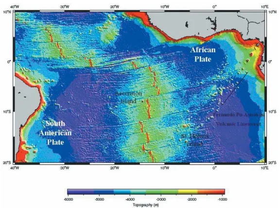
This paper examines the depth anomalies between the As-cension and St. Helena Islands (Fig. 1), which has been argued as a long ridge segment influenced by a ridge centered hotspot (e.g., Mello, 1993; Bruguier et al., 2003; Minshull et al., 2003). There are topographic and geochemical evidences that support a hotspot location in the region: (a) the existence of an anoma-lous topographic high at the ridge axis (e.g., Brozena, 1986) and (b) the isotopic spikes in the La/Sm, Nd/Zn and Sr/Nd ratios in basalts dredged around 10oS (e.g., Schilling et al., 1985; Fon-tignie & Schilling, 1996). However, there are strong geophysical evidences, such as: (a) an anomalous crustal thickness due to
intense mantle upwelling underneath the region (e.g., Minshull et al., 1998) and/or (b) a large geographical extension of the hot-spot. Thus, this work will focus on the analysis of the seafloor depth anomalies in the region to characterize the existence and extension of thermal anomalies between the Ascension and St. Helena Islands.
Data set
The bathymetric data from the GEODAS (GEOphysical DAta Sys-tem) were used as observed seafloor depths. The GEODAS is an interactive database system developed by the National Geophysi-cal Data Center (NGDC), which contains bathymetric (including multibeam), magnetic, gravity and seismic navigation data col-lected worldwide during marine cruises from 1953 to the present. Data sources include US, foreign oceanographic institutions and government agencies. Data quality depends on the accuracy of navigation systems, which is generally good from the 70´s.
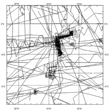
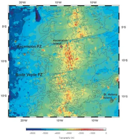
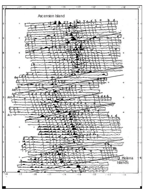
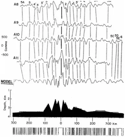
Figure 2 displays the GEODAS bathymetric track lines be-tween the Ascension and St. Helena Islands. Ship surveys cover the region with more frequency in the interesting area, providing bathymetric data for generating 5 minutes grids and contour map (Fig. 3) all from standard GMT programs (Wessel & Smith, 1998). The magnetic anomalies obtained from aeromagnetic surveys performed by the Naval Research Laboratory (NRL) during the Centratlan Project (Brozena, 1986) were used to depict the age of the oceanic crust (Fig. 4a). The synthetic magnetic model by Mello (1993) was handy to match the observed seafloor spreading magnetic type anomalies (Fig. 4b). He used the geomagnetic time scale published by Cande & Kent (1995), assuming a magnetic layer of 1 km with a standard magnetization of 0.02 emu/cm3at the ridge axis. Thus, the magnetic lineations in Figure 4a repre-sent, in fact, a given seafloor age (t) that was used to calculate the theoretical seafloor depths.
Calculation of theoretical seafloor depths and seafloor depths anomalies
The theoretical seafloor depth (d) from Parsons & Sclater (1977) assumes that the ridge axis is infinity in the y direction and the temperature of the plate is constant in the same direction. Thus, the theoretical seafloor depth is calculated by the following equation:
d=dr + 2ρaα Ta
(ρa−ρw)
kt
π
where ρa is the density of the asthenosphere (3.3× 10³ kg
m-3),ρ
Figure 1– Location of the study area showing the location of the spreading axis (red line), as well as Ascension and St. Helena Islands and Fernando P´o-Annobon Volcanic Lineament in the South Atlantic. Bathymetric map based on ETOPO2 data, National Geophysical Data Center (NGDC).
thermal expansion coefficient (3×10⁻⁵C-1),kis the diffusivity (10-6m2s-1),T
ais the temperature of the base of the lithosphere
(1200◦C) anddr is the average water depth at the ridge axis (2.5 km), which was assumed empirically observing the depths of the mid-ocean ridge crests throughout the globe.
Thus,
d =2.5+0.33√t
wheredis in km and the seafloor age (t) in Ma.
The theoretical seafloor depth (d) was calculated for each age (t) from the magnetic lineations in Figure 4a. These data provi-ded a 5 minute depth grid as a function of age. Subtracting this theoretical seafloor depth grid from the observed seafloor depth grid, we finally obtained the seafloor depth anomaly map, which is displayed in Figure 5.
Data interpretation
In Figure 3 the ridge morphology is essentially symmetric with respect to the ridge axis. The Ascension and Bode Verde frac-tures zones are the main ridge axis discontinuities within the re-gion, which display right-lateral offset of the order of tenths of
kilometers. A rift valley about 3,000-3,500 m deep is obser-ved everywhere along the ridge axis between Ascension and St. Helena Islands, but it disappears between 8◦and 10◦S, where
there is an anomalous axial high of about 2,500 m that is asso-ciated to remarkable volcanic edifices off-axis. In particular, this region is assumed to be the result of a ridge centered hotspot, somehow linked to the Ascension Island (e.g., Brozena, 1986).
The magnetic anomalies are also symmetric to the ridge axis, extending from 0 to approximately 25 Ma, as shown by magne-tic lineations in Figure 4a. Since each anomaly lineation (isoch-ron) was formed at the ridge axis, each lineation represents the former site of spreading and, therefore, shows the tectonic fra-mework along the time past. The central magnetic anomaly (zero age) fits the rift valley where it exists, while all major offsets of the central magnetic anomaly represent the ridge axis discontinuities of different orders.
co-110
ANALYSIS OF SEAFLOOR DEPTH ANOMALIES BETWEEN THE ASCENSION AND ST. HELENA ISLANDS, SOUTH ATLANTICFigure 2– Track lines of bathymetric surveys from the GEODAS database.
oling of the magnetic layer as well (e.g., Pariso & Johnson, 1993). However, Figure 5 shows that the observed seafloor depth on the African Plate is about 1,000 m shallower than theoretical seafloor depth, showing a higher topography over several hundred of ki-lometers, which do not fit the theoretical curve.
Figure 5 also shows a striking asymmetry in depths. The east side of the ridge axis is shallower than the west on the order of 1,000 m. This extends beyond the seamounts on the east side of the ridge, causing a large depth anomaly, probably associated to off-axis hotspot. In fact, this anomaly could be linked to a further south depth anomaly around the region of St. Helena Island. If it is so, Ascension and St. Helena Island as well as many volcanic edifices within this region, including the ridge axis, can be a result of a mantle swell that extends for many kilometers up to the Fer-nando P´o-Annobon Volcanic Lineament near the African Margin, as we see in Figure 6.
CONCLUSIONS
The formation of a new oceanic lithosphere is usually modelled as a symmetric process with respect to the spreading axis. But, the thermal structure of the lithosphere underneath the African Plate is distinct from the South American Plate around the Ascension and St. Helena Islands (Fig. 6). The shallower depth anomalies observed on the east side of the ridge axis between the Ascension
and St. Helena Islands is an evidence of an off-ridge axis hotspot located on the African Plate (Figs. 5 and 6). This hotspot may actually represent a topographic swell due to a deep mantle ano-malous source, which extends to the south to St. Helena and to the east to the African Margin. Rocks collected at the ridge axis between Ascension and St. Helena Islands result from a plume type mantle (e.g., Fontignie & Schilling, 1996). Geochemical de-tailed rock analysis of Ascension region and St. Helena should prove a close origin of the mantle source and the same origin of the topographic swell.
Further study on the depths anomalies over a wider region in the South Atlantic is also suggested in the light of South Pacific studies on Super Swells (e.g., Adam et al., 2005). This should contribute to examine depth anomalies in South Atlantic as well as mantle plumes.
ACKNOWLEDGMENTS
Figure 3– Observed seafloor depths shown by a coloured bathymetric map derived from 5 minute grid from the GEODAS database. Contour lines are in 1 km interval. Main islands and fracture zones are displayed.
REFERENCES
ADAM C, VIDAL V & BONNEVILLE A. 2005. A method to characterize seafloor swells with application to the south central Pacific. Geochemis-try Geophysics Geosystems, 6, Q01003, doi:10.1029/2004GC000814.
BROZENA JM. 1986. Temporal and spatial variability of seafloor spre-ading processes in the Northern South Atlantic. J. Geophys. Res., 91: 497–510.
BRUGUIER NJ, MINSHULL TA & BROZENA JM. 2003. Morphology and tectonics of the mid-Atlantic ridge,7◦−12◦S. J. Geophys. Res., 108: 2093-2115, doi:10.1029/2001JB001172.
CANDE SC & KENT DV. 1995. Revised calibration of the geomagnetic polarity timescale for the Late Cretaceous and Cenozoic. J. Geophys. Res., 100: 6093– 6095.
DOIN MP & FLEITOUT L. 1996. Thermal evolution of the oceanic litho-sphere: an alternative view. Earth Planet. Sci. Lett., 142: 121–136.
FONTIGNIE D & SCHILLING J-G. 1996. Mantle heterogeneities beneath the South Atlantic Ridge. Geophys. J. Ast. Soc., 20: 271–284.
HEITZLER JR, DICKSON GO, HERRON EM, PITMAN III WC & LePICHON X. 1968. Marine magnetic anomalies, geomagnetic field reversals, and motions of the ocean floor and continents. J. Geophys. Res., 73: 2119– 2136.
JOHNSON HP & CARLSON RL. 1992. Variation of sea floor depth with age: a test of models based on drilling results. Geophys. Res. Lett., 19: 1971–1974.
LE PICHON X. 1968. Sea-floor spreading and continental drift. J. Geo-phys. Res., 73: 3661–3697.
MELLO SLM. 1993. Marine Geology and Geophysics of the Mid Atlan-tic Ridge Between Ascension and Sta. Helena Islands. Master Disserta-tion, Universidade Federal do Rio de Janeiro/IG – Depto de Geologia, RJ, 90 pp.
MINSHULL TA, BRUGUIER NJ & BROZENA JM. 1998. Ridge-plume in-teractions or mantle heterogeneity near Ascension Island? Geology, 26: 115–118.
112
ANALYSIS OF SEAFLOOR DEPTH ANOMALIES BETWEEN THE ASCENSION AND ST. HELENA ISLANDS, SOUTH ATLANTICFigure 4a– Map of seafloor magnetic anomalies between Ascension and St. Helena Islands. Magnetic line-ations (dashed lines) are approximately in the north-south direction and parallel to the ridge axis (solid black line). Major offsets (almost east-west solid black line) represent ridge discontinuities.
of the Mid-Atlantic Ridge,8−9◦S. J. Geophys. Res., 108: 2513–2535,
doi: 10.1029/2002JB002360.
PARISO JE & JOHNSON HP. 1993. Do layer 3 rocks make a signifi-cant contribution to marine magnetic anomalies? In situ magnetization of gabbros at ocean drilling program hole 735B. J. Geophys. Res., 98: 16033–16052.
PARSONS B & SCLATER JG. 1977. An analysis of the variation of ocean floor bathymetry and heat flow with age. J. Geophys. Res., 82: 803–827.
SCHILLING J-G, THOMPSON G, KINGSLEY R & HUMPHRIS S. 1985. Hotspot-migrating ridge interaction in the South Atlantic. Nature, 313: 187–191.
SCLATER JG, ANDERSON RN & BELL ML. 1971. Elevation of ridges and evolution of the central eastern Pacific. Jour. Geophys. Res., 76: 7888–7915.
STEIN C & STEIN S. 1992. A model for the global variation in oceanic depth and heat flow with lithospheric age. Nature, 359: 123–128.
VINE FJ. 1966. Spreading of the ocean floor – New evidence. Science, 154: 1406–1415.
Figure 4b– Synthetic model by Mello (1993) used to match the observed magnetic profiles across the ridge crest segments between Ascension and St. Helena Islands.
NOTES ABOUT THE AUTHORS
Marisa Makler.Born in Niter´oi (RJ), Marisa is 24 years old with a Bachelor of Physics from Universidade Federal Fluminense (UFF). She is currently studying Marine Geology and Geophysics at LAGEMAR (Laborat´orio de Geologia e Geof´ısica Marinha). She works for Landmark/Halliburton as a member of Seismic processing Team.
114
ANALYSIS OF SEAFLOOR DEPTH ANOMALIES BETWEEN THE ASCENSION AND ST. HELENA ISLANDS, SOUTH ATLANTICFigure 5– Seafloor depth anomaly map calculated from the subtraction of the observed and theoretical seafloor depth. Main islands and fracture zones are displayed.