Keywords: GIS, GIT, morphodynamics, morphology, coastal zone
ABSTRACT: Several areas of the western coast of Portugal are undergoing severe erosion. Accurate knowledge of coastal morphology and morphodynamic characteristics as well as their correlation through time is of great importance, not only to identify coastal erosion hazards, but also to understand more in-depth the movement of sediments and the action of currents, which are the main coastal processes responsible for erosion.
The main goal of this work is to develop a tool capable of performing aerial image analysis, visual and computed, of coastal forms and wave breaking zones The results of this analysis will be integrated and made available through a GIS database. With this approach, it will be possible to typify, classify and analyse coastal physiography, and the coastline evolution, in a medium to long term period, as well as the hydromorphologies and coastal forms resulting from the wave action. The first step of this work was to store the available data into a GIS database, namely the images from the 1996 and 2001 surveys. All the surveys that don’t have coordinate systems were georeferenced using AutoCAD Map 2002 and ArcInfo 7.2.1. In parallel, a tool made with Matlab 7.0 – namely its toolbox image processing – is being developed to analyse the stored images. Also, another tool using Geographical Information Technology (GIT) is being used to perform some more aerial image analysis.
The preliminary results of this work indicate that this approach is satisfactory. The analysis system is performing well but some improvements can be introduced to the Matlab tool in order to make it able of processing imagery analysis disregarding its resolution. So far it is still unable to process high resolution images which are currently under development.
1 INTRODUCTION
A coastline represents a dynamic, fragile, physical and biological environment that is constantly changing in response to natural processes as well as human activities. It has held great attraction for man as it provides a variety of resources (i).
The coastal area in study is located on the northwestern Portuguese coast, at the Aveiro Lagoon sand spits. It is limited to the north by the city of Espinho and to the south by the Mira beach. This coastal stretch was divided in three stretches; Espinho-Furadouro; Furadouro-Torreira; and Costa Nova-Mira beach (Figure 1).
From a geomorphologic point of view, this stretch is mostly a low-lying coastal plain with sand dunes and beaches. It has a NNE-SSW general orientation, and the coastal forms present are constantly changing because of the very high hydrodynamic forces present.
The sea action regime acting in this study area is one of the most energetic worldwide, which makes the hydrodynamic forces the main coastal modelling agent.
Analysis of the Portuguese west coast morphology and
morphodynamics, based on aerial images and GIS tools
Joaquim Pais Barbosa, Fernando Veloso Gomes & Francisco Taveira PintoUniversity of Porto, Faculty of Engineering – FEUP, Hydraulics and Water Resources Institute – IHRH, Porto, Portugal; e-mail: jlpb@fe.up.pt; vgomes@fe.up.pt; fpinto@fe.up.pt
The wave climate is characterized by mean significant wave heights ranging from 2 to 3 m, with periods ranging from 8 to 12 s. In storm conditions the significant wave heights can exceed 8 m, with periods reaching 16 to 18 s. The wave direction exhibits the higher frequencies and intensities in the NW quadrant with 43.8% of occurrence, WNW with 28.0% and NNW with 21.2% (ii, iii). The littoral drifts act mainly in the north-south direction although some singular events of southeast currents can be found due to wave refraction and diffraction as a consequence of specific hydrodynamic processes. Tide range can reach up to 4.0 m for spring tides.
According to the tidal range, beaches systems can be classified morphologically as following (iv); micro-tidal (0-2 m), meso-tidal (2-4 m) and macro-tidal (> 4 m). This means that the shoreline under study can be classified as meso-tidal (2-4 m). Meso-tidal and macro-tidal beach systems have been less studied than micro-tidal ones.
Micro-tidal wave-dominated beach systems can be classified using three parameters: breaking wave height (Hb), wave period (T), and grain size (defined by sediment fall velocity, Ws). Gourlay (1968), in (v), was the first to combine these parameters into the dimensionless fall velocity by,
Ω = W THb s
(1)
Using this dimensionless relation, Gourlay found that when Ω < 1 laboratory beaches tended to be steep and stable; however when Ω > 1-2 they eroded with sediments forming a terrace attached to the beach (v).
This dimensionless relation (Ω) was adapted for natural beaches (vi). Based both on beach experiments from representative beach types, and numerous observations, they found that when Ω < 1 beaches tend to be reflective (steep, bar-less); on the opposite, when Ω > 6, beaches tend to Figure 1. Area under study.
be dissipative (flat, multi-bared); between those (Ω = 2-5) they classified beaches as intermediate (one to two bars) (v). A comprehensive range of micro-tidal beach types are illustrated in this study. Relatively to the meso and macro-tidal beach systems, (iv), macro-tidal and meso-tidal beach systems are merged in the same group, in an attempt to classify them, particularly those where tide range exceeds 3 m for average spring tides; and thus only referring to macro-tidal beaches. One major issue in the study of macro-tidal beaches is to find common paths for comparisons; these situations do not occur only in high or low sea and swell environments, with varying grain size and sorting, but also where tides range from 3 to 15 m, concerned the previous classification. Based on gradient, topography, and relative sea-swell energy, macro-tidal beaches were divided into three groups, (iv):
• Group 1 – High wave beach, planar, uniform slope; • Group 2 – Moderate wave beach, multi bar;
• Group 3 – Low wave beach and tidal flat.
As mentioned above, the knowledge of the morphodynamics of macro-tidal beaches when compared to micro-tidal beaches is very restricted, and based on a set of experiments. There is a need to conduct experiments on these systems so as to improve our understanding of the morphodynamics of the three (or more) suggested groups, as well as the critical thresholds which distinguish them from micro-tidal beaches and from tidal flats, (iv).
For the Portuguese coast there is not in general much information on the Hb and Ws parameters, being many times unavailable or simply inexistent. Hence, without knowing these parameters, the morphologic analysis of aerial images from several years, and their comparison with the coastal forms and current patterns illustrations proposed by (vi) seem to be a good approach to understand and classify beach morphologies along the Portuguese coast.
This study using aerial images analysis is expected to bring significant knowledge and an improvement on coastal morphology patterns identification regarding to the wave direction, sea bottom forms, wave heights and periods and beach profile, especially for meso-tidal beach systems. In addition it should also improve the knowledge, to better identify and typify the hydromorphologic patterns of breaking waves, sea bottom forms, currents and their relation with local wave and tide regime. All this can lead to a better understanding of the phenomena occurring at the coast, namely coastal erosion.
Aerial images were used to made comprehensive studies of coral reefs, as well as the initiation charting coastlines in Germany in 1928 and in the United States in the early 1930s (i).
An aerial image provides an excellent record of the pattern of features on a coastline at the instant the image is made. The size and spacing of waves, wave fronts and littoral drift directions, distribution of bare sand areas resulting from recent erosion or deposition, and the distribution of shallow water sediment accumulations to depths of about seven meters may easily be determined. More details of the configuration of coastal and nearshore features are discernible than are usually recorded in careful field surveys of a coastline (i).
The wave-structure/land interactions are rather complex and thus of difficult characterization. This is not only due to the existence of a dynamic action of non-linear interactions over different time scales, but also to the great difficulty to obtain long series of georeferenced data. Coastal morphodynamics are changing, either at a time scale of days (e.g. between tides) or of years (e.g. global climate change) (vii).
2 METHOD
2.1 Database
Remotely sensed data and images have been widely applied over the years to coastal environments with different degrees of success, largely dependent upon the application. Aerial images appear as a great source of information, as a result of the high resolution and spatial detail, and it is a very
important support for studies on small areas. In opposite, the satellite images offered, until recently, a poor resolution, but with a great spectral and temporal resolution and area coverage (viii).
As previously referred, there is not much knowledge of the characteristics of meso-tidal beach systems. The study described in this paper aims at improving the knowledge and understanding of meso-tidal morphology and hydrodynamics, focusing on the northwestern coast of Portugal. To accomplish this, a Geographical Information System (GIS) database is under development as well as aerial imagery analysis tools using other Geographical Information Technologies (GIT). The GIS database incorporates several types of vector (topographic surveys) and raster (aerial images) data and alphanumeric information. In addition, the data resulting from the aerial imagery analysis, from both the visual and the GIT tools analysis, are also stored in the database.
With this combination of images, GIS and GIT analysis, it is expected to identify and analyse coastal forms, wave patterns, local currents as well as sea bottom characteristics (submerged bars). The forms, patterns and local currents will be correlated with the hydrodynamic conditions especially the wave regime (period, direction and height) and the tide level. However, for some surveys the wave parameters are not available making this correlation more difficult to be achieved.
Following is a brief resume of the database development, as well as the aerial images analysis that have been carried out.
2.2 Data Acquisition and Integration
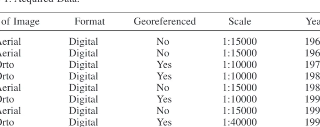
The data used to develop the GIS coastal database is diverse, from various sources, and in different supports (digital and hardcopy) (Table 1). Besides aerial imagery, vector data is also used, especially to support the georeferencing process.
Table 1. Acquired Data.
Type of Image Format Georeferenced Scale Year
Aerial Digital No 1:15000 1965
Aerial Digital No 1:15000 1967
Orto Digital Yes 1:10000 1979
Orto Digital Yes 1:10000 1988
Aerial Digital No 1:15000 1989
Orto Digital Yes 1:10000 1991
Aerial Digital No 1:15000 1992
Orto Digital Yes 1:40000 1995
Aerial Hardcopy No 1:8000 1996
Aerial Hardcopy No 1:8000 2001
A first analysis of the data available has revealed the following major problems: • Some aerial image surveys do not cover all the three stretches;
• Data with different or non-existing coordinate systems; • Images control points with errors from 100 to 200 m;
• Parameters of flight and photographic camera are unknotted available or unknown.
The images in hardcopy format (from the 1996 and 2001 surveys) were scanned, a process which can introduce sources of error affecting the imagery used. Once completed this scanning process, the data was divided into two classes, whether it was georeferenced or not. The ones that were not, had to be georeferenced using AutoCad Map 2002 and ArcInfo 7.2.1. The georeferencing process consisted of common points identification on the photogrametric surveys of 1996 and 2001 and of images. Finishing the georeferencing process all data was compared with other georeferenced ones for validation.
2.3 Analysis
Using one aerial image from each of the years 1995, 1996, 2001 and 2003, a first approach using the GIS tool analysis was presented (vii). Some important considerations could be withdrawn from the preliminary results achieved.
The former analysis, designated hereafter as visual, was extended to the three whole stretches in which the coastal stretch in analysis was divided into and has encompassed all surveys available (Table 1). Such visual analysis consisted of the identification of patterns of the longshore and rip currents; and the observation and vectorization of coastline shapes in accordance with the run-up line, the cusps and mega-cusps, the dune cliffs, and the submerged bars that are noticed in the images; whenever possible, the limit of sediment dispersion was also identified.
One of the main goals of this analysis is to establish some correlation between such morphodynamic elements and the wave climate, tide level and sediment movement patterns.
In addition, a geometric analysis was also made; this analysis consisted of measurements of the morphological forms, such as the length and width of cusps and mega-cusps, the distance between the groups of cusps and mega-cusps, the length of rip current groups, inter alia.
Once this visual analysis procedure has been completed, it will be possible to overlap, compare and make a spatial analysis in order to determine shoreline evolution, namely in terms of the evolution of forms, eroding beaches and dunes, submerged bars, as well as changes in the rip currents.
It should be noted that all the urban areas of the stretches in study are currently defended against wave action by groins and sea walls. However, even with coastal defences there are several communities at high risk of erosion. Hence, in parallel to the morphological analysis, it will also be analysed human development along the coast, focusing especially on recently built-up areas.
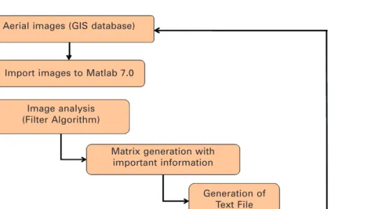
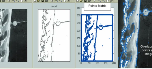
Another type of analysis, designated by computed analysis, was developed. One of those, designated by Wave IDentification (WID), is a Matlab 7.0 algorithm that mainly uses the toolbox image processing. Following its designation strictly, this tool permits to compute wave crests, wave breaking areas and some coastal forms. Figure 2 resumes the structure of WCDBA.
Figure 2. Structure of the matlab analysis tool.
Aerial images (GIS database)
Import images to Matlab 7.0
Image analysis (Filter Algorithm)
Matrix generation with important information
Generation of Text File
Export text file to a GIS Database
To achieve this goal, an existing matlab algorithm was modified. Its concept is based on matlab filters able to perform image analysis. These filters identify and create a boundary in the image where the values of colour change considerably. The pixels with such value are converted to a matrix and transformed to another one of points with coordinates (x,y). Finally, the former matrix
is converted to an ASCII file, which can be overlapped with other information existing in GIS database.
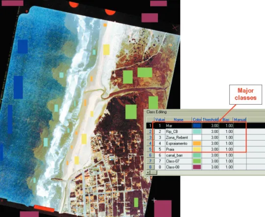
The other analysis is based on the image colours for each region that was, designated as Coulour Based Classification (CBC). For this task a remote sensing software was used. The image is first imported and classified. To accomplish it, it was necessary to create a new session configuration: editing new channels; select the training and output areas. Figure 3 shows a view of a training site, on which 5 major classes were considered.
Figure 3. Major classes editing in the training site.
The following step was to classify the image based on the training sites selection, using a algorithm named Maximum Likelihood. The achieved results will be presented forward in this text. However, it can be stressed that this analysis seems to work well for colour images, but not so well for the black and white ones.
3 RESULTS
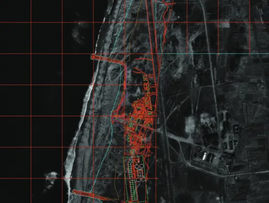
As previously mentioned, once georeferenced the information is compared to other data for validation. The average residual error of this georeferencing process was ± 3 m. The results achieved for the 1967 survey can be observed in Figure 4.
Figure 5 presents the preliminary results concerning the visual analysis of a small part along the stretch of Espinho-Furadouro for the 1967 aerial survey. As it is possible to observe, several elements were identified in this aerial images; namely submerge bars; dune and beach cliff; cusps and mega cusps; weak “rip currents”. All these features noticeable in the images were measured and added to the GIS database.
In this database, for each of the identified elements, alphanumeric information is added to the attribute table. This information consists of the image hour, day, month, year, ID, number of elements, length, width, and other relevant information.
WID preliminary results are presented in Figure 6. From left to right, this group of images are the original aerial image, the boundary points, the matrix points with (x, y) coordinates, and the overlapping with the original image.
Figure 4. 1967 aerial survey after georeferencing.
In the overlapping image it is possible to observe that wave crests and the breaking area are easily identified, as well as some of the bigger forms. Smaller forms could not be identified.
The main constraint of this tool is not being able to process high resolution images; nevertheless, the algorithm is currently under modification in order to make it able to process imagery analysis disregarding its resolution.
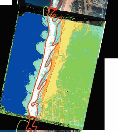
The CBC analysis preliminary results are included in Figure 7. The 5 major areas of classification can be identified by the following colours: dark blue corresponds to the sea; the light blue to the rip Figure 6. Preliminary results of matlab analysis and overlapping in GIS database.
heads; the white colour to the breaking area; the dark yellow to the run-up zone; and finally, the light yellow to the beach.
The results of this analysis were stored in the GIS database and then overlapped with the results of the visual analysis for comparison. The result of this overlapping is presented in the Figure 8.
Figure 8. Overlapping preliminary results of CBC and visual analysis.
4 CONCLUSIONS
As demonstrated throughout this paper, Geographical Information Technologies can be very helpful to observe phenomena occurring in the surf zone, whilst enabling the analysis of the morphological forms based in aerial imagery.
Following some preliminary results of a visual analysis, presented in (vii) a set of considerations were withdrawn and some forms could be identified; namely, rip currents and rip heads, which according to (iv) and (ix) have never been reported in coasts with tidal ranges higher than 3 m. Cusps, mega-cusps, submerged bars, eroding beaches and dunes were also identified.
The matlab tool has demonstrated that it could be very helpful on the identification of wave crests and wave breaking zones, despite being so far unable to process images with high resolution. With the remote sensing software analysis it was possible to classify five major areas in the present study interests; sea; rip heads; breaking zone; run-up; and beach areas. This analysis was a complement to the visual analysis because some elements already identified, such as rip heads, appeared more clearly.
When fully developed this GIS imagery database and analysis tools will be able to store comprehensive data from several years; and therefore making possible the overlap and comparison of the data resulting from the sets of image analysis, as well as the observation of coastal zone evolution, namely in matters of urban areas vulnerable to erosion hazards.
Coastal forms along the northwestern Portuguese coastal segment in analysis seem very similar when compared with the classification presented by (vi).
ACKNOWLEDGEMENTS
Professor Kazimierz Furmanczyk – University of Szczecin, ul. Waska 13, 71-415 Szczecin, Poland (kaz@sus.univ.szczecin.pl).
Luciana das Neves – University of Porto, Faculty of Engineering, Rua Dr. Roberto Frias 4200-465 Porto, Portugal (lpneves@fe.up.pt).
Portuguese Geographic Institute (IGP) Water Institute (INAG)
REFERENCES
(i) El-Ashry, M. T., 1977. Air Photography and Coastal Problems, Mohamed T. El-Ashry (ed), Dowden, Hutchinson & Ross, Inc., USA, 425 pp.
(ii) Anon., 1993. Plano de Aproveitamento da Zona entre o Molhe Sul e a Ponte-Cais No 3, Vol. 1,
Estudos de Agitação no Porto de Leixões,(in Portuguese) IHRH Report.
(iii) Anon., 2003. Eurosion Project – Guidelines for developing local information systems, Vol 1, IHRH Report.
(iv) Short, A. D., 1991. Macro-meso Tidal Beach Morphodynamics – An Overview. Journal of Coastal
Research, Vol 7, No 2: 417-436.
(v) Short, A. D., 1999. Wave-Dominated Beaches, in: Andrew Short, (ed), Handbook of Beach and Shoreface Morphodynamics, John Wiley & Sons, LTD, pp. 173-229.
(vi) Wright, L. D. & Short, A. D., 1984. Morphodynamic Variability of Surf Zones and Beaches: A Synthesis. Marine Geology, 56: 93-118.
(vii) Pais-Barbosa, J., Veloso-Gomes, F. & Taveira-Pinto, F., 2003. Indicators of a GIS-based Aerial Images Analysis of the Portuguese Northwest Coastal Dynamics. In: Fifth International Symposium on GIS
and Computer Cartography for Coastal Zone Management, Integrating Information in Coastal Zone Management.
(viii) Green, David R. & King Stephen, D., 2002. Remote Sensing and Imagery for Coastal Environments, URISA, United States.
(ix) Morang, A. & Parson, L., 2002. Coastal Morphodynamics. in: Coastal Engineering Manual, Chapter IV-3, US Army Corps of Engineers, Washington.
