CE, NE Brazil due to regional environmental changes between 1958 and 2004
Luiz Drude de Lacerda1,2, Marcelo Oliveira Teles de Menezes1 & Maurício Mussi Molisani1
Biota Neotropica v7 (n3) – http://www.biotaneotropica.org.br/v7n3/pt/abstract?article+bn00807032007
Data Received 05/03/07 Revised 17/08/07 Accepted 01/09/07
1Laboratório de Biogeoquímica Costeira, Instituto de Ciências do Mar,
Universidade Federal do Ceará, Av. abolição, 3207, CEP 60165-081, Fortaleza, CE, Brazil 2Autor para correspondência: Luiz Drude de Lacerda, e-mail: [email protected]
Abstract
Lacerda, L. D., Menezes, M.O.T. & Molisani, M.M. Changes in mangrove extension at the Pacoti River estuary, CE, NE Brazil due to regional environmental changes between 1958 and 2004.Biota Neotrop. Sep/Dez 2007 vol. 7, no. 3 http://www.biotaneotropica.org.br/v7n3/pt/abstract?article+bn00807032007. ISSN 1676-0603.
Regional land use changes at the Pacoti River basin, Ceará State, NE Brazil resulted in doubling the mangrove area from 1958 (0.71 km2) to 2004 (1.44 km2). Most of the increase was due to the replacing of salt marsh vegetation inland, but also along newly formed islands and enlarged river banks. Drastic reduction in freshwater supply and sediment accumulation due to river damming were probably the major drivers of the increased mangrove cover. However, changes due to global climate changes can not be ruled out.
Keywords: mangroves growth, regional changes, estuary.
Resumo
Lacerda, L. D., Menezes, M.O.T. and Molisani, M.M. Alteração na cobertura de manguezais ao longo do estuário do Rio Pacoti, CE, NE do Brasil devido a mudanças ambientais entre 1958 e 2004. Biota Neotrop. Sep/Dez 2007 vol. 7, no. 3 http://www.biotaneotropica.org.br/v7n3/pt/abstract?article+bn00807032007. ISSN 1676-0603
Mudanças regionais no uso da terra no estuário do Rio Pacoti, Estado do Ceará, NE do Brasil resultaram em um aumento de duas vezes na área original de manguezais presente neste estuário entre 1958 (0,71 km2) e 2004 (1,44 km2). A maior parte desta expansão ocorreu através da colonização de áreas anteriormente cobertas por vegetação de salgado, mas também ao longo de praias alargadas do rio e em ilhas recém formadas. A diminuição do fluxo de água doce e a acumulação de sedimentos devidos à construção de barragens foram as principais causas deste aumento, embora alterações resultantes de mudanças climáticas globais não possam ser descartadas.
Introduction
The northeastern Brazilian coast is a semi-arid sector of the country’s littoral where watershed management has resulted in intense environmental changes. River damming and water withdraw for hu-man use and agriculture have resulted in decreasing freshwater and sediment supply to the coastal zone. More recently, an accelerated development of tourism and shrimp aquaculture have also resulted in significant changes in the coastline. Erosion of seaward mangrove fringes, increasing saline intrusion and increasing wind driven sand transport, resulted in significant changes in mangrove cover along that part of the Brazilian coast (Lacerda & Marins 2002, Maia & Lima 2004).
The rapid response of mangroves to regional and global envi-ronmental changes and their huge ecological importance for coastal ecology and for the millions of people dwelling along tropical coasts, makes the continuous mapping of this vegetation a fundamental tool for coastal management plans and the sustainability of coastal areas.
Mangroves grow at the land-ocean interface and are thus en-croached upon by competing land use at the coastal zone. They are also subject to impacts from catchments developments. As a result, mangroves worldwide are having their extension changed (Spalding et al. 1997). Worldwide it is well accepted that mangrove extension is decreasing mostly due to conversion to other uses, in particular aquaculture, urbanization and tourism development and effects of deteriorating environmental conditions (ITTO 2002). In many coastal sites, however, regional environmental changes have resulted in an expansion of mangrove areas. Erosion of upland soils has increased sedimentation in coastal areas of Brazil, Thailand, Bangladesh, Mozambique, Venezuela, New Zealand and Louisiana, USA, resulting in augmenting of mangrove area (Lara et al. 2002, Aizpuru et al. 2000, Perez et al. 2002, Nichols & Ellis 2002, respec-tively). Schwarz (2003) considered the possibility of global climatic changes be involved with the changes in mangrove extension. Global climate change may result in rising sea level with increasing saline intrusion and mangrove expansion inland. Although, the Brazilian coast, in general, is an area of falling sea level, many areas along the northeastern and northern coasts are witnessing sea level rise, as suggested by increasing saline intrusion (Maia & Lima, (2004) and freshwater vegetation substitution by halophytes (Lara et al. 2002). On the other hand, anthropogenic environmental impacts at the regional level may also be accelerating the impacts resulting from global climate changes, or amplifying its effects upon the mangrove (Lacerda 2002), although it is extremely difficult to distinguish the influence of climate changes from regional changes on the mangrove ecosystem. In this a case study we report on the mangrove growth at the Pacoti River, northeastern Brazil related to regional changes in land use, in particular changes in freshwater flux to the ocean and sediment balance at the estuarine region.
Methods
The Pacoti River is located in the Metropolitan Region of Fortaleza, Ceará State NE Brazil, between latitudes 3° 53’ 15’’ S and 3° 55’ 0’’ S and longitudes 38° 22’ 30’’ W and 38° 26’ 5’’ W ( Figure 1). Most of the estuary comprises the “APA do Estuário Pacoti”, an Environmental Protection Area, which hampers damage to local mangroves. Climate is tropical with average annual rainfall of about 1,200 mm, distributed in a rainy summer from February to June and dry season from July to January. Average annual temperatures range from 25 to 27° C (Oliveira 1993). Up to the earlier 1980’s the area also harbored important salt production ponds, which were created over original mangroves in the 1960’s.
The Pacoti Rivers extends along 150 km form the Baturité Mountains to the sea. Total basin area reaches 1,000 km2 and the coastal basin, downstream the last artificial reservoir of about 132 km2 (Molisani et al. 2006a).
We mapped the mangrove area from the Pacoti River from three vertical aerial photographs and one satellite image. The aerial pho-tographs were digitalized on a digitalizing table and rectified with the satellite image obtained in 2004 to 1:20.000. The resulting four digitalized images were mapped using ArcGis 9.0 software, with 1:20.000 resolution, relative to the years of 1958 (1:25.000), 1968 (1:70.000), 1999 (unknown) and a 2004 RGB SPOT-5 image (5 m; 1:20.000). We analyzed the growth pattern and measured the exten-sion of the mangrove area for each year. The images were analyzed visually using forms and size of objects, color and texture. Detailed inspecting of the area was carried on during four field trips to the area performed between 2005 and 2006 for ground truth purposes, when species distribution and general structural characteristics of mangrove stands were recorded. Also, during these trips, eventual difficulties in establishing vegetation types, such as “restingas” and other transitional vegetation were checked, and corrections applied to the maps. These filed trips were also fundamental for correcting inherent errors due to the SPOT image resolution.
In order to determine whether the reservoir cascade modify the freshwater inflow into Pacoti estuary, we calculate discharge to
Brasil
564000 566000 568000
564000 566000 568000
9574000 9576000 9576000 9574000 9576000 9576000
0 225 450 900 m
Atlantic Ocean
N
S
W E
Pacoti River Estuary
03° 54' S 38° 24 W
Figure 1. General location of the study site at the Pacoti River Estuary in Ceará State, Northeastern Brazil.
Pacoti estuary simulating the influence of an undammed basin (before 1981, when dam cascade was built) and compared those results to the estimates of discharges with reservoir retention. The discharge from the undammed basin was determined through the water discharge model based on a steady state climatic water balance; assuming that rainfall equals evapotranspiration and runoff. The methodology has recently been detailed in Molisani et al. (2006b); here we only sum-marize the methods. Input data consist of monthly precipitation and temperature obtained during ~30 years at sub-basins within the Pacoti River watershed, provided by FUNCEME (unpublished data, 2006). To obtain water discharge to Pacoti estuary, we calculated annually area-average estimates of precipitation and temperature, from which evapotranspiration (Eo), runoff ratio (Δf/r), and discharge (Q) were calculated for rainy and dry seasons. This model was also used to assess the freshwater discharge to other estuaries in the Ceará state and calibration of model prediction was performed by comparing it with available field measurements (Molisani et al. 2006a).
To simulate the freshwater discharge to the estuary with reservoir retention, we used the same procedure described above to calculate the runoff (Q) related to the sub-basin downstream of the Pacoti Reservoir (the last reservoir of the dam cascade) and sum this discharge with outflow of Pacoti Reservoir (COGERH, unpublished data).
Results and Discussion
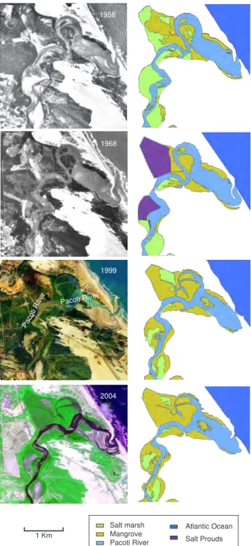
Areas of the different classification used in the interpretation of the remote images (mangroves, salt pans and slat marshes) in 1958, 1968, 1999 and 2004 are presented in Figure 2. The original mangrove area at the Pacoti River estuary in 1958 reached 0.71 km2. Salt ponds were reported to have converted mangroves during their construction in the early 1960’s and accounted for 0.69 km2 in 1968, resulting in the direct conversion of at least 0.17 km2, the remaining being built on higher marsh areas (Oliveira 1993). Therefore, during the first period analyzed in this study (1958 to 1968), mangrove cover was reduced to 0.54 km2 (Table 1).
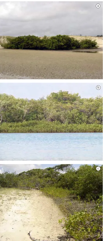
Major changes in mangrove area occurred between 1968 and 1999 mostly due to the cessation of salt production, the abandon of the salt ponds (Figure 2) and river damming. Mangrove area during this period reached 1.42 km2, resultant from the colonization of 0.56 km2 of abandoned salt ponds (Table 2). However, since most of the salt pond areas were not built on former mangroves, most of this new mangrove area (about 69%) has grown over areas formerly occupied by salt marshes and lacking mangroves in 1958. Also, an additional growth of 0.15 km2, about 21% of the original mangrove area in 1958, occurred in areas not previously occupied by salt ponds. Similarly the additional growth of 0.2 km2 verified between 1999 and 2004, also occurred in areas out of the former salt ponds (Figure 2). Thus most of the total mangrove area increase occurred by replacing higher areas formerly occupied by salt marshes, suggesting increasing saline influ-ence landward. The additional growth of mangroves occurred equally on newly formed islands (Figure 3a), along river banks (Figure 3b) and in areas previously occupied by salt marshes, but not previously converted to salt ponds (Figure 3c). Generally, Avicennia germinans was the species dominant of these newly grown mangrove stands, except the new islands, although individuals of Rhizophora mangle and Laguncularia racemosa were common within the more developed stands. Connocarpus erectus also occurred at the landward edge of the newly formed stands along river banks. Newly formed islands were preferentially colonized by L. racemosa probably due to the sandier nature of these island’s sediments. In the 31 years analyzed in the present study the mangrove area of the Pacoti River estuary doubled, increasing from 0.71 to 1.44 km2.
1958
1968
1999
2004
Pacoti River
Pacoti River
Salt marsh Mangrove Pacoti River
Atlantic Ocean
Salt Prouds 1 Km
Figure 2. Original images and ArcGis 9.0 maps of land cover features along the Pacoti River Estuary, Ceará State, NE Brazil in 1958, 1968, 1999 and 2004. Figura 2. Imagens originais e mapas em ArcGis 9.0 da cobertura do solo no estuário do rio Pacotí, Estado do Ceará, NE do Brasil em 1958, 1968, 1999 e 2004.
Table 1. Extension of the mangrove area (km2) at the Pacoti River estuary
between 1958 and 2004.
Tabela 1. Área de manguezal (km2) no estuário do rio Pacoti entre 1958 e
2004.
Year 1958 1968 1999 2004
Mangrove area 0.71 0.54 1.42 1.44
Similar mangrove colonization patterns have been reported else-where. Lara et al. (2002) reported a decrease of 36% of marsh area due to colonization by the mangrove Avicennia germinans in Bragança, Pará State, North Brazil. This drastic change in plant cover occurred in 25 year only. Colonization by A. marina and A. germinans also replaced from 50 to 75% of marshes in New Zealand and Louisiana, respectively, during the past 35 years (Schwarz 2003). In many estuaries along the Northeastern coast of Brazil the same mangrove spreading patterns is occurring (Maia et al. 2006).
Apart from the cessation of salt production, the other major land use change in the area was the building of two major dam at the Pacoti River (Pacoti and Gavião Reservoirs) to supply freshwater to the Metropolitan area of Fortaleza. Freshwater discharge, tide and waves are important controlling factors of the estuarine morphology. Thus, the accretion of sediments in river banks and the creation of islands in the Pacoti estuary, in which mangrove are growing and expanding is determined by the relative importance of fluvial versus marine forcing. Generally, sedimentation rates are inversely proportional to the freshwater inputs and larger discharges can flush sediments out of estuaries (Dyer 1985, Pontee et al. 2003). Similarly to other semi-arid river basins in Northeastern Brazil, the Pacoti River has its stream flow strongly regulated by dams. Impoundments “açudes” in Ceará State serve to supply water for human consumption and irrigation, which entails eliminating downstream discharge from dams and drastically reducing peak flows. As a result, changes on freshwater discharge to the Pacoti estuary can alter the relative importance of the fluvial end-member influencing the sedimentation rates and estuarine morphology.
Tables 3 and 4 show the meteorological and hydrological charac-teristics of the Pacoti River basin and a simulation of the freshwater discharge into the estuary. The results suggest that a 2.8 times decrease in freshwater supply is reaching the Pacoti estuary due to reservoir retention of the river flow than would be generated under undammed conditions. The dam cascade was built in 1981 which match with ma-jor changes in mangrove area occurred between 1968 and 1999. This is mostly evident during the rainy season because of the ephemeral condition of this watershed, where reduced discharges to zero usually occur in the dry season, regardless the human intervention on this wa-ter resource. The reduction of freshwawa-ter inflow by reservoir retention is emphasized when we analyze the temporal trends of water release over the spillway. During 14 years of monitoring data (COGERH, pers. comm.), the water was released from the dam during 9 months, with mean monthly discharges varying from 0.1 to 63 m3/s.
Though we are not able to assess which controlling factor (marine and/or fluvial) is likely to determine the accretion of bank sediments and island formation in the Pacoti River estuary, the simulations of freshwater discharge into the estuary suggests that reservoir retention plays an important role on the reduction of water volume transferred from the drainage basin to the estuary. In view of the storage capacity
Table 2. Extension of the mangrove area (km2) at the Pacoti River estuary
between 1958 and 2004 in different environmental settings.
Tabela 2. Área de manguezais (km2) no estuário do rio pacoti entre 1958 e
2004 sob diferentes condições ambientais. Colonization of abandoned salt ponds
Former mangroves 0.17
Former salt marshes 0.39
Colonization of newly formed islands 0.09
Colonization of growing river banks and island borders 0.08 Total additional mangrove growth between 1958 and 2004 0.73
Total mangrove area in 2004 1.44
a
b
c
Figure 3. Examples of new mangrove growth along the Pacoti River Estuary, Ceará State, NE Brazil in 2005. a) Mangroves (mostly Laguncularia racemosa), growing on a newly formed island; b) New generation of
man-groves (A. germinans) growing along enlarged river banks; and c) Saplings
of A. germinans colonizing salt marsh areas.
and water use of the Pacoti River reservoirs, only the uncontrolled outflow over the spillway (Table 4) during extreme high-flow events will reach the Pacoti estuary. Moreover, the reservoir retention either eliminates the transference of high-frequency low and base flow events reducing the freshwater discharges to the estuary. As freshwater discharge induces offshore sediment transport, reduction of the river flow by reservoir retention favors deposition, which may increase sediment bed elevation from 1 to 30 cm (Pontee et al. 2003, Mitchell et al. 2003, O’Brien et al. 2000) and therefore providing new areas for mangrove colonization and extension.
Conclusions
The present summary based on a detailed analysis of remote sensing data, shows a significant increase in mangrove areas along the Pacoti River estuary. The largest increase was due to re-colonization of areas formerly covered by salt mashes (about 69%) and mangroves converted to salt pond. A significant new area of mangroves growth resulted from the colonization of river banks and newly formed is-lands, which resulted mostly from recent changes in the hydrology of the river following reservoir construction. Also, apart from direct anthropogenic impacts, such as salt pond construction and river dam-ming, global climate changes can also contribute with the increase in mangrove area observed at the Pacoti River estuary.
This general increase, also registered in other coastal sites in northeastern Brazil and worldwide, however, rather than being in-dications of better conservation practices, is a result of regional and global environmental changes induced by anthropogenic drivers. The positive or negative impact of such changes in mangrove extension is still to be evaluated.
Acknowledgments
This study was supported by the National Research Council of Brazil (CNPq) through its Instituto do Milênio Program, Proc. Nº. 420.050/2005-1. We thank The International Society for Man-grove Ecosystems, through its Brazil Chapter (ISME-BR) for sup-porting part of the work. M.M. Molisani thanks FUNCAP-CE and CNPq for concession of a DCR grant during the preparation of this manuscript. We greatly thank two anonymous reviewers for improving the quality of an earlier version of this manuscript.
References
AIZPURU, M., ARCHARD, F & BLASCO, F. 2000. Global assessment of cover change of the mangrove using satellite technology at medium to high resolution. EEC Research Project Nº 15017-1999-05, Joint Research Center, Ispra, 120p.
DYER, K.R. 1985. Coastal and Estuarine Sediment Dynamics. John Wiley and Sons, Chichester, 342p.
ITTO, 2002. Mangrove Work Plan. International Tropical Timber Organiza-tion, Yokohama, 16p.
LACERDA, L.D. 2002. Mangroves Ecosystems: Function and Management. Springer Verlag, Berlin, 342p.
LACERDA, L.D. & MARINS, R.V. 2002. River damming and changes in mangrove distribution. ISME /Glomis Electronic Journal 2(1):1-4. (http// www.glomis.com/ej/pdf/ej03)
LARA, R., SZLAFSZTEIN, C., COHEN, M., BERGER, U. & GLASER, M. 2002. Implications of mangrove dynamics for private land use in Bragança, North Brazil: a case study. Journal of Coastal Conservation 8:97-102.
MAIA, L.P., LACERDA, L.D., MONTEIRO, L.H.U., SOUZA, G.M. 2006. Atlas dos Manguezais do Nordeste do Brasil. SEMACE, Fortaleza, 125p.
MAIA, L.P. & LIMA, J.P.R. 2004. Hydro-geochemistry of groundwater saline intrusion in Ceará, NE Brazil. In: L.D. Lacerda; R.E. Santelli; E. Duursma; J. Abrao. Environmental Geochemistry in Tropical and Sub-tropical Environments. Springer, Berlin, p. 277-292.
MITCHELL, S.B., COUPERTHWAITE, J.S., WEST, J.R. & LAWLER, D.M. 2003. Measuring sediment exchange rates on an intertidal bank at Black-toft, Humber estuary, UK. Sci. Tot. Environ. 314-316:535-549. MOLISANI, M.M., CRUZ, A.L.C. & MAIA, L.P. 2006a. Estimativa da
des-carga fluvial para os estuários do Estado do Ceará, Brasil. Arq. Ciênc. Mar 39:53-60.
MOLISANI, M.M., KJERFVE, B., SILVA, A.P. & LACERDA, L.D. 2006b. Water discharge and sediment load to Sepetiba Bay from an anthropogenically-altered drainage basin, SE Brazil. J. Hydrol. 331: 425:433.
NICHOLS, P. & ELLIS, J. 2002. Fringing habitats in estuaries – the sediment-mangrove connection. Water & Atmosphere 10:24-25.
O’BRIEN, D.J., WHITEHOUSE, R.J.S. & CRAMP, A. 2000. The cyclic development of a macrotidal mudflat on varying timescales. Continental Shelf Res. 20:1593-1619.
Table 3. Simulated long-term mean freshwater discharge to the Pacoti estuary from the undammed basin (rainy / dry season).
Tabela 3. Media simulada da descarga fluvial de longo prazo para o estuário do rio Pacoti a partir da bacia não-represada (estação chuvosa/estação seca).
Sub Basin/Elevation (m) Area (km2) Rainfall (mm) Temperature (°C) E
0 (mm) Δf/r Q (m
3/s)
1A (0-200) 699 1,140/247 27.0/26.0 205/195 0.17/0 8/0
1B (200-400) 104 907/174 25.1/24.1 186/176 0.13/0 1/0
1C (400-600) 76 1,090/427 23.1/22.1 167/159 0.22/0.02 1/0.1
1D (600-800) 75 1,090/427 21.2/20.2 151/143 0.25/0.03 1/0.1
Whole basin 954 1106/268* 26.0/25.0* 196/186* 0.17/0.08* 11/0.2
* These values are expressed as area-weighted averages for each elevation polygon.
Table 4. Simulated long-term mean freshwater discharge to Pacoti estuary with reservoir retention (rainy and dry season).
Tabela 4. Média simulada da descarga fluvial de longo prazo para o estuário do rio Pacoti com retensão pelo reservatório (estação chuvosa/estação seca).
Source Area (km2) Rainfall (mm) Temperature (°C) E
0 (mm) Δf/r Q (m 3/s)
Sub basin elevation 0-200 m 141 1,140/247 27.0/26.0 205/195 0.17/0 2/0 *
Mean outflow over the spillway of the Pacoti dam - - - 1.9/0
Total discharge 3.9/0
OLIVEIRA, A.M.E. 1993. Composição e distribuição ecológica da ictiofauna no estuário do rio Pacoti, Ceará, Brasil. Tese Professor Titular, Universi-dade Federal do Ceará, Fortaleza,149p.
PEREZ, A.C., DAMEN, M.C.J., GENELETTI, D. & HORMA, D.W. 2002. Monitoring a recent delta formation in a tropical coastal wetland using remote sensing and GIS. Case study: Guapo River Delta, Venezuela. Environment, Development & Sustainability 4:201-219.
PONTEE, N.I., WHITEHEAD, P.A. & HAYES, C.M. 2003. The effect of freshwater flow on siltation in the Humber Estuary, north east UK. Estuar. Coast. Shelf Sci. 60:241-249.
SCHWARZ, A. M. 2003. Spreading mangroves: a New Zealand phenomenon or a global trend? Water & Atmosphere, 11(1):8-10,