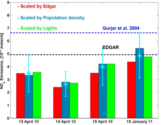
Estimation of NO<sub><b>x</b></sub> emissions from Delhi using car MAX-DOAS observations and comparison with OMI satellite data
Texto
Imagem


Documentos relacionados
There are several ways to identify the presence of clouds: cloud effects can be identified by comparing the derived quantities for a given observation with their clear-sky refer-
In this study a simple profile inversion scheme for the retrieval of aerosol extinction and trace gas concentrations from MAX-DOAS observations (similar to that developed by Li et
Similar discrepancies are found when using the HYSPLIT trajectory model at different altitudes (10–13 km) or the wind speeds and directions, actually measured on board of the
Vertical and slant tropospheric NO 2 -columns from the new satellite instrument SCIA- MACHY on ENVISAT are validated by measurements of the Airborne Multi AXis DOAS
Each of these applications requires detailed and high quality input data from different sources like satellite data, aerial images and ground-based information from
The distribution is a five year error-weighted average of the IASI daytime total columns in the region (a post-filtering excluding cells with less than 10 observations has been
Validation data used for these CO comparisons were pro- vided by eleven ground-based stations, from routine airborne measurements, from one accurate high-altitude balloon-
The highest monthly average values of IO slant columns are found for October and March (springtime and autumn) close to the Antarctic continent, especially in the Weddell Sea,
