1Programa de Pós-Graduação em Geologia e Geoquímica, Universidade Federal do Pará – UFPA, Belém (PA), Brasil. E-mail: [email protected];
[email protected];[email protected]
2Instituto Tecnológico Vale., Belém (PA), Brasil. E-mail: [email protected]
*Corresponding author.
Manuscript ID: 30124. Received: 06/06/2014. Approved: 02/18/2015.
ABSTRACT: The Pleistocene deposits exposed in the Amapá Coastal Plain (onshore portion of the Foz do Amazonas Basin, northeastern South America) were previously interpreted as Miocene in age. In this work, they were named as “Itaubal For-mation” and were included in the quaternary coastal history of Amazonia. The study, through facies and stratigraphic analyses in combination with optically stimulated luminescence (single and multiple aliquot regeneration), allowed interpreting this unit as Late Pleistocene tidal and fluvial deposits. The Itaubal Formation, which unconformably overlies strongly weathered basement rocks of the Guianas Shield, was subdivided into two progradational units, separated by an unconformity related to sea-level fall, here named as Lower and Upper Units. The Low-er Unit yielded ages between 120,600 (± 12,000) and 70,850 (± 6,700) years BP and consists of subtidal flat, tide-influenced meandering stream and floodplain deposits, during highstand conditions. The Upper Unit spans between 69,150 (± 7,200) and 58,150 (± 6,800) years BP and is characterized by braided fluvial deposits incised in the Lower Unit, related to base-level fall; lowstand conditions remained until 23,500 (± 3,000) years BP. The studied region was likely exposed during the Last Glacial Maximum and then during Holocene, covered by tidal deposits influenced by the Amazon River.
KEYWORDS: Amazonia; Pleistocene; sea-level changes; coastal deposits; Itaubal Formation.
RESUMO: Depósitos pleistocenos expostos na Planície Costeira do Ama-pá (porção onshore da Bacia da Foz do Amazonas, nordeste da América do Sul) foram anteriormente interpretados como de idade miocena. Neste trabalho, esses depósitos foram chamados de “Formação Itaubal” e incluí-dos na evolução costeira quaternária da Amazônia. O estudo, mediante o uso de análise de fácies e estratigraia em combinação com luminescência opticamente estimulada (regeneração de alíquotas simples e múltiplas), per-mitiu posicionar essa unidade no Pleistoceno Tardio, interpretada como de-pósitos luviais e inluenciados por maré. A Formação Itaubal, que sobrepõe discordantemente rochas intensamente intemperizadas do embasamento do Escudo das Guianas, foi subdivida em Unidade Inferior e Superior, de caráter progradante, separadas por desconformidade relacionada à que-da do nível do mar. A Unique-dade Inferior apresenta ique-dades entre 120.600 (± 12.000) e 70.850 (± 6.700) anos AP e consiste de depósitos de submaré, canal luvial meandrante inluenciado por maré e depósitos de planície de inundação, depositados durante condições de nível de mar alto. A Unidade Superior apresenta idades entre 69.150 (± 7.200) e 58.150 (± 6.800) anos AP e é caracterizada por depósitos de canal entrelaçado, que retraba-lham a Unidade Inferior, depositada em condições relacionadas à queda do nível de base. Condições de nível de mar baixo permaneceram até 23.500 (± 3.000) anos AP. A região estudada foi provavelmente exposta durante o Último Máximo Glacial e, posteriormente, durante o Holoceno, recoberta por depósitos inluenciados por maré oriundos do Rio Amazonas. PALAVRAS-CHAVE: Amazônia; Pleistoceno; mudanças no nível do mar; depósitos costeiros; Formação Itaubal.
Late Pleistocene sea-level changes
recorded in tidal and luvial deposits
from Itaubal Formation, onshore portion
of the Foz do Amazonas Basin, Brazil
Mudanças no nível do mar durante o Pleistoceno Tardio registradas
em depósitos luviais e inluenciados por maré da Formação
Itaubal, porção onshore da Bacia da Foz do Amazonas, Brasil
Isaac Salém Alves Azevedo Bezerra1*, Afonso César Rodrigues Nogueira1, José Tasso Felix Guimarães1,2,Werner Truckenbrodt1
INTRODUCTION
he Cenozoic siliciclastics deposits exposed in the Amapá Coastal Plain (ACP) have traditionally been interpreted as alluvial fans, luvial and lacustrine depos-its representative of the Miocene Barreiras Formation, a characteristic unit mainly exposed along the northern and northeastern Brazilian coast, and sand and muddy terraces deposits formed by sediments derived from the Amazon River, during Holocene (Lima et al. 1974, 1991; Mendes 1994; Silveira 1998; IBGE 2003; CPRM 2004; Santos 2006; Guimarães et al. 2013a, 2013b). However, Souza (2010) suggests tidal inluence in Miocene deposits and, based on low-resolution optically stimulated lumi-nescence — OSL (multiple aliquot regeneration), indi-cates Late Pleistocene age for the older rocks.
In this work, we reviewed the older rocks using facies and stratigraphic analyses in combination with high-resolution OSL (single and multiple aliquot regen-eration). Our data confirm the Late Pleistocene age and the influence of sea-level changes in these deposits, named here as “Itaubal Formation”. Two progradational units can be differentiated: a Lower Unit, consisting of tide-influenced deposits, and an Upper Unit, compris-ing mainly fluvial sediments. Until now, the Pleistocene deposits have been described only in the coast of French Guiana (Coswine Formation; Boye and Cruys 1961) and Suriname (Coropina Formation; Roeleveld and Van Loon 1979; Krook 1979; Wong et al. 2009), 200 km to the north of the ACP. The Itaubal Formation can be correlated with Pós-Barreiras sediments, exposed in the Marajó Graben and Bragantina Platform, northern coast of Brazil; (Rossetti et al. 1989; Rossetti 2004; Rossetti and Valeriano 2007). Pleistocene deposits exposed in the ACP, onshore portion of the Foz do Amazonas Basin, northeastern South America, are included now in the Quaternary coastal history of Amazonia.
REGIONAL SETTING
he siliciclastics Pleistocene deposits of the eastern por-tion of the ACP overlie the Archean to Mesoproterozoic basement of the Guianas Shield, composed of crystalline and metasedimentary rocks (Fig. 1; Lima et al. 1974, 1991; Souza 2010).
he study area is located in the onshore portion of the Foz do Amazonas Basin, comprising the Amapá Platform (Fig. 1A), while the ofshore portion of this region is rep-resented in the Amazon Fan that also includes the Marajó
Basin (Grossmann 2002; Soares Júnior et al. 2008). he northwestern and southeastern limits of the basin are the Demerara Plateau and the Santana Island of the Pará-Maranhão Basin, respectively (Brandão and Feijó 1994). The Foz do Amazonas Basin is linked to the Marajó Graben System evolution related to several episodes of extensional tectonics succeeded by Gondwana break up and opening of the Equatorial Atlantic from the Triassic to the Cretaceous (Galvão 1991; Rodarte and Brandão 1988; Soares Júnior et al. 2008). The Neogene-Quaternary sedimentation in the Foz do Amazonas basin was influenced by climatic and global sea-level changes, associated with the establishment of the paleo-Amazon River during the Late Miocene (Miller et al. 1987; Haq
et al. 1988; Lopez 2001; Uba et al. 2007; Garzione et al. 2008; Souza 2010). The onset of the Amazon Fan was characterized by deposition of the Tucunaré, Pirarucu and Orange Formations constituting the Pará Group (Brandão and Feijó 1994; Figueiredo et al. 2009). During the Pleistocene to Holocene, sea-level changes caused subaerial exposure succeeded by flooding of the Amapá Platform (Lopez 2001; Souza 2010).
METHODS
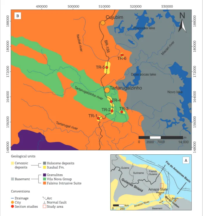
he deposits of the Itaubal Formation were studied on the roadcuts of BR-156 highway, near the town of Tartarugalzinho, State of Amapá, Brazil, about 100 km inland from the coastline and 15 to 20 m above sea-level (Fig. 1B). here, they form a 10 m thick interval of sand and clays with subordinate gravels.
Stratigraphic logs and panoramic sections were described and photographed, and paleocurrent data were measured. he obtained information was used in making facies analy-sis and stratigraphic correlation (Walker 1992; Miall 1991, 1994). Grain size analyses using classic sieving methods of Folk (1974) completed the facies data.
Ten samples of medium to coarse sand were collected for high-resolution OSL dating (single and multiple aliquot regeneration — OSL/SAR-MAR), following the procedures of Murray and Wintle (2000). he samples were analyzed in the Faculdade de Tecnologia do Estado de São Paulo (FATEC) with a Photomultiplicator horn EMI Electron Tubes, Type 9235QA, for accumulated doses and with a Canberra Inspector Portable Spectroscopy Workstation (NaI - Tl) for annual doses. More details about the appli-cation of OSL/SAR-MAR protocols in Pleistocene depos-its of the northern Brazilian coast can be found in Tatumi
RESULTS
Optically stimulated luminescence dating
Considering the OSL/SAR dating, the sediment samples in log TR2 yielded ages of 120,600 (± 12,000),
99,800 (± 12,200) and 70,850 (± 6,700) years BP, while
ages of 100,000 (± 11,500), 96,800 (± 8,250) and 75,300
(± 8,500) years BP were obtained in log TR1, TR4 and
TR5, respectively (Fig. 2; Tab. 1). he youngest ages were detected in log TR5, with 69,150 (± 7,200) years
BP, and in log TR3, with 58,150 (± 6,800) years BP
(Fig. 2; Tab. 1).
Considering the OSL/MAR dating, the sediment sam-ples in log TR2 yielded an age of 78,000 (± 12,000) years
BP. he youngest age was detected in log TR6, with 23,000 (± 3,000) years BP (Fig. 2; Tab. 1).
Figure 1. (A) Geological settings of Norteastern South America and location of study area. (B) Geological map of the onshore portion of the Foz do Amazonas Basin, with the location of the studied sections of the Itaubal Formation (Souza 2010).
Cenozoic deposits
Holocene deposits Itaubal Fm.
Basement
Granulites Vila Nova Group Falsino Intrusive Suite
148000
188000
180000
172000
164000
156000
148000
188000
490000 500000 510000 520000 530000
180000
172000
164000
156000
Conventions Geological units
Drainage City
Section studies Arc Normal fault Study area B
Figure 2. Stratigraphic logs of the Itaubal Formation. Facies association
AF1 – Subtidal flat AF2 – Tide-influenced
meandering strem channel AF3 – Floodplain AF4 – Braided stream channel
Facies
Gravel with incipient even
parallel stratiication (Gp) Wavy-bedded rhythmites (Rw)/ Wavy to flaser tidal rhythmites (Hwf)
Sand with Trough
cross-stratiication (St)
Sand with even parallel
stratiication (Facies Sh)
Sand with tangential
cross-stratiication (Stg)
Sand with climbing ripple
cross-lamination (Scc)
Massive to laminated
mud (Mml) Sand/mud with inclined heterolitic cross-bedding (SMi)
Sand with sigmoidal
cross-stratiication (Ssg)
Massive
sand (Sm)
Structures
Basement Sandstone bouder Ferruginous duricrust Mud clast
Trace fossil
White sand
Fossilized trunks Fining and thinning upward Paleocurrent
Grain size scale
Gravel Coarse Medium Fine Mud
Sand
Table 1. Radioactive data, annual dose values and OSL/SAR-MAR ages of the sediment samples.
Sample
name Protocol
Th (ppm)
U (ppm)
K (%)
Annual dose (µG/yr)
Accumulated dose
Mean Age (yr BP)
TR6-1 MAR 6,234 ± 0,224 1,852 ± 0,161 0,520 ± 0,075 1.730 ± 130 40,78 23,500 ± 3,000
TR5-2 SAR 16,514 ± 0,595 4,578 ± 0,280 0,242 ± 0,035 2830 ± 155 195,4 69,150 ± 7,200
TR5-1 SAR 4,892 ± 0,176 1,693 ± 0,038 0,466 ± 0,068 1470 ± 90 110,8 75,300 ± 8,500
TR4-1 SAR 9,523 ± 0,343 2,507 ± 0,080 0,070 ± 0,010 1610 ± 60 156,1 96,800 ± 8,250
TR3-1 SAR 13,500 ± 0,486 4,666 ± 0,030 1,375 ± 0,199 3690 ± 250 214,6 58,150 ± 6,800
TR2-4 SAR 16,706 ± 0,601 4,678 ± 0,154 0,290 ± 0,042 2880 ± 130 204,2 70,850 ± 6,700
TR2-3 MAR 8,221 ± 0,296 1,719 ± 0,421 0,154 ± 0,022 1470 ± 150 114,50 78,000 ± 12,000
TR2-2 SAR 7,597 ± 0,273 2,421 ± 0,140 0,128 ± 0,019 1500 ± 75 180,4 120,600 ± 12,000
TR2-1 SAR 6,444 ± 0,232 2,615 ± 0,140 0,545 ± 0,079 1890 ± 135 188,0 99,800 ± 12,200
TR1-1 SAR 9,025 ± 0,325 2,902 ± 0,282 0,083 ± 0,012 1680 ± 110 167,9 100,000 ± 11,500
Facies analysis
he succession of the Itaubal Formation consists pre-dominantly of very ine to coarse sands and clay, locally gravel (with rare boulders), organized in centimeter-scale coarsening-upward cycles. his formation overlying an unconformity developed on strongly weathered basement crystalline rocks. Pleistocene deposits are also weathered and, many times, their distinction of the weathered base-ment rocks is diicult. he Itaubal Formation was subdi-vided into two units, separated by an unconformity, and comprises four facies associations (FA). he Lower Unit is represented by subtidal lat deposits (FA1), tide-inluenced
meandering- stream deposits (FA2) and loodplain depos-its, while the Upper Unit is characterized by braided stream deposits (FA3) (Fig. 2; Tab. 2). In the following paragraphs, facies associations are discussed. For a more detailed description of facies, see Tab. 2.
Lower unit
Table 2. Summary of facies descriptions and sedimentary processes in the Itaubal Formation.
Facies Description Process FA
Upper Unit
Coarse sand with trough
cross-stratiication
(Facies St)
Medium to coarse sands with trough cross-stratiication
with set thickness up to 2.5 m; quartz and brownish, deformed mud granules scattered at the base. Grains are
poorly- to moderately sorted.
Migration of 3D bedforms with sinuous crests
under lower flow regime. Reworking of mud beds in
hydroplastic condition.
Braided stream
channel (F
A4)
Sand with tabular
cross-stratiication
(Facies Sp)
Brownish, medium sands with tabular
cross-stratiication. Beds are lenticular, up to 1 m thick,
and interbedded with Facies St.
Migration of 2D bedforms with straight crests under
lower flow regime.
Sand with sigmoidal
cross-stratiication
(Facies Ssg)
Brownish medium sands with sigmoidal
cross-stratiication with sets covered by clay laminae,
and interbedded with Facies Mml of the FA3.The grains
are poorly-sorted, displaying positive asymmetry and
kurtosis with leptokurtic distribution.
Bedform migration under unidirectional and lower
flow regime, with rapid deceleration when it reaches a floodplain lake or pound. Clay laminae can also be
formed by gradual deposition in this process.
Massive muds
(Facies Mm)
Whitish to reddish, centimetric beds of massive clay
with lenticular geometry, illing curved base of beds. Deposition of mud under slack water conditions
Lower Unit
Intraformational
massive mud clast (Gi) Yellowish to reddish, massive laminae of gravels, formed by intraformational mud pebbles and cobbles.
Reworking of laminated mud beds by energetic flood fluvial process. (F Floodplain
A3)
Massive to laminated
mud (Facies Mml)
Reddish-whitish, laminated mud beds of up to 50 cm,
interbedded with sigmoidal cross-stratiication that, in general, ills channelized bedforms.
Alternation between traction and mainly gravitational
settling from suspension.
Gravel with incipient, even parallel stratiication
(Facies Gp)
Brownish to whitish, channelized beds with gravel of lag
deposits from basement rocks and ferruginous sandstone boulders (up to 82 cm).
High to moderate flows generating scours in talweg
portions of channels. Lateral migration produces intense reworking of ferruginized ancient siliciclastics deposits
and basement rocks.
Tide-influenced meandering
stream channel(F
A2)
Medium- to coarse-grained sands with trough
cross-stratiication (Facies St)
Whitish coarse-sand beds with trough cross-stratiication
(sets up to 35 cm thick). Scattered quartz pebbles in the base of sets. The grains moderately-sorted.
Migration of 3D bedforms with sinuous crests in
longitudinal bedforms, under high to moderate flow regime.
Medium-grained sand with tangential
cross-stratiication
(Facies Stg)
Reddish medium sands forming tabular sets of tabular to tangential planar cross-bedding. They are truncated by
sets of facies Sth.
Migration of 2D bedforms on the channel complex bar,
under moderate flow regime.
Hetherolitic cross-bedding sets with alternating sand and mud laminae (Facies SMi)
Dark brown to whitish, inclined medium to coarse sand beds alternating with mud laminae. They can be interbedded with Facies Mml. The grains are
moderately-to poorly-sorted. The upper portion of the strata is marked by ripple marks.
Lateral accretion in concave marginal portions with sand and mud deposited during moderate- and low-energy flows,
respectively, of large to medium-scale point bars.
Small-scale bedforms can also migrate onto these bedforms.
Wavy-bedded rhythmites
(Facies Rw)
Centimetric to metric yellowish to brownish wavy mud laminae alternated with ripple-bedded ine sand layers
that can be interbedded with Facies SMi.
Alternating periods of mud and sand deposition from
suspension and bedload transport, respectively.
Fine-grained sands with
trough cross-stratiication
(Facies St)
Reddish, ine to medium sand with trough cross-stratiication with sets up 30 cm thick. Bedding
planes and foresets are covered by clay laminae.
Intraformational granules with rounded to tabular clay granules occur scattered along the bottom set.
Migration of 3D bedforms with sinuous crest under high
to moderate energy and tidal influence, with alternation
between traction and suspension processes. Bedform
migration during flood tidal current, reworking clay
laminae deposited during slack-water conditions.
Subtidal
flat (F
A1)
Fine-grained sand with
tabular cross-stratiication
(Facies Sp)
Reddish, ine to medium sand beds with thickness varying from 20 to 50 cm, with tabular cross-stratiication, and cyclic variations of foreset thickness. Bedding planes and
foresets, are locally covered by clay laminae.
Migration of 2D subaqueous bedforms with straight crests. This process alternates with slack-water conditions
forming mud drapes on the foresets. Variations in the foreset thickness are related with neap-spring cycles.
Fine-grained sand with tangential
cross-stratiication
(Facies Stg)
Reddish ine to medium sands with tangential to quasi-tabular planar cross-stratiication
interbedded with Facies Sth. Mud drapes occur in the foresets and bedding planes.
Migration of 2D bedforms in subtidal conditions, with alternations between traction and suspension processes.
Sand with climbing ripple cross-lamination (Facies Scc)
Reddish-pinkish, centimetric, ine to medium sand with
subcritical climbing cross-lamination. Locally slight reworking of the top set of the Facies St and Sp.
Migration of 2D ripples with straight crests, with predominance of traction in detriment of settling from suspension processes. Oscillations of dominant energy
flow can be indicated reworking of Facies St and Sp.
Bioturbated sand (Facies Sb)
Sand beds with intense bioturbation, interbedded with Facies Sth and St.
Intense mixture of ine-grained
sand sediments by bioturbation.
Sand with sigmoidal
cross-stratiication
(Facies Ssg)
Sands with sigmoidal cross-stratiication, about 15 cm thick. Reworked mud clasts can also be observed in the foresets.
Bedform migration with rapid decceleration of the water
flow. Dominant current reworks clay laminae deposited
during slack water.
Sand with even parallel
stratiication (Facies Sh) Centimetric to metric, coarse to medium sand with planar stratiication, locally bioturbated. conditions, some organism can be mixture this sediments.Plane-bed flow under upper flow regime. Aſter this
Wavy to flaser
tidal rhythmites (Facies Hwf)
Centimetric to metric, yellowish to brownish beds with
alternation between massive or laminated sands and mud forming wavy to flaser structures.
Alternation between traction currents that deposited laminated sands (2-D ripples) and slack-water conditions,
with deposition of massive mud, during tidal currents and slack-water, respectively.
Massive mud (Facies Mm) Massive mud beds. Deposition of mud under slack-water conditions.
2.5-m thick, extending laterally hundreds of meters and locally show channelized geometry (Fig. 3). Bedforms and foresets of cross-bedding sets are commonly covered by mud drapes. Paleocurrent trends of cross-bedding are towards NW, N and NE, while a NE-SW bidirectional pattern was obtained from herringbone-cross stratiied sands.
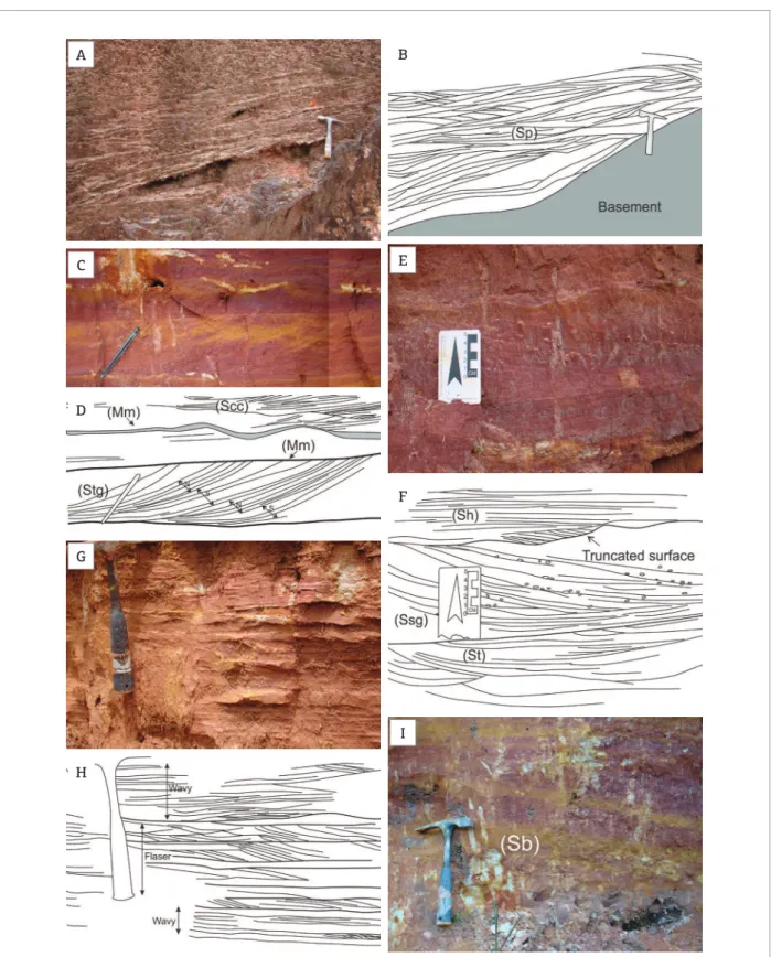
Subtidal flat (FA1)
his facies association forms the lower portion of the Lower Unit, which onlaps the weathered rocks of the base-ment (Figs. 4A and 4B) and consists of sandy and muddy deposits. he sandy deposits are generally ine-grained and display tabular cross-stratiication (Facies Sp), climbing ripple cross-lamination (Facies Scc), sigmoidal cross-stratiication (Facies Ssg), tangential cross-stratiication (Facies Stg), trough cross-stratiication (Facies St) and even-parallel stratiication (Facies Sh) or are homogenized by bioturbation (Facies Sb).
Additionally, wavy to laser tidal rhythmites (Facies Hwf ) and massive mud (Facies Mm) were observed. he Facies Ssg, Stg and Sp are interpreted as tidal bundle (cf. Boersma 1969) (Figs. 4C to 4F). Sand and mud intercalations with wavy bedding grading vertically into laser bedding are interpreted as tidal rhythmites (Figs. 4G and 4H). Cross lamination is rare and generally the lenses are internally homogeneous. Some portions of the sandy facies are heavily bioturbated with no primary structures preserved (Facies Sb; Fig. 4I). Herringbone cross-stratiication with mud drapes occurs locally and record lood-ebb tidal currents.
Tide-influenced meandering stream channel (FA2)
his facies assocation is characterized mainly by tabular geom-etry with rare and isolated channels interbedded with tidal deposits of FA1 (Figs. 5A to 5C). he very coarse-grained sands and gravel deposits of FA2 onlap basement rocks along an angular erosive
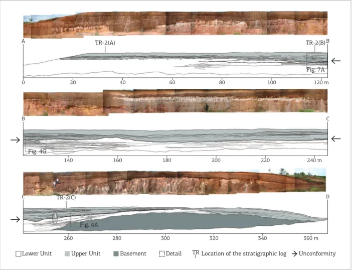
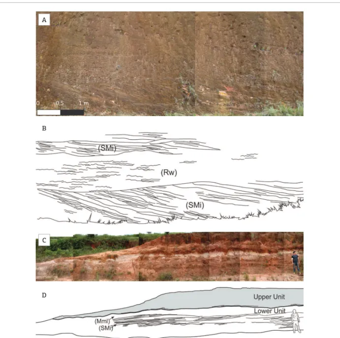
Figure 3. Photomosaic of TR2 in the Itaubal Formation exposed along BR-156 highway, near the town of Tartarugalzinho (Amapá State). The main characteristic of the Lower Unit is its tabular beds extending laterally over hundreds of meters, covered by mud drapes. The base of the Upper Unit is an undulating erosional unconformity.
TR-2(A) TR-2(B)
Fig. 7A
0
A B
20 40 60 80 100 120 m
Fig. 4G
140
B C
160 180 200 220 240 m
Unconformity TR-2(C)
Fig. 4A
260
C D
280 300 320 340 360 m
Figure 4. Field photographs and interpreted sketches of subtidal lat (FA1) deposits. (A and B) Sand and mud deposits onlapping the weathered basement. (C and D) facies Stg with tidal bundle made of spring-tide (S) and neap-tide (N) lamina sets. The bedform of the cross-bedding sets is preserved by mud layer (facies Mm). (E and F) the set of facies St is truncated by facies Ssg and Sh, with the same dip direction of the beds. Mud clast occurs in foreset of facies Ssg. (G and H) wavy bedding grading vertically into laser bedding (facies Hwf). (I) bioturbated sand (facies Sb).
Sp: sand with tabular stratiication; Mm: massive mud; Scc: sand with climbing ripple lamination; Stg: sand with tangential cross-stratiication; Sh: sand with even parallel cross-stratiication; Ssg: sand with sigmoidal cross-cross-stratiication; St: sands with trough cross-cross-stratiication; Sb: bioturbated sand.
A
C
D
G
H
B
E
F
Figure 5. Geometry and contacts of the FA 2: tide-inluenced meandering stream channel. (A) Onlap of facies Rw over basement. (B and C) angular erosive and channelized contact of the facies Gp with basement rocks. (D) gravels (10 cm) from facies Gp. (E) sandstone boulders of Facies Gp (80 cm).
A
B
C
D E
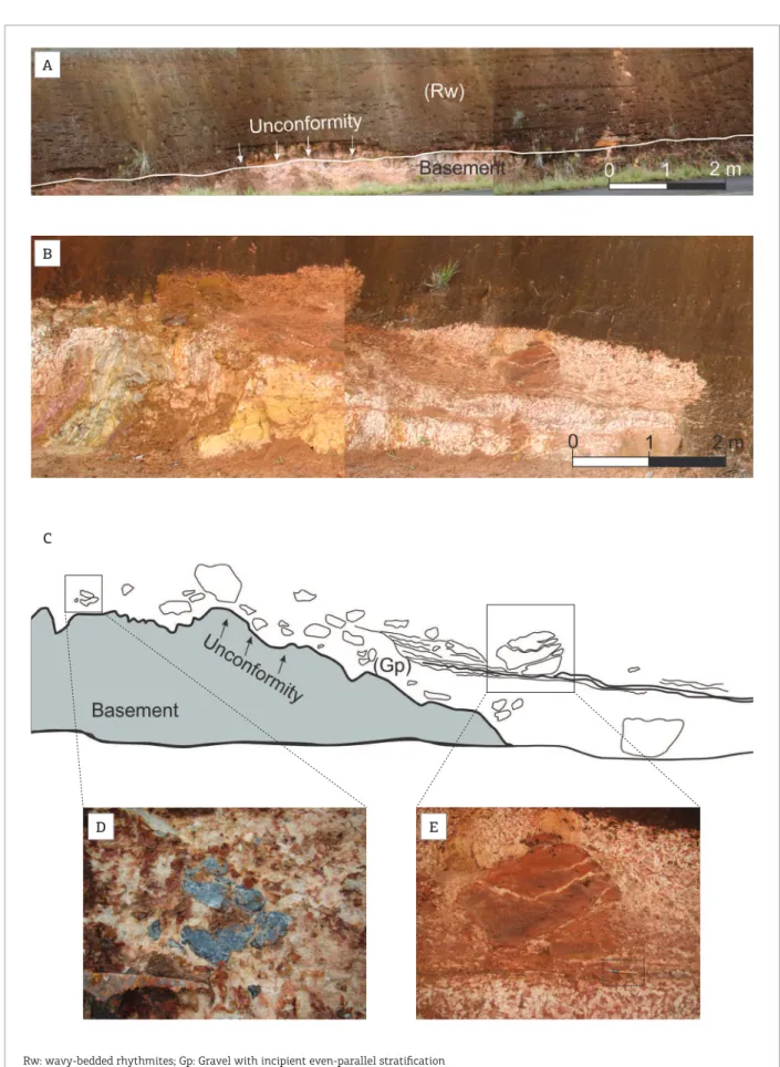
contact (Tab. 2). Gravel with incipient even-parallel stratiication contains pebbles and boulders of iron oxide/hydroxide cemented sandstones and volcanic rocks (Facies Gp) (Figs. 5D and 5E). Medium- to coarse-grained sand with trough cross-stratiication (Facies St), medium-grained sand with tangential cross-stratiica-tion (Facies Stg), and wavy-bedded rhythmites (Facies Rw) are interbedded with Facies Gp. Inclined heterolithic cross-bedded sand and mud (Facies SMi) eventually marked by quartz pebbly lag and massive to laminated mud (Facies Mml) are commonly found in this association (Figs. 6A to 6D).
Floodplain (FA3)
his facies association comprise the upper portion of the Lower Unit and ill an erosional surface with an irregular relief developed on FA1 and FA2 (Figs. 3 and 7). his asso-ciation has a maximum thickness of about 1 m and is later-ally continuous over hundreds of meters. FA3 is organized in small-scale ining-upward cycles, composed of gravel depos-its of intraformational mud clast (Facies Gi) and massive to laminated muds (Facies Mml) (Tab. 2). Mud deposits are generally mottled, showing red and white colors.
Figure 6. General appearance of Facies SMi. (A and B) Facies SMi interbedded with facies Rw. (C and D) facies SMi interbedded with facies Mml.
SMi: hetherolitic cross-bedding sets with alternating sand and mud laminae; Rw: wavy-bedded rhythmites; Mml: massive to laminated mud.
0 0,5 1 m
A
B
C
Upper unit
his 4-m-thick unit consists of brownish to whitish grav-els, medium-to coarse-grained sand and mud and overlies an erosional unconformity (Fig. 2). he sandy deposits are char-acterized by tabular and rarely undulated beds, laterally con-tinuous for hundreds of meters (Fig. 3). A bed of ferruginized sand at the base of this unit marks the contact with the Lower Unit. Cross bedding in the Upper Unit shows paleocurrent direction preferentially to NE. White sands are found along the studied area and are related to pedogenetic horizons or spodosols. he ferruginous soils are in part removed and frag-mented, forming stone lines and stone layers on hillsides.
he Upper Unit is composed of six sedimentary facies grouped into the facies association FA4 and interpreted
as braided stream channel deposits (Tab. 2). FA4 is char-acterized by ferruginous reddish lithiied soil in the upper part (Figs. 7A and 7B). FA4 lies on an erosive contact with FA3 and locally forms channelized geometry. he braided stream channel deposits consist of moderately- to poor-ly-sorted and mostly medium- to coarse-grained sand with trough (Facies St), tabular (Facies Sp) and sigmoidal cross-stratiications (Facies Ssg) (Tab. 2). Massive mud deposits (Facies Mm) are common and are locally covered with Facies Ssg. Facies St is predominant in this associa-tion and generally exhibits gravelly lags composed of mud clasts and wood fragments, fossilized by iron oxide-hydrox-ides. Massive sandy beds with rare iron oxide concretions overlie quartzite and weathered volcanic basement rocks.
Figure 7. General appearance of the contact between Lower Unit and the Upper Unit. (A and B) Contact marked by an irregular relief illed by facies Mml, FA3 and FA4 interbedded with facies Ssg. (C) FA4 overlying FA3. (D) basal part of the FA3 marked by facies Gi reworking facies St of the Lower Unit.
St: sands with trough cross-stratiication; Ssg: sand with sigmoidal cross-stratiication; Mml: massive to laminated mud; Gi: intraformational massive mud clast.
A
B
C
DISCUSSION
Paleoenvironment evolution
of the Itaubal Formation
he Itaubal Formation, which unconformably overlies a weathered Precambrian basement, consists of two pro-gradational units, the Lower and Upper Units, separated by an unconformity, related to a sea-level fall. he pres-ence of the Pleistocene Itaubal Formation just above the underlying strong weathering basement rocks suggests the absence of the Barreiras Formation in the ACP, and probably western border of the Marajó Graben being an uplifted area during the Miocene-Pliocene.
After the drowning of the putatively incised valleys, ine-grained deposits form an extensive tidal lat system in the ACP (Lower Unit), in highstand conditions (Fig. 8 and HSST 1 in Fig. 9 — stages 1 and 2). he Lower Unit rep-resents tide-inluenced deposits of the outer portion of the ACP between 120,600 (± 12,000) and 70,850 (± 6,700)
years BP (Fig. 9 — stage 2). his event is correlated with the Last Interglacial and Marine Isotope Stage 5 and 4/5 (Lisiecki and Raymo 2005). Subaqueous dunes were the main bedforms in the tidal lat induced by tidal currents, alternating with slack water conditions (e.g. Visser 1980; Tessier 1993; Dalrymple and Choi 2007). Tide-inluenced
meandering luvial channels were incised in the tidal lat and partially on the weathered basement. Point bars were depos-ited under moderate to lower energy lows in the concave up margin of channels (e.g. homas et al. 1987). Erosion of cut bank was accompanied of gravitational failures and generated intraformational deposits.
he event of falling-stage (FSST 1) promoted a renewal of luvial incision between 69,150 (± 7,200) and 58,150
(± 6,800) years BP with the establishment of a
high-en-ergy braided stream environment, with ephemeral lood-plains, prograding over tide deposits of the Lower Unit (Fig. 9 — stage 3). he lowstand conditions (LSST 2) remained until 23,500 (± 3,000) years BP, coinciding with
the Last Glacial Maximum of the Wisconsin (Fig. 9 — stage 4) (Maslin and Burns 2000; Maslin et al. 2006; Miller et al. 2005). he Upper Unit is also correlated with Marine Isotope Stage 4, 3 and 2/3.
During the Last Glacial Maximum, the Itaubal Formation was entirely exposed, undergoing ferruginization and reworking. As a result, it was partially eroded and its rem-nants form currently residual terraces discontinuously distributed along the coast (Fig. 9 — stage 4). After this period, Holocene sands and muds from the Amazon River were deposited, forming the modern tidal lats of the ACP (Fig. 9 — stage 6; Guimarães et al. 2012, 2013b).
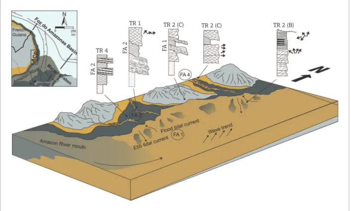
Figure 8. Depositional model of the Itaubal Formation. TR 4
FA
2
FA
2
FA
1
Figure 9. (A) Proposal for the system tract of the Foz do Amazonas Basin. The Itaubal Formation occurs in onshore portion. (B) Paleoenvironmental evolution and sea-level changes during the Itaubal Formation times and relation with sea-level curve from Maslin et al. (2006).
Foz do Amazonas Basin Onshore portion
(Amapá Coastal Plain)
Offshore portion
10 20 30 40 50 60
Age (kyr)
70 80 90 100 110 120
Mean sea lev
el (m)
30 0 -20 -40 -60 -80 -100 -120
LGM
Upper Unit Stage 2/3-3-4 MIS
Itaubal Formation
Lower Unit Stage 5/4-5 MIS 5
5
Holocene
4
Last Glacial Maximum (18,000 – 20,000 years BP)
3
69,000 (± 7,200) to 23,500 (± 3,000) years BP
2
120,600 (± 12,000) to 70,850 (± 6,700) years BP
1
Before 120,000 years BP 4
3
2
1
TSST 2
LSST 2
FSST 1 Unconformity
HSST 1
Sea level LSST 1 to TSST 1
Upliſt River incision
Basement
TSST – Trangressive stage system tract FSST – Falling stage system tract
HSST – Highstand stage system tract LSST – Lowstand stage system tract
Lateritic terraces Fluvial deposits Transitional deposits A
Correlation with Pleistocene
units of northern South America
The evolution of the ACP is comparable with the Suriname Coastal Plain (SCP) (Fig. 10), located 200 km to the north of studied area. The Suriname Coast Plain has been traditionally being subdivided into two geomorphological domains: the older domain was developed mainly in Pleistocene deposits (Coropina Formation) and the younger domain under Holocene sediments (Mara and Coronie Formation) (Veen 1970; Wong 1992; Wong et al. 2009).
he sedimentary history of the Pleistocene Coropina Formation was influenced by global sea-level changes recorded in the Para and Lelydorp members. Braided stream deposits of the Para Member onlapped the bauxitic hardcaps, upper part of the Paleocene-Eocene Onverdacht Formation, called “Bauxite Hiatus” (Wong 1992; Wong
et al. 2009). he development of this unconformity was related to a long period of non-deposition, during Late Eocene to Oligocene (Fig. 10). he meandering channel, chenier and lagoon deposits of the Lelydorp Member over-lap weathered upper part of the Para Member and represent transgressive to highstand phase conditions (Veen 1970; Wong 1992; Wong et al. 2009). he Coropina Formation
was entirely exposed due to sea-level fall, submitted to strongly weathering process and reworked by luvial inci-sion. Afterwards, a transgressive event occurred during the Holocene concomitant with deposition of the Coronie and Mara Formations (Brinkman and Pons 1968; Wong 1992; Wong et al. 2009).
he luvial incision of the Para Member probably correlates with stage 1 (Fig. 9 — stage 1) in lowstand to transgressive conditions (LSST 1-TSST 1), while the upper portion of the Lelydorp Member, formed during transgressive to highstand conditions (HSST 1), may be related to the Lower Unit of the Itaubal Formation (Fig. 9 — stage 2).
The studied deposits are also correlated partially with the Pós-Barreiras sediments of the Marajó Graben system that overlies the Pliocene-Pleistocene lateritic paleosol (Góes 1981; Rossetti 2004) (Fig. 1). In con-trast, Pleistocene deposits in the SCP overlie baux-itic surfaces formed during the Miocene-Pliocene and Eocene-Oligocene (Wong 1992; Wong et al. 2009). he Pós-Barreiras sediments initiated as luvial deposits illing incised paleovalleys during a lowstand, probably correlates with stage 1 (Fig. 9 — stage 1), occurred before 120,000 years BP (Tatumi et al. 2008; Rosseti and Valeriano 2007).
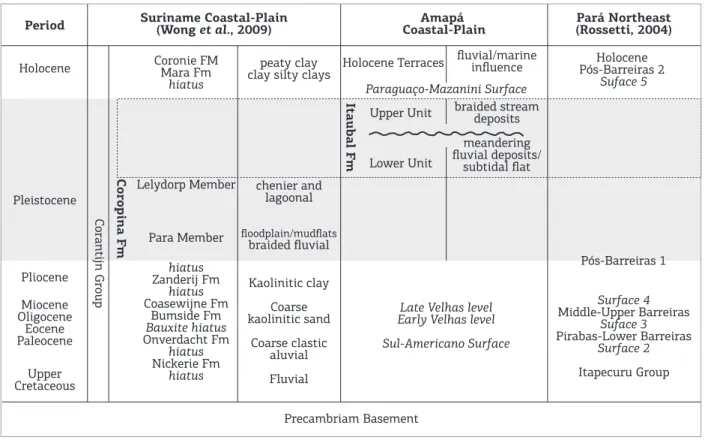
Figure 10. Chart showing the time equivalence of the Pleistocene units of northern South America (Bardossy & Aleva 1990; Rossetti 2004; Wong et al. 2009; Guimarães et al. 2012).
Period Holocene Pleistocene Coronie FM Mara Fm hiatus peaty clay
clay silty clays Holocene Terraces
Holocene Pós-Barreiras 2 Suface 5 Pós-Barreiras 1 Surface 4 Middle-Upper Barreiras Suface 3 Pirabas-Lower Barreiras Surface 2 Itapecuru Group Paraguaço-Mazanini Surface fluvial/marine influence braided stream deposits meandering fluvial deposits/ subtidal flat
Late Velhas level Early Velhas level
Sul-Americano Surface Upper Unit Lower Unit chenier and lagoonal Precambriam Basement Kaolinitic clay Coarse kaolinitic sand Coarse clastic aluvial Fluvial floodplain/mudflats braided fluvial Lelydorp Member Para Member hiatus Zanderij Fm hiatus Coasewijne Fm Bumside Fm Bauxite hiatus Onverdacht Fm hiatus Nickerie Fm hiatus Corantijn Group Coropina F m Itaubal F m Pliocene Miocene Oligocene Eocene Paleocene Upper Cretaceous Suriname Coastal-Plain
Around the 120,000 years BP, transgressive to highstand channel inill is found for the Lower Unit of the Itaubal Formation in the ACP and the upper portion of the Coropina Formation in the SCP.
CONCLUSION
Detailed facies and stratigraphic analyses in combina-tion with high-resolucombina-tion OSL data (single and multiple aliquot regeneration) from Pleistocene deposits, previously related to the Miocene Barreiras Formation, conirmed their Late Pleistocene age. Additionally, we name here these Pleistocene deposits “Itaubal Formation”. his formation, exposed in the Amapá Coastal Plain, onshore portion of the Foz do Amazonas Basin, northeastern South America, unconformably overlies the weathered Precambrian base-ment. he formation was partially eroded and the current morphological conigurations are residual terraces discon-tinuously exposed along the Amapá coast. Afterwards, Holocene tidal deposits partially covered the Itaubal deposits inluenced by the luvial processes related to the Amazon River discharges.
he Itaubal Formation was subdivided into two pro-gradational units, separated by an erosional unconformity. he Lower Unit consists of subtidal and tide-inluenced meandering stream and loodplain deposits distributed in the outer portion of the ACP. It relects a highstand (stage phase) condition occurred between 120,600 (± 12,000)
and 70,850 (± 6,700) years BP. his Lower Unit can
be correlated with the upper portion of the Coropina Formation in the Suriname coastal plain and part of the Pós-Barreiras sediments of the Marajó Graben system.
he Upper Unit was interpreted as braided stream depos-its related to a base-level fall and falling-stage condi-tions, with yielded ages of 69,150 (± 7,200) and 58,150
(± 6,800). Lowstand conditions remained until 23,500
(± 3,000) years BP, during the Last Glacial Maximum,
when the Itaubal Formation was exposed and submitted to ferruginization processes, which led to confusion with the iron-rich Miocene Barreiras deposits.
he absence of the Barreiras Formation in the ACP and the intensely weathered Precambrian basement rocks suggest the western border of the Marajó Graben being an uplifted area during Miocene-Pliocene that, as a geo-graphic barrier, restricted the Miocene deposition in the Bragantina Plataform, northern State of Pará and Suriname Coastal Plain.
ACKNOWLEDGMENTS
his research received funds from Financiadora de Estudos e Projetos (FINEP)/Conselho Nacional de Desenvolvimento Cientíico e Tecnológico (CNPq)/Petróleo Brasileiro S.A. (PETROBRAS)/Fundo Nacional de Desenvolvimento Cientíico e Tecnológico (FNDCT) (2654.09-FINEP) for ield trips and OSL dating. he irst and second authors hold a CNPq scholarship. We thank Odete Fátima Machado da Silveira (in memorian) for discussions and comments relative to the geology of the State of Amapá. We are grateful to Eduardo Souza for their initial discussions about the presence of the Pleistocene deposits in the ACP, which motivated the continuity of this research. We also thank the useful sug-gestions made by the anonymous reviewer.
Bardossy G. & Aleva G.J.J. 1990. Lateritic bauxites. Amsterdam, Elsevier, 624 p.
Boersma J.R. 1969. Internal structures of some tidal megaripples on a shoal in the Westerschelde estuary, the Netherlands. Geologie en Mijnbouw, 48:409-414.
Boye M. & Cruys H. 1961. New data of the coastal sedimentary formations in French Guiana. In: 5º Inter-Guiana Geology Conference. Geological Survey Department, Georgetown, Guyana, Proceedings, p. 145-168.
Brandão J.A.S.L. & Feijó F.J. 1994. Bacia da Foz do Amazonas. Boletim de Geociências da Petrobras, 8:91-94.
Brinkman R. & Pons L.J. 1968. A pedo-geomorphological classiication
and map of the Holocene sediments in the coastal plain of the three Guianas. v. 4. Wageningen, Soil Survey Institute, 41 p.
REFERENCES
CPRM - Serviço Geológico do Brasil. 2004. Carta geológica do Brasil 1:1.000.000. Folha NA.22- Macapá. CD-ROM.
Dalrymple R.W. & Choi K. 2007. Morphologic and facies trends
through the luvial-marine transition in tide-dominated systems: a
schematic framework for environmental and sequence-stratigraphic interpretation. Earth-Science Reviews, 81(3):135-174.
Figueiredo J., Hoorn C., van der Ven P., Soares E. 2009. Late Miocene onset of the Amazon River and the Amazon deep-sea fan: evidence from the Foz do Amazonas Basin. Geology, 37(7):619-622.
Folk R.L. 1974. Petrology of sedimentary rocks. Austin, Hemphill, 184 p.
Garzione C.N., Hoke G.D., Libarkin J.C., Withers S., Mac Fadden B., Eiler J., Ghosh P., Mulch A. 2008. Rise of the Andes. Science,
320:1304-1307.
Góes A.M. 1981. Estudo sedimentológico dos sedimentos Barreiras, Ipixuna e Itapecuru, no nordeste do Estado do Pará e noroeste do Maranhão. MS Dissertation, Instituto de Geociências, Universidade Federal do Pará, Belém, 55 p.
Grossmann G.S. 2002. Processamento e interpretação de dados sísmicos de Parasoud no delta submarino do Amazonas. MS Dissertation, Departamento de Geologia, Universidade Federal Fluminense, Niterói, 78 p.
Guimarães J.T.F., Cohen M.C.L., Franca M.C., Pessenda L.C.R., Behling
H. 2013a. Morphological and vegetation changes on tidal lats of
the Amazon Coast during the last 5000 cal. yr BP. The Holocene,
23(4):528-543.
Guimarães J.T.F., Cohen M.C.L., França M.C., Pessenda L.C.R., Souza
E.J., Nogueira A.C.R., Alves R. 2013b. Recent efects of tidal and
hydro-meteorological changes on coastal plains near the mouth of the Amazon River. Earth Surface Processes and Landforms,
38:1535-1549.
Guimarães J.T.F., Cohen M.C.L., Pessenda L.C.R., Franca M.C., Smith C.B., Nogueira A.C.R. 2012. Mid- and late-Holocene sedimentary process and palaeovegetation changes near the mouth of the Amazon River. The Holocene, 22(3):359-370.
Haq B.U., Handenbol J., Vail P.R. 1988. Mesozoic and Cenozoic chonostratigraphy and cycles of sea-level change. In: Wilgus C.K., Hastings B.S., Kendall C.G.ST.C., Posamentier H.W., Ross C.A., Van Wagoner J.C. (eds.). Sea-level changes – an integrated approach. Special Publication, v. 42. Tulsa, Society of Economic Paleontologists and Mineralogists, p. 71-108.
IBGE - Instituto Brasileiro de Geograia e Estatística. 2003. Base cartográica integrada digital do Brasil ao milionésimo: versão 1.0
para ArcGis Desktop-ArcView. Rio de Janeiro: IBGE, 1 CD-ROM.
Krook L. 1979. Sediment petrographical studies of the Surinam coastal area. PhD Thesis, Free University, Amsterdam, 154 p.
Lima M.I.C., Bezerra P.E.L., Araújo H.J.T. 1991. Sistematização da geologia do estado do Amapá. In: Simpósio de Geologia da Amazônia. Belém, SBG-Núcleo Norte, v. 3, Anais, p. 322-335.
Lima M.I.C., Montalvão R.M.G., Issler R.S., Oliveira A.S., Basei M.A.S., Araújo J.F.V., Silva G.G. 1974. Geologia Folha NA/22 (Macapá). Levantamento de Recursos Naturais, v. 6. Rio de Janeiro, Projeto RADAM, Departamento Nacional de Produção Mineral, p. 1-120.
Lisiecki L.E. & Raymo M.E. 2005. A Pliocene-Pleistocene stack of 57 globally distributed benthic δ18O records. Paleoceanography,
20(1):PA1003.
Lopez M. 2001. Architecture and depositional pattern of the Quaternary deep-sea fan of the Amazon. Marine and Petroleum Geology, 18(4):479-486.
Maslin M.A. & Burns S.J. 2000. Reconstruction of the Amazon Basin
efective moisture availability over the past 14,000 years. Science,
290(5500):2285-2287.
Maslin M.A., Knutz P.C., Ramsay T. 2006. Millenial-scale sea-level control on avulsion events on the Amazon Fan. Quaternary Science Reviews, 25(23-24):3338-3345.
Mendes A.C. 1994. Estudo sedimentológico e estratigráico dos sedimentos holocênicos da costa do Amapá - Setor entre a Ilha de Maracá e o Cabo Orange. MS Dissertation, Instituto de Geociências, Universidade Federal do Pará, Belém, 274 p.
Miall A.D. 1991. Hierarchies of architectural units in terrigenous clastic rocks and their relationship to sedimentation rate.
In: Miall A.D. & Tyler N. (eds.). The three dimensional facies architecture of terrigenous clastic sediments and its implications for hidrocarbon discovery and recovery. Tulsa, Society for Sedimentary Geology/SEPM, p. 6-12.
Miall A.D. 1994. Reconstructing luvial macroform architecture from
two-dimensional outcrops: examples from the Castlegate Sandstone,
Book Clifs, Utah. Journal of Sedimentary Research, 64(2B):146-158.
Miller K.G., Fairbanks R.G., Mountain G.S. 1987. Tertiary oxygen isotope synthesis, sea-level history, and continental margin erosion. Paleoceanography, 2(1):1-19.
Miller K.G., Kominz M.A., Browning J.V., Wright J.D., Mountain G.S., Katz M.E., Sugarman P.J., Cramer B.S., Christie-Blick N., Pekar S.F. 2005. The Phanerozoic record of global sea-level change. Science,
310(5752):1293-1298.
Murray A.S. & Wintle A.G. 2000. Luminescence dating of quartz using an improved single-aliquot regenerative dose protocol. Radiation Measurements, 32(1):57-73.
Rodarte J.B.M. & Brandão J.A.S.L. 1988. Arcabouço estrutural,
estratigraia e perspectivas exploratórias da área de Cassiporé, porção
noroeste da Bacia da Foz do Amazonas. Rio de Janeiro, PETROBRAS.
Roeleveld W. & Van Loon A.J. 1979. The Holocene development of the Young Coastal Plain of Suriname. Geologie en Mijnbouw, 58:21-28.
Rossetti D.F. 2004. Paleosurfaces from northeastern Amazonia as a key for reconstructing paleolandscapes and understanding weathering products. Sedimentary Geology, 169(3-4):151-174.
Rossetti D.F., Rocca R.R., Tatumi S.H. 2013. Datação de sedimentos pós-barreiras, município de Alcântara, litoral maranhense. Boletim do Museu Paraense Emílio Goeldi (Ciências Naturais), 8:11-25.
Rossetti D.F., Trukenbrodt W., Góes A.M. 1989. Estudo paleoambiental
e estratigráico dos sedimentos Barreiras e Pós-Barreiras na região
Bragantina, nordeste do Pará. Boletim do Museu Paraense Emílio Goeldi (Série Ciências da Terra), 1:25-74.
Rossetti D.F. & Valeriano M.M. 2007. Evolution of the lowest Amazon Basin modeled from the integration of geological and SRTM topographic data. Catena, 70(2):253-265.
Santos V.F. 2006. Ambientes costeiros amazônicos: avaliação de
modiicações por sensoriamento remoto. PhD Thesis, Instituto de
Geociências, Universidade Federal Fluminense, Niterói, 306 p.
Silveira O.F.M. 1998. A Planície costeira do Amapá: dinâmica
de ambiente costeiro inluenciada por grandes fontes luviais
quaternárias. PhD Thesis, Instituto de Geociências, Universidade Federal do Pará, Belém, 215 p.
Soares Júnior A.V., Costa J.B.S., Hasui Y. 2008. Evolução da margem atlântica equatorial do Brasil: três fases distensivas. Geociências,
27(4):427-437.
Souza E.J. 2010. Geologia da região costeira do Amapá com ênfase
na estratigraia, morfotectônica e geomorfologia. Monograia de
Conclusão de Curso, Faculdade de Geologia, Universidade Federal do Pará, Belém, 118 p.
Tatumi S.H., Silva L.P., Pires E.L., Rossetti D.F., Góes A.M. 2008.
Datação de sedimentos pós-barreiras no norte do Brasil: implicações paleogeográicas. Revista Brasileira de Geociências, 38(3):514-524.
Tessier B. 1993. Upper intertidal rhythmites in the Mont-Saint-Michel Bay (NW France): perspectives for paleoreconstruction. Marine Geology, 110(3-4):355-367.
Thomas R.G., Smith D.G., Wood J.M., Visser J., Calverley-Range E.A.,
Koster E.H. 1987. Inclined heterolithic stratiication – terminology, description, interpretation and signiicance. Sedimentary Geology,
Uba C.E., Strecker M., Schmitt A.K. 2007. Increased sediment accumulation rates and climatic forcing in the Central Andes during the late Miocene. Geology, 35(11):979-982.
Veen A.W.L. 1970. On geogenesis and pedogenesis in the Old Coastal Plain of Surinam (South-America), v. 14. Amsterdam,
Fysisch-Geograisch en Bodemkundig Laboratorium, 176 p.
Visser M.J. 1980. Neap-spring cycles relected in Holocene
subtidal large-scale bedform deposits: a preliminary note. Geology,
8(11):543-546.
Walker R.G. 1992. Facies, facies models and modern stratigraphic concepts. In: Walker R.G. & James N.P. (eds.). Facies models - response to sea-level change. Ontario, Geological Association of Canada, p. 1-14.
Wong T.E. 1992. Quaternary stratigraphy of Suriname. In: Prost M.T. & Charron C. (eds.). Evolution des littoraux de Guyane et de la zone caraïbe méridionale pendant le Quaternaire. In: Symposium PICG 274/Orstom, Cayenne (Guyane), 9-14 November 1990. Orstom, Paris, p. 559-578.
Wong T.E., de Kramer R., de Boer P.L., Langereis C., Sew-A-Tjon J. 2009.
The inluence of sea-level changes on tropical coastal lowlands; the
Pleistocene Coropina Formation, Suriname. Sedimentary Geology,
216(3-4):127-137.